
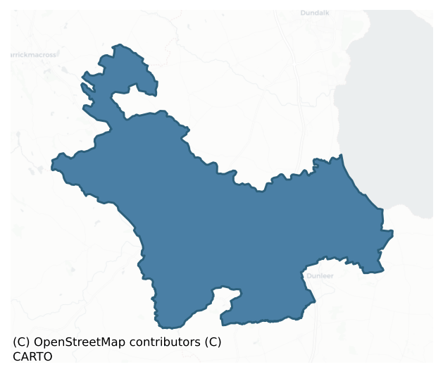
Ardee is a barony of County Louth, in the historical province of Leinster (Irish: Baile Átha Fhirdhia), covering 218 km² of land. The barony records 486 NMS archaeological sites and 183 NIAH listed buildings, placing it at around the 62nd percentile among 280 ROI baronies for sites per km². This means it is in the upper half of all baronies for sites per km². Dated archaeological evidence runs from the Neolithic through to the Modern, spanning 8 of 9 archaeological periods, placing the barony in the 54th percentile among 280 ROI baronies for chronological depth. This means it is in the upper half of all baronies for chronological depth. The largest dated subset of recorded sites dates to the Iron Age. Logainm flags 30 placenames in the barony as carrying a recognised heritage root; the largest share — around 70% — are names associated with pre-christian defensive.
Heritage at a glance
Percentile rankings throughout this profile compare each barony only against the other 279 Republic of Ireland baronies.
The recorded heritage of Ardee
The National Monuments Service Sites and Monuments Record (SMR) is the statutory inventory of archaeological sites for the Republic of Ireland, maintained by the Department of Tourism, Culture, Arts, Gaeltacht, Sport and Media. Sites recorded here include earthworks, ringforts, megalithic tombs, ecclesiastical remains, and post-medieval features; not every record is legally protected, but each is registered as a monument of archaeological interest.
The National Monuments Service records 486 archaeological sites in Ardee, putting it at the 62nd percentile among 280 ROI baronies for sites per km². This means it is in the upper half of all baronies for sites per km². Protection coverage is near-universal — 463 sites (95%) fall within a recorded monument protection zone, indicating an extensively surveyed landscape. The dominant category is defensive sites — ringforts, enclosures, hillforts, and stone forts (236 sites, 49% of the record). The most diagnostically specific type is Souterrain (47 records, 10% of the barony's NMS total) — compared to an ROI average of 4% across all baronies where this type occurs. Souterrain is an underground stone-built passage and chamber, generally Early Medieval and often associated with ringforts as a defensive or storage feature. The broader 'Enclosure' classification — which catches unclassified ringforts and field enclosures — accounts for a further 94 records (19%) and reflects the difficulty of sub-classifying degraded earthworks from surface evidence alone. Across the barony's 218 km², this gives a recorded density of 2.23 sites per km².
Most common monument types
Hover or tap a monument type to see its definition.
| Type | Count |
|---|---|
| Enclosure a banked or ditched feature of uncertain type, used as a catch-all where the original function cannot be determined from surface evidence | 94 |
| Souterrain an underground stone-built passage and chamber, generally Early Medieval and often associated with ringforts as a defensive or storage feature | 47 |
| Ringfort – rath an earthen ringfort enclosed by a bank and external ditch — the most common Early Medieval farmstead, broadly dated 500–1000 AD | 38 |
| Church a building used for public Christian worship, of any date from c. 500 AD onwards | 28 |
| Graveyard a burial area associated with a church, in use from the medieval period onwards | 24 |
| Ritual site – holy well a well or spring traditionally associated with a saint, often credited with healing properties; many trace earlier ritual origins but devotion is documented from the medieval period onwards | 19 |
| Earthwork an unclassified earthen structure with no diagnostic features that allow a more specific classification | 19 |
| Fulacht fia a horseshoe-shaped Bronze Age burnt mound built around a sunken trough beside a water source, traditionally interpreted as a cooking site | 15 |
Chronological distribution
The dated archaeological record for Ardee spans from the Neolithic through to the Modern, with activity attested across 8 of 9 archaeological periods. Every period from earliest to latest is represented in the record — an unbroken sequence of dated activity across the full chronological span. Activity concentrates most heavily in the Iron Age (124 sites, 38% of dated material), with the Early Medieval forming a secondary peak (112 sites, 34%). A further 160 recorded sites (33% of the overall NMS register for the barony) carry no period attribution — appearing as 'Unknown' in the bar chart below. This typically reflects either records that pre-date the standardised period vocabulary or sites awaiting specialist dating review, rather than a genuine absence of chronological evidence.
Sample of recorded monuments
Show 25 sample monuments (of 486 total)
A representative sample of 25 recorded monuments drawn from the barony’s 486 total NMS entries. Sites within a recorded monument protection zone and rarer site types are prioritised so the list shows a meaningful cross-section rather than only the most common type. Each entry shows the official Sites and Monuments Record reference number and the description published by the National Monuments Service.
Barrow – bowl-barrow
The following description is derived from both the published 'Archaeological Inventory of County Louth' (Dublin: Stationery Office, 1986) and the 'Archaeological Survey of County Louth' (Dublin: Stationery Office,…
The following description is derived from both the published 'Archaeological Inventory of County Louth' (Dublin: Stationery Office, 1986) and the 'Archaeological Survey of County Louth' (Dublin: Stationery Office, 1991). In certain instances the entries have been revised and updated in the light of recent research.
Date of upload/revision: 17 July 2007
Situated on slight rise in undulating, outcropping countryside. Circular bowl-barrow (diam. 14.6m, H 0.9m). Excavation by H. Morris in 1926 (CLAJ 1926, 71-6) revealed that the site was comprised of piled stone mixed with earth and numerous fragments of bone. A rectangular cist, aligned NW-SE, almost at the centre of the mound contained four 'urns' (see also LH011-001002-).
Bawn
Field known locally as the 'Castle Field'. Reputedly the site of Niselrath Castle, a probable tower house, described in 1599 as 'a square castle and a great bawne with a good dytche rounde abowte it' (Paterson 1944,…
Field known locally as the 'Castle Field'. Reputedly the site of Niselrath Castle, a probable tower house, described in 1599 as 'a square castle and a great bawne with a good dytche rounde abowte it' (Paterson 1944, 321-2). No visible surface trace.
The above description is derived from both the published 'Archaeological Inventory of County Louth' (Dublin: Stationery Office, 1986) and the 'Archaeological Survey of County Louth' (Dublin: Stationery Office, 1991). In certain instances the entries have been revised and updated in the light of recent research.
Date of upload: 12 April 2012
Inscribed stone
Farm buildings adjacent to possible castle site (LH013-006003-) contain pieces of late medieval dressed stone (LH013-006004-), one bearing the date 1574 (LH013-006005-) and another has the coat of arms of the de Verduns…
Farm buildings adjacent to possible castle site (LH013-006003-) contain pieces of late medieval dressed stone (LH013-006004-), one bearing the date 1574 (LH013-006005-) and another has the coat of arms of the de Verduns and Plunkets (LH013-006006-).
Compiled by: Claire Breen
Date of upload: 25 May 2012
Mill – unclassified
Indicated on Taylor and Skinner's map (1777). Not on any editions of the OS maps.
Compiled by: Claire Breen
Date of upload: 25 May 2012
Burial mound
The following description is derived from both the published 'Archaeological Inventory of County Louth' (Dublin: Stationery Office, 1986) and the 'Archaeological Survey of County Louth' (Dublin: Stationery Office,…
The following description is derived from both the published 'Archaeological Inventory of County Louth' (Dublin: Stationery Office, 1986) and the 'Archaeological Survey of County Louth' (Dublin: Stationery Office, 1991). In certain instances the entries have been revised and updated in the light of recent research.
Date of upload/revision: 17 July 2007
Situated in destroyed enclosure (LH014-014001-) and consisting of an artificially raised mound which contained about twenty burials according to a local informant in 1967. A ridge or bank extended through the centre of the site. The graves consisted of rectangular trenches c. 1.8m long and were filled with dark earth. The burials were orientated E-W. The above description is based on information received from the then owner of the land at the time of the destruction of the enclosure. The site is referred to as 'Lis na Kelic' in the OS Letters (CLAJ 1910, 291), which is possibly a corruption of 'Liss na Relig'.
Linear earthwork
The following description is derived from both the published 'Archaeological Inventory of County Louth' (Dublin: Stationery Office, 1986) and the 'Archaeological Survey of County Louth' (Dublin: Stationery Office,…
The following description is derived from both the published 'Archaeological Inventory of County Louth' (Dublin: Stationery Office, 1986) and the 'Archaeological Survey of County Louth' (Dublin: Stationery Office, 1991). In certain instances the entries have been revised and updated in the light of recent research.
Date of upload/revision: 17 July 2007
Section of drystone-faced earthen bank (Wth c. 2-5m, H 1m) passing along the N side of a mearing which divides the townlands of Cookstown and Tattyboys. This is reputedly a part of the Pale boundary, but is dismissed as such by Tempest (CLAJ 1931, 435).
Cross – Wayside cross
The following description is derived from both the published 'Archaeological Inventory of County Louth' (Dublin: Stationery Office, 1986) and the 'Archaeological Survey of County Louth' (Dublin: Stationery Office,…
The following description is derived from both the published 'Archaeological Inventory of County Louth' (Dublin: Stationery Office, 1986) and the 'Archaeological Survey of County Louth' (Dublin: Stationery Office, 1991). In certain instances the entries have been revised and updated in the light of recent research.
Date of upload/revision: 17 July 2007
Set in a large flat base almost square in plan and sited on a slight ridge, it is now broken into several fragments. Part of the shaft, which is rectangular in section (0.45m by 0.28m), is still bedded in the base but the other portions lay broken on the ground before being removed for repair by the OPW. Its total height would have been c. 3.1m. The apex of the shaft is broken in two but it can be seen that it tapers towards the top. It bears a rough Crucifixion scene on one face and a robed figure on the other. The head of the cross or pillar takes the form of two truncated pyramids set base to base. The top of the shaft is tenoned to fit a mortise in the head which is decorated with floral patterns and angles. The sides have figures of St Peter and St Patrick under ogee-headed canopies. An inscription in relief covers all four faces of the shaft. The cross is one of a pair of crosses set up by Jennet Dowdall in memory of her second husband, Oliver Plunket, who died in 1607; the other is to be seen at Baronstown, Co. Meath (King 1984, 105 and 112). (CLAJ 1943, 210-15; King 1984, fig. 4, D, 112)
Religious house – Knights Templars
The following description is derived from both the published 'Archaeological Inventory of County Louth' (Dublin: Stationery Office, 1986) and the 'Archaeological Survey of County Louth' (Dublin: Stationery Office,…
The following description is derived from both the published 'Archaeological Inventory of County Louth' (Dublin: Stationery Office, 1986) and the 'Archaeological Survey of County Louth' (Dublin: Stationery Office, 1991). In certain instances the entries have been revised and updated in the light of recent research.
Date of upload/revision: 17 July 2007
Preceptory of Knights Templars recorded at Kilsaran in 1307. No visible trace. (Leslie 1908, 21; CLAJ 1943, 207)
Milestone
The Archaeological Survey of Ireland (ASI) is in the process of providing information on all monuments on The Historic Environment Viewer (HEV). Currently the information for this record has not been uploaded. To…
The Archaeological Survey of Ireland (ASI) is in the process of providing information on all monuments on The Historic Environment Viewer (HEV). Currently the information for this record has not been uploaded. To access available information for research purposes please make an appointment in advance with the Archive Unit (open Fridays 10.00 am – 5.00 pm), Department of Culture, Heritage and the Gaeltacht, The Custom House, Dublin 1 D01W6XO or email nmarchive@chg.gov.ie.
Cliff-edge fort
The following description is derived from both the published 'Archaeological Inventory of County Louth' (Dublin: Stationery Office, 1986) and the 'Archaeological Survey of County Louth' (Dublin: Stationery Office,…
The following description is derived from both the published 'Archaeological Inventory of County Louth' (Dublin: Stationery Office, 1986) and the 'Archaeological Survey of County Louth' (Dublin: Stationery Office, 1991). In certain instances the entries have been revised and updated in the light of recent research.
Date of upload/revision: 17 July 2007
Situated on a height to the SW of the River Glyde. Oval area (max. dims. 73m E-W, 34m N-S) bounded by cliff edge to N and slight bank (H 1.4m) with external fosse (Wth 2.8m, D 0.4m) on other sides. The external fosse has been incorporated into modern field-drainage systems at WSW, and on the N-NE the cliff edge has been scarped during OPW river drainage.
At E of interior is a circular hut site (LH015-015002-) (int. diam. 4.2m) delimited by a slight bank (Wth 1m, H 0.2m). Adjacent to this hut site, on the edge of the interior of the site, are two banks suggesting the former existence of a larger, rectangular hut (LH015-015003-). Historical evidence (CLAJ 1909, 140-1) suggesting a Danish presence at Annagassan from as early as 831 until at least 926 has led to the suggestion that this is a viking longphort. However, the only find associated with the site is a coin hoard of fourteenth-century date from the base of the cliff to the NE of the site (CLAJ 1929, 42-5).
This monument is subject to a preservation order made under the National Monuments Acts 1930 to 2014 (PO no. 2/1971) and is a National Monument, in state guar…
Ecclesiastical enclosure
Cropmarks of two sets of double fosses visible on aerial photographs (CUCAP, BDS 67; GB89.D.30 & 46). Cropmarks appear to be circling Strabannan church and graveyard (LH015-023001- and LH015-023002-), indicating a large…
Cropmarks of two sets of double fosses visible on aerial photographs (CUCAP, BDS 67; GB89.D.30 & 46). Cropmarks appear to be circling Strabannan church and graveyard (LH015-023001- and LH015-023002-), indicating a large ecclesiastical enclosure (estimated diam. c. 250m).
Compiled by: Claire Breen
Date of upload: 6 June 2012
House – 17th century
The present castle Bellingham was built c. 1690/1700 after the original castle (LH015-009—-) was burnt down in the mid-17th century. Alterations were carried out in the late 18th century and again in the early 19th…
The present castle Bellingham was built c. 1690/1700 after the original castle (LH015-009—-) was burnt down in the mid-17th century. Alterations were carried out in the late 18th century and again in the early 19th century. It has a nine bay entrance front with one bay projecting out, is three storeys high with battlemented parapet and some turrets. (Bence-Jones 1988, 62)
Compiled by: Claire Breen
Date of upload: 15 June 2012
Road – road/trackway
Said to be known locally as the 'Long Man's Bed' (Mac Ivor 1956, 406-7), it is marked as a double ditch on the 1835 'OS 6-inch' map. Inspection in 1966 suggests it is a laneway defined by a modern road fence at the S…
Said to be known locally as the 'Long Man's Bed' (Mac Ivor 1956, 406-7), it is marked as a double ditch on the 1835 'OS 6-inch' map. Inspection in 1966 suggests it is a laneway defined by a modern road fence at the S and another older earth and stone bank just N of it.
Compiled by: Claire Breen
Date of upload: 19 June 2012
Ogham stone
Situated just W of the summit of a high E-W ridge. This is a large block-like boulder (max. dims. H 2.1m, 1.2m by 0.9m in section) orientated NW-SE. The lower corners of the stone have been worn smooth by cattle…
Situated just W of the summit of a high E-W ridge. This is a large block-like boulder (max. dims. H 2.1m, 1.2m by 0.9m in section) orientated NW-SE. The lower corners of the stone have been worn smooth by cattle scratching. The remains of an ogham inscription, probably added to the existing standing stone early in the first millennium AD, can be seen on the upper part of the E corner. This inscription, as read from the base up, has been transliterated as 'BRANOGENI' by Macalister (CLAJ 1915, 385-6; 1945, 44, no. 39). (Buckley 1986, no. 186)
Compiled by: Nora White
Date of upload: 19 September 2016
Holed stone
The following description is derived from both the published 'Archaeological Inventory of County Louth' (Dublin: Stationery Office, 1986) and the 'Archaeological Survey of County Louth' (Dublin: Stationery Office,…
The following description is derived from both the published 'Archaeological Inventory of County Louth' (Dublin: Stationery Office, 1986) and the 'Archaeological Survey of County Louth' (Dublin: Stationery Office, 1991). In certain instances the entries have been revised and updated in the light of recent research.
Date of upload/revision: 17 July 2007
Situated in low-lying pasture, overlooked by a broad ridge to S and SE. Roughly square-shaped slab (max. dims. H 1.7m, 1.8m by 0.3m in section) orientated roughly N-S. Slightly off-centre is an hourglass perforation (diams. 0.2-0.25m) which gives the name to the stone and to the townland. (CLAJ 1914, pl. opp. 248; 1929, 59; 1962, 164)
Ritual site – holy/saint's stone
A stone bearing the mark of St. Kevin's knees is said to be located at St. Kevin's Well (LH017-064001-) (IFC Schools MSS 674, 60). No visible trace of either at ground level. An archaeological assessment (Excavation…
A stone bearing the mark of St. Kevin's knees is said to be located at St. Kevin's Well (LH017-064001-) (IFC Schools MSS 674, 60). No visible trace of either at ground level. An archaeological assessment (Excavation Licence 98E584) was carried out immediately to the E but did not reveal anything of archaeological interest (Meenan 1998).
Compiled by: Claire Breen
Date of upload: 21 June 2012
Barrow – mound barrow
Situated on top of a steep-sided hill, with excellent visibility in all directions, 13.5m SE of the centre of ceremonial enclosure (LH017-074001-). It is a circular grass-covered mound (diam. 11m; H 0.55m).
The above…
Situated on top of a steep-sided hill, with excellent visibility in all directions, 13.5m SE of the centre of ceremonial enclosure (LH017-074001-). It is a circular grass-covered mound (diam. 11m; H 0.55m).
The above description is derived from both the published 'Archaeological Inventory of County Louth' (Dublin: Stationery Office, 1986) and the 'Archaeological Survey of County Louth' (Dublin: Stationery Office, 1991). In certain instances the entries have been revised and updated in the light of recent research.
Date of revised upload: 15 December 2017
Ceremonial enclosure
Situated on top of a steep-sided hill, with extensive views in all directions. This is known as ‘Lismore fort’ and is a circular grass-covered area (diam. 83m N-S; 77m E-W) defined by a scrub-covered earthen (Wth of…
Situated on top of a steep-sided hill, with extensive views in all directions. This is known as ‘Lismore fort’ and is a circular grass-covered area (diam. 83m N-S; 77m E-W) defined by a scrub-covered earthen (Wth of base 6.3m; int. H 0.4m; ext. H 1.9m) separated by a fosse (Wth of base 2.5m; ext. D 0.2m) from an outer bank (Wth 4.5m; ext. H 0.5m), which only survives NW-N-ESE. There is no visible ancient entrance, although the inner bank is gapped in several places. The mound barrow (LH017-074001-) is about 13.5m SE of the centre, and the ring-barrow (LH017-073—-) is c. 110m to the WSW.
The above description is derived from both the published 'Archaeological Inventory of County Louth' (Dublin: Stationery Office, 1986) and the 'Archaeological Survey of County Louth' (Dublin: Stationery Office, 1991). In certain instances the entries have been revised and updated in the light of recent research.
Compiled by: Michael Moore
Date of revision: 15 December 2017
Historic town
The Archaeological Survey of Ireland (ASI) is in the process of providing information on all monuments on The Historic Environment Viewer (HEV). Currently the information for this record has not been uploaded. To…
The Archaeological Survey of Ireland (ASI) is in the process of providing information on all monuments on The Historic Environment Viewer (HEV). Currently the information for this record has not been uploaded. To access available information for research purposes please make an appointment in advance with the Archive Unit (open Fridays 10.00 am – 5.00 pm), Department of Culture, Heritage and the Gaeltacht, The Custom House, Dublin 1 D01W6XO or email nmarchive@chg.gov.ie.
Town defences
The Archaeological Survey of Ireland (ASI) is in the process of providing information on all monuments on The Historic Environment Viewer (HEV). Currently the information for this record has not been uploaded. To…
The Archaeological Survey of Ireland (ASI) is in the process of providing information on all monuments on The Historic Environment Viewer (HEV). Currently the information for this record has not been uploaded. To access available information for research purposes please make an appointment in advance with the Archive Unit (open Fridays 10.00 am – 5.00 pm), Department of Culture, Heritage and the Gaeltacht, The Custom House, Dublin 1 D01W6XO or email nmarchive@chg.gov.ie.
College
The following description is derived from both the published 'Archaeological Inventory of County Louth' (Dublin: Stationery Office, 1986) and the 'Archaeological Survey of County Louth' (Dublin: Stationery Office,…
The following description is derived from both the published 'Archaeological Inventory of County Louth' (Dublin: Stationery Office, 1986) and the 'Archaeological Survey of County Louth' (Dublin: Stationery Office, 1991). In certain instances the entries have been revised and updated in the light of recent research.
Date of upload/revision: 17 July 2007
A three-storeyed rectangular building of limestone and greywacke rubble with some well-cut limestone quoins. It was originally larger with a further building at the N side of the standing remains. The ground floor has a barrel vault running E-W and a doorway in W end of the N wall. The doorway has hammer-dressed blocks of limestone for its jambs with a semi-circular arch of greywacke and limestone. There was an opening in the S wall (Wth c. 0.9m), now blocked, which has punch-dressed limestone jambs and is the remains of the original outer doorway, the one in the N wall being an internal opening which led to the now-missing portion of the building. A square-shaped murder hole, now blocked at first-floor level, can be observed over the original entrance. A blocked window can be seen immediately to the E of the N doorway but it is evident that the ope was made in the wall after the destruction of the N portion of the building.
Access to the first-floor must have been gained from the ground-floor level in the now completely destroyed N part of the building, possibly at the NE angle of the present structure where there ap…
Cross – Churchyard cross
The following description is derived from both the published 'Archaeological Inventory of County Louth' (Dublin: Stationery Office, 1986) and the 'Archaeological Survey of County Louth' (Dublin: Stationery Office,…
The following description is derived from both the published 'Archaeological Inventory of County Louth' (Dublin: Stationery Office, 1986) and the 'Archaeological Survey of County Louth' (Dublin: Stationery Office, 1991). In certain instances the entries have been revised and updated in the light of recent research.
Date of upload/revision: 17 July 2007
Fragment of cross discovered in the grounds of St Mary's Church and erected on a concrete base and shaft. All that remains is part of a limestone disc head with one arm. The other arm, the top, the shaft and base are missing. A simple Crucifixion scene with canopy over is on the W face, the other side having a depiction of the Virgin and Child under an ogee-headed canopy. The cross, according to King (1983, 213), probably dates to the sixteenth century. (CLAJ 1943, 203, pl. I; King 1983, 210-14)
Religious house – Fratres Cruciferi
The following description is derived from both the published 'Archaeological Inventory of County Louth' (Dublin: Stationery Office, 1986) and the 'Archaeological Survey of County Louth' (Dublin: Stationery Office,…
The following description is derived from both the published 'Archaeological Inventory of County Louth' (Dublin: Stationery Office, 1986) and the 'Archaeological Survey of County Louth' (Dublin: Stationery Office, 1991). In certain instances the entries have been revised and updated in the light of recent research.
Date of upload/revision: 17 July 2007
Hospital of St John the Baptist, under the rule of St Augustine, said to have been founded by Roger Pipard c. 1207 (Gwynn and Hadcock 1988, 210). The hospital was apparently under the charge of sisters as well as brothers, and was well endowed by Roger Pipard. Its exact location is not known but it is likely to have been close to Moore Hall. Human remains were discovered at Moore Hall in 1956 (CLAJ 1956, 462) and in 1963 (CLAJ 1963, 300). (Bradley 1984a, 285-6) (CLAJ 2003, 263-70)
Midden
The following description is derived from both the published 'Archaeological Inventory of County Louth' (Dublin: Stationery Office, 1986) and the 'Archaeological Survey of County Louth' (Dublin: Stationery Office,…
The following description is derived from both the published 'Archaeological Inventory of County Louth' (Dublin: Stationery Office, 1986) and the 'Archaeological Survey of County Louth' (Dublin: Stationery Office, 1991). In certain instances the entries have been revised and updated in the light of recent research.
Date of upload/revision: 17 July 2007
A range of medieval kitchen middens is referred to (CLAJ 1928, 255) as having been found just inside the W footpath along Church Hill at Market Street. No archaeological investigation of the site was undertaken.
Enclosure
Three sides of a rectilinear enclosure and a number of pits were identified in 2004 during archaeological monitoring of top soil stripping as part of the extension to the Whiteriver Landfill site (Excavation Licence No.…
Three sides of a rectilinear enclosure and a number of pits were identified in 2004 during archaeological monitoring of top soil stripping as part of the extension to the Whiteriver Landfill site (Excavation Licence No. 04E0601) (Bolger 2004, 270). Partial excavation (Excavation Licence No. 04E1531) uncovered a number of further pits, postholes and ditches and established that the enclosure measured c. 24m x 19m. A fragment of a lignite bracelet was recovered from an upper fill of the ditch of the rectilinear enclosure. The excavator suggested that the enclosure probably dates to the Early Christian period. The site was preserved in situ. (McConway 2007, 270)
Compiled by: Claire Breen
Date of upload: 11 July 2012
Listed buildings
The National Inventory of Architectural Heritage (NIAH) is a state survey appraising buildings of architectural, historical, archaeological, artistic, cultural, scientific, social, or technical interest. Each surveyed structure receives a rating from International (the highest, for buildings of European importance) through National, Regional, Local, and Record-Only.
The NIAH records 183 listed buildings in Ardee, the 75th percentile across ROI baronies for listed-building density. All recorded buildings carry Regional or lower grading; the barony does not contain any structures appraised as being of National or International architectural importance. Construction dates concentrate most heavily in the Victorian (1830-1900) period. The most-recorded building type is house (55 examples, 30% of the listed stock).
Terrain and environment
Mean elevation across the barony is 42m — the 12th percentile among 280 ROI baronies for elevation. This means it is in the bottom fifth of all baronies for elevation. This is a relatively low-lying landscape by ROI standards. Elevation matters for heritage because higher-altitude baronies typically favour defensive monuments — ringforts and hilltop forts placed on prominent ground — while lowland baronies are more likely to carry the dense settlement and church networks of intensive agricultural landscapes. A maximum elevation of 200m gives the barony meaningful vertical relief. Mean slope is 3.2° — the 40th percentile among 280 ROI baronies for slope. This means it is in the lower half of all baronies for slope. Slope is a key control on both land use and archaeological preservation: steep ground resists ploughing and tends to preserve earthworks intact, while gentle slopes favour intensive cultivation that damages or destroys surface archaeology over time. The Topographic Wetness Index averages 11.0, the 54th percentile among 280 ROI baronies for wetness. This means it is in the upper half of all baronies for wetness. Drainage matters for heritage because poorly-drained ground preserves organic archaeology (wooden trackways, leather, textiles, and on rare occasions human remains) far better than free-draining soil; well-drained ground favours arable use but destroys organic material rapidly. The land-cover mosaic combines improved grassland (53%), arable farmland (37%), and woodland (8%), giving a mixed agricultural and semi-natural landscape.
Terrain measurements
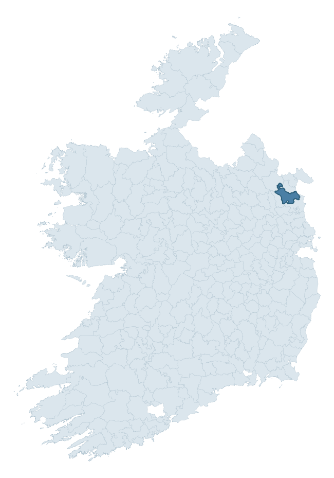
Where this barony sits in the Republic of Ireland
Geology and preservation
Bedrock geology shapes the landscape long before any settlement begins — controlling soil drainage, agricultural potential, the survival of upstanding monuments, and the preservation of buried archaeology. The figures below come from the Geological Survey Ireland 1:100,000 bedrock map.
The bedrock underlying Ardee is predominantly greywacke (54% of the barony by area), laid down during the Silurian period (84% by area, around 444 to 419 million years ago). Greywacke is a hard, dark, fine-grained sandstone that weathers to thin upland soils. Greywacke baronies typically carry sparser settlement archaeology but provide high-quality building stone visible in older field walls and farm buildings. A substantial secondary geology of greywacke, mudstone (29%) adds further variety to the underlying landscape. The single largest mapped unit is the Clontail Formation (54% of the barony's bedrock).
Rock type composition
Largest mapped unit: Clontail Formation (54% of the barony)
Placename evidence
Logainm records 30 heritage-diagnostic placenames for Ardee, drawn from townland and civil-parish names across the barony. The dominant stratum is pre-Christian and Early Medieval defensive — ráth-, lios-, dún-, and caiseal-prefixed names that mark Iron Age and early historic settlement. The leading diagnostic roots are ráth- (15 — earthen ringfort), cill- (6 — church), and lios- (4 — ringfort or enclosure). This is broadly in line with the ROI average of 30.7 heritage placenames per barony. Logainm records 212 placenames for Ardee (predominantly townland names). Of these, 30 (14%) carry one of the diagnostic Gaelic roots tracked above; the remainder draw on more generic landscape vocabulary that does not encode a heritage period.
Pre-Christian / Early Medieval Defensive
| Root | Count | Meaning |
|---|---|---|
| ráth- | 15 | earthen ringfort |
| lios- | 4 | ringfort or enclosure |
| dún- | 1 | hilltop or promontory fort |
| caiseal- | 1 | stone ringfort |
Early Christian Ecclesiastical
| Root | Count | Meaning |
|---|---|---|
| cill- | 6 | church (early) |
| cillín- | 2 | unconsecrated burial ground |
| tobar- | 1 | holy well |
Other baronies in Louth
- Ferrard
- Drogheda
- Duleek Lower
- Dundalk Upper
- Dundalk Lower
- Louth
- Brawny — Westmeath
- Maryborough East — Laois
- Moyfenrath Upper — Meath
- Carlow — Carlow
See all 280 baronies in the Republic of Ireland Heritage Tool.

Explore further
Grounding History: 10 Maps of Northern Ireland’s Past
If you’re interested in Irish heritage more widely, the companion report for Northern Ireland brings together the analysis of all 462 NI wards into one place through 10 high-quality maps — covering monument density, archaeological periods, placename heritage, terrain, wetland, and the historic landscape at first survey. Take a look.
About this profile
Click any section below to expand.
What is a barony?
A barony is a historic administrative unit in Ireland, broadly equivalent to an English hundred. The 280 baronies used here are from the OSi 2019 National Statutory Boundaries (generalised 20m), covering the 26 counties of the Republic of Ireland. Baronies derive from the Norman period, were formalised in the 17th century, and have not been redrawn for statistical purposes. They vary enormously in area, from compact urban baronies in Dublin to vast upland baronies in Connacht, and should not be compared by raw site count without accounting for area differences.
What counts as a site?
This profile combines three distinct heritage registers, each with its own definition of what constitutes a recordable site:
- Archaeological sites (NMS). The National Monuments Service Sites and Monuments Record (SMR) catalogues every known archaeological monument or site of archaeological interest in the Republic, from prehistoric burial mounds and ringforts to medieval churches and post-medieval defensive works. Inclusion does not require legal protection — only that the site has been identified, surveyed, and assessed as having archaeological value. A separate subset of these sites lies within a recorded protection zone, which gives them statutory protection under the National Monuments Acts.
- Listed buildings (NIAH). The National Inventory of Architectural Heritage records buildings of architectural, historical, archaeological, artistic, cultural, scientific, social, or technical interest. Each surveyed structure is appraised on a five-tier scale: International, National, Regional, Local, and Record-Only. The NIAH appraisal is informational rather than strictly statutory, but it underpins local-authority Record of Protected Structures (RPS) listings.
- Heritage placenames (Logainm). Logainm is the authoritative database of Irish placenames maintained by the Placenames Branch. This profile applies a heritage-diagnostic classifier to the Irish-language form of each townland name, flagging roots that signal defensive sites (ráth-, lios-, dún-, caiseal-, cathair-), ecclesiastical foundations (cill-, teampall-, domhnach-, mainistir-), prehistoric burial-ritual features (tuaim-, carn-, leaba-), or Norse-contact settlement (gall-). Townlands without one of these diagnostic roots are not flagged here — they may still carry historical significance, but that significance is not encoded in the name itself.
Editorial principles
The narrative sections of this profile follow several explicit principles:
- Evidential. Every claim about this barony’s heritage character is anchored in the underlying register data. Where a site count, a placename count, or a percentile rank is cited, it is computed from the source datasets at export time, not estimated.
- Comparative. Counts and metrics are reported alongside their percentile rank against the other 279 ROI baronies. A barony with 50 ringforts in absolute terms could be unusually high or unusually low depending on its size and regional context; percentile ranking removes that ambiguity.
- Transparent on limits. Where a register has known coverage gaps, survey biases, or data-quality issues that affect this barony’s figures, the profile flags them rather than presenting the numbers as definitive.
- No interpretation beyond what the data supports. The narrative does not speculate about historical events, social dynamics, or cultural meaning beyond what the recorded heritage and placename evidence directly attests.
Data caveats and limits
- NMS Sites and Monuments Record is the product of survey campaigns conducted at different intensities across different counties and decades. Some baronies have been surveyed more thoroughly than others, and absolute counts should be read in that light. Sites destroyed by development before survey are typically not represented; sites in heavily forested or upland terrain are sometimes under-recorded.
- NIAH coverage is broadly complete for the Republic of Ireland but the survey was conducted on a rolling county-by-county basis, and the most recent appraisal date varies. Buildings demolished or substantially altered after their original survey may still appear in the register; conversely, recent buildings of merit may not yet have been appraised.
- Logainm classification applies a deliberately conservative pattern-matching approach to the Irish-language townland forms. The classifier prioritises true positives over recall: a townland may carry a heritage signal that the classifier doesn’t recognise, particularly where the diagnostic root has been heavily anglicised or where the townland name draws on a less common term. The 60,000+ townland records and ~9,800 classified placenames give a substantial signal at barony scale, but individual townland names should be checked against Logainm directly for definitive interpretation.
- Period attribution. The chronological distribution reflects only those NMS sites that carry a recognised period attribution in the source data. Sites listed as “Unknown” period are excluded from the dated subset.
- Boundary changes. Some baronies have undergone minor boundary adjustments since their 19th-century definition; the OSi 2019 generalised boundaries used here are the current statutory definition and may differ slightly from historical maps in border areas.
- Bedrock geology is mapped at 1:100,000 scale, which means local variation within a barony — small pockets of different rock type, mineral veins, alluvium overlying bedrock — is generalised. The dominant-system and rocktype figures are area-weighted, so a barony reading “70% Carboniferous limestone” may still contain small but archaeologically important pockets of older or younger rock. Around 3% of GSI polygons do not match the lexicon and contribute no rocktype or system attribution.
Data sources
- National Monuments Service — Sites and Monuments Record (SMR) https://data.gov.ie/dataset/national-monuments-service-archaeological-survey-of-ireland
- National Inventory of Architectural Heritage (NIAH) https://data.gov.ie/dataset/national-inventory-of-architectural-heritage-niah-national-dataset
- Logainm — Placenames Database of Ireland https://www.logainm.ie/
- Ordnance Survey Ireland — National Statutory Barony Boundaries 2019 https://data-osi.opendata.arcgis.com/
- EURODEM — European Digital Elevation Model https://www.mapsforeurope.org/datasets/euro-dem
- ESA WorldCover https://esa-worldcover.org/en
- Geological Survey Ireland — 1:100,000 Bedrock Geology https://www.gsi.ie/en-ie/data-and-maps/Pages/Bedrock.aspx
Explore more: Search any of the 280 ROI baronies, browse by historical province, or read the methodology and data sources for the full Republic of Ireland Heritage Tool.