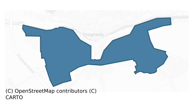
Duleek Lower is a barony of County Louth, in the historical province of Leinster (Irish: Damhliag Íochtarach), covering 5.3 km² of land. The barony records 5 NMS archaeological sites and 25 NIAH listed buildings, placing it at around the 11th percentile among 280 ROI baronies for sites per km². This means it is in the bottom fifth of all baronies for sites per km². Dated archaeological evidence runs from the Middle-Late Bronze Age through to the Early Medieval, spanning 2 of 9 archaeological periods, placing the barony in the 1st percentile among 280 ROI baronies for chronological depth. This means it is in the bottom tenth of all baronies for chronological depth. The largest dated subset of recorded sites dates to the Early Medieval.
Heritage at a glance
Percentile rankings throughout this profile compare each barony only against the other 279 Republic of Ireland baronies.
The recorded heritage of Duleek Lower
The National Monuments Service Sites and Monuments Record (SMR) is the statutory inventory of archaeological sites for the Republic of Ireland, maintained by the Department of Tourism, Culture, Arts, Gaeltacht, Sport and Media. Sites recorded here include earthworks, ringforts, megalithic tombs, ecclesiastical remains, and post-medieval features; not every record is legally protected, but each is registered as a monument of archaeological interest.
The National Monuments Service records 5 archaeological sites in Duleek Lower, putting it at the 11th percentile among 280 ROI baronies for sites per km². This means it is in the bottom fifth of all baronies for sites per km². A sparse recorded total of this kind in Ireland often reflects survey priority rather than genuine absence of past activity. Of these, 4 (80%) fall within a recorded monument protection zone. The record is dominated by burial and ritual monuments — barrows, cairns, and megalithic tombs (2 sites, 40% of the total), with ecclesiastical sites forming a substantial secondary presence (1 sites, 20%). Ritual site – holy well is the most prevalent type, making up 20% of the barony's recorded sites (1 records) — well above the ROI average of 3% across all baronies where this type occurs. Ritual site – holy well is a well or spring traditionally associated with a saint, often credited with healing properties; many trace earlier ritual origins but devotion is documented from the medieval period onwards. Other significant types include Burial ground (1) and Excavation – miscellaneous (1). Burial ground is an area set apart for burial that is not associated with a church, in use from the medieval period onwards.
Most common monument types
Hover or tap a monument type to see its definition.
| Type | Count |
|---|---|
| Ritual site – holy well a well or spring traditionally associated with a saint, often credited with healing properties; many trace earlier ritual origins but devotion is documented from the medieval period onwards | 1 |
| Burial ground an area set apart for burial that is not associated with a church, in use from the medieval period onwards | 1 |
| Excavation – miscellaneous | 1 |
| Mound an artificial earthen elevation of unknown date and function that cannot be classified as another known monument type | 1 |
| Field system a group of related fields forming a coherent agricultural landscape, of any date from the Neolithic onwards | 1 |
Chronological distribution
The dated archaeological record for Duleek Lower spans from the Middle-Late Bronze Age through to the Early Medieval, with activity attested across 2 of 9 archaeological periods. This is the 1st percentile across ROI baronies — a relatively narrow chronological band, with much of Irish prehistory not represented in the dated record. A further 3 recorded sites (60% of the overall NMS register for the barony) carry no period attribution — appearing as 'Unknown' in the bar chart below. This typically reflects either records that pre-date the standardised period vocabulary or sites awaiting specialist dating review, rather than a genuine absence of chronological evidence.
Sample of recorded monuments
Show all 5 recorded monuments
All 5 recorded monuments in the barony. Each entry shows the official Sites and Monuments Record reference number and the description published by the National Monuments Service.
Ritual site – holy well
Marked on the 1835 'OS 6-inch' map as 'St. Patrick's Well' and the 1938 ed. as 'St. Patrick's Well (site of)'. Isaac Butler refers to this well in his Journal of 1744 (CLAJ 1922, 96). All visible remains were removed…
Marked on the 1835 'OS 6-inch' map as 'St. Patrick's Well' and the 1938 ed. as 'St. Patrick's Well (site of)'. Isaac Butler refers to this well in his Journal of 1744 (CLAJ 1922, 96). All visible remains were removed sometime in the mid 19th century (Bassett 1886, 79).
Compiled by: Claire Breen
Date of upload: 28 August 2012
Burial ground
Triangular shaped enclosed area marked 'Burial Gd' on the 1938 'OS 6-inch' map (map dims. 125m x 105m x 103m) with 'Calvery Cemetery' adjoining it to the E. Referred to as 'the pauper's graveyard' in the 1930's (IFC…
Triangular shaped enclosed area marked 'Burial Gd' on the 1938 'OS 6-inch' map (map dims. 125m x 105m x 103m) with 'Calvery Cemetery' adjoining it to the E. Referred to as 'the pauper's graveyard' in the 1930's (IFC Schools' Mss 679, 338).
Compiled by: Claire Breen
Date of upload: 28 August 2012
Mound
The following description is derived from both the published 'Archaeological Inventory of County Louth' (Dublin: Stationery Office, 1986) and the 'Archaeological Survey of County Louth' (Dublin: Stationery Office,…
The following description is derived from both the published 'Archaeological Inventory of County Louth' (Dublin: Stationery Office, 1986) and the 'Archaeological Survey of County Louth' (Dublin: Stationery Office, 1991). In certain instances the entries have been revised and updated in the light of recent research.
Date of upload/revision: 17 July 2007
Situated in a field on the S outskirts of Drogheda. Circular mound (max. diam. c. 35m, H 4m) truncated to the N by a modern laneway and to the W by a paddock. The mound bears the popular title of 'Cromwell's Mount' and is traditionally the site of a Cromwellian artillery bastion (Buckley 1986a, 99). However, the site is shown as a cairn with external fosse on the 1835 ed. of the OS 6-inch map. Owing to its prominent position with extensive views over the River Boyne to the N, coupled with its unlikely strategic value as an artillery bastion, this site has been reclassified as either a barrow or a denuded passage grave.
Field system
The Archaeological Survey of Ireland (ASI) is in the process of providing information on all monuments on The Historic Environment Viewer (HEV). Currently the information for this record has not been uploaded. To…
The Archaeological Survey of Ireland (ASI) is in the process of providing information on all monuments on The Historic Environment Viewer (HEV). Currently the information for this record has not been uploaded. To access available information for research purposes please make an appointment in advance with the Archive Unit (open Fridays 10.00 am – 5.00 pm), Department of Culture, Heritage and the Gaeltacht, The Custom House, Dublin 1 D01W6XO or email nmarchive@chg.gov.ie.
Excavation – miscellaneous
Two pits cut into subsoil and an associated metalled surface were uncovered here during archaeological monitoring of drainage works (Excavation Licence No. 00E0629). No finds were recovered from these features but a…
Two pits cut into subsoil and an associated metalled surface were uncovered here during archaeological monitoring of drainage works (Excavation Licence No. 00E0629). No finds were recovered from these features but a barbed and tanged arrowhead and a sherd of blackware pottery were found on the surface beside the pits. (O' Brien 2002, 221-2)
Compiled by: Claire Breen
Date of upload: 03 July 2013
Listed buildings
The National Inventory of Architectural Heritage (NIAH) is a state survey appraising buildings of architectural, historical, archaeological, artistic, cultural, scientific, social, or technical interest. Each surveyed structure receives a rating from International (the highest, for buildings of European importance) through National, Regional, Local, and Record-Only.
The NIAH records only 25 listed buildings in Duleek Lower, the 11th percentile across ROI baronies — a relatively thin architectural record. All recorded buildings carry Regional or lower grading; the barony does not contain any structures appraised as being of National or International architectural importance. Construction dates concentrate most heavily in the Victorian (1830-1900) period. The most-recorded building type is worker's house (14 examples, 56% of the listed stock).
Terrain and environment
Mean elevation across the barony is 31m — the 6th percentile among 280 ROI baronies for elevation. This means it is in the bottom tenth of all baronies for elevation. This is a relatively low-lying landscape by ROI standards. Elevation matters for heritage because higher-altitude baronies typically favour defensive monuments — ringforts and hilltop forts placed on prominent ground — while lowland baronies are more likely to carry the dense settlement and church networks of intensive agricultural landscapes. Mean slope is 3.3° — the 44th percentile among 280 ROI baronies for slope. This means it is in the lower half of all baronies for slope. Slope is a key control on both land use and archaeological preservation: steep ground resists ploughing and tends to preserve earthworks intact, while gentle slopes favour intensive cultivation that damages or destroys surface archaeology over time. The Topographic Wetness Index averages 11.1, the 60th percentile among 280 ROI baronies for wetness. This means it is in the upper half of all baronies for wetness. Drainage matters for heritage because poorly-drained ground preserves organic archaeology (wooden trackways, leather, textiles, and on rare occasions human remains) far better than free-draining soil; well-drained ground favours arable use but destroys organic material rapidly. Urban land covers 38% of the barony (the 100th percentile among 280 ROI baronies for urban cover. This means it is in the top tenth of all baronies for urban cover). Heavy urban coverage compresses heritage analysis: many archaeological features have been buried or destroyed by development, but the surviving record is concentrated in protected city-centre cores, and the NIAH listed-buildings count is typically high. The land-cover mosaic combines urban land (38%), improved grassland (29%), and woodland (25%), giving a mixed agricultural and semi-natural landscape.
Terrain measurements
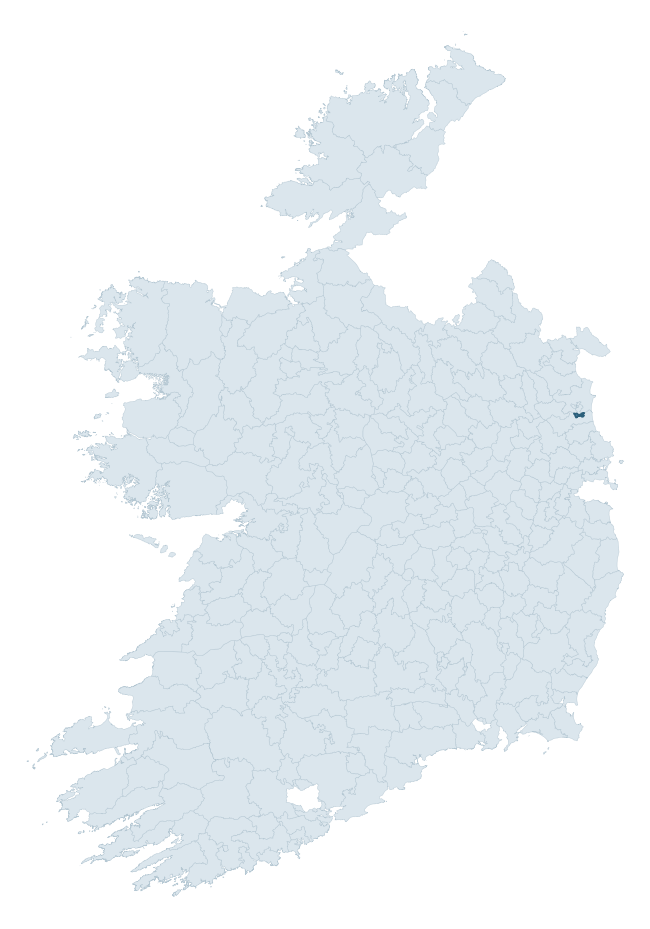
Where this barony sits in the Republic of Ireland
Geology and preservation
Bedrock geology shapes the landscape long before any settlement begins — controlling soil drainage, agricultural potential, the survival of upstanding monuments, and the preservation of buried archaeology. The figures below come from the Geological Survey Ireland 1:100,000 bedrock map.
The bedrock underlying Duleek Lower is predominantly limestone (98% of the barony by area), laid down during the Carboniferous period (98% by area, around 359 to 299 million years ago). Limestone is the most heritage-rich bedrock in Ireland. It supports fertile, well-drained soils that favoured dense Early Medieval settlement and Norman manorial agriculture, and it weathers into karst features — sinkholes, caves, swallow holes, and souterrains — that frequently carry archaeology. Where peat overlies limestone, organic preservation can be exceptional. The single largest mapped unit is the Mornington Formation (50% of the barony's bedrock). With only 2 distinct rock types mapped, the barony is geologically uniform compared to the rest of the Republic (17th percentile for diversity) — a single coherent bedrock landscape.
Rock type composition
Largest mapped unit: Mornington Formation (50% of the barony)
Placename evidence
The Logainm record for Duleek Lower contains only 2 heritage-diagnostic placenames — 1 ráth-name and 1 dún-name. With this few records, the count should be read as indicative rather than as a firm characterisation of the linguistic heritage layers; a larger sample would be needed to reliably distinguish defensive, ecclesiastical, or other stratigraphic signals from chance occurrence.
Pre-Christian / Early Medieval Defensive
| Root | Count | Meaning |
|---|---|---|
| ráth- | 1 | earthen ringfort |
| dún- | 1 | hilltop or promontory fort |
Other baronies in Louth
- Ferrard
- Drogheda
- Ardee
- Louth
- Dundalk Upper
- Dundalk Lower
- Naas South — Kildare
- Narragh And Reban East — Kildare
- Crannagh — Kilkenny
- Upperwoods — Laois
See all 280 baronies in the Republic of Ireland Heritage Tool.

Explore further
Grounding History: 10 Maps of Northern Ireland’s Past
If you’re interested in Irish heritage more widely, the companion report for Northern Ireland brings together the analysis of all 462 NI wards into one place through 10 high-quality maps — covering monument density, archaeological periods, placename heritage, terrain, wetland, and the historic landscape at first survey. Take a look.
About this profile
Click any section below to expand.
What is a barony?
A barony is a historic administrative unit in Ireland, broadly equivalent to an English hundred. The 280 baronies used here are from the OSi 2019 National Statutory Boundaries (generalised 20m), covering the 26 counties of the Republic of Ireland. Baronies derive from the Norman period, were formalised in the 17th century, and have not been redrawn for statistical purposes. They vary enormously in area, from compact urban baronies in Dublin to vast upland baronies in Connacht, and should not be compared by raw site count without accounting for area differences.
What counts as a site?
This profile combines three distinct heritage registers, each with its own definition of what constitutes a recordable site:
- Archaeological sites (NMS). The National Monuments Service Sites and Monuments Record (SMR) catalogues every known archaeological monument or site of archaeological interest in the Republic, from prehistoric burial mounds and ringforts to medieval churches and post-medieval defensive works. Inclusion does not require legal protection — only that the site has been identified, surveyed, and assessed as having archaeological value. A separate subset of these sites lies within a recorded protection zone, which gives them statutory protection under the National Monuments Acts.
- Listed buildings (NIAH). The National Inventory of Architectural Heritage records buildings of architectural, historical, archaeological, artistic, cultural, scientific, social, or technical interest. Each surveyed structure is appraised on a five-tier scale: International, National, Regional, Local, and Record-Only. The NIAH appraisal is informational rather than strictly statutory, but it underpins local-authority Record of Protected Structures (RPS) listings.
- Heritage placenames (Logainm). Logainm is the authoritative database of Irish placenames maintained by the Placenames Branch. This profile applies a heritage-diagnostic classifier to the Irish-language form of each townland name, flagging roots that signal defensive sites (ráth-, lios-, dún-, caiseal-, cathair-), ecclesiastical foundations (cill-, teampall-, domhnach-, mainistir-), prehistoric burial-ritual features (tuaim-, carn-, leaba-), or Norse-contact settlement (gall-). Townlands without one of these diagnostic roots are not flagged here — they may still carry historical significance, but that significance is not encoded in the name itself.
Editorial principles
The narrative sections of this profile follow several explicit principles:
- Evidential. Every claim about this barony’s heritage character is anchored in the underlying register data. Where a site count, a placename count, or a percentile rank is cited, it is computed from the source datasets at export time, not estimated.
- Comparative. Counts and metrics are reported alongside their percentile rank against the other 279 ROI baronies. A barony with 50 ringforts in absolute terms could be unusually high or unusually low depending on its size and regional context; percentile ranking removes that ambiguity.
- Transparent on limits. Where a register has known coverage gaps, survey biases, or data-quality issues that affect this barony’s figures, the profile flags them rather than presenting the numbers as definitive.
- No interpretation beyond what the data supports. The narrative does not speculate about historical events, social dynamics, or cultural meaning beyond what the recorded heritage and placename evidence directly attests.
Data caveats and limits
- NMS Sites and Monuments Record is the product of survey campaigns conducted at different intensities across different counties and decades. Some baronies have been surveyed more thoroughly than others, and absolute counts should be read in that light. Sites destroyed by development before survey are typically not represented; sites in heavily forested or upland terrain are sometimes under-recorded.
- NIAH coverage is broadly complete for the Republic of Ireland but the survey was conducted on a rolling county-by-county basis, and the most recent appraisal date varies. Buildings demolished or substantially altered after their original survey may still appear in the register; conversely, recent buildings of merit may not yet have been appraised.
- Logainm classification applies a deliberately conservative pattern-matching approach to the Irish-language townland forms. The classifier prioritises true positives over recall: a townland may carry a heritage signal that the classifier doesn’t recognise, particularly where the diagnostic root has been heavily anglicised or where the townland name draws on a less common term. The 60,000+ townland records and ~9,800 classified placenames give a substantial signal at barony scale, but individual townland names should be checked against Logainm directly for definitive interpretation.
- Period attribution. The chronological distribution reflects only those NMS sites that carry a recognised period attribution in the source data. Sites listed as “Unknown” period are excluded from the dated subset.
- Boundary changes. Some baronies have undergone minor boundary adjustments since their 19th-century definition; the OSi 2019 generalised boundaries used here are the current statutory definition and may differ slightly from historical maps in border areas.
- Bedrock geology is mapped at 1:100,000 scale, which means local variation within a barony — small pockets of different rock type, mineral veins, alluvium overlying bedrock — is generalised. The dominant-system and rocktype figures are area-weighted, so a barony reading “70% Carboniferous limestone” may still contain small but archaeologically important pockets of older or younger rock. Around 3% of GSI polygons do not match the lexicon and contribute no rocktype or system attribution.
Data sources
- National Monuments Service — Sites and Monuments Record (SMR) https://data.gov.ie/dataset/national-monuments-service-archaeological-survey-of-ireland
- National Inventory of Architectural Heritage (NIAH) https://data.gov.ie/dataset/national-inventory-of-architectural-heritage-niah-national-dataset
- Logainm — Placenames Database of Ireland https://www.logainm.ie/
- Ordnance Survey Ireland — National Statutory Barony Boundaries 2019 https://data-osi.opendata.arcgis.com/
- EURODEM — European Digital Elevation Model https://www.mapsforeurope.org/datasets/euro-dem
- ESA WorldCover https://esa-worldcover.org/en
- Geological Survey Ireland — 1:100,000 Bedrock Geology https://www.gsi.ie/en-ie/data-and-maps/Pages/Bedrock.aspx
Explore more: Search any of the 280 ROI baronies, browse by historical province, or read the methodology and data sources for the full Republic of Ireland Heritage Tool.