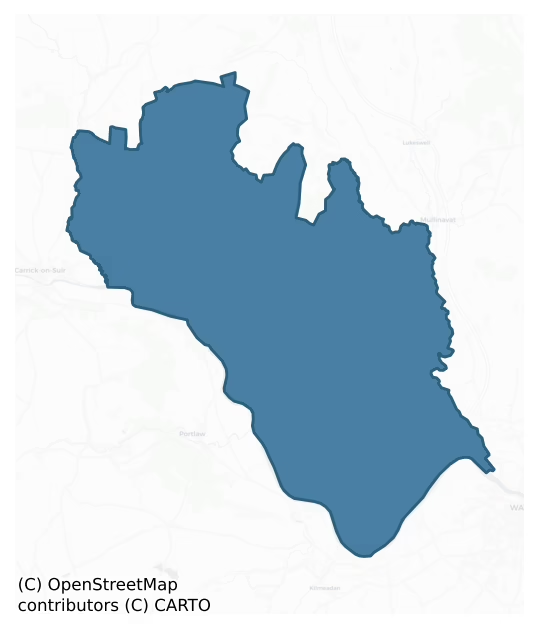
Iverk is a barony of County Kilkenny, in the historical province of Leinster (Irish: Uíbh Eirc), covering 167 km² of land. The barony records 245 NMS archaeological sites and 179 NIAH listed buildings, placing it at around the 31st percentile among 280 ROI baronies for sites per km². This means it is in the bottom third of all baronies for sites per km². Dated archaeological evidence runs from the Neolithic through to the Post Medieval, spanning 7 of 9 archaeological periods, placing the barony in the 30th percentile among 280 ROI baronies for chronological depth. This means it is in the bottom third of all baronies for chronological depth. The largest dated subset of recorded sites dates to the Early Medieval. Logainm flags 24 placenames in the barony as carrying a recognised heritage root; the largest share — around 58% — are names associated with early Christian church and monastic foundations.
Heritage at a glance
Percentile rankings throughout this profile compare each barony only against the other 279 Republic of Ireland baronies.
The recorded heritage of Iverk
The National Monuments Service Sites and Monuments Record (SMR) is the statutory inventory of archaeological sites for the Republic of Ireland, maintained by the Department of Tourism, Culture, Arts, Gaeltacht, Sport and Media. Sites recorded here include earthworks, ringforts, megalithic tombs, ecclesiastical remains, and post-medieval features; not every record is legally protected, but each is registered as a monument of archaeological interest.
The National Monuments Service records 245 archaeological sites in Iverk, putting it at the 31st percentile among 280 ROI baronies for sites per km². This means it is in the bottom third of all baronies for sites per km². Protection coverage is near-universal — 241 sites (98%) fall within a recorded monument protection zone, indicating an extensively surveyed landscape. The record is dominated by ecclesiastical sites — churches, graveyards, and holy wells (71 sites, 29% of the total), with defensive sites forming a substantial secondary presence (66 sites, 27%). Fulacht fia is the most prevalent type, making up 18% of the barony's recorded sites (45 records) — well above the ROI average of 6% across all baronies where this type occurs. Fulacht fia is a horseshoe-shaped Bronze Age burnt mound built around a sunken trough beside a water source, traditionally interpreted as a cooking site. Other significant types include Church (22) and Graveyard (21). Church is a building used for public Christian worship, of any date from c. 500 AD onwards; Graveyard is a burial area associated with a church, in use from the medieval period onwards. Across the barony's 167 km², this gives a recorded density of 1.46 sites per km².
Most common monument types
Hover or tap a monument type to see its definition.
| Type | Count |
|---|---|
| Fulacht fia a horseshoe-shaped Bronze Age burnt mound built around a sunken trough beside a water source, traditionally interpreted as a cooking site | 45 |
| Church a building used for public Christian worship, of any date from c. 500 AD onwards | 22 |
| Graveyard a burial area associated with a church, in use from the medieval period onwards | 21 |
| Ringfort – rath an earthen ringfort enclosed by a bank and external ditch — the most common Early Medieval farmstead, broadly dated 500–1000 AD | 18 |
| Enclosure a banked or ditched feature of uncertain type, used as a catch-all where the original function cannot be determined from surface evidence | 15 |
| Ritual site – holy well a well or spring traditionally associated with a saint, often credited with healing properties; many trace earlier ritual origins but devotion is documented from the medieval period onwards | 12 |
| Bullaun stone a boulder or rock outcrop with hemispherical hollows ('bulláin'), commonly associated with ecclesiastical sites and holy wells | 9 |
| Castle – unclassified a castle whose form cannot be precisely classified, dating somewhere between the late 12th and 16th centuries | 9 |
Chronological distribution
The dated archaeological record for Iverk spans from the Neolithic through to the Post Medieval, with activity attested across 7 of 9 archaeological periods. Every period from earliest to latest is represented in the record — an unbroken sequence of dated activity across the full chronological span. Activity concentrates most heavily in the Early Medieval (58 sites, 37% of dated material), with the Middle Late Bronze Age forming a secondary peak (46 sites, 29%). A further 88 recorded sites (36% of the overall NMS register for the barony) carry no period attribution — appearing as 'Unknown' in the bar chart below. This typically reflects either records that pre-date the standardised period vocabulary or sites awaiting specialist dating review, rather than a genuine absence of chronological evidence.
Sample of recorded monuments
Show 25 sample monuments (of 245 total)
A representative sample of 25 recorded monuments drawn from the barony’s 245 total NMS entries. Sites within a recorded monument protection zone and rarer site types are prioritised so the list shows a meaningful cross-section rather than only the most common type. Each entry shows the official Sites and Monuments Record reference number and the description published by the National Monuments Service.
Ecclesiastical enclosure
On the lower S-facing slope of Kilmacoliver Hill, overlooking the valley of the River Suir. The medieval church and graveyard (KK034-032002-) are located on the site of an early medieval monastery, as evidenced by four…
On the lower S-facing slope of Kilmacoliver Hill, overlooking the valley of the River Suir. The medieval church and graveyard (KK034-032002-) are located on the site of an early medieval monastery, as evidenced by four high crosses (KK034-032004-; KK034-032005-; KK034-032006-; KK034-032007-) within the graveyard. An archaeological excavation within the N sector of the graveyard in 1985 (Hurley 1988, 124-34) revealed a wall (Wth 1.5-2m; H 0.2-0.9m) one to two courses high. The wall extended E-W in a gradually curving arc (ibid. 126). The wall was faced internally and externally with dry-stone walling and the interior was filled with rubble and large boulders (ibid. 126, 129). The wall was not removed but it appeared to be set on boulder clay which was at a higher level than the boulder clay within the enclosure, suggesting that the raised area under the wall may have been a natural terrace or a pre-existing clay bank (ibid. 129). It was not established whether the wall and possible bank were associated with the monastery or were later medieval features (ibid.).
Compiled by: Jean Farrelly
Date of upload: 20 August 2018
House – 17th century
The Archaeological Survey of Ireland (ASI) is in the process of providing information on all monuments on The Historic Environment Viewer (HEV). Currently the information for this record has not been uploaded. To…
The Archaeological Survey of Ireland (ASI) is in the process of providing information on all monuments on The Historic Environment Viewer (HEV). Currently the information for this record has not been uploaded. To access available information for research purposes please make an appointment in advance with the Archive Unit (open Fridays 10.00 am – 5.00 pm), Department of Culture, Heritage and the Gaeltacht, The Custom House, Dublin 1 D01W6XO or email nmarchive@chg.gov.ie.
Earthwork
The Archaeological Survey of Ireland (ASI) is in the process of providing information on all monuments on The Historic Environment Viewer (HEV). Currently the information for this record has not been uploaded. To…
The Archaeological Survey of Ireland (ASI) is in the process of providing information on all monuments on The Historic Environment Viewer (HEV). Currently the information for this record has not been uploaded. To access available information for research purposes please make an appointment in advance with the Archive Unit (open Fridays 10.00 am – 5.00 pm), Department of Culture, Heritage and the Gaeltacht, The Custom House, Dublin 1 D01W6XO or email nmarchive@chg.gov.ie.
Graveslab (present location)
The Archaeological Survey of Ireland (ASI) is in the process of providing information on all monuments on The Historic Environment Viewer (HEV). Currently the information for this record has not been uploaded. To…
The Archaeological Survey of Ireland (ASI) is in the process of providing information on all monuments on The Historic Environment Viewer (HEV). Currently the information for this record has not been uploaded. To access available information for research purposes please make an appointment in advance with the Archive Unit (open Fridays 10.00 am – 5.00 pm), Department of Culture, Heritage and the Gaeltacht, The Custom House, Dublin 1 D01W6XO or email nmarchive@chg.gov.ie.
Font (present location)
The Archaeological Survey of Ireland (ASI) is in the process of providing information on all monuments on The Historic Environment Viewer (HEV). Currently the information for this record has not been uploaded. To…
The Archaeological Survey of Ireland (ASI) is in the process of providing information on all monuments on The Historic Environment Viewer (HEV). Currently the information for this record has not been uploaded. To access available information for research purposes please make an appointment in advance with the Archive Unit (open Fridays 10.00 am – 5.00 pm), Department of Culture, Heritage and the Gaeltacht, The Custom House, Dublin 1 D01W6XO or email nmarchive@chg.gov.ie.
Hut site
The Archaeological Survey of Ireland (ASI) is in the process of providing information on all monuments on The Historic Environment Viewer (HEV). Currently the information for this record has not been uploaded. To…
The Archaeological Survey of Ireland (ASI) is in the process of providing information on all monuments on The Historic Environment Viewer (HEV). Currently the information for this record has not been uploaded. To access available information for research purposes please make an appointment in advance with the Archive Unit (open Fridays 10.00 am – 5.00 pm), Department of Culture, Heritage and the Gaeltacht, The Custom House, Dublin 1 D01W6XO or email nmarchive@chg.gov.ie.
House – medieval
The Archaeological Survey of Ireland (ASI) is in the process of providing information on all monuments on The Historic Environment Viewer (HEV). Currently the information for this record has not been uploaded. To…
The Archaeological Survey of Ireland (ASI) is in the process of providing information on all monuments on The Historic Environment Viewer (HEV). Currently the information for this record has not been uploaded. To access available information for research purposes please make an appointment in advance with the Archive Unit (open Fridays 10.00 am – 5.00 pm), Department of Culture, Heritage and the Gaeltacht, The Custom House, Dublin 1 D01W6XO or email nmarchive@chg.gov.ie.
Well
The Archaeological Survey of Ireland (ASI) is in the process of providing information on all monuments on The Historic Environment Viewer (HEV). Currently the information for this record has not been uploaded. To…
The Archaeological Survey of Ireland (ASI) is in the process of providing information on all monuments on The Historic Environment Viewer (HEV). Currently the information for this record has not been uploaded. To access available information for research purposes please make an appointment in advance with the Archive Unit (open Fridays 10.00 am – 5.00 pm), Department of Culture, Heritage and the Gaeltacht, The Custom House, Dublin 1 D01W6XO or email nmarchive@chg.gov.ie.
Barrow – ring-barrow
The Archaeological Survey of Ireland (ASI) is in the process of providing information on all monuments on The Historic Environment Viewer (HEV). Currently the information for this record has not been uploaded. To…
The Archaeological Survey of Ireland (ASI) is in the process of providing information on all monuments on The Historic Environment Viewer (HEV). Currently the information for this record has not been uploaded. To access available information for research purposes please make an appointment in advance with the Archive Unit (open Fridays 10.00 am – 5.00 pm), Department of Culture, Heritage and the Gaeltacht, The Custom House, Dublin 1 D01W6XO or email nmarchive@chg.gov.ie.
Stone circle
The Archaeological Survey of Ireland (ASI) is in the process of providing information on all monuments on The Historic Environment Viewer (HEV). Currently the information for this record has not been uploaded. To…
The Archaeological Survey of Ireland (ASI) is in the process of providing information on all monuments on The Historic Environment Viewer (HEV). Currently the information for this record has not been uploaded. To access available information for research purposes please make an appointment in advance with the Archive Unit (open Fridays 10.00 am – 5.00 pm), Department of Culture, Heritage and the Gaeltacht, The Custom House, Dublin 1 D01W6XO or email nmarchive@chg.gov.ie.
Wall monument
A mural tablet with an English inscription in Roman script commemorating Sir John Ponsonby of Bessborough, kt. The tablet is dated 1668. (Cockerham 2009, 361)
Compiled by: Mary Tunney
Date of upload: 27 May 2013
Penal Mass station
On a slight SE-facing slope in a large pasture field. Local information that people came to an old building in this field when Owning chapel was ‘closed against the priest and people’ (a reference to Carrigan 1905).…
On a slight SE-facing slope in a large pasture field. Local information that people came to an old building in this field when Owning chapel was ‘closed against the priest and people’ (a reference to Carrigan 1905). Location identified by a local informant. Not visible at ground level.
Compiled by: Mary Tunney
Date of upload: 26 June 2013
Bawn
The castle, constructed of limestone rubble roughly coursed, consists of a square bawn (dims. 30m; wall T 2.2m) defended on the river side with a circular tower at the SE and SW angles, though only the foundations of…
The castle, constructed of limestone rubble roughly coursed, consists of a square bawn (dims. 30m; wall T 2.2m) defended on the river side with a circular tower at the SE and SW angles, though only the foundations of the SE tower survive. The internal buildings including a NE tower, hall and SE tower (KK043-034001-) are located along the N wall of the bawn. The E bawn wall survives to a height of 3.8m. There is a further circular tower to the W, connected to the SW angle tower by a thin wall, which indicates that there was probably an outer bawn to the W. The bawn has a base-batter which is more pronounced along the S river side (H 3m; Wth c. 0.4m) than on the N and E sides (H 2m; Wth 0.3m), though it becomes more pronounced adjacent to the entrance in the E wall. The N and E bawn wall and the S wall of the NE angle tower were strengthened by a series of relieving arches (H 0.2-0.4m in E wall to 1.2m in N wall; Wth 0.87-2.13m, with an average Wth 1.33m) at the base of the wall, some quite pointed. Similar relieving arches were employed at the bawn of Ormond Castle. The buildings occupied the N wall of the bawn, with a rectangular tower house in the NE angle, a building with a circular tower at the NW angle and a hall between the two.
The SE angle tower of the bawn is almost complete gone, with only portion of the curving wall of the ground-floor surviving. It is depicted on Hooper’s 1791 sketch (Grose 1791, vol. 2, pl. 31), as a four-storey tower with a cross-loop at gr…
Castle – motte
The Archaeological Survey of Ireland (ASI) is in the process of providing information on all monuments on The Historic Environment Viewer (HEV). Currently the information for this record has not been uploaded. To…
The Archaeological Survey of Ireland (ASI) is in the process of providing information on all monuments on The Historic Environment Viewer (HEV). Currently the information for this record has not been uploaded. To access available information for research purposes please make an appointment in advance with the Archive Unit (open Fridays 10.00 am – 5.00 pm), Department of Culture, Heritage and the Gaeltacht, The Custom House, Dublin 1 D01W6XO or email nmarchive@chg.gov.ie.
Megalithic tomb – wedge tomb
Approximately 7m N of a motte (KK035-038—-) on a level shoulder on the E side and at the head of a narrow river valley that runs between the two hills N of Owning. Carrigan (1905, vol. 2, 249) describes it as being…
Approximately 7m N of a motte (KK035-038—-) on a level shoulder on the E side and at the head of a narrow river valley that runs between the two hills N of Owning. Carrigan (1905, vol. 2, 249) describes it as being '17ft. [c. 5m] long and about 3ft. [c. 0.9m] wide. Some of the stones are in situ, others fallen, but lying as they fell. . . now generally called the "Giant's Grave"'. The monument was destroyed between 1974 and 1982. Only an E end stone and adjoining N sidestone of a gallery remained in 1974. Two orthostats stood immediately N of this and formed a doubling of the gallery wall. It would seem probable that the monument was a megalithic tomb and interpretation of the remains as the E end of a wedge tomb gallery would not be inconsistent with the evidence. (Prendergast 1967, 91; O'Kelly 1969, 132 (under Curraghmore))
Compiled by: Paul Walsh
Date of upload: 12 May 2021
Castle – motte and bailey
This is one of three ‘castles’ erected by Prince John in 1185 (AFM, iii, 67); the other two castles being Ardfinnan (TS088-001001-) and Lismore (WA021-019001-). These were erected to provide a fortified border between…
This is one of three ‘castles’ erected by Prince John in 1185 (AFM, iii, 67); the other two castles being Ardfinnan (TS088-001001-) and Lismore (WA021-019001-). These were erected to provide a fortified border between his demesne land in Waterford and the frontier lands in Leinster, the midlands and Munster, most especially the kingdoms of Mac Carthaigh in Desmond and Ó Briain in Thomond. Domhnall Mór Ó Briain, king of Thomond, rightly viewed these newly erected castles as a threat to his lordship and the garrison at Tibberaghny was attacked by his ‘men of Limerick’ on 24 June of that year where ‘the death of the noble Irishman Oggravus along with many others…’ is recorded (Scott and Martin 1978, 351-2). The Annals of Lough Cé note that ‘Ruaidhri O’Gradha and Ruaidhri O’Conaing were slain by Foreigners in the slaughter of the castle of Tipraid-Fachtna.’ (Hennessy 1871, 171). In this attack, it would appear that the Anglo-Normans were victorious. This castle is not mentioned again in the historical documents.
The motte was described by Orpen (1909, 324) as ‘about 30 feet [9.15m] high, with flat, circular top, 18 paces in diameter. The bailey appears to have been mainly towards the north, following the shape of the rising ground, with faint traces of a levelled fosse and vallum. Probably these originally joined the mote-fosse and vallum at the south-east and south-west corners, so as to include the mote.’ This monument was levelled in the 1970s (SMR file).
Compiled by…
Castle – motte
The Archaeological Survey of Ireland (ASI) is in the process of providing information on all monuments on The Historic Environment Viewer (HEV). Currently the information for this record has not been uploaded. To…
The Archaeological Survey of Ireland (ASI) is in the process of providing information on all monuments on The Historic Environment Viewer (HEV). Currently the information for this record has not been uploaded. To access available information for research purposes please make an appointment in advance with the Archive Unit (open Fridays 10.00 am – 5.00 pm), Department of Culture, Heritage and the Gaeltacht, The Custom House, Dublin 1 D01W6XO or email nmarchive@chg.gov.ie.
Architectural fragment
The Archaeological Survey of Ireland (ASI) is in the process of providing information on all monuments on The Historic Environment Viewer (HEV). Currently the information for this record has not been uploaded. To…
The Archaeological Survey of Ireland (ASI) is in the process of providing information on all monuments on The Historic Environment Viewer (HEV). Currently the information for this record has not been uploaded. To access available information for research purposes please make an appointment in advance with the Archive Unit (open Fridays 10.00 am – 5.00 pm), Department of Culture, Heritage and the Gaeltacht, The Custom House, Dublin 1 D01W6XO or email nmarchive@chg.gov.ie.
Castle – motte and bailey
The Archaeological Survey of Ireland (ASI) is in the process of providing information on all monuments on The Historic Environment Viewer (HEV). Currently the information for this record has not been uploaded. To…
The Archaeological Survey of Ireland (ASI) is in the process of providing information on all monuments on The Historic Environment Viewer (HEV). Currently the information for this record has not been uploaded. To access available information for research purposes please make an appointment in advance with the Archive Unit (open Fridays 10.00 am – 5.00 pm), Department of Culture, Heritage and the Gaeltacht, The Custom House, Dublin 1 D01W6XO or email nmarchive@chg.gov.ie.
Megalithic tomb – wedge tomb
The Archaeological Survey of Ireland (ASI) is in the process of providing information on all monuments on The Historic Environment Viewer (HEV). Currently the information for this record has not been uploaded. To…
The Archaeological Survey of Ireland (ASI) is in the process of providing information on all monuments on The Historic Environment Viewer (HEV). Currently the information for this record has not been uploaded. To access available information for research purposes please make an appointment in advance with the Archive Unit (open Fridays 10.00 am – 5.00 pm), Department of Culture, Heritage and the Gaeltacht, The Custom House, Dublin 1 D01W6XO or email nmarchive@chg.gov.ie.
Settlement deserted – medieval
On the lower S-facing slope of Kilmacoliver Hill, overlooking the valley of the River Suir. The medieval church and graveyard (KK034-032002-) are located on the site of an early medieval monastery, as evidenced by four…
On the lower S-facing slope of Kilmacoliver Hill, overlooking the valley of the River Suir. The medieval church and graveyard (KK034-032002-) are located on the site of an early medieval monastery, as evidenced by four high crosses (KK034-032004-; KK034-032005-; KK034-032006-; KK034-032007-) within the graveyard. An archaeological excavation within the graveyard in 1985 (Hurley 1988, 124-34) revealed a wall and possible bank beneath it which may have been the ecclesiastical enclosure (KK034-032011-). Enclosed by this wall there was a layer of organically-enriched soil with associated medieval pottery which the excavator interpreted as a possible occupation layer (ibid. 130). Also revealed were a slot trench and post holes (ibid.).
Compiled by: Jean Farrelly
Date of upload: 20 August 2018
Mound
The Archaeological Survey of Ireland (ASI) is in the process of providing information on all monuments on The Historic Environment Viewer (HEV). Currently the information for this record has not been uploaded. To…
The Archaeological Survey of Ireland (ASI) is in the process of providing information on all monuments on The Historic Environment Viewer (HEV). Currently the information for this record has not been uploaded. To access available information for research purposes please make an appointment in advance with the Archive Unit (open Fridays 10.00 am – 5.00 pm), Department of Culture, Heritage and the Gaeltacht, The Custom House, Dublin 1 D01W6XO or email nmarchive@chg.gov.ie.
Fulacht fia
The Archaeological Survey of Ireland (ASI) is in the process of providing information on all monuments on The Historic Environment Viewer (HEV). Currently the information for this record has not been uploaded. To…
The Archaeological Survey of Ireland (ASI) is in the process of providing information on all monuments on The Historic Environment Viewer (HEV). Currently the information for this record has not been uploaded. To access available information for research purposes please make an appointment in advance with the Archive Unit (open Fridays 10.00 am – 5.00 pm), Department of Culture, Heritage and the Gaeltacht, The Custom House, Dublin 1 D01W6XO or email nmarchive@chg.gov.ie.
Listed buildings
The National Inventory of Architectural Heritage (NIAH) is a state survey appraising buildings of architectural, historical, archaeological, artistic, cultural, scientific, social, or technical interest. Each surveyed structure receives a rating from International (the highest, for buildings of European importance) through National, Regional, Local, and Record-Only.
The NIAH records 179 listed buildings in Iverk, the 73rd percentile across ROI baronies for listed-building density. Among these, 6 are graded National — buildings of interest to the whole of Ireland rather than only its region. The Republic holds 937 National-graded buildings in total, so this barony accounts for around 1% of the national total. Construction dates concentrate most heavily in the Late Georgian (1800-1830) period. The most-recorded building type is house (55 examples, 31% of the listed stock).
Terrain and environment
Mean elevation across the barony is 64m — the 25th percentile among 280 ROI baronies for elevation. This means it is in the bottom third of all baronies for elevation. This is a relatively low-lying landscape by ROI standards. Elevation matters for heritage because higher-altitude baronies typically favour defensive monuments — ringforts and hilltop forts placed on prominent ground — while lowland baronies are more likely to carry the dense settlement and church networks of intensive agricultural landscapes. The barony reaches 324m at its highest point — a vertical span of more than 260m within its boundary, indicating significant topographic diversity. Mean slope is 3.7° — the 50th percentile among 280 ROI baronies for slope. This means it is in the upper half of all baronies for slope. Slope is a key control on both land use and archaeological preservation: steep ground resists ploughing and tends to preserve earthworks intact, while gentle slopes favour intensive cultivation that damages or destroys surface archaeology over time. The Topographic Wetness Index averages 10.8, the 50th percentile among 280 ROI baronies for wetness. This means it is in the upper half of all baronies for wetness. Drainage matters for heritage because poorly-drained ground preserves organic archaeology (wooden trackways, leather, textiles, and on rare occasions human remains) far better than free-draining soil; well-drained ground favours arable use but destroys organic material rapidly. The land-cover mosaic combines improved grassland (75%), woodland (15%), and arable farmland (6%), giving a mixed agricultural and semi-natural landscape.
Terrain measurements
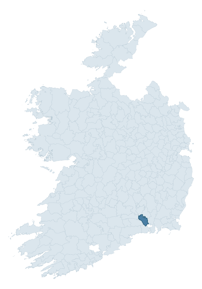
Where this barony sits in the Republic of Ireland
Geology and preservation
Bedrock geology shapes the landscape long before any settlement begins — controlling soil drainage, agricultural potential, the survival of upstanding monuments, and the preservation of buried archaeology. The figures below come from the Geological Survey Ireland 1:100,000 bedrock map.
The bedrock underlying Iverk is predominantly limestone (59% of the barony by area), laid down during the Carboniferous period (62% by area, around 359 to 299 million years ago). Limestone is the most heritage-rich bedrock in Ireland. It supports fertile, well-drained soils that favoured dense Early Medieval settlement and Norman manorial agriculture, and it weathers into karst features — sinkholes, caves, swallow holes, and souterrains — that frequently carry archaeology. Where peat overlies limestone, organic preservation can be exceptional. A substantial secondary geology of sandstone (34%) adds further variety to the underlying landscape.
Rock type composition
Largest mapped unit: Ballysteen Formation (22% of the barony)
Placename evidence
Logainm records 24 heritage-diagnostic placenames for Iverk, drawn from townland and civil-parish names across the barony. The dominant stratum is Early Christian ecclesiastical — cill-, teampall-, and domhnach-prefixed names that record the dense network of early church foundations established between the fifth and tenth centuries. The leading diagnostic roots are cill- (8 — church), ráth- (4 — earthen ringfort), and teampall- (3 — church). This is broadly in line with the ROI average of 30.7 heritage placenames per barony. The presence of multiple heritage strata side by side indicates layered occupation of the landscape across successive prehistoric and historic periods. Logainm records 119 placenames for Iverk (predominantly townland names). Of these, 24 (20%) carry one of the diagnostic Gaelic roots tracked above; the remainder draw on more generic landscape vocabulary that does not encode a heritage period.
Pre-Christian / Early Medieval Defensive
| Root | Count | Meaning |
|---|---|---|
| ráth- | 4 | earthen ringfort |
| dún- | 2 | hilltop or promontory fort |
| lios- | 1 | ringfort or enclosure |
| caiseal- | 1 | stone ringfort |
Early Christian Ecclesiastical
| Root | Count | Meaning |
|---|---|---|
| cill- | 8 | church (early) |
| teampall- | 3 | church (later medieval) |
| tobar- | 2 | holy well |
| gráinseach- | 1 | monastic farm / grange |
Burial, Ritual, and Norse-Contact
| Root | Count | Meaning |
|---|---|---|
| leaba- | 1 | megalithic tomb |
Other baronies in Kilkenny
- Gowran
- Fassadinin
- Kilculliheen
- Crannagh
- Shillelogher
- Ida
- Callan
- Rathconrath — Westmeath
- Ballinacor North — Wicklow
- Ballaghkeen North — Wexford
See all 280 baronies in the Republic of Ireland Heritage Tool.

Explore further
Grounding History: 10 Maps of Northern Ireland’s Past
If you’re interested in Irish heritage more widely, the companion report for Northern Ireland brings together the analysis of all 462 NI wards into one place through 10 high-quality maps — covering monument density, archaeological periods, placename heritage, terrain, wetland, and the historic landscape at first survey. Take a look.
About this profile
Click any section below to expand.
What is a barony?
A barony is a historic administrative unit in Ireland, broadly equivalent to an English hundred. The 280 baronies used here are from the OSi 2019 National Statutory Boundaries (generalised 20m), covering the 26 counties of the Republic of Ireland. Baronies derive from the Norman period, were formalised in the 17th century, and have not been redrawn for statistical purposes. They vary enormously in area, from compact urban baronies in Dublin to vast upland baronies in Connacht, and should not be compared by raw site count without accounting for area differences.
What counts as a site?
This profile combines three distinct heritage registers, each with its own definition of what constitutes a recordable site:
- Archaeological sites (NMS). The National Monuments Service Sites and Monuments Record (SMR) catalogues every known archaeological monument or site of archaeological interest in the Republic, from prehistoric burial mounds and ringforts to medieval churches and post-medieval defensive works. Inclusion does not require legal protection — only that the site has been identified, surveyed, and assessed as having archaeological value. A separate subset of these sites lies within a recorded protection zone, which gives them statutory protection under the National Monuments Acts.
- Listed buildings (NIAH). The National Inventory of Architectural Heritage records buildings of architectural, historical, archaeological, artistic, cultural, scientific, social, or technical interest. Each surveyed structure is appraised on a five-tier scale: International, National, Regional, Local, and Record-Only. The NIAH appraisal is informational rather than strictly statutory, but it underpins local-authority Record of Protected Structures (RPS) listings.
- Heritage placenames (Logainm). Logainm is the authoritative database of Irish placenames maintained by the Placenames Branch. This profile applies a heritage-diagnostic classifier to the Irish-language form of each townland name, flagging roots that signal defensive sites (ráth-, lios-, dún-, caiseal-, cathair-), ecclesiastical foundations (cill-, teampall-, domhnach-, mainistir-), prehistoric burial-ritual features (tuaim-, carn-, leaba-), or Norse-contact settlement (gall-). Townlands without one of these diagnostic roots are not flagged here — they may still carry historical significance, but that significance is not encoded in the name itself.
Editorial principles
The narrative sections of this profile follow several explicit principles:
- Evidential. Every claim about this barony’s heritage character is anchored in the underlying register data. Where a site count, a placename count, or a percentile rank is cited, it is computed from the source datasets at export time, not estimated.
- Comparative. Counts and metrics are reported alongside their percentile rank against the other 279 ROI baronies. A barony with 50 ringforts in absolute terms could be unusually high or unusually low depending on its size and regional context; percentile ranking removes that ambiguity.
- Transparent on limits. Where a register has known coverage gaps, survey biases, or data-quality issues that affect this barony’s figures, the profile flags them rather than presenting the numbers as definitive.
- No interpretation beyond what the data supports. The narrative does not speculate about historical events, social dynamics, or cultural meaning beyond what the recorded heritage and placename evidence directly attests.
Data caveats and limits
- NMS Sites and Monuments Record is the product of survey campaigns conducted at different intensities across different counties and decades. Some baronies have been surveyed more thoroughly than others, and absolute counts should be read in that light. Sites destroyed by development before survey are typically not represented; sites in heavily forested or upland terrain are sometimes under-recorded.
- NIAH coverage is broadly complete for the Republic of Ireland but the survey was conducted on a rolling county-by-county basis, and the most recent appraisal date varies. Buildings demolished or substantially altered after their original survey may still appear in the register; conversely, recent buildings of merit may not yet have been appraised.
- Logainm classification applies a deliberately conservative pattern-matching approach to the Irish-language townland forms. The classifier prioritises true positives over recall: a townland may carry a heritage signal that the classifier doesn’t recognise, particularly where the diagnostic root has been heavily anglicised or where the townland name draws on a less common term. The 60,000+ townland records and ~9,800 classified placenames give a substantial signal at barony scale, but individual townland names should be checked against Logainm directly for definitive interpretation.
- Period attribution. The chronological distribution reflects only those NMS sites that carry a recognised period attribution in the source data. Sites listed as “Unknown” period are excluded from the dated subset.
- Boundary changes. Some baronies have undergone minor boundary adjustments since their 19th-century definition; the OSi 2019 generalised boundaries used here are the current statutory definition and may differ slightly from historical maps in border areas.
- Bedrock geology is mapped at 1:100,000 scale, which means local variation within a barony — small pockets of different rock type, mineral veins, alluvium overlying bedrock — is generalised. The dominant-system and rocktype figures are area-weighted, so a barony reading “70% Carboniferous limestone” may still contain small but archaeologically important pockets of older or younger rock. Around 3% of GSI polygons do not match the lexicon and contribute no rocktype or system attribution.
Data sources
- National Monuments Service — Sites and Monuments Record (SMR) https://data.gov.ie/dataset/national-monuments-service-archaeological-survey-of-ireland
- National Inventory of Architectural Heritage (NIAH) https://data.gov.ie/dataset/national-inventory-of-architectural-heritage-niah-national-dataset
- Logainm — Placenames Database of Ireland https://www.logainm.ie/
- Ordnance Survey Ireland — National Statutory Barony Boundaries 2019 https://data-osi.opendata.arcgis.com/
- EURODEM — European Digital Elevation Model https://www.mapsforeurope.org/datasets/euro-dem
- ESA WorldCover https://esa-worldcover.org/en
- Geological Survey Ireland — 1:100,000 Bedrock Geology https://www.gsi.ie/en-ie/data-and-maps/Pages/Bedrock.aspx
Explore more: Search any of the 280 ROI baronies, browse by historical province, or read the methodology and data sources for the full Republic of Ireland Heritage Tool.