
Slane Upper is a barony of County Meath, in the historical province of Leinster (Irish: Baile Shláine Uachtarach), covering 118 km² of land. The barony records 385 NMS archaeological sites and 67 NIAH listed buildings, placing it at around the 85th percentile among 280 ROI baronies for sites per km². This means it is in the top fifth of all baronies for sites per km². Dated archaeological evidence runs from the Neolithic through to the Modern, spanning 7 of 9 archaeological periods, placing the barony in the 29th percentile among 280 ROI baronies for chronological depth. This means it is in the bottom third of all baronies for chronological depth. The largest dated subset of recorded sites dates to the Neolithic.
Heritage at a glance
Percentile rankings throughout this profile compare each barony only against the other 279 Republic of Ireland baronies.
The recorded heritage of Slane Upper
The National Monuments Service Sites and Monuments Record (SMR) is the statutory inventory of archaeological sites for the Republic of Ireland, maintained by the Department of Tourism, Culture, Arts, Gaeltacht, Sport and Media. Sites recorded here include earthworks, ringforts, megalithic tombs, ecclesiastical remains, and post-medieval features; not every record is legally protected, but each is registered as a monument of archaeological interest.
The National Monuments Service records 385 archaeological sites in Slane Upper, putting it at the 85th percentile among 280 ROI baronies for sites per km². This means it is in the top fifth of all baronies for sites per km². Protection coverage is near-universal — 379 sites (98%) fall within a recorded monument protection zone, indicating an extensively surveyed landscape. The record is dominated by defensive sites — ringforts, enclosures, hillforts, and stone forts (94 sites, 24% of the total), with burial and ritual monuments forming a substantial secondary presence (41 sites, 11%). The most diagnostically specific type is Ringfort – rath (24 records, 6% of the barony's NMS total) — compared to an ROI average of 20% across all baronies where this type occurs. Ringfort – rath is an earthen ringfort enclosed by a bank and external ditch — the most common Early Medieval farmstead, broadly dated 500–1000 AD. The broader 'Enclosure' classification — which catches unclassified ringforts and field enclosures — accounts for a further 36 records (9%) and reflects the difficulty of sub-classifying degraded earthworks from surface evidence alone. Across the barony's 118 km², this gives a recorded density of 3.26 sites per km².
Most common monument types
Hover or tap a monument type to see its definition.
| Type | Count |
|---|---|
| Enclosure a banked or ditched feature of uncertain type, used as a catch-all where the original function cannot be determined from surface evidence | 36 |
| Ringfort – rath an earthen ringfort enclosed by a bank and external ditch — the most common Early Medieval farmstead, broadly dated 500–1000 AD | 24 |
| Souterrain an underground stone-built passage and chamber, generally Early Medieval and often associated with ringforts as a defensive or storage feature | 17 |
| Ring-ditch a circular ditch under 20m across, often the ploughed-out remains of a barrow, ring-barrow or roundhouse | 15 |
Chronological distribution
The dated archaeological record for Slane Upper spans from the Neolithic through to the Modern, with activity attested across 7 of 9 archaeological periods. The record is near-continuous, with only the Post Medieval period falling inside the span without any recorded sites. Activity concentrates most heavily in the Neolithic (91 sites, 30% of dated material), with the Iron Age forming a secondary peak (81 sites, 27%). A further 85 recorded sites (22% of the overall NMS register for the barony) carry no period attribution — appearing as 'Unknown' in the bar chart below. This typically reflects either records that pre-date the standardised period vocabulary or sites awaiting specialist dating review, rather than a genuine absence of chronological evidence.
Sample of recorded monuments
Show 25 sample monuments (of 385 total)
A representative sample of 25 recorded monuments drawn from the barony’s 385 total NMS entries. Sites within a recorded monument protection zone and rarer site types are prioritised so the list shows a meaningful cross-section rather than only the most common type. Each entry shows the official Sites and Monuments Record reference number and the description published by the National Monuments Service.
Megalithic tomb – portal tomb
Located on a NW-facing slope. This monument was first published by Conwell (1864-6) who highlighted the cupmarks on the upper surface of the roofstone, although it was always admitted that these might be the result of…
Located on a NW-facing slope. This monument was first published by Conwell (1864-6) who highlighted the cupmarks on the upper surface of the roofstone, although it was always admitted that these might be the result of weathering as is probably the case. Of the incised art on the underside of the roofstone and the side of the only upright facing inwards there could be no doubt, although it was difficult to provide a context. The tomb and its art was much discussed in the early days (du Noyer 1868; Borlase vol. 2, 343-4; Atkins 1896, Lecture Waterford Archaeological Journal, 2, 72-4; Tempest 1939), and Raftery (1939) was of the view that two of these curvilinear designs including a triskele motif were Iron Age in date, and he is probably right. The other designs, largely simple circles, have affinities in Passage Tomb art from the Boyne valley (Shee-Twohig, 1981, 236; 2004, 226).
The remains of the tomb consist of a large roofstone (3.25m x 2.3m; T 0.85m) resting against a single upright stone (H 1.45m), possibly the sole surviving orthostat of a portal-tomb. An inclined slab beside it to the S appears to be set in the ground and may represent a further structural element, possibly a sillstone.
Revised by: Michael Moore
Date of upload: 18 April 2017
Amended: 3 August 2022
Hillfort
Occupying the SW end of a NE-SW ridge (L c. 1.2km) that has three summits, the ground falls away steeply on all sides except N-NE where the slope is much less before the ground rises again to the central summit. This…
Occupying the SW end of a NE-SW ridge (L c. 1.2km) that has three summits, the ground falls away steeply on all sides except N-NE where the slope is much less before the ground rises again to the central summit. This almost perfectly circular hilltop enclosure is represented as field banks with no annotation on the 1836 and 1908 editions of the OS 6-inch map, although the hilltop barrow is described as a ‘Moat’. The enclosure is a circular grass-covered area (diam. 164.5m E-W; 163m N-S) defined by an earthen bank that had been adapted as a field bank with a stone-facing and outer drain, especially N-SE. In an untouched form the bank can vary (Wth of base 4-5m; int. H 0.2-.5m; ext. H c. 2-2.5m) and the outer fosse can vary from very slight (Wth c. 3m; ext. D 0.5m) to more substantial and rock-cut (ext. D c. 1.5m). An original entrance is not identified. (Ó Riordáin (1956)
This monument is subject to a preservation order made under the National Monuments Acts 1930 to 2014 (PO no. 12/1987), and is in state ownership: No. 651.
The above description is derived from the published 'Archaeological Inventory of County Meath' (Dublin: Stationery Office, 1987). In certain instances the entries have been revised and updated in the light of recent research.
Compiled by: Michael Moore
Date of upload: 10 July 2007
Amended: 3 August 2022
Castle – motte
Situated on the summit of the Hill of Slane, which is one of the highest hills in lowland Meath, affording wide views over the surrounding countryside where, when not obscured by trees, the hills of Skreen, Tara, the…
Situated on the summit of the Hill of Slane, which is one of the highest hills in lowland Meath, affording wide views over the surrounding countryside where, when not obscured by trees, the hills of Skreen, Tara, the Hill of Lloyd, Slieve na Caillaighe, Slieve Breagh and Mount Fortescue can be identified on the horizon. The hill would have been important in prehistory, and the Síl nÁedo Sláine dynasty of the Uí Néill originated in Slane, which is probably why Saint Patrick came here, to Ferta Ferr Féicc – the burial ditches of Fécc, to light the first defiant Pascal fire. During the high Middle Ages Slane became the caput or centre for the barony of Slane which was granted to Richard le Fleming in 1172 by Hugh de Lacy, and a castle – Dumhach Sláine – the mound or barrow of Slane – had been built by 1176 when it was burned by Mael Seachlainn Ó Lochlainn. A hundred men were killed on this occasion with women and children in addition. This was undoubtedly an earthen motte castle, although it may have been built over an important prehistoric barrow. In its present form this monument is a motte, although it has some features of a Ceremonial enclosure such as the association of a mound and a large earthwork enclosure (Herity 1993, 145-6). However, the large enclosure could also be the result of post-medieval landscaping. (Bradley and King 1985, 140-1)
This is a flat-topped, grass and tree-covered mound of earth (diam. of base 45m; diam. of top 19-21m; H 6.5m at SE to 7.8m at…
Ecclesiastical residence
Located on the E-facing slope of the Hill of Slane and c. 20m N of the church (ME019-060002-). In 1512 Sir Christopher Fleming and his wife, Elizabeth Stuckly, established a College of canons at Slane. It was endowed…
Located on the E-facing slope of the Hill of Slane and c. 20m N of the church (ME019-060002-). In 1512 Sir Christopher Fleming and his wife, Elizabeth Stuckly, established a College of canons at Slane. It was endowed with 100 acres and the rent of 20 houses for four priests, four clerks and four choristers (Westropp 1901, 409-10; Cogan 1862, 1, 284-6). Cogan suggests (ibid. 284-5) that the priests were the Franciscans from St Erc’s Hermitage (ME019-026—-). The building was designed as a small cloister, with an existing tower house (ME019-060010-) at its SE angle. At the Suppression in 1540 it seems to have become the property of the parish. The buildings have probably been derelict since then, and they were certainly defunct by the early seventeenth century when in 1622 Usher described the walls as still standing and attached to the parsonage (ibid. 286), by which is probably meant the tower house.
The college was tacked onto the tower house, which is at the SE angle of the complex, and it was probably constructed in two phases, the E and N ranges being first. The E range (int. dims 15.25m N-S; 6.5m E-W) was largely rebuilt when it was conserved in the twentieth century but it has a passage (Wth 1.95m), now reduced to the basal courses, through it towards its N end, which created rooms to the N (Wth 4.03m N-S) and S (Wth 7.1m N-S) but also accessing the cloister (dims 13m E-W; 10.65m N-S) directly. The gatehouse (ME019-060009-) is aligned with this passage but c. 7m…
Barrow – ditch barrow
Situated in the SW part of the interior of the henge (ME019-016001-) and just NE of the hut site (ME019-016002-). Archaeological excavation (E000090) recorded a circular area (int. diam. 4.5m) defined by a continuous…
Situated in the SW part of the interior of the henge (ME019-016001-) and just NE of the hut site (ME019-016002-). Archaeological excavation (E000090) recorded a circular area (int. diam. 4.5m) defined by a continuous ditch (Wth of top 1-1.1m; Wth of base 0.5-0.6m; max. D 1m), the base of which was lined with cobbles. The cobbles had been removed at NE where there was a hearth, and a sherd of Beaker pottery was found at the base of the ditch. At the centre of the enclosed area a pit (diam. 0.5m; D 0.3m) had a fragile flat-based pot resting on a slab and one sherd of another finer ware but human remains did not survive. (Sweetman 1971, 139-40; 1976, 35-37)
Compiled by: Michael Moore
The above description is derived from the published 'Archaeological Inventory of County Meath' (Dublin: Stationery Office, 1987). In certain instances the entries have been revised and updated in the light of recent research.
Date of upload: 10 July 2007
Amended: 28 January 2021
Flat cemetery
Located on a slight E-facing slope and inside the bank of the henge (ME019-016001-) NW-NE. Archaeological excavation (E000090) in 1970 recorded 12 cremated burials, 9 in pits often with rounded stones closing the pit,…
Located on a slight E-facing slope and inside the bank of the henge (ME019-016001-) NW-NE. Archaeological excavation (E000090) in 1970 recorded 12 cremated burials, 9 in pits often with rounded stones closing the pit, and 2 in cists while one was on the old ground surface. Some of the pits had no contents, although all were covered with a red clay that appeared to have been introduced.
Pit 1 (dims 1m x 0.8m; D 0.45m) had no bones or artefacts but was covered by a large stone (dims 1.05m x 0.4m) which may have been a grave-marker. Pit 2 was a shallow depression with a Carrowkeel ware bowl and the cremated remains of a child. Pit 3 (dims 1.75m x 1.25m; D 0.5m) was covered by small overlapping stones but had no bones or artefacts. Pit 4 was rectangular (dims 1.1m x 0.9m; D 0.5m) and had some cremated bone near the top but produced no artefacts. Pit 5 was a polygonal cist (dims c. 0.45m x c. 0.4m; D c. 0.6m) consisting of 6 upright slabs splaying outwards slightly as they rose but there was no covering stone, which may have been removed in recent land works. A small amount of cremated bone was on the flag floor. Pit 6 was a polygonal cist (dims c.0.95m E-W; c. 0.7m N-S; D 0.45m) with 8 upright slabs and some collapsed drystone walling covered by a single capstone (1.4m x 0.9m; T 0.25m). It had a flagstone at the W edge of the base on which was a cremation, while just to the W and slightly higher in the fill was the partially burned skull and part of the pelvis of an adult…
Cross – Wayside cross
Situated on a rise with rock outcrop on the S-facing slope of Carrickdexter Hill, and on the S side of the old road from Slane to Navan. This cross of fossiliferous limestone is known as the Baronstown cross (Wilde…
Situated on a rise with rock outcrop on the S-facing slope of Carrickdexter Hill, and on the S side of the old road from Slane to Navan. This cross of fossiliferous limestone is known as the Baronstown cross (Wilde 1849, 170) and was erected c. 1607 by Jennet Dowdall and her husband Oliver Plunket. It is complete, with a shaft (dims 0.36m x 0.23m; H 2.22m) and collar (dims 0.57m x 0.4m; H 0.2m) but the upper shaft is modern. It has inscriptions, figure sculpture and heraldic shields on all four sides. It is described by King (1984, 106) as:
This cross consist of a lower shaft, collar and upper shaft. Both the lower shaft and collar are rectangular in section, decorated in relief and false relief. It is now set on a modern plinth and is badly weathered. The shaft is decorated with inscriptions, figure sculpture and heraldic shields. The inscriptions are in very badly executed Roman lettering and are full of contractions.
W side: S/AINT PETR/. Underneath the inscription the saint is shown with two keys, wearing a mitre and pleated tunic in an ogee-headed panel. The inscription continues: (I) PRAY YO(U)/ SAINT PETE/R PRAY FO/R THE SOV(L)ES OF OLIV/ER PLUNKET/ (LO)RD BARON/(OF) LOUTH & DAME JENET/DOWDALL/HIS WIFE/.
E side: SA/INT PATRI/ACK. Below, a bearded St Patrick is holding a double crossed crozier in his left hand and giving a blessing with his right, in an off-centre ogee-headed panel. The remainder of the inscription is: I PRAY YOU/SAINT PA(T)RICK PRAY/FOR THE SO…
Bridge
Crossing a NW-SE section of the River Boyne with the steep sides of the valley rising immediately on the NE side and c. 80m from the river bank on the SW side. Edward Bruce’s army crossed the river at Slane in 1317, but…
Crossing a NW-SE section of the River Boyne with the steep sides of the valley rising immediately on the NE side and c. 80m from the river bank on the SW side. Edward Bruce’s army crossed the river at Slane in 1317, but it is not known if a bridge facilitated this. If there was a bridge, it did not survive the flood of 1330. There is a reference to a bridge at Slane in 1599, and the bridge is depicted on the Down Survey (1656) barony and parish maps of Slane. It seems to have been provided with a gate as the Civil Survey (1654) describes ‘a Stone Bridge with an ould castle thereon’ (Simington 1940, 343). The bridge at Slane is marked on Moll’s map of 1714 and on Taylor and Skinner’s 1778 map of the roads of Ireland (Andrews 1969, 41). (O’Keefe and Simington 1991, 153-6; 2016, 172-80)
The bridge with the causeway on the SW side (total L c. 160m) has 13 arches. On the SE or down-river side seven of these have pointed or segmental arches that are probably in their original form. Five of these are in the river and the others are for overflow on the banks. The bridge was expanded in width as can be seen in the join under the arches. The SE side (Wth 4.8m) is original and the NW side (Wth 2.5m) was added and the piers provided with breakwaters, probably in the early nineteenth century.
The above description is derived from the published 'Archaeological Inventory of County Meath' (Dublin: Stationery Office, 1987). In certain instances the entries have been revised and update…
Religious house – Franciscan Third Order Regular
Located in deciduous woodland and situated in a fold towards the bottom of the steep S-facing slope of Slane Hill, with a NW-SE section of the River Boyne c. 50m to the SW. Sometime before 1512 Christopher Fleming, lord…
Located in deciduous woodland and situated in a fold towards the bottom of the steep S-facing slope of Slane Hill, with a NW-SE section of the River Boyne c. 50m to the SW. Sometime before 1512 Christopher Fleming, lord of Slane, and his wife, Elizabeth Stuckly, granted St. Erc’s hermitage to Fr. Malachy O’Bryen and Br. Donagh O’Bryen of the Franciscan Third Order, who were already living there (Gwynn and Hadcock 1970, 274-5). This suggests that there was an older structure at this location. At the Suppression in 1540 it was described as a church and chancel with a belfry, a cottage and 1 acre of land (White 1943, 313), but it had no other possessions.
The church is almost complete, apart from much of the S nave wall, and consists of a nave (int. dims c. 10.8m E-W; c. 4.65m N-S at E to c. 5.33m N-S at W) and chancel (int. dims c. 8.8m E-W; c. 4.42m N-S) separated by a tower, with a two-storey dwelling (int. dims c. 4.06m E-W; c. 3.5m N-S) attached to the S of the tower. The dwelling appears to be the earliest structure onto which the tower was added, with the nave and chancel built subsequently (Channing 1995, 12). The only feature on the N wall of the nave is a possible window embrasure towards the E end, and the N walls are cut into the hill-slope or retaining slip. All the small lights are round-headed.
Because of the hillslope, the floor levels in the dwelling are lower than the corresponding floors of the tower. The ground floor of the dwelling has a blocked win…
Burial ground
Located in a slight E-W dip or fold between a rise to the N and the ridge of Knowth c. 200m to the S, and it is also at the headwaters of a small WSW-ENE stream. This monument is designated Site M (O’Kelly 1978, 61) and…
Located in a slight E-W dip or fold between a rise to the N and the ridge of Knowth c. 200m to the S, and it is also at the headwaters of a small WSW-ENE stream. This monument is designated Site M (O’Kelly 1978, 61) and comprises a circular grass-covered area (diam. 80m) defined by an earthen bank with a lot of stone (at W: Wth of base 6m; H 0.8m) separated by a fosse (at W: Wth of top 5m; max. D 0.9m) from an external bank (at W: Wth of base 5.5m; H 0.65m) (max. ext. diam. 105m). There are a number of gaps in the banks, the largest (Wth 11m) being at SSW with another (Wth 6.5m) at SSE, but none appears to be original. Within the inner bank is an eccentrically placed enclosure (diam. 67m) defined by a silted ditch (Wth c. 2-3m) surrounding its domed interior. The field system (ME019-027—-) appears to be contemporary and field boundaries are attached to the large enclosure.
Seasonal archaeological excavation (02E0726) between 2002 and 2004 revealed that there is a burial ground enclosed by two sub-circular ditches of 6th-10th century AD date at the centre but the relationship with the two visible outer banks is not absolutely established (Stout G & M 2008). The inner enclosure (dims 48m NW-SE; 40m NE-SW) is defined by a ditch, varying in form from V-shaped (Wth 2.45; D 0.9m) to flat-bottomed (Wth 1.95m; D 0.65m) with slight evidence of an internal bank in a sterile yellow clay (Wth 1.8m; H c. 0.2m). A blue glass bead and an Anglo-Saxon mount were in the topsoil over the…
Pit circle
Circular area defined by circle of large pits within which were concentric lines of burials revealed in excavation by P.D. Sweetman. C14 dates centred c. 2000 BC. (Sweetman 1985, 195-221).
The above description is…
Circular area defined by circle of large pits within which were concentric lines of burials revealed in excavation by P.D. Sweetman. C14 dates centred c. 2000 BC. (Sweetman 1985, 195-221).
The above description is derived from the published 'Archaeological Inventory of County Meath' (Dublin: Stationery Office, 1987). In certain instances the entries have been revised and updated in the light of recent research.
Date of upload/revision: 10 July 2007
Mill – corn
Browe Mill located on the River Boyne is listed in the possessions of the Cistercian abbey of Mellifont at its dissolution in 1539 (Stout 2002, 89). The Civil Survey of 1654 recorded two mills in the townland of…
Browe Mill located on the River Boyne is listed in the possessions of the Cistercian abbey of Mellifont at its dissolution in 1539 (Stout 2002, 89). The Civil Survey of 1654 recorded two mills in the townland of Newgrange (ibid., 111-12). One of these mills was probably Browe Mill. A corn mill is depicted at this location on Bernard Scalé's map of the Caldwell estate dating from 1766 (ibid., 130-1; 133). This mill may have been one of the mills listed in the Civil Survey of 1654. No mill is depicted at this location on any edition of the OS 6-inch maps. However a rectangular structure depicted on the 25-inch map at this location may be the remains of the mill shown on the 1776 map.
Compiled by: Caimin O'Brien
Date of upload: 13 November 2013.
Megalithic tomb – unclassified
Situated on a gentle S-facing slope in the vicinity of the great passage tomb of Dowth (ME020-017—-) and the medieval parish church (ME020-019—-). Lewis (1837, vol. 1, 496) describes a cromlech ‘consisting of four…
Situated on a gentle S-facing slope in the vicinity of the great passage tomb of Dowth (ME020-017—-) and the medieval parish church (ME020-019—-). Lewis (1837, vol. 1, 496) describes a cromlech ‘consisting of four large upright stones, and several others lying near’. Sir William Wilde (1849, 210-11) mentions a giant’s tomb in the vicinity of the great tomb and Dowth castle (ME020-018—-) in addition to the Cloghalea stones (ME020-009—-) with which it might be confused. O’Kelly (1978, 59-60) observed a number of large stones against the E boundary of this field, and there is a quarry at one point which might be the site of this structure and account for the removal of the tomb.
The above description is derived from the published 'Archaeological Inventory of County Meath' (Dublin: Stationery Office, 1987). In certain instances the entries have been revised and updated in the light of recent research.
Compiled by: Michael Moore
Date of revision: 10 September 2018
Passage tomb art (present location)
This monument is depicted as a black dot on the revised 1908 edition of the OS 6-inch map where it is shown located on the S side of a field boundary running ENE-WSW. According to O'Kelly this stone was originally…
This monument is depicted as a black dot on the revised 1908 edition of the OS 6-inch map where it is shown located on the S side of a field boundary running ENE-WSW. According to O'Kelly this stone was originally located 'on the headland at the edge of the field, but was pushed into the drain to get it out of the way. Immediately on the other side of the fence are three ancient mounds (ME019-040—-; ME019-041—-); ME019-042—-)' (O'Kelly 1967, 45). This large stone (H 1.98m; Wth 1.22m; max. T 1.06m) has a broad heavy base and is flat on one face and bulbous on the other side. The top right hand corner of the flat face is decorated with 'a well-made single spiral of five revolutions, the outermost curve having a free end. To the left and below the spiral are two roughly-made devices. One of them appears to be an attempt at a simple maze pattern, the other perhaps the same or a pair of concentric circles. Below them is a serpent-like device, rather difficult to see. the serpent's head is a shallow, circular cup-mark. Slightly to the left and just below the first curve of the serpent is another shallow cup mark. Just below the latter and a little to the right of it is another simple maze pattern. Towards the bottom right, there is a single shallow cup-mark. On the back of the stone and low down is a well-made spiral of eight revolutions. Its external free end has disappeared because a small lamina has flaked off the surface. A small "satellite" circle is attached…
Stone head
A female stone head is set into the N pier of the entrance to the graveyard (ME019-060016-), and two architectural fragments (ME019-060003-) are set in the graveyard wall nearby. The head (Wth 0.2m; H 0.36m; D 0.26m)…
A female stone head is set into the N pier of the entrance to the graveyard (ME019-060016-), and two architectural fragments (ME019-060003-) are set in the graveyard wall nearby. The head (Wth 0.2m; H 0.36m; D 0.26m) has bulging eyes, a pillbox hat decorated with foliage at the front but at thes sides are animals. (Westropp 1901, 420; Bradley and King 1985, 146)
Compiled by: Michael Moore
Date of upload: 11 June, 2014
Shrine
In the graveyard on Slane Hill (ME019-060016-) there is a slab-shrine S of the church tower, which consists of two gable-shaped stones (W stone: dims 0.95m N-S; 0.25m E-W; H 1.4m; E stone: 1.12m N-S; 0.23m E-W; H…
In the graveyard on Slane Hill (ME019-060016-) there is a slab-shrine S of the church tower, which consists of two gable-shaped stones (W stone: dims 0.95m N-S; 0.25m E-W; H 1.4m; E stone: 1.12m N-S; 0.23m E-W; H 1.57m) placed 1.2m apart, but the side-stones are missing. There is a third pointed stone (dims 0.4m N-S; 0.16m E-W; H 0.44m) 0.9m to the E that may be part of it. (Westropp 1901, 418; Bradley and King 1985, 146; Seaver and Brady 2011)
Compiled by: Michael Moore
Date of upload: 16 June, 2014
Gatehouse
Located on the E-facing slope of the Hill of Slane, and c. 7m E of the College (ME019-060008-). This is a masonry structure (dims 3.8m N-S; 3.05m E-W) with an entrance passage (int. Wth 1.9m) through it. There are two…
Located on the E-facing slope of the Hill of Slane, and c. 7m E of the College (ME019-060008-). This is a masonry structure (dims 3.8m N-S; 3.05m E-W) with an entrance passage (int. Wth 1.9m) through it. There are two draw-bar sockets on each pier inside the outer end of the passage, and there are the remnants of a newel stairs in the S pier. Externally, there is a coped plinth (H 1.5m) on the E face of each pier, and a string course above as well as the springing of an arch. The passage of the gatehouse is aligned with the passage through the E range of the College, allowing direct access to the cloister, although it might have been built with the tower house (ME019-060007-) as an entrance to a small bawn.
The above description is derived from the published 'Archaeological Inventory of County Meath' (Dublin: Stationery Office, 1987). In certain instances the entries have been revised and updated in the light of recent research.
Compiled by: Michael Moore
Date of upload: 10 July 2007
Amended: 28 January 2021
Architectural feature
The segmental arched doorway (Wth 0.95m; H 2.05m) from the W end of the S wall of Stackallan parish church (ME018-030—-) with its hood moulding that terminates in foliage half way down the jambs is now built into the…
The segmental arched doorway (Wth 0.95m; H 2.05m) from the W end of the S wall of Stackallan parish church (ME018-030—-) with its hood moulding that terminates in foliage half way down the jambs is now built into the W wall of the vestry at St Patrick's Church of Ireland church in Slane. The escutcheon from over the doorway was also re-installed at Slane (ME019-023004-).
Compiled by: Michael Moore
Date of upload; 16 June, 2014
Armorial plaque (present location)
Two medieval graveslabs and other features from the parish church of Stackallan (ME018-030—-) are now attached to the W wall of the vestry of the Church of Ireland church at Slane (ME019-023004-). The escutcheon from…
Two medieval graveslabs and other features from the parish church of Stackallan (ME018-030—-) are now attached to the W wall of the vestry of the Church of Ireland church at Slane (ME019-023004-). The escutcheon from over the doorway is the arms of Barnewall, and the inscription is to Sir Barnaby Barnewall, who died in 1493, and his wife, Margaret Plunkett. According to du Noyer (1891) the inscription reads: ‘Scutum Barnabe Barnewelle / Militis Secundam judiciari / de banco Capitale regis. / Margareta Plunket fuit uxor’ (Leask 1960, 2, 31-2; Bradley and King 1985, 151)
Compiled by: Michael Moore
Date of upload; 2 October, 2014
Stone sculpture (present location)
From Bradley and King (1985, 142-3): The ‘Apostle Stone’. Late 14th / early 15th century. A large coffin-shaped block of sandstone is a short distance west of St. Erc’s Hermitage (ME019-026—-). It is carved in relief…
From Bradley and King (1985, 142-3): The ‘Apostle Stone’. Late 14th / early 15th century. A large coffin-shaped block of sandstone is a short distance west of St. Erc’s Hermitage (ME019-026—-). It is carved in relief with six apostles on each of the long sides and a Crucifixion with Mary and John on the broader end. Many of the apostles are damaged so not all can be identified. They are dressed similarly in a tunic and cloak caught over the left arm. Only SS Paul and James are clearly identifiable. Hickey (1975) has shown that this is part of a composite tomb removed from St. Mary’s abbey in Navan (ME025-024—-) in the late 18th century. Its covering slab (ME019-021—-) is now at Slane Castle. Dims L 1.75m; Wth 0.42-0.52; H 0.44m
Date of upload: 15 July, 2014
House – medieval
Located in deciduous woodland and situated in a fold towards the bottom of the steep S-facing slope of Slane Hill, with a NW-SE section of the River Boyne c. 50m to the SW. Sometime before 1512 Christopher Fleming, lord…
Located in deciduous woodland and situated in a fold towards the bottom of the steep S-facing slope of Slane Hill, with a NW-SE section of the River Boyne c. 50m to the SW. Sometime before 1512 Christopher Fleming, lord of Slane, and his wife, Elizabeth Stuckly, granted St. Erc’s hermitage to Fr. Malachy O’Bryen and Br. Donagh O’Bryen of the Franciscan Third Order, who were already living there (Gwynn and Hadcock 1970, 274-5). This suggests that there was an older structure at this location, which may be this dwelling attached to the S of the church (ME019-026—-). At the Suppression in 1540 it was described as a church and chancel with a belfry, a cottage and 1 acre of land (White 1943, 313), but it had no other possessions.
The church (ME019-026—-) is almost complete, apart from much of the S nave wall, and consists of a nave and chancel separated by a tower, with a two-storey dwelling (int. dims c. 4.06m E-W; c. 3.5m N-S) attached to the S of the tower. The dwelling appears to be the earliest structure, onto which the tower was added, with the nave and chancel built subsequently (Channing 1995, 12). Because of the hillslope, the floor levels in the dwelling are lower than the corresponding floors of the tower. The ground floor of the dwelling has a blocked window in the W wall with a doorway at its N end, which may be an insertion (ibid. 11, 14). There is a fireplace and a blocked window in the S wall and a blocked window in the E wall. Its first floor, access…
Tomb – chest tomb
From Bradley and King (1985, 143), but it is also described by Du Noyer (1891) and Westropp (1901, 428): Chest tomb. This tomb is located against the N wall of the chancel of St. Erc’s Hermitage (ME019-026—-). Ellenor…
From Bradley and King (1985, 143), but it is also described by Du Noyer (1891) and Westropp (1901, 428): Chest tomb. This tomb is located against the N wall of the chancel of St. Erc’s Hermitage (ME019-026—-). Ellenor Fleming and Penelope Moore. 1667. A table tomb in the chancel is now dismantled except for one table support and the end panel which are in position against the N wall. The mensa consists of a large rectangular slab of limestone, three edges of which have concave and convex mouldings but the fourth side was intended to rest against a wall. The top has an achievement of arms in false relief of the Flemings, Moores, and Barnwalls. The supporters are two goats with collars and rings and the motto: BEARNE REGVN. Incised roman inscription:
THIS MONIMENT WAS ERECTED / BY RANDALL LORD BARON OF / SLANE MARIED FIRST TO ELLENOR / BARNEWALL WHO HERE IS / ENTERED DAVGHTER TO Sr RICHARD / BARNWALL OF CHRICKESTOWNE / KNIGHT & BARONETT & AFTER / TO THE LADY PENELOPE MOORE / DAVGHTER TO HENERY MOORE / EARLE OF DROGHEDA / ANNO 1667
The side panel is now completely covered by the mensa but it is a large rectangular piece of limestone. Trench (1976, 30-1, 45) describes it as having the arms of Moore impaled with Spencer and the following inscription: THIS IS THE COATE OF HENRY MOORE / EARLE OF DROGHEDA AND DAME ALICE / SPENCER HIS WIFE WHOSE DAVGHTER / PENELOPE MOORE IS SEACOND WIFE TO / RANDALL LORD BARRON OF SLANE / THE SAIDE DAME ALICE SPENCER DAVGHTER TO WILLIAM / LORD…
Barrow – stepped barrow
The Archaeological Survey of Ireland (ASI) is in the process of providing information on all monuments on The Historic Environment Viewer (HEV). Currently the information for this record has not been uploaded. To…
The Archaeological Survey of Ireland (ASI) is in the process of providing information on all monuments on The Historic Environment Viewer (HEV). Currently the information for this record has not been uploaded. To access available information for research purposes please make an appointment in advance with the Archive Unit (open Fridays 10.00 am – 5.00 pm), Department of Culture, Heritage and the Gaeltacht, The Custom House, Dublin 1 D01W6XO or email nmarchive@chg.gov.ie.
Cross (present location)
From King (1984, 103): A shaft fragment with a tenon at the base, decorated in false relief. Each face has figure sculpture and there are no inscriptions. 1st: Crucifixion. Christ is wearing a very stylised perizonium…
From King (1984, 103): A shaft fragment with a tenon at the base, decorated in false relief. Each face has figure sculpture and there are no inscriptions. 1st: Crucifixion. Christ is wearing a very stylised perizonium and there are two small figures at the foot of the cross which could either be Mary and John or the sponge and lance bearers. 2nd: Possibly a depiction of the Virgin and Child. She is wearing a pleated tunic and holds the child in her arms. He appears to be holding a circular object in his right hand. 3rd: A bearded ecclesiastic wearing a pleated alb and chasuble. 4th: St. Andrew wearing a pleated tunic and holding a large saltire cross.
This cross was not noticed by Westropp (1901, 405, 431) but was subsequently noted by FitzGerald (1913, 145) and Trench (1976, 31). A date early in the 16th century is suggested.‘
The cross was missing during the 1970s and 1980s, but was rediscovered at St. Erc’s Hermitage in 1985. It was presented by Lord Henry Mountcharles to an Taisce, who arranged to have it displayed at the Slane branch of the Meath County Library (Irish Times, 26/04/1985, 7).
Date of upload: 24 July, 2014
Enclosure
Located on the NE end of a short NE-SW ridge (L c. 200m) that is part of the ENE-WSW Slieve Breagh ridge. A large circular embanked enclosure (ext. diam. c. 70m N-S; c. 65m E-W) is depicted only on the 1836 edition of…
Located on the NE end of a short NE-SW ridge (L c. 200m) that is part of the ENE-WSW Slieve Breagh ridge. A large circular embanked enclosure (ext. diam. c. 70m N-S; c. 65m E-W) is depicted only on the 1836 edition of the OS 6-inch map where it is annotated as a ‘Fort’. In 1969 it was described (SMR file) as a circular area (diam. 50m N-S; 50m E-W) defined by a small section of a bank (Wth of base 4m; int. H 0.7m; ext. H 1.5m) incorporated into a field bank SE-S with an outer drain, and by a low scarp elsewhere.
The above description is derived from the published 'Archaeological Inventory of County Meath' (Dublin: Stationery Office, 1987). In certain instances the entries have been revised and updated in the light of recent research.
Compiled by: Michael Moore
Date of upload: 10 July 2007
Amended: 3 August 2022
Listed buildings
The National Inventory of Architectural Heritage (NIAH) is a state survey appraising buildings of architectural, historical, archaeological, artistic, cultural, scientific, social, or technical interest. Each surveyed structure receives a rating from International (the highest, for buildings of European importance) through National, Regional, Local, and Record-Only.
The NIAH records 67 listed buildings in Slane Upper (35th percentile across ROI baronies). All recorded buildings carry Regional or lower grading; the barony does not contain any structures appraised as being of National or International architectural importance. Construction dates concentrate most heavily in the Early Georgian (1700-1800) period. The most-recorded building type is house (18 examples, 27% of the listed stock).
Terrain and environment
Mean elevation across the barony is 92m — the 51st percentile among 280 ROI baronies for elevation. This means it is in the upper half of all baronies for elevation. Elevation matters for heritage because higher-altitude baronies typically favour defensive monuments — ringforts and hilltop forts placed on prominent ground — while lowland baronies are more likely to carry the dense settlement and church networks of intensive agricultural landscapes. A maximum elevation of 226m gives the barony meaningful vertical relief. Mean slope is 4.0° — the 57th percentile among 280 ROI baronies for slope. This means it is in the upper half of all baronies for slope. Slope is a key control on both land use and archaeological preservation: steep ground resists ploughing and tends to preserve earthworks intact, while gentle slopes favour intensive cultivation that damages or destroys surface archaeology over time. The Topographic Wetness Index averages 10.5, the 36th percentile among 280 ROI baronies for wetness. This means it is in the lower half of all baronies for wetness. Drainage matters for heritage because poorly-drained ground preserves organic archaeology (wooden trackways, leather, textiles, and on rare occasions human remains) far better than free-draining soil; well-drained ground favours arable use but destroys organic material rapidly. The land-cover mosaic combines improved grassland (74%), arable farmland (15%), and woodland (10%), giving a mixed agricultural and semi-natural landscape.
Terrain measurements
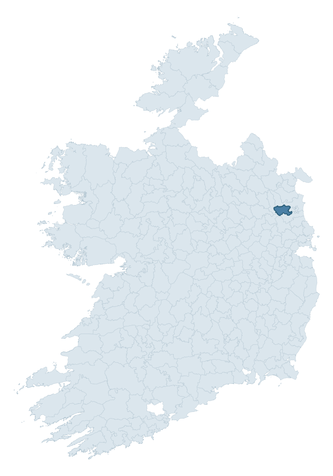
Where this barony sits in the Republic of Ireland
Geology and preservation
Bedrock geology shapes the landscape long before any settlement begins — controlling soil drainage, agricultural potential, the survival of upstanding monuments, and the preservation of buried archaeology. The figures below come from the Geological Survey Ireland 1:100,000 bedrock map.
The bedrock underlying Slane Upper is predominantly mudstone, siltstone, greywacke (40% of the barony by area), laid down during the Ordovician period (65% by area, around 485 to 444 million years ago). The single largest mapped unit is the Rathkenny Formation (40% of the barony's bedrock). With 15 distinct rock types mapped, the barony sits in the top third of ROI baronies for geological diversity (98th percentile) — typically a sign of complex tectonic history or coastal mosaics of differing rock units.
Rock type composition
Largest mapped unit: Rathkenny Formation (40% of the barony)
Placename evidence
Logainm records 9 heritage-diagnostic placenames for Slane Upper, a modest sample drawn predominantly from the townland record. The dominant stratum is pre-christian defensive. The most frequent diagnostic roots are ráth- (4) and gráinseach- (3). With a sample of this size the count should be treated as indicative rather than definitive.
Pre-Christian / Early Medieval Defensive
| Root | Count | Meaning |
|---|---|---|
| ráth- | 4 | earthen ringfort |
| dún- | 1 | hilltop or promontory fort |
| caiseal- | 1 | stone ringfort |
Early Christian Ecclesiastical
| Root | Count | Meaning |
|---|---|---|
| gráinseach- | 3 | monastic farm / grange |
Other baronies in Meath
- Skreen
- Navan Lower
- Fore
- Deece Upper
- Ratoath
- Kells Lower
- Moyfenrath Lower
- Cullenagh — Laois
- St. Mullin's Upper — Carlow
- Ballinacor North — Wicklow
See all 280 baronies in the Republic of Ireland Heritage Tool.

Explore further
Grounding History: 10 Maps of Northern Ireland’s Past
If you’re interested in Irish heritage more widely, the companion report for Northern Ireland brings together the analysis of all 462 NI wards into one place through 10 high-quality maps — covering monument density, archaeological periods, placename heritage, terrain, wetland, and the historic landscape at first survey. Take a look.
About this profile
Click any section below to expand.
What is a barony?
A barony is a historic administrative unit in Ireland, broadly equivalent to an English hundred. The 280 baronies used here are from the OSi 2019 National Statutory Boundaries (generalised 20m), covering the 26 counties of the Republic of Ireland. Baronies derive from the Norman period, were formalised in the 17th century, and have not been redrawn for statistical purposes. They vary enormously in area, from compact urban baronies in Dublin to vast upland baronies in Connacht, and should not be compared by raw site count without accounting for area differences.
What counts as a site?
This profile combines three distinct heritage registers, each with its own definition of what constitutes a recordable site:
- Archaeological sites (NMS). The National Monuments Service Sites and Monuments Record (SMR) catalogues every known archaeological monument or site of archaeological interest in the Republic, from prehistoric burial mounds and ringforts to medieval churches and post-medieval defensive works. Inclusion does not require legal protection — only that the site has been identified, surveyed, and assessed as having archaeological value. A separate subset of these sites lies within a recorded protection zone, which gives them statutory protection under the National Monuments Acts.
- Listed buildings (NIAH). The National Inventory of Architectural Heritage records buildings of architectural, historical, archaeological, artistic, cultural, scientific, social, or technical interest. Each surveyed structure is appraised on a five-tier scale: International, National, Regional, Local, and Record-Only. The NIAH appraisal is informational rather than strictly statutory, but it underpins local-authority Record of Protected Structures (RPS) listings.
- Heritage placenames (Logainm). Logainm is the authoritative database of Irish placenames maintained by the Placenames Branch. This profile applies a heritage-diagnostic classifier to the Irish-language form of each townland name, flagging roots that signal defensive sites (ráth-, lios-, dún-, caiseal-, cathair-), ecclesiastical foundations (cill-, teampall-, domhnach-, mainistir-), prehistoric burial-ritual features (tuaim-, carn-, leaba-), or Norse-contact settlement (gall-). Townlands without one of these diagnostic roots are not flagged here — they may still carry historical significance, but that significance is not encoded in the name itself.
Editorial principles
The narrative sections of this profile follow several explicit principles:
- Evidential. Every claim about this barony’s heritage character is anchored in the underlying register data. Where a site count, a placename count, or a percentile rank is cited, it is computed from the source datasets at export time, not estimated.
- Comparative. Counts and metrics are reported alongside their percentile rank against the other 279 ROI baronies. A barony with 50 ringforts in absolute terms could be unusually high or unusually low depending on its size and regional context; percentile ranking removes that ambiguity.
- Transparent on limits. Where a register has known coverage gaps, survey biases, or data-quality issues that affect this barony’s figures, the profile flags them rather than presenting the numbers as definitive.
- No interpretation beyond what the data supports. The narrative does not speculate about historical events, social dynamics, or cultural meaning beyond what the recorded heritage and placename evidence directly attests.
Data caveats and limits
- NMS Sites and Monuments Record is the product of survey campaigns conducted at different intensities across different counties and decades. Some baronies have been surveyed more thoroughly than others, and absolute counts should be read in that light. Sites destroyed by development before survey are typically not represented; sites in heavily forested or upland terrain are sometimes under-recorded.
- NIAH coverage is broadly complete for the Republic of Ireland but the survey was conducted on a rolling county-by-county basis, and the most recent appraisal date varies. Buildings demolished or substantially altered after their original survey may still appear in the register; conversely, recent buildings of merit may not yet have been appraised.
- Logainm classification applies a deliberately conservative pattern-matching approach to the Irish-language townland forms. The classifier prioritises true positives over recall: a townland may carry a heritage signal that the classifier doesn’t recognise, particularly where the diagnostic root has been heavily anglicised or where the townland name draws on a less common term. The 60,000+ townland records and ~9,800 classified placenames give a substantial signal at barony scale, but individual townland names should be checked against Logainm directly for definitive interpretation.
- Period attribution. The chronological distribution reflects only those NMS sites that carry a recognised period attribution in the source data. Sites listed as “Unknown” period are excluded from the dated subset.
- Boundary changes. Some baronies have undergone minor boundary adjustments since their 19th-century definition; the OSi 2019 generalised boundaries used here are the current statutory definition and may differ slightly from historical maps in border areas.
- Bedrock geology is mapped at 1:100,000 scale, which means local variation within a barony — small pockets of different rock type, mineral veins, alluvium overlying bedrock — is generalised. The dominant-system and rocktype figures are area-weighted, so a barony reading “70% Carboniferous limestone” may still contain small but archaeologically important pockets of older or younger rock. Around 3% of GSI polygons do not match the lexicon and contribute no rocktype or system attribution.
Data sources
- National Monuments Service — Sites and Monuments Record (SMR) https://data.gov.ie/dataset/national-monuments-service-archaeological-survey-of-ireland
- National Inventory of Architectural Heritage (NIAH) https://data.gov.ie/dataset/national-inventory-of-architectural-heritage-niah-national-dataset
- Logainm — Placenames Database of Ireland https://www.logainm.ie/
- Ordnance Survey Ireland — National Statutory Barony Boundaries 2019 https://data-osi.opendata.arcgis.com/
- EURODEM — European Digital Elevation Model https://www.mapsforeurope.org/datasets/euro-dem
- ESA WorldCover https://esa-worldcover.org/en
- Geological Survey Ireland — 1:100,000 Bedrock Geology https://www.gsi.ie/en-ie/data-and-maps/Pages/Bedrock.aspx
Explore more: Search any of the 280 ROI baronies, browse by historical province, or read the methodology and data sources for the full Republic of Ireland Heritage Tool.