Across Ireland stand over 2,500 ancient monuments which have seen millennia of Irish history. Dating to between 4,000BC and 500BC, these tombs offer a rare glimpse into Ireland’s prehistoric past. However, while I find these sites fascinating, when you consider their sheer number and variety, it’s all too easy to get overwhelmed.
This is where the beauty of maps come in. Taking a step back, we can begin to see patterns in their distribution by considering maps of Megalithic Sites in Ireland. This post maps the locations for all recorded ancient megaliths across the whole of the island of Ireland (north and south), noting important patterns in their distribution, range and design.1 Here I will walk through the data sources and caveats as there are the inevitable issues with data quality which are important to understand if we’re to interpret it correctly.
Let’s first begin with the whole of Ireland, drawing on data from across both Governments. This provides an overview of the locations for all megalithic sites across Ireland. Then we’ll explore the distributions of specific types of monuments noting the patterns as seen in the data.
Interactive Megalithic Map of Ireland
This interactive map was created in QGIS using data from both Government datasets. It includes all megalithic sites recorded by either government using filters for classification and description totaling around 3,000. Copyright for the data and basemaps attribution is as follows:
Data Sources © National Monument Service Historical Monuments © DfC Historic Environment Division & Ordnance Survey of Northern Ireland Copyright 2006
Map data © OpenStreetMap contributors, CC-BY-SA, Tiles by OpenStreetMap
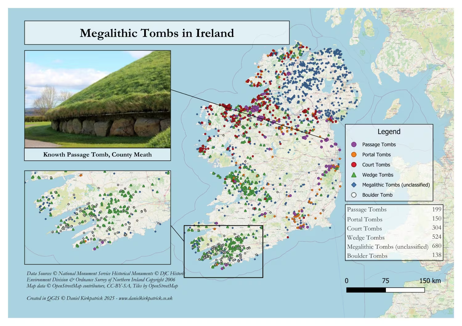
Map 1: Distribution of all Megalithic Sites in Ireland
Before making any assessment on a map, we must first consider what it is showing – the data. In this case, we have all classifications of megalithic tombs, from portal, boulder and passage tombs, to court and wedge tombs. You’ll also notice an unmistakable pattern of ‘blue’ in across the whole of Northern Ireland. This is because the data there doesn’t provide the same distinctions as we have available for the rest of Ireland. But that’s a good place to start.
The first thing to notice is the cluster in the north east up at the north coast. For those familiar with the history of this coastline, it won’t be particularly surprising. In fact, Ireland’s oldest known settlement – Mount Sandel, Coleraine – was discovered here, alongside one of the largest bronze age settlements – Corrstown Village, Portrush.
Other clusters can be seen near Enniskillen and near Omagh. Below Lough Neagh they appear comparatively fewer, as does around the Ards Peninsula. However, it’s worth being cautious about interpreting where we can’t see megalithic structures. For there are various issues with data quality which I’ll come on to below. But that’s enough for map one. Now we can move on to the more detailed maps.
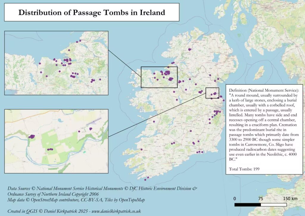
Map 2: Distribution of Passage Tombs across Ireland
A passage tomb is defined by the National Monument Service as a “round mound, usually surrounded by a kerb of large stones, enclosing a burial chamber, usually with a corbelled roof, which is entered by a passage, usually lintelled.” They typically date to an incredible 3,300 to 2,900 BC, though some – notably Carrowmore in Co. Sligo – are believed to date back to as far as 4,000BC. For reference, that’s when the kingdoms of Egypt and Sumeria were only beginning to become truly established.
For those even slightly familiar with Irish megaliths, this is likely the tomb you think of first when we refer to megaliths. The iconic World Heritage Site of Newgrange is one of the world’s most significant examples. In the map above you can see it cluster alongside a series of others in the Boyne Valley. The tour of Newgrange itself takes you around one of the other incredible examples of Knowth. At Knowth alone there is a cluster of 22 passage tombs, over 10% of all documented across Ireland – the total is 202 for the whole of the Republic of Ireland.
Other clusters can be seen just south of Sligo and again south of Dublin.
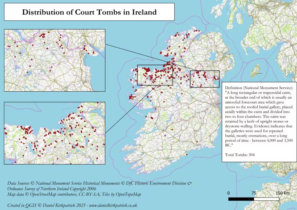
Map 3: Distribution of Court Tombs across Ireland
A court tomb is defined by the National Monument Service as a “long rectangular or trapezoidal cairn, at the broader end of which is usually an unroofed forecourt area which gave access to the roofed burial gallery, placed axially within the cairn and divided into two to four chambers.” These typically date to 4,000-3,500BC.
With 305 court tombs documented in the data for the Republic of Ireland, it’s hard not to notice their concentration in the north west and west of the island. One notable cluster is around Ballycastle, Co. Mayo, where there’s the Ballyglass court tomb. Further south there’s another cluster along the coastline. Here you can see examples like the Cleggan Court Tomb.
For those interested in learning more about Court Tombs you can check out this excavation report for the Court Tomb in Dunloy, Northern Ireland.
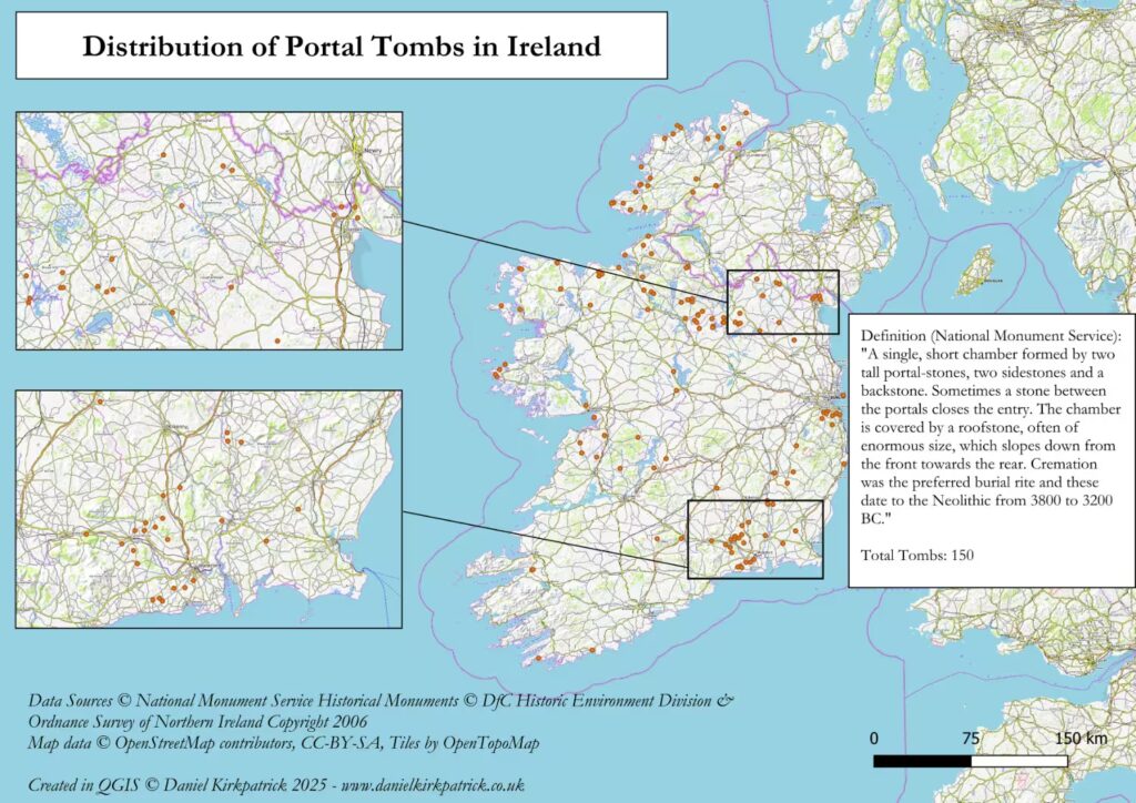
Map 4: Distribution of Portal Tombs across Ireland
A portal tomb is defined by the National Monument Service as a “single, short chamber formed by two tall portal-stones, two sidestones and a backstone.” These tombs date from 3,800 to 3,200 BC.
Their distribution follows a similar pattern to Passage Tombs above, but are the least prevalent of all tomb types with 150 mapped data points. There appear to be four clusters: one in the south surrounding Waterford; one in the east just south of Dublin; a band just below the border running east to west; and a cluster in the north west. I’ll focus on just on the last of these where I could see a particular concentration.
In Co. Donegal, off to the far north west, is a cluster of 6 portal tombs in close proximity with a further 3 nearby. This is the Malinmore Megalithic Cemetery, and they account for 4% of the total portal tombs in Ireland.
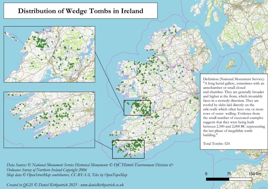
Map 5: Distribution of Wedge Tombs across Ireland
A wedge tomb is defined by the National Monument Service as a “long burial gallery, sometimes with an antechamber or small closed end-chamber. They are generally broader and higher at the front, which invariably faces in a westerly direction. They are roofed by slabs laid directly on the side-walls which often have one or more rows of outer- walling.” Wedge Tombs are estimated to date to between 2,500 and 2,000 BC making them the most recent of the above tomb classifications – a mere 4,000 years-old.
With 528 recorded examples, they are by far the most prevalent of all the megalithic tomb types. This suggests that this period – 2,500-2,000 BC – was when megalithic building was at its zenith. The techniques, materials, and social status of these monuments was likely at its peak.
From the above map you can see 3 clear clusters. There’s a cluster surrounding Sligo, much like for the other tombs. But it’s the clusters in the south-west and mid-west which are particularly interesting. For these two clusters appear to be relatively unique to this type of tomb. This may indicate changes in settlement patterns. But I’ll not venture any speculation beyond that as others are far better qualified to judge. Though this is a point which becomes stronger as we move on to the last tomb type – boulder tombs.
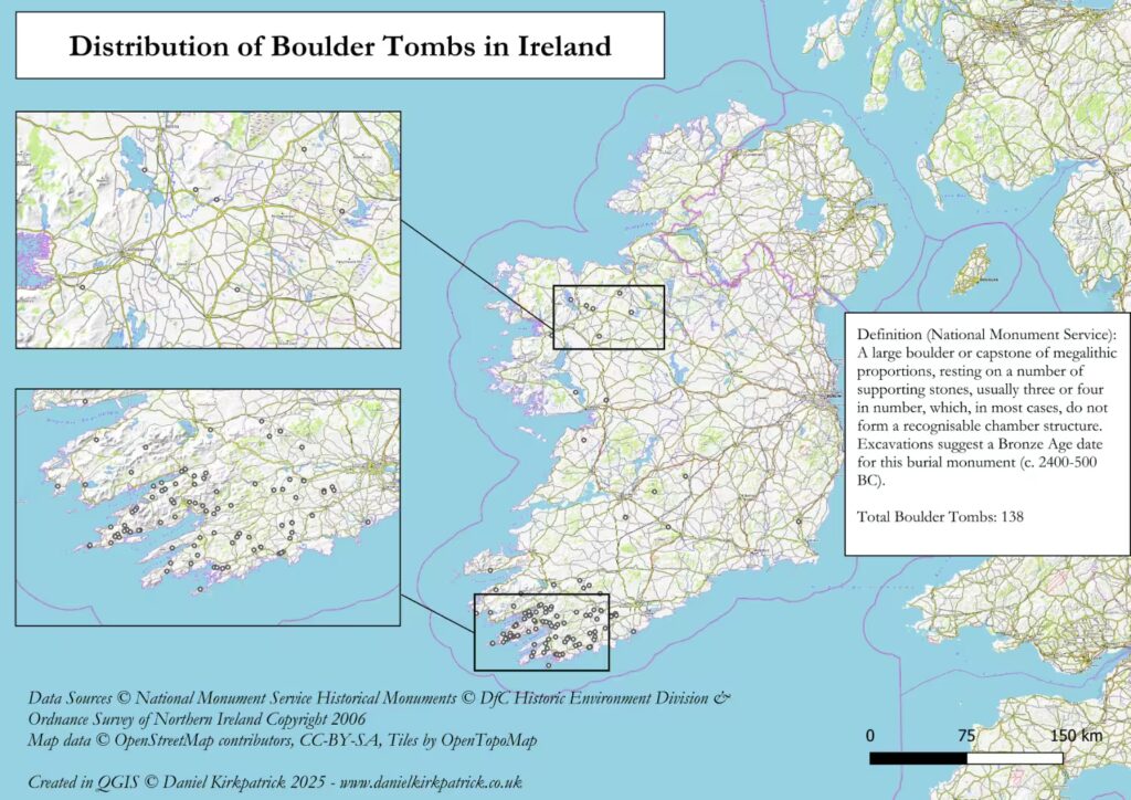
Map 6: Distribution of Boulder Tombs across Ireland
A boulder tomb is defined by the National Monument Service as a “large boulder or capstone of megalithic proportions, resting on a number of supporting stones, usually three or four in number, which, in most cases, do not form a recognisable chamber structure.” Dating of boulder tombs places them as the latest of all types, ranging from 2400-500 BC.
There are 141 recorded examples across the Republic of Ireland for Boulder Tombs (burials). But their concentration is almost exclusively in the south-west. Continuing a trend seen in wedge tombs, it appears that megalithic building become increasingly concentrated in this region as time progressed. Whether this means there was a decline in the northern regions, is unclear. But it is certainly interesting.
One academic study into these boulder tombs provides a clear summary of their use and function. It is worth quoting at length:
“The close spatial association between these monuments and stone circles argues that their function was largely of a ritualistic and probably commemorative nature, usually though possibly not always involving human burial.”2
This concludes the last of the megalithic tomb types. But it is crucial that any tentative assessment is caveated in the context of the data quality, coverage, and interpretation. Which brings us to the final section.
Megalithic Data Sources for Ireland
The two sources for data on megaliths across Ireland comes from the respective governments. In Northern Ireland this comes from the Department for Communities. It has mapped all known historical monuments across the 6 counties. All data is subject to ©DfC Historic Environment Division & Ordnance Survey of Northern Ireland Copyright 2006, which allows for reproduction so long as the source is acknowledged and the copyright notice included. However, it also suggests that the data was compiled back around the time of the copyright in 2006 (the website quality reinforces this view) and while the data is not going to change, it may not reflect new discoveries since that date. The granularity point has already been made regarding there not being a breakdown of megalithic structure categories.
For the Republic of Ireland, this data was compiled by the National Monument Service and doesn’t contain the same copyright restrictions. It also provides greater detail on monument types and lists out a data catalogue which helpfully defines each type (much of which I’ve referred above). There is an issue with some of the locations though where I had to remove several thousand which had incorrect longitude and latitude.
Beyond the data sources themselves, there are further important caveats to consider.
Data Quality Considerations
The absence of data doesn’t mean it was never there. This is important to remember particularly when discussing ancient data sources. First Ireland 6,000 years ago didn’t look like it does now. Our maps are a projection of the current geography on to an island (some even dispute whether it had yet become an island) which had different typologies. Rivers and waterways may have run in slightly different routes. Forests would have been much denser. The climate fluctuated over the millennia with academics already analysing its impact on cultural practices.
Then there’s the dark figure of history which has removed much of the archaeological evidence we rely on today. Agriculture, particularly ploughing, and the repurposing of materials for other needs has displaced much of history. Because this is an ‘known unknown’ it’s almost impossible to say how significant this has been, but it’s a key caveat to remember.
Lastly, there’s the problem of seeing these monuments simply as architectural structures. Yes their physical features obviously matter and clearly help us interpret them. But this can obscure away from the fact that they often underwent many phases of usage and practice, with significant periods of transformation. This means that the monuments we see today are not necessarily the same monuments that existed so many years ago. Some may have been redesigned, rebuilt, or simple removed.
All that said, I think we can and should try. The data is a fantastic resource and hopefully this post has at least inspired you a little.
- This post builds on my previous post which discussed the various types of ancient megaliths which is worth reading if you’re unsure about these distinctions (e.g. the differences between portal and wedge tombs). ↩︎
- O’Brien, W. I. L. L. I. A. M. “Boulder-burials: a later Bronze Age megalith tradition in south-west Ireland.” Journal of the Cork Historical and Archaeological Society 97 (1992): 11-35. ↩︎
YOU MAY ALSO LIKE
 Who is Manannán Mac Lir? Irish god of the Seas
  Battle of the Boyne Visitor Centre Review: History, Exhibits & Tips
  What is Navan Fort? The History of Emain Macha
 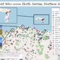 North Antrim Historical Sites: Interactive Map
  What was Bangor Abbey? Irish Medieval Monastic Hub
  What were the Irish war chariots?
  Tuatha Dé Danann: The 12 Legendary Irish Gods
  Book Review: A smaller social history of ancient Ireland, P.W. Joyce