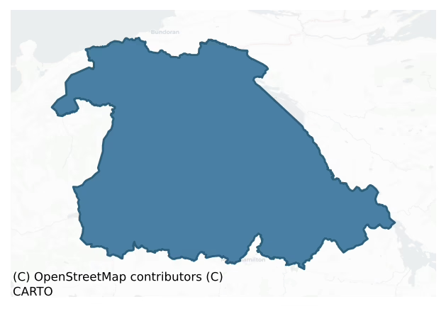
Rosclogher is a barony of County Leitrim, in the historical province of Connacht (Irish: Ros Clochair), covering 348 km² of land. The barony records 421 NMS archaeological sites and 44 NIAH listed buildings, placing it at around the 19th percentile among 280 ROI baronies for sites per km². This means it is in the bottom fifth of all baronies for sites per km². Dated archaeological evidence runs from the Neolithic through to the Post Medieval, spanning 7 of 9 archaeological periods, placing the barony in the 39th percentile among 280 ROI baronies for chronological depth. This means it is in the lower half of all baronies for chronological depth. The largest dated subset of recorded sites dates to the Early Medieval. Logainm flags 29 placenames in the barony as carrying a recognised heritage root; the largest share — around 41% — are names associated with pre-christian defensive.

Heritage at a glance
Percentile rankings throughout this profile compare each barony only against the other 279 Republic of Ireland baronies.
The recorded heritage of Rosclogher
The National Monuments Service Sites and Monuments Record (SMR) is the statutory inventory of archaeological sites for the Republic of Ireland, maintained by the Department of Tourism, Culture, Arts, Gaeltacht, Sport and Media. Sites recorded here include earthworks, ringforts, megalithic tombs, ecclesiastical remains, and post-medieval features; not every record is legally protected, but each is registered as a monument of archaeological interest.
The National Monuments Service records 421 archaeological sites in Rosclogher, putting it at the 19th percentile among 280 ROI baronies for sites per km². This means it is in the bottom fifth of all baronies for sites per km². Of these, 373 (89%) fall within a recorded monument protection zone. The dominant category is defensive sites — ringforts, enclosures, hillforts, and stone forts (197 sites, 47% of the record). Ringfort – rath is the most prevalent type, making up 22% of the barony's recorded sites (91 records), broadly in line with the ROI average of 20% across all baronies where this type occurs. Ringfort – rath is an earthen ringfort enclosed by a bank and external ditch — the most common Early Medieval farmstead, broadly dated 500–1000 AD. Other significant types include Ringfort – cashel (36) and Enclosure (30). Ringfort – cashel is the stone-walled equivalent of the rath, found mainly in upland or western areas, broadly dated 500–1000 AD; Enclosure is a banked or ditched feature of uncertain type, used as a catch-all where the original function cannot be determined from surface evidence. Across the barony's 348 km², this gives a recorded density of 1.21 sites per km².
Most common monument types
Hover or tap a monument type to see its definition.
| Type | Count |
|---|---|
| Ringfort – rath an earthen ringfort enclosed by a bank and external ditch — the most common Early Medieval farmstead, broadly dated 500–1000 AD | 91 |
| Ringfort – cashel the stone-walled equivalent of the rath, found mainly in upland or western areas, broadly dated 500–1000 AD | 36 |
| Enclosure a banked or ditched feature of uncertain type, used as a catch-all where the original function cannot be determined from surface evidence | 30 |
| Hut site a low stone or earthen foundation enclosing a small circular or oval area, generally interpreted as a former dwelling, of any date from prehistory to the medieval period | 24 |
| Standing stone a deliberately set upright stone, used variously as a Bronze/Iron Age burial marker, route marker or commemorative monument | 15 |
| Church a building used for public Christian worship, of any date from c. 500 AD onwards | 11 |
Chronological distribution
The dated archaeological record for Rosclogher spans from the Neolithic through to the Post Medieval, with activity attested across 7 of 9 archaeological periods. Every period from earliest to latest is represented in the record — an unbroken sequence of dated activity across the full chronological span. Activity concentrates most heavily in the Early Medieval (165 sites, 48% of dated material), with the Iron Age forming a secondary peak (77 sites, 22%). A further 76 recorded sites (18% of the overall NMS register for the barony) carry no period attribution — appearing as 'Unknown' in the bar chart below. This typically reflects either records that pre-date the standardised period vocabulary or sites awaiting specialist dating review, rather than a genuine absence of chronological evidence.
Sample of recorded monuments
Show 25 sample monuments (of 421 total)
A representative sample of 25 recorded monuments drawn from the barony’s 421 total NMS entries. Sites within a recorded monument protection zone and rarer site types are prioritised so the list shows a meaningful cross-section rather than only the most common type. Each entry shows the official Sites and Monuments Record reference number and the description published by the National Monuments Service.
Cross – High cross
On a small hillock in Tullaghan village. A plain upright Latin cross (dims of base 0.6m x 0.3m; H 3.21m) with slightly expanded arms is set in a chamfered sandstone base (dims 1.4m x 1.04m; H 0.87m). It leans slightly…
On a small hillock in Tullaghan village. A plain upright Latin cross (dims of base 0.6m x 0.3m; H 3.21m) with slightly expanded arms is set in a chamfered sandstone base (dims 1.4m x 1.04m; H 0.87m). It leans slightly to the W and was erected here in 1778 according to the inscription on its base, while local tradition maintains that the cross was found at the foreshore of Donegal Bay c. 300m to N (Wakeman 1896, 299). Archaeological testing (00E0486) in the vicinity failed to recover any archaeological features (Halpin 2002), as did testing (03E0504) c. 50m to the SE across the road (Timoney 2006), or immediately (05E0502) to the NE (Timoney 2008). (Crawford 1907, 213 14; O'Connell 1937, 208-10)
Described by Harbison (1992, vol. 1, 178) as 'A tall, ringless and undecorated cross, with straight arms but an expanding upper limb and a shaft tapering near the top, was uncovered by a sandstorm on the coast at Tullaghan and subsequently erected to the north of the new Sligo Bundoran road. It is about 4.25m high.’
The above description is derived from 'The Archaeological Inventory of County Leitrim' compiled by Michael J. Moore (Dublin: Stationery Office, 2003). In certain instances the entries have been revised and updated in the light of recent research.
See the attached view _1
Date of revised upload: 13 February 2017
Churchyard
Close to the S shore of Lough Melvin. A low earthen bank (int. H 0.2m; ext. H 0.9m) 21m to the E of the church (LE002-015001-), a scarp (H 1.8m) down to the lakeshore to the N and a slight bank to W form an enclosure…
Close to the S shore of Lough Melvin. A low earthen bank (int. H 0.2m; ext. H 0.9m) 21m to the E of the church (LE002-015001-), a scarp (H 1.8m) down to the lakeshore to the N and a slight bank to W form an enclosure (dims c. 45m E-W; c. 20-25m N-S) around the church but with no evidence of burial.
Compiled by: Michael Moore
Date of upload: 16 December, 2015
Road – road/trackway
Close to the S shore of Lough Melvin. A NW-SE roadway (L c. 100m) extending SE from the churchyard but associated with 19th century houses is marked on the 1835 ed. of the OS 6-inch map. It survives partly as a NW-SE…
Close to the S shore of Lough Melvin. A NW-SE roadway (L c. 100m) extending SE from the churchyard but associated with 19th century houses is marked on the 1835 ed. of the OS 6-inch map. It survives partly as a NW-SE field bank but it need not be ancient.
Compiled by: Michael Moore
Date of upload: 16 December, 2015
Moated site
Marked as a subrectangular hachured feature only on the 1907 ed. of the OS 6-inch map, and situated towards the bottom of a NE-facing slope at the S shore of Lough Melvin. It was described in the 1940s (SMR file) as a…
Marked as a subrectangular hachured feature only on the 1907 ed. of the OS 6-inch map, and situated towards the bottom of a NE-facing slope at the S shore of Lough Melvin. It was described in the 1940s (SMR file) as a rectangular area with rounded corners, which was defined by the lake-shore at N and principally by a fosse or moat ‘7 feet wide at W to 11 feet wide at E (Wth c. 2-3.3m)’ that had a depth of ‘3 feet 6 inches generally to 5 feet at E (D c. 1-1.5m)’. An internal bank had been leveled at S but rose steeply ‘5 feet 6 inches to 6 feet 6 inches (H c. 1.7-2m)’ from the bottom of the moat at E and W. However, its internal height was barely ‘6 inches to 1 foot 6 inches (int. H c. 0.15-0.45m)’. The monument has now been removed, but is visible as a grass-covered area (dims c. 40m NE-SW; c. 30m NW-SE) rising slightly above the general ground level. An earthen bank (Wth 4.2m; H 0.75m) with slight traces of an external fosse or moat survives at one point on the NW side. The church (LE001-015001-) is c. 50m to the W and the crannog (LE002-014001-) is c. 100m to the NNW.
The above description is derived from 'The Archaeological Inventory of County Leitrim' compiled by Michael J. Moore (Dublin: Stationery Office, 2003). In certain instances the entries have been revised and updated in the light of recent research.
Date of revised upload: 16 December 2015
Metalworking site
Iron slag was found on the N shore of Inisheen island in the 1940s within the Friars Garden (SMR file), which suggests that iron-working may have been practiced, but no slag was encountered on this occasion and the…
Iron slag was found on the N shore of Inisheen island in the 1940s within the Friars Garden (SMR file), which suggests that iron-working may have been practiced, but no slag was encountered on this occasion and the precise location of the original discovery is not known.
Compiled by: Michael Moore
Date of upload: 16 December, 2015
Field system
Located on an E-W ridge with rock outcrop and rough pasture at the top of a severe slope down to N, and overlooking Lough Melvin. Collapsed stone field walls covering about 12 acres (c. 4ha) create small rectangular…
Located on an E-W ridge with rock outcrop and rough pasture at the top of a severe slope down to N, and overlooking Lough Melvin. Collapsed stone field walls covering about 12 acres (c. 4ha) create small rectangular (dims c. 50m x c. 50m) or triangular fields centering on an enclosure (LE002-028002-). Five house-sites or hut-sites are within the fields.
The above description is derived from 'The Archaeological Inventory of County Leitrim' compiled by Michael J. Moore (Dublin: Stationery Office, 2003). In certain instances the entries have been revised and updated in the light of recent research.
Date of upload: 23 September 2008
Standing stone – pair
In pasture on the W-facing slope of a steep hill but below the steep incline of Arroo peak which rises over the location to the E. Two large sandstone uprights (N stone: dims 2m x 0.75m; max. H 2.4m; S stone: 1.9m x…
In pasture on the W-facing slope of a steep hill but below the steep incline of Arroo peak which rises over the location to the E. Two large sandstone uprights (N stone: dims 2m x 0.75m; max. H 2.4m; S stone: 1.9m x 0.6m; max. H 2.95m) are both aligned E-W and stand with their long sides just 0.8m apart. They may be part of a split boulder, and are incorporated into the wall of a sheep shelter (LE003-003001-). The wedge tomb (LE003-001001-) is situated c. 25m to the W.
The above description is derived from 'The Archaeological Inventory of County Leitrim' compiled by Michael J. Moore (Dublin: Stationery Office, 2003). In certain instances the entries have been revised and updated in the light of recent research.
Date of upload: 23 September 2008
Cupmarked stone
Situated on flat, low-lying ground c. 150m from the S shore of Lough Melvin and within the graveyard (LE005-003002-) of Rossinver church. A stone (Wth 0.5m; H 0.29m-0.33m plus; T 0.09m) with two cup-marks is re-used as…
Situated on flat, low-lying ground c. 150m from the S shore of Lough Melvin and within the graveyard (LE005-003002-) of Rossinver church. A stone (Wth 0.5m; H 0.29m-0.33m plus; T 0.09m) with two cup-marks is re-used as a headstone. (Weir 1980, 173-4)
See the attached image:
Compiled by: Michael Moore
Date of revised upload: 3 July, 2017
Bridge
This is a natural limestone bridge (Wth 6m; L 12m; Th 1.5m) spanning the ravine (D c. 2-3m) of the SE-NW County River between counties Leitrim and Fermannagh. It is the only easy natural crossing-point between Lough…
This is a natural limestone bridge (Wth 6m; L 12m; Th 1.5m) spanning the ravine (D c. 2-3m) of the SE-NW County River between counties Leitrim and Fermannagh. It is the only easy natural crossing-point between Lough Melvin c. 5.5 km to the NNW and Lough Macnean c. 6 km to the SE.
The above description is derived from 'The Archaeological Inventory of County Leitrim' compiled by Michael J. Moore (Dublin: Stationery Office, 2003). In certain instances the entries have been revised and updated in the light of recent research.
Date of upload: 23 September 2008
Cross
A fragment of a medieval window mullion in the graveyard (LE006-015002-) is the only indication of a church, but the head of a stone cross (Wth c. 0.75m; H c. 0.5m; T c. 0.2m) with a solid ring and a figure with…
A fragment of a medieval window mullion in the graveyard (LE006-015002-) is the only indication of a church, but the head of a stone cross (Wth c. 0.75m; H c. 0.5m; T c. 0.2m) with a solid ring and a figure with outstretched arms on both faces is thought to have been moved from here to the Roman Catholic church of Dromahair (NMI file), where it cannot now be found. This cross could be as late as the 17th century.
Compiled by: Michael Moore, Paul Walsh
Date of revised upload: 12 January 2016
Graveslab
There is a record of a stone with the carving of an animal called 'Dobhar Chu' (Tohall 1948, 127-9) in Kilroosk graveyard (LE007-018002-), which has many folk tales associated with it, but the stone has been missing…
There is a record of a stone with the carving of an animal called 'Dobhar Chu' (Tohall 1948, 127-9) in Kilroosk graveyard (LE007-018002-), which has many folk tales associated with it, but the stone has been missing since c. 1918. (Ruickbie 2016, 52)
Compiled by: Michael Moore
Date of upload: 25 January, 2016
Amended 24 June 2019
Bastioned fort
Situated on top of a hill on the floor of the WNW-ESE Glencar valley and close to its junction with the NW-SE Glenade valley. Manorhamilton castle and town are c. 2.5km to the ESE. Lurganboy had been established as a…
Situated on top of a hill on the floor of the WNW-ESE Glencar valley and close to its junction with the NW-SE Glenade valley. Manorhamilton castle and town are c. 2.5km to the ESE. Lurganboy had been established as a manor, probably at the time of the Plantation in the 1620s when it was owned by Thomas Abercrom (Mac an Ghalloglaigh 1966, 72 fn), but it belonged to James Wynne in the 1680s. A survey of c. 1683 describes ‘a good manor house, we a Bawn wherein the said James dwell’ (Logan 1971, 330). This might refer to this fort, although the fort seems to have played no part in the assaults on Manorhamilton during 1642-3, unless it was constructed by the Irish rebels (Mac an Gallóglaig 1966, 72-83).
This is a grass-covered square area (int. dims 61.5m NE-SW; 61.5m NW-SE) with some mature deciduous trees defined by an earthen bank (ext. H 0.6m) with three surviving diamond-shaped corner bastions (dims 13m x 9.5m) defined by earthen banks (int. H 0.55m; max. ext. H 3m) built on a battered masonry plinth at the E, S and W angels. The N bastion has been levelled. There is a subrectangular area (dims 15m x 12m) defined by earth and stone banks in the interior. A small modern church and graveyard enclosed within a mortared stone wall is built in the area of the N bastion. Archaeological testing (99E0313) in the vicinity failed to reveal any associated features (Quinn 2002).
The above description is derived from 'The Archaeological Inventory of County Leitrim' compiled by Mi…
House – fortified house
Situated on a slight rise about 200m NW of the original extent of Manorhamilton town (LE007-085—-) and separated from it by NE-SW section of the Owenbeg River. Sir Frederick Hamilton received a grant of over 5,000…
Situated on a slight rise about 200m NW of the original extent of Manorhamilton town (LE007-085—-) and separated from it by NE-SW section of the Owenbeg River. Sir Frederick Hamilton received a grant of over 5,000 acres in 1621-2 which he proceeded to increase, and by 1631 he had over 16,000 acres (Mac an Ghalloglaigh 1966, 59-60). He had undertaken to build a castle, which was probably not finished until 1636. In January 1642, Manorhamilton was besieged by Irish rebels under such leaders as Brian McDonogh and Owen O'Rourke or Teige O'Connor Sligo, who were encamped at Lurganboy. On January 30th they burnt the town but failed to capture the castle, and they lifted the siege on April 3rd (ibid. 72-5). In the following year Hamilton used the castle as a base for raids as far afield as Sligo and Donegal. Hamilton left Ireland in 1643-4 and died in Scotland in 1647, but the castle seems to have survived until it was burnt by the earl of Clanrickard in 1652 (ibid. 97).
The castle is a two or three-storey rectangular house (int. dims 20m E-W; 8m N-S), although most of the third storey does not survive. There are two wings (int. dims 7m N-S; 5.25m E-W) projecting on the N side which are not separated from the main house by party walls. The house is U-shaped and open to the N. The wings have a court (dims 8m N-S; 6.5m E-W) between them, but its S wall, which would have had the original doorway, does not survive. There is a sallyport which is partly below ground level at the cen…
Ceremonial enclosure
Situated on a slight NE-SW ridge on the lower NW-facing slope of Saddle Hill, and overlooking Lough Melvin which lies to the NE. This is a grass-covered circular area (int. diam. 113m N-S; 109m E-W) defined by an…
Situated on a slight NE-SW ridge on the lower NW-facing slope of Saddle Hill, and overlooking Lough Melvin which lies to the NE. This is a grass-covered circular area (int. diam. 113m N-S; 109m E-W) defined by an earthen bank (Wth 3m; H 0.3m) N-E, which is mainly reduced to a scarp elsewhere. The bank is separated by a fosse (Wth at S 4m; at E 7m) from an outer bank (Wth 3.2m; H 1.2m at N). A lane occupies the fosse NW-N-SE and there is a limestone standing stone (H 0.7m) which is probably not ancient in the NE quadrant of the enclosure. An original entrance is not identified. A ring-barrow (LE008-003—) and mound barrow (LE008-002—) are c. 80m to the NNE and c. 90m to the N respectively.
See the attached aerial view taken from the N.
The above description is derived from 'The Archaeological Inventory of County Leitrim' compiled by Michael J. Moore (Dublin: Stationery Office, 2003). In certain instances the entries have been revised and updated in the light of recent research.
Date of upload: 23 September 2008
Designed landscape – tree-ring
Depicted as a circular ring of trees but described as a 'fort' on the 1835 ed. of the OS 6-inch map, it is located on a slight rise on a W-facing slope. c. 120m SW of house described on the 1910 ed. of the 6-inch map as…
Depicted as a circular ring of trees but described as a 'fort' on the 1835 ed. of the OS 6-inch map, it is located on a slight rise on a W-facing slope. c. 120m SW of house described on the 1910 ed. of the 6-inch map as Lisnagroth Lodge. This is a circular area (int. diam. 16m) planted with mature deciduous trees, defined by an earth and stone bank (Wth 2.5m; int. H 0.3m; ext. H 0.9m), which is separated by a fosse (Wth 2.2m; D 0.25m) from an outer bank (Wth 2m; ext. H 1.1m) and slight outer fosse (Wth 1m; D 0.2m). It is probably a tree-ring.
The above description is derived from 'The Archaeological Inventory of County Leitrim' compiled by Michael J. Moore (Dublin: Stationery Office, 2003). In certain instances the entries have been revised and updated in the light of recent research.
Date of upload: 23 September 2008
Bullaun stone (present location)
In the porch of the Roman Catholic church at Tullaghan. Originally from a cashel at Doobally, probably (LE001-035—-), c. 1.3km to the ESE. This is a globular sandstone boulder (H 0.52m) which has a flat top (dims 0.58…
In the porch of the Roman Catholic church at Tullaghan. Originally from a cashel at Doobally, probably (LE001-035—-), c. 1.3km to the ESE. This is a globular sandstone boulder (H 0.52m) which has a flat top (dims 0.58 x 0.54m) with a single basin (diam. 0.35m; D 0.2m). There are traces of pecking in the basin and around the top of the stone, and it may have been used as a stoup. A limestone plaque (LE001-063002-) from the same ringfort has been installed on the wall of the porch. It has an incised inscription in Latin commemorating Rev. Eugene Magowan who founded a chapel in '177?'. (Ó Gallachair 1958, 28-9)
The above description is derived from 'The Archaeological Inventory of County Leitrim' compiled by Michael J. Moore (Dublin: Stationery Office, 2003). In certain instances the entries have been revised and updated in the light of recent research.
Date of upload: 23 September 2008
Cist
Situated at the summit of Saddle Hill. Two radially-set stones in the ring of the ring of ring-cairn (LE008-006001-) at WSW may indicate an entrance or a cist.
Compiled by: Michael Moore
Date of upload: 29…
Situated at the summit of Saddle Hill. Two radially-set stones in the ring of the ring of ring-cairn (LE008-006001-) at WSW may indicate an entrance or a cist.
Compiled by: Michael Moore
Date of upload: 29 January, 2016
Inscribed stone (present location)
A limestone plaque (dims 1m x 0.34-0.38m) from a ringfort in Doobally, probably (LE001-035—-), has been installed on the wall of the porch of Tullaghan Roman Catholic church. It is broken on the right-hand side and…
A limestone plaque (dims 1m x 0.34-0.38m) from a ringfort in Doobally, probably (LE001-035—-), has been installed on the wall of the porch of Tullaghan Roman Catholic church. It is broken on the right-hand side and has an incised inscription in Latin commemorating Rev. Eugene Magowan who founded a chapel in 177?. The bullaun stone (LE001-063001-) from the same location is also in the porch. The inscription reads: VOS OMNES QVI TRANSI (TIS OR) / ATE PRO REVERENDO PA (TR) / E EVGENIO MAGOWAN HVIVS (CAP) / PILLAE DONDITORE ANN (od) / …OMNI 177(?) (Ó Gallachair 1958, 28 9)
The above description is derived from 'The Archaeological Inventory of County Leitrim' compiled by Michael J. Moore (Dublin: Stationery Office, 2003). In certain instances the entries have been revised and updated in the light of recent research.
Date of revised upload: 11 December 2015
Burial
The meager remains of at least one adult and two children, probably post medieval in date, were found at a depth of c. 2m, and c. 30m to N of the cross (LE001-031001-) in 1997 (SMR file), but the exact location is not…
The meager remains of at least one adult and two children, probably post medieval in date, were found at a depth of c. 2m, and c. 30m to N of the cross (LE001-031001-) in 1997 (SMR file), but the exact location is not known.
Inscribed stone
The inscribed stone and the bullaun stone (LE001-063001-), which are now at Tullaghan Roman Catholic church (LE001-063002-), came from a fort in Doobally townland that was called Lisahurman fort, possibly this one. A…
The inscribed stone and the bullaun stone (LE001-063001-), which are now at Tullaghan Roman Catholic church (LE001-063002-), came from a fort in Doobally townland that was called Lisahurman fort, possibly this one. A limestone plaque (dims 1m x 0.34-0.38m) has an incised inscription in Latin commemorating Rev. Eugene Magowan who founded a chapel in 177?. (Ó Gallachair 1958, 28-9)
Compiled by: Michael Moore
Date of upload: 11 December, 2015
Building
Close to the S shore of Lough Melvin. There is a small square building (int. dims c. 3m x c. 3m) represented by a single wall (H 2m) and a pile of rubble c. 15m SE of the church (LE002-015001-).
Compiled by: Michael…
Close to the S shore of Lough Melvin. There is a small square building (int. dims c. 3m x c. 3m) represented by a single wall (H 2m) and a pile of rubble c. 15m SE of the church (LE002-015001-).
Compiled by: Michael Moore
Date of upload: 16 December, 2015
Booley hut
Located at the E edge of a broad plateau in rough pasture, and sheltering beneath rock outcrop that rises over it to the W. Two booley huts (int. dims 4.25m x 1.9m and 3.2m x 1.9m) defined by stone footings are…
Located at the E edge of a broad plateau in rough pasture, and sheltering beneath rock outcrop that rises over it to the W. Two booley huts (int. dims 4.25m x 1.9m and 3.2m x 1.9m) defined by stone footings are associated with a stone-walled field, a sheepfold and two rectangular enclosures (ext. dims 5m x 4.7m; 3.7m x 3.5m) defined by grass-covered stone spreads, which might also be booley huts.
The above description is derived from 'The Archaeological Inventory of County Leitrim' compiled by Michael J. Moore (Dublin: Stationery Office, 2003). In certain instances the entries have been revised and updated in the light of recent research.
Date of upload: 23 September 2008
Booley hut
In a hollow of exposed karst (dims c. 150m E-W; c. 100m N-S) on an E-facing slope. This is a rectangular area (int. dims 4.65m x 2.8m) defined by a collapsed drystone wall (Wth 0.7-0.8m).
The above description is…
In a hollow of exposed karst (dims c. 150m E-W; c. 100m N-S) on an E-facing slope. This is a rectangular area (int. dims 4.65m x 2.8m) defined by a collapsed drystone wall (Wth 0.7-0.8m).
The above description is derived from 'The Archaeological Inventory of County Leitrim' compiled by Michael J. Moore (Dublin: Stationery Office, 2003). In certain instances the entries have been revised and updated in the light of recent research.
Date of upload: 23 September 2008
Architectural fragment
Davies (1946b, 77) describes an architectural fragment (L 0.62m; H 0.26m; T 0.16-0.17m) with a portion of a trefoil-headed arcade in relief on it, which might have come from a tomb face, which is set up as a…
Davies (1946b, 77) describes an architectural fragment (L 0.62m; H 0.26m; T 0.16-0.17m) with a portion of a trefoil-headed arcade in relief on it, which might have come from a tomb face, which is set up as a grave-marker.
Compiled by: Michael Moore
Date of revised upload: 3 July, 2017
Ringfort – rath
On the N-facing slope of a low hill. Overgrown subcircular area (int. diam. c. 25m) defined by an earthen bank (at S: Wth 5.5m; int. H 0.15m) and external fosse (at S: Wth 4.4m; D 0.4m). A slight outer earthen bank (Wth…
On the N-facing slope of a low hill. Overgrown subcircular area (int. diam. c. 25m) defined by an earthen bank (at S: Wth 5.5m; int. H 0.15m) and external fosse (at S: Wth 4.4m; D 0.4m). A slight outer earthen bank (Wth 7m) and a slight outer fosse are only visible at S. There is a record from the 1940s of a possible hut site (diam. c. 6.5m) (LE002-007002-) at the centre (SMR file), which cannot be confirmed.
The above description is derived from 'The Archaeological Inventory of County Leitrim' compiled by Michael J. Moore (Dublin: Stationery Office, 2003). In certain instances the entries have been revised and updated in the light of recent research.
Date of upload: 23 September 2008
Listed buildings
The National Inventory of Architectural Heritage (NIAH) is a state survey appraising buildings of architectural, historical, archaeological, artistic, cultural, scientific, social, or technical interest. Each surveyed structure receives a rating from International (the highest, for buildings of European importance) through National, Regional, Local, and Record-Only.
The NIAH records 44 listed buildings in Rosclogher (20th percentile across ROI baronies). All recorded buildings carry Regional or lower grading; the barony does not contain any structures appraised as being of National or International architectural importance. Construction dates concentrate most heavily in the Victorian (1830-1900) period. The most-recorded building type is house (9 examples, 20% of the listed stock).
Terrain and environment
Mean elevation across the barony is 169m — the 92nd percentile among 280 ROI baronies for elevation. This means it is in the top tenth of all baronies for elevation. This is a relatively elevated landscape by ROI standards. Elevation matters for heritage because higher-altitude baronies typically favour defensive monuments — ringforts and hilltop forts placed on prominent ground — while lowland baronies are more likely to carry the dense settlement and church networks of intensive agricultural landscapes. The barony reaches 635m at its highest point — a vertical span of more than 466m within its boundary, indicating significant topographic diversity. Mean slope is 6.9° — the 91st percentile among 280 ROI baronies for slope. This means it is in the top tenth of all baronies for slope. This is consistently steep terrain by ROI standards, the kind of landscape that tends to preserve upstanding archaeological features well. Slope is a key control on both land use and archaeological preservation: steep ground resists ploughing and tends to preserve earthworks intact, while gentle slopes favour intensive cultivation that damages or destroys surface archaeology over time. Localised maximum slopes reach 18°, typical of stream-cut valleys, escarpments, or coastal bluffs within the wider landscape. The Topographic Wetness Index averages 9.7, the 11th percentile among 280 ROI baronies for wetness. This means it is in the bottom fifth of all baronies for wetness. This is well-drained ground by ROI standards — typical of upland or steeply-sloping country that sheds water rapidly. Drainage matters for heritage because poorly-drained ground preserves organic archaeology (wooden trackways, leather, textiles, and on rare occasions human remains) far better than free-draining soil; well-drained ground favours arable use but destroys organic material rapidly. The land-cover mosaic combines improved grassland (71%), woodland (23%), and open water (6%), giving a mixed agricultural and semi-natural landscape. In overall character, this is an upland landscape of steep, elevated terrain, with land use dominated by improved grassland.
Terrain measurements
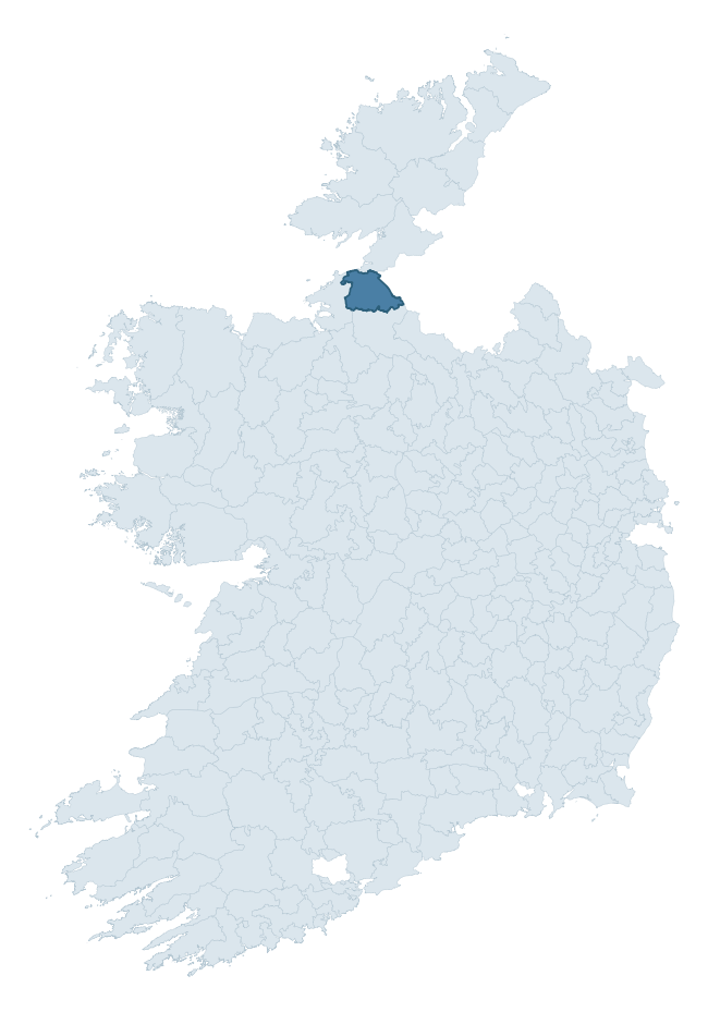
Where this barony sits in the Republic of Ireland
Geology and preservation
Bedrock geology shapes the landscape long before any settlement begins — controlling soil drainage, agricultural potential, the survival of upstanding monuments, and the preservation of buried archaeology. The figures below come from the Geological Survey Ireland 1:100,000 bedrock map.
The bedrock underlying Rosclogher is predominantly sandstone (31% of the barony by area), laid down during the Carboniferous period (97% by area, around 359 to 299 million years ago). Sandstone weathers to free-draining, moderately fertile soils that supported Early Medieval ringfort agriculture and later manorial estates. The rock itself is a major source of building stone — visible in churches, tower houses, and farm buildings across the barony's historic landscape. A substantial secondary geology of limestone (29%) and shale (22%) adds further variety to the underlying landscape. The single largest mapped unit is the Dartry Limestone Formation (28% of the barony's bedrock). With 7 distinct rock types mapped, the barony sits in the top third of ROI baronies for geological diversity (74th percentile) — typically a sign of complex tectonic history or coastal mosaics of differing rock units.
Rock type composition
Largest mapped unit: Dartry Limestone Formation (28% of the barony)
Placename evidence
Logainm records 29 heritage-diagnostic placenames for Rosclogher, drawn from townland and civil-parish names across the barony. The dominant stratum is pre-Christian and Early Medieval defensive — ráth-, lios-, dún-, and caiseal-prefixed names that mark Iron Age and early historic settlement. The leading diagnostic roots are cill- (8 — church), ráth- (4 — earthen ringfort), and lios- (3 — ringfort or enclosure). This is broadly in line with the ROI average of 30.7 heritage placenames per barony. The presence of multiple heritage strata side by side indicates layered occupation of the landscape across successive prehistoric and historic periods. Logainm records 221 placenames for Rosclogher (predominantly townland names). Of these, 29 (13%) carry one of the diagnostic Gaelic roots tracked above; the remainder draw on more generic landscape vocabulary that does not encode a heritage period.
Pre-Christian / Early Medieval Defensive
| Root | Count | Meaning |
|---|---|---|
| ráth- | 4 | earthen ringfort |
| lios- | 3 | ringfort or enclosure |
| dún- | 3 | hilltop or promontory fort |
| caiseal- | 2 | stone ringfort |
Early Christian Ecclesiastical
| Root | Count | Meaning |
|---|---|---|
| cill- | 8 | church (early) |
| teampall- | 3 | church (later medieval) |
Burial, Ritual, and Norse-Contact
| Root | Count | Meaning |
|---|---|---|
| tuaim- | 1 | burial mound |
| carn- | 1 | cairn |
| feart- | 1 | grave mound |
| leacht- | 1 | grave monument |
| sián- | 1 | fairy mound |
| uaimh- | 1 | cave / souterrain |
Other baronies in Leitrim
About this profile
Click any section below to expand.
What is a barony?
A barony is a historic administrative unit in Ireland, broadly equivalent to an English hundred. The 280 baronies used here are from the OSi 2019 National Statutory Boundaries (generalised 20m), covering the 26 counties of the Republic of Ireland. Baronies derive from the Norman period, were formalised in the 17th century, and have not been redrawn for statistical purposes. They vary enormously in area, from compact urban baronies in Dublin to vast upland baronies in Connacht, and should not be compared by raw site count without accounting for area differences.
What counts as a site?
This profile combines three distinct heritage registers, each with its own definition of what constitutes a recordable site:
- Archaeological sites (NMS). The National Monuments Service Sites and Monuments Record (SMR) catalogues every known archaeological monument or site of archaeological interest in the Republic, from prehistoric burial mounds and ringforts to medieval churches and post-medieval defensive works. Inclusion does not require legal protection — only that the site has been identified, surveyed, and assessed as having archaeological value. A separate subset of these sites lies within a recorded protection zone, which gives them statutory protection under the National Monuments Acts.
- Listed buildings (NIAH). The National Inventory of Architectural Heritage records buildings of architectural, historical, archaeological, artistic, cultural, scientific, social, or technical interest. Each surveyed structure is appraised on a five-tier scale: International, National, Regional, Local, and Record-Only. The NIAH appraisal is informational rather than strictly statutory, but it underpins local-authority Record of Protected Structures (RPS) listings.
- Heritage placenames (Logainm). Logainm is the authoritative database of Irish placenames maintained by the Placenames Branch. This profile applies a heritage-diagnostic classifier to the Irish-language form of each townland name, flagging roots that signal defensive sites (ráth-, lios-, dún-, caiseal-, cathair-), ecclesiastical foundations (cill-, teampall-, domhnach-, mainistir-), prehistoric burial-ritual features (tuaim-, carn-, leaba-), or Norse-contact settlement (gall-). Townlands without one of these diagnostic roots are not flagged here — they may still carry historical significance, but that significance is not encoded in the name itself.
Editorial principles
The narrative sections of this profile follow several explicit principles:
- Evidential. Every claim about this barony’s heritage character is anchored in the underlying register data. Where a site count, a placename count, or a percentile rank is cited, it is computed from the source datasets at export time, not estimated.
- Comparative. Counts and metrics are reported alongside their percentile rank against the other 279 ROI baronies. A barony with 50 ringforts in absolute terms could be unusually high or unusually low depending on its size and regional context; percentile ranking removes that ambiguity.
- Transparent on limits. Where a register has known coverage gaps, survey biases, or data-quality issues that affect this barony’s figures, the profile flags them rather than presenting the numbers as definitive.
- No interpretation beyond what the data supports. The narrative does not speculate about historical events, social dynamics, or cultural meaning beyond what the recorded heritage and placename evidence directly attests.
Data caveats and limits
- NMS Sites and Monuments Record is the product of survey campaigns conducted at different intensities across different counties and decades. Some baronies have been surveyed more thoroughly than others, and absolute counts should be read in that light. Sites destroyed by development before survey are typically not represented; sites in heavily forested or upland terrain are sometimes under-recorded.
- NIAH coverage is broadly complete for the Republic of Ireland but the survey was conducted on a rolling county-by-county basis, and the most recent appraisal date varies. Buildings demolished or substantially altered after their original survey may still appear in the register; conversely, recent buildings of merit may not yet have been appraised.
- Logainm classification applies a deliberately conservative pattern-matching approach to the Irish-language townland forms. The classifier prioritises true positives over recall: a townland may carry a heritage signal that the classifier doesn’t recognise, particularly where the diagnostic root has been heavily anglicised or where the townland name draws on a less common term. The 60,000+ townland records and ~9,800 classified placenames give a substantial signal at barony scale, but individual townland names should be checked against Logainm directly for definitive interpretation.
- Period attribution. The chronological distribution reflects only those NMS sites that carry a recognised period attribution in the source data. Sites listed as “Unknown” period are excluded from the dated subset.
- Boundary changes. Some baronies have undergone minor boundary adjustments since their 19th-century definition; the OSi 2019 generalised boundaries used here are the current statutory definition and may differ slightly from historical maps in border areas.
- Bedrock geology is mapped at 1:100,000 scale, which means local variation within a barony — small pockets of different rock type, mineral veins, alluvium overlying bedrock — is generalised. The dominant-system and rocktype figures are area-weighted, so a barony reading “70% Carboniferous limestone” may still contain small but archaeologically important pockets of older or younger rock. Around 3% of GSI polygons do not match the lexicon and contribute no rocktype or system attribution.
Data sources
- National Monuments Service — Sites and Monuments Record (SMR) https://data.gov.ie/dataset/national-monuments-service-archaeological-survey-of-ireland
- National Inventory of Architectural Heritage (NIAH) https://data.gov.ie/dataset/national-inventory-of-architectural-heritage-niah-national-dataset
- Logainm — Placenames Database of Ireland https://www.logainm.ie/
- Ordnance Survey Ireland — National Statutory Barony Boundaries 2019 https://data-osi.opendata.arcgis.com/
- EURODEM — European Digital Elevation Model https://www.mapsforeurope.org/datasets/euro-dem
- ESA WorldCover https://esa-worldcover.org/en
- Geological Survey Ireland — 1:100,000 Bedrock Geology https://www.gsi.ie/en-ie/data-and-maps/Pages/Bedrock.aspx
Explore more: Search any of the 280 ROI baronies, browse by historical province, or read the methodology and data sources for the full Republic of Ireland Heritage Tool.