When you visit the great sporting arenas and concert halls of today, or the iconic amphitheatres of Roman and Greek history, they rightly can feel overwhelming – positively so. These great gathering spaces are designed to both fill us with awe, but also bring us together. But while these modern and ancient examples are well known, henges were one of the earliest known examples of just this. Some of these gigantic earthen embankments date back over 4,000 years and would have had a variety of functions in bringing peoples together. The exact usage and purpose remains the subject of debate, but in nearly all of these gathering is a common theme. The purpose (funerary, ritualistic, entertainment, political, economic) is disputed. But this post is about not only what they were, and what they were for, but also where you can find them. Here you can see an interactive map of all recorded sites alongside a case study to help contextualise this.
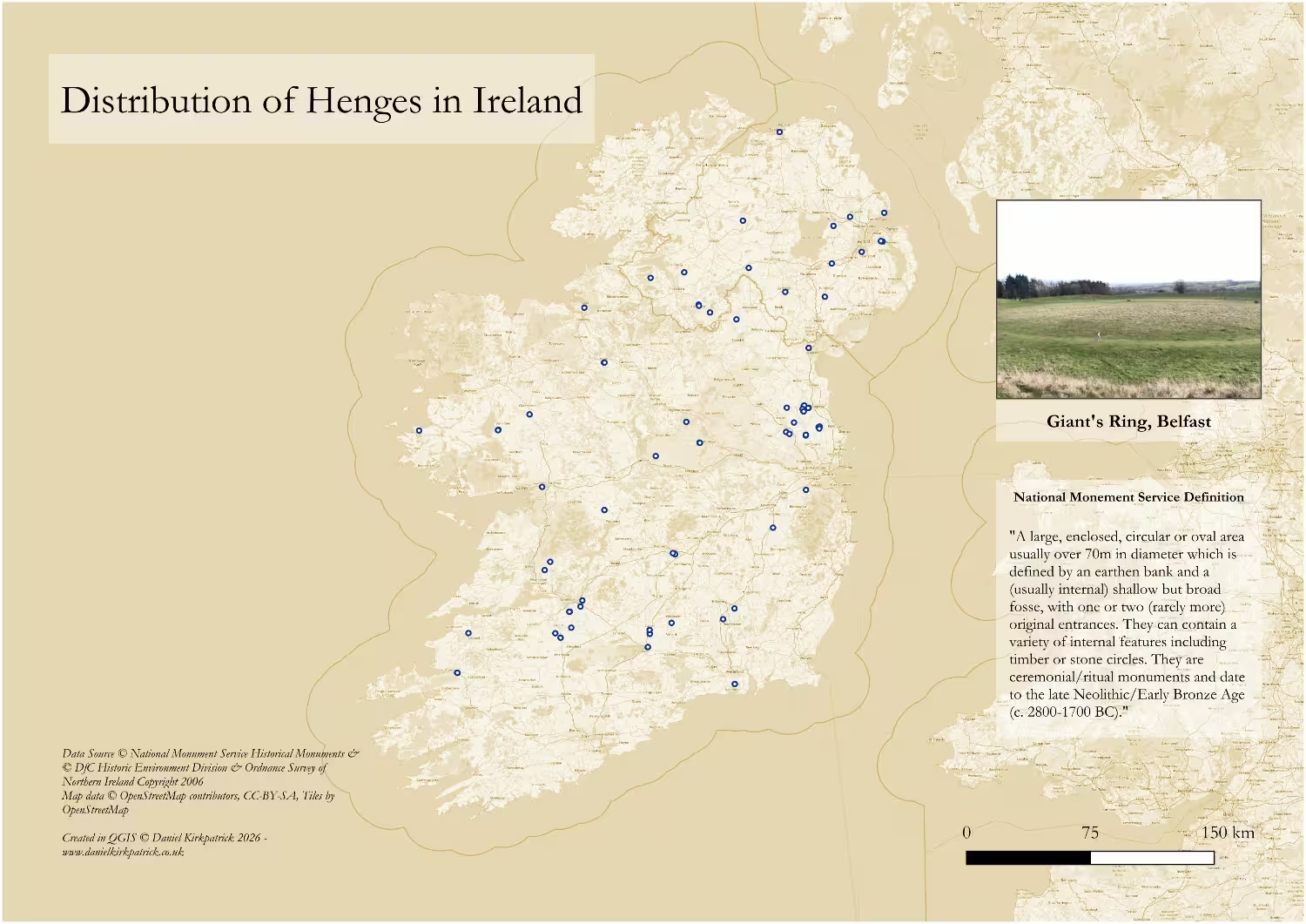
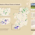
Interactive Map of Henge Locations in Ireland
Interactive Map of Henges
Click to view all recorded Henge locations across Ireland.
This interactive map was created in ArcGIS Online using data from both Government datasets. The data was originally cleaned in Excel using PowerQuery and then in QGIS. It includes all henge locations recorded by either government using filters for classification and description. Copyright for the data and basemaps attribution is as follows:
Data Sources
© National Monument Service Historical Monuments
© DfC Historic Environment Division & Ordnance Survey of Northern Ireland Copyright 2006
Map data
© OpenStreetMap contributors, CC-BY-SA, Tiles by OpenStreetMap
What is a Henge?
The National Monument Service for Ireland defines holy wells as:
“A large, enclosed, circular or oval area usually over 70m in diameter which is defined by an earthen bank and a (usually internal) shallow but broad fosse, with one or two (rarely more) original entrances. They can contain a variety of internal features including timber or stone circles. They are ceremonial/ritual monuments and date to the late Neolithic/Early Bronze Age (c. 2800-1700 BC).”
So in plain terms, henges all will have a huge circular earthen bank. Many of these banks have been ploughed away, but often show up in remaining cropmarks. There will be some sort of ‘entrance’ where basically the banks dip down to ground level. The size is important to distinguish these from the many smaller and later earthen enclosures typical of ringforts. This makes them much more unique.
It’s also worth noting the importance of their dating, for this means that the builders would have been using stone/flint tools to create such sites. Not only does this suggest a high degree of organisation across the population at this time, but also sufficient surplus labour to extend on such building projects. These were sophisticated communities who went to great lengths to build these sites. Which begs the next question – why? To answer this, let’s turn to one of the best known examples, the Giant’s Ring.
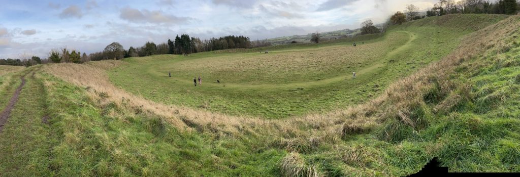
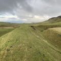
Giant’s Ring Henge, Belfast
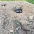
I’ve written at length about the Giant’s Ring before, and with good reason. It is genuinely remarkable. Most who visit it have their eyes drawn to its centre where a small dolmen now stands (once likely a passage tomb), largely because we are used to embankments today across the many farms in Ireland. But where it takes a matter of days to create such features now with heavy machinery, in the neolithic and bronze ages it would have been months (likely years) of work involving whole communities using stone or bone tools. And archaeological finds at the Giant’s Ring shed some light on why.
First are the wide range of prehistoric burial sites nearby. Cists, cairns, tombs, can all be found in the neighbouring field. This is typical of such sites. But there was also an intriguing wooden building recently discovered which suggests temporary occupation of the site. Archaeologists believe it may have once been used for gathering at key events within the seasonal calendar. In this sense, the site’s permanent residents were only the deceased. And prehistoric communities instead saw this as a key meeting place for important events. What these events consisted of still remains debated, but their setting here clearly mattered.
Which brings us next to where you can find them.
Where can you find henges in Ireland?
The first thing to note is just how few remain. Sadly most henges have been destroyed as a result of ploughing and agriculture. Their size and position nearly always clashed with farming practices, often blocking rich arable land-use. Thankfully advances in drone technology and scanning, are beginning to reveal more markers, but it remains a known problem.
That said, there is one significant cluster worth explaining in the Boyne Valley. The valley is widely known for it UNESCO World Heritage site – Newgrange. But beside these iconic megalithic tombs, there are (often hidden in plain sight) an array of henges along the fertile banks of the river Boyne.
Whether this location was chosen for practical reasons (beside a key waterway) or spiritual (river worship was widely practiced), it is likely impossible and unnecessary to distinguish. The point is location was perceived as significant and so much so that they built not one, but several gigantic earthen rings (there’s also evidence of possible timber ones too).
So I hope this post encourages you to go and explore too. These sites are were built for awe, for reverence, and to draw peoples together. Let’s continue that tradition today.
Data Caveats and Considerations
The data on holy wells should be caveated with a few common quality issues. First is the coverage, whereby a lot of sites have been destroyed or lost to history. This is a common challenge for any archaeological sites. Then there is the data consistency as I’ve joined data from Northern Ireland with that in the Republic. While the National Monument Service data has a specific classification for henges, the data for Northern Ireland is more inconsistent. There will therefore likely be a few false positive alongside a few missed sites. You can select individual sites in the interactive map, however, to see exactly what they refer to.
Frequently Asked Questions: Stone Circles in Ireland
Estimates suggest there are around 32 henges recorded across the island. But the actual figure is likely many times this due to site destruction as a result of ploughing and land clearance.
Most date to the late Neolithic/Early Bronze Age (2800-1700 BC)
They were used for ceremonial and ritual purposes, as great gathering places.
YOU MAY ALSO LIKE
 Manannán Mac Lir: Irish God of the Sea — Myth, Power & Legacy
 North Antrim Historical Sites: Interactive Map
 Bullaun Stones of Ireland: Mapping the Sacred Basins
 Barrows of Ireland: Mapping Ireland’s Prehistoric Burial Mounds
 Stone Circles in Ireland
 Viking Settlements in Ireland: From Raids to Norse Towns
 Buildings in Iron Age Ireland: Roundhouses, Ringforts & Crannógs
 Iron Age Food and Drink: History and significance of diet in ancient Ireland