346 historic sites19 scheduled monuments62 listed buildings8 archaeological periods
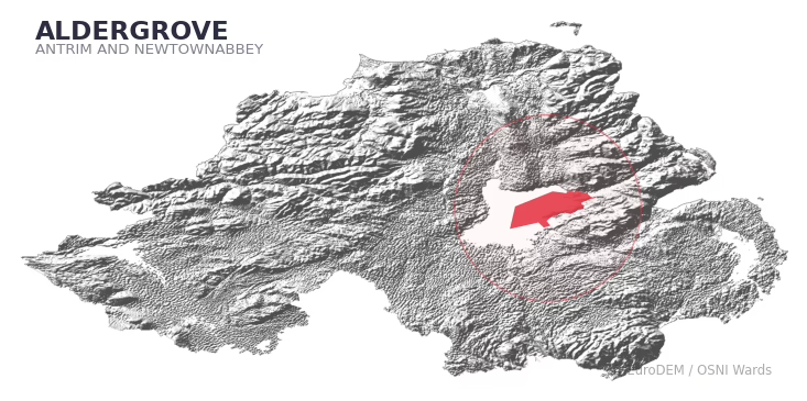
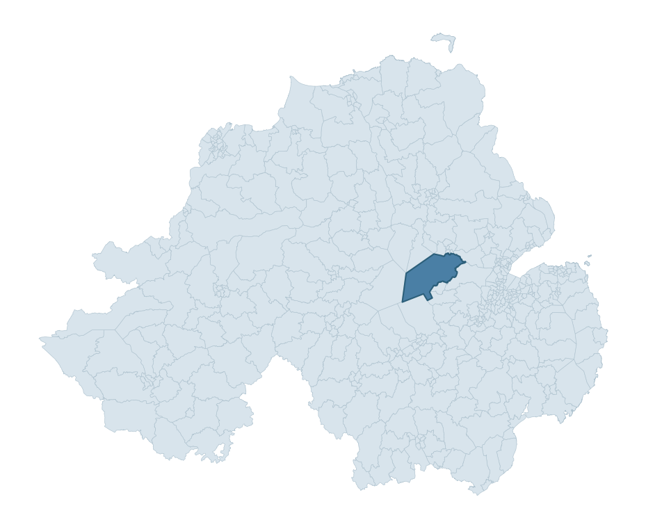
ALDERGROVE covers 465.0 km² in Northern Ireland. With 346 historic sites and 19 scheduled monuments on record, the ward sits at the 99th percentile across all 462 NI wards for combined archaeological heritage. It also records 62 listed buildings (HED Historic Buildings Record), the 83rd percentile for listed-building density across NI wards. Per 1,000 residents, this works out at 106.7 recorded sites — the 99th percentile across NI wards (a measure of heritage density relative to current population). Dated archaeological evidence runs from the Mesolithic through to the Modern period, spanning 8 archaeological periods, placing the ward in the 90th percentile NI-wide for chronological depth.
ALDERGROVE boundary detailALDERGROVE in regional context
Heritage at a glance
Percentile rankings throughout this profile compare each ward only against the other 461 Northern Ireland wards.
346
Historic sites
99th percentile
19
Scheduled monuments
95th percentile
62
Listed buildings
83rd percentile
0.92
Sites per km²
Population context
9
Persons per km²
4th percentile
106.7
Sites per 1,000 residents
99th percentile
4,001
Total residents (2021)
The recorded heritage of ALDERGROVE
Of the 346 historic sites recorded, the most common are Enclosure (Chart) (126, 36% of historic sites), Enclosure (42), and Rath (26). For Enclosure (Chart)s, this is the 75th percentile across NI wards that record this type. For Enclosures, this is placing the ward in the top 1% nationally for this type. Across the ward's 465.0 km², this gives a recorded density of 0.92 sites per km² (all heritage types combined). Scheduled monuments are distributed across approximately 0.12° of latitude and 0.15° of longitude within the ward, indicating dispersed rather than clustered placement.
Most common monument types
Type
Count
Description
Enclosure (chart)
126
—
Enclosure
42
—
Rath
26
—
Chronological distribution
Mesolithic
9
Neolithic
1
Early Bronze Age
1
Iron Age
179
Early Medieval
99
Medieval
7
Post Medieval
11
Modern
8
Unknown
31
Terrain and environment
Mean elevation of 32m sits around the NI median (25th percentile), reaching 126m at the highest point. The terrain is broadly flat, with a mean slope of 1.1° (0th percentile across NI). Drainage is poor across much of the ward — the Topographic Wetness Index of 12.9 sits in the 99th NI percentile, reflecting low-lying or impeded-drainage ground prone to waterlogging. The land cover is dominated by open water (55%) and improved grassland (36%). In overall character, this is low-lying, gently-sloping terrain — characteristic of NI's lowland basins and coastal plains, with land use dominated by open water.
Terrain measurements
Mean elevation31.6 m 25th pct
Max elevation126.5 m 54th pct
Mean slope1.1° 0th pct
Wetness index (TWI)12.91 100th pct
Grassland36.5% 36th pct
Woodland4.5% 2nd pct
Cropland1.9% 59th pct
Urban land2.2% 29th pct
Where this ward sits in NI
Elevation
25th
Slope
0th
Drainage
100th
Grassland
36th
Woodland
2nd
Geology and preservation
The dominant bedrock formed during the Cainozoic era (Palaeogene period). Relatively young rock formed in the last 66 million years. In Ulster, Cainozoic basalt — the lava that created the Antrim Plateau and Giant's Causeway — dominates much of the eastern landscape. Bedrock composition is varied (complexity index 0.90, on a 0-1 Simpson-style scale), with multiple geological units within the ward boundary. Geologically diverse wards historically offered a wider range of stone types for building, toolmaking, and quarrying — a relevant factor when interpreting the material culture of nearby sites.
Bedrock eraCainozoic
Bedrock periodPalaeogene
Surface depositsDrift Geology Not Mapped [for Digital Map Use Only]
Peat coverage0.0%
Bedrock complexity0.90
Placename evidence
The combined OSNI, Logainm NI, and GeoNames sources record 59 placenames for this ward. Diagnostic heritage strata identified within these are: 1 pre-Christian defensive (rath-, dún-, lios-, caiseal-) and 4 ecclesiastical (cill-, teampall-, mainistir-, díseart-). Note: Irish-language (name_ga) forms are recorded for roughly half of NI placenames in the combined sources, so anglicised forms whose Irish original could belong to multiple categories may be misclassified.
Placename categories
Ecclesiastical (kil-, temple-, monaster-)4 names
Pre-Christian Defensive (rath-, dun-, lis-)1 name
Scheduled monuments in ALDERGROVE
Scheduled monuments are sites legally protected under the Historic Monuments and Archaeological Objects (Northern Ireland) Order 1995, designated by the Historic Environment Division (HED).
Monument
Type
Period
Church (site of)
Church (Site Of)
Unknown
Motte
Motte
Medieval
Rath and souterain: Bog Head
Rath And Souterain: Bog Head
Early Medieval
Rath
Rath
Early Medieval
Rath and Motte
Rath And Motte
Early Medieval
Platform rath
Platform Rath
Early Medieval
Barrow
Barrow
Early Bronze Age
Motte and bailey and later enclosure : Bull Mount
Motte And Bailey And Later Enclosure : Bull Mount
Iron Age
Round tower
Round Tower
Early Medieval
Rath
Rath
Early Medieval
Mound
Mound
Unknown
Rath Group
Rath Group
Early Medieval
Rath
Rath
Early Medieval
Bivallate rath
Bivallate Rath
Iron Age
Rath
Rath
Early Medieval
Bivallate Rath
Bivallate Rath
Iron Age
Conjoined rath 'Bean Fort'
Conjoined Rath 'Bean Fort'
Early Medieval
Bullock Fort
Bullock Fort
Unknown
Ogham Stone
Ogham Stone
Early Medieval
Recorded historic sites
Name
Period
Type
A.P. SITE – ENCLOSURE
Iron Age
Unknown
A.P. SITE – MOUND
Unknown
Unknown
A.P. SITE – RATH
Early Medieval
Defence
A.P. SITE – circular cropmark
Unknown
Unknown
A.P. SITE – circular cropmark
Unknown
Unknown
A.P. SITE – circular cropmark
Unknown
Unknown
A.P. SITE – circular cropmark
Unknown
Unknown
A.P. SITE – circular cropmark
Unknown
Unknown
A.P. SITE – circular cropmark
Unknown
Unknown
A.P. SITE – circular cropmark
Unknown
Unknown
A.P. SITE – circular cropmark
Unknown
Unknown
A.P. SITE – circular cropmark
Unknown
Unknown
A.P. SITE – circular cropmark
Unknown
Unknown
A.P. SITE – circular cropmark
Unknown
Unknown
A.P. SITE – circular cropmark
Unknown
Unknown
A.P. SITE – circular cropmark
Early Medieval
Unknown
A.P. SITE – circular cropmark – Bivallate Rath?
Iron Age
Defence
A.P. SITE – circular cropmark – Rath?
Early Medieval
Defence
A.P. SITE – circular cropmarks – Rath Pair with Ant 050:171?
Early Medieval
Defence
A.P. SITE – circular enclosure
Iron Age
Unknown
A.P. SITE – circular enclosure
Iron Age
Unknown
A.P. SITE – circular enclosure – possibly forming Rath Pair with Ant 050:152
Iron Age
Defence
A.P. SITE – elliptical cropmark
Unknown
Unknown
A.P. SITE – enclosure
Iron Age
Unknown
A.P. SITE – enclosure?
Iron Age
Unknown
A.P. SITE – hexagonal cropmark
Unknown
Unknown
A.P. SITE – large circular cropmark
Unknown
Unknown
A.P. SITE – small circular cropmark
Unknown
Unknown
A.P. SITE – small circular cropmark – Barrow?
Early Bronze Age
Ritual/Funerary
AP Cropmark- Possible rath
Early Medieval
Defence
AP Cropmark- Possible rath or enclosure
Iron Age
Defence
AUGUSTINIAN PRIORY SITE
Early Medieval
Religious
BARROW
Mesolithic
Ritual/Funerary
BIVALLATE RATH
Early Medieval
Defence
BIVALLATE RATH
Early Medieval
Defence
BIVALLATE RATH
Early Medieval
Defence
BIVALLATE RATH
Early Medieval
Defence
BIVALLATE RATH
Early Medieval
Defence
BIVALLATE RATH
Early Medieval
Defence
BIVALLATE? RATH
Early Medieval
Defence
CASTLE?: OLDSTONE HILL (unlocated)
Post-Medieval
Defence
CASTLE?: SIR NIALL O'NEILL'S CASTLE, THE LODGE
Post-Medieval
Defence
CHURCH & GRAVEYARD (site of): CAPELLA DE ELDER (unlocated)
Unknown
Ritual/Funerary
CHURCH & GRAVEYARD (site of): ROBERTSTOWN
Medieval
Ritual/Funerary
CHURCH & GRAVEYARD: GARTREE CHURCH, KILMACHEVET, TREMFADE
Post-Medieval
Ritual/Funerary
CHURCH (site of) & GRAVEYARD
Post-Medieval
Ritual/Funerary
CHURCH; BULLAUN: KILLEDE or KILLELAGH or DALNACH?
Early Medieval
Religious
COUNTERSCARP RATH – ONE OF A PAIR WITH ANT 054:001
Early Medieval
Defence
COUNTERSCARP PLATFORM RATH
Early Medieval
Defence
COUNTERSCARP RATH
Early Medieval
Defence
COUNTERSCARP RATH
Early Medieval
Defence
COUNTERSCARP RATH
Early Medieval
Defence
COUNTERSCARP RATH reused as MOTTE & BAILEY with LATER ENCLOSURE: BULL MOUNT
Early Medieval
Defence
COURT TOMB
Mesolithic
Ritual/Funerary
Conjoined enclosures/ rath pair
Early Medieval
Defence
DESERTED VILLAGE
Medieval
Domestic
EARLY CHRISTIAN MONASTERY; ROUND TOWER; CHURCH SITE: ENIS-GARDEN or INIS-GARDEN or INIS-DRAICRENN or INIS-DAIRCAIRGREN or THE CHURCH OF LENNEWY?
Early Medieval
Religious
ENCLOSURE
Iron Age
Unknown
ENCLOSURE
Iron Age
Unknown
ENCLOSURE
Iron Age
Unknown
ENCLOSURE
Iron Age
Unknown
ENCLOSURE
Iron Age
Unknown
ENCLOSURE
Iron Age
Unknown
ENCLOSURE
Iron Age
Unknown
ENCLOSURE
Iron Age
Unknown
ENCLOSURE
Iron Age
Unknown
ENCLOSURE
Iron Age
Unknown
ENCLOSURE
Iron Age
Unknown
ENCLOSURE
Iron Age
Unknown
ENCLOSURE
Early Medieval
Unknown
ENCLOSURE
Iron Age
Unknown
ENCLOSURE
Iron Age
Unknown
ENCLOSURE
Iron Age
Unknown
ENCLOSURE
Iron Age
Unknown
ENCLOSURE
Iron Age
Unknown
ENCLOSURE
Iron Age
Unknown
ENCLOSURE
Iron Age
Unknown
ENCLOSURE
Early Medieval
Unknown
ENCLOSURE
Iron Age
Unknown
ENCLOSURE
Iron Age
Unknown
ENCLOSURE
Iron Age
Unknown
ENCLOSURE
Iron Age
Unknown
ENCLOSURE
Iron Age
Unknown
ENCLOSURE
Iron Age
Unknown
ENCLOSURE
Iron Age
Unknown
ENCLOSURE
Iron Age
Unknown
ENCLOSURE
Iron Age
Unknown
ENCLOSURE
Iron Age
Unknown
ENCLOSURE
Iron Age
Unknown
ENCLOSURE
Iron Age
Unknown
ENCLOSURE
Iron Age
Unknown
ENCLOSURE
Iron Age
Unknown
ENCLOSURE
Iron Age
Unknown
ENCLOSURE
Iron Age
Unknown
ENCLOSURE
Iron Age
Unknown
ENCLOSURE
Iron Age
Unknown
ENCLOSURE
Iron Age
Unknown
ENCLOSURE
Iron Age
Unknown
ENCLOSURE
Iron Age
Unknown
ENCLOSURE & ?SOUTERRAIN with BURIALS
Early Medieval
Ritual/Funerary
ENCLOSURE (CHART)
Iron Age
Unknown
ENCLOSURE (CHART)
Iron Age
Unknown
ENCLOSURE (CHART)
Iron Age
Unknown
ENCLOSURE (CHART)
Iron Age
Unknown
ENCLOSURE (CHART)
Iron Age
Unknown
ENCLOSURE (CHART)
Iron Age
Unknown
ENCLOSURE (CHART)
Iron Age
Unknown
ENCLOSURE (CHART)
Iron Age
Unknown
ENCLOSURE (CHART)
Iron Age
Unknown
ENCLOSURE (CHART)
Iron Age
Unknown
ENCLOSURE (CHART)
Iron Age
Unknown
ENCLOSURE (CHART)
Iron Age
Unknown
ENCLOSURE (CHART)
Iron Age
Unknown
ENCLOSURE (CHART)
Iron Age
Unknown
ENCLOSURE (CHART)
Iron Age
Unknown
ENCLOSURE (CHART)
Iron Age
Unknown
ENCLOSURE (CHART)
Iron Age
Unknown
ENCLOSURE (CHART)
Iron Age
Unknown
ENCLOSURE (CHART)
Iron Age
Unknown
ENCLOSURE (CHART)
Iron Age
Unknown
ENCLOSURE (CHART)
Iron Age
Unknown
ENCLOSURE (CHART)
Iron Age
Unknown
ENCLOSURE (CHART)
Iron Age
Unknown
ENCLOSURE (CHART)
Iron Age
Unknown
ENCLOSURE (CHART)
Iron Age
Unknown
ENCLOSURE (CHART)
Iron Age
Unknown
ENCLOSURE (CHART)
Iron Age
Unknown
ENCLOSURE (CHART)
Iron Age
Unknown
ENCLOSURE (CHART)
Iron Age
Unknown
ENCLOSURE (CHART)
Iron Age
Unknown
ENCLOSURE (CHART)
Iron Age
Unknown
ENCLOSURE (CHART)
Iron Age
Unknown
ENCLOSURE (CHART)
Iron Age
Unknown
ENCLOSURE (CHART)
Iron Age
Unknown
ENCLOSURE (CHART)
Iron Age
Unknown
ENCLOSURE (CHART)
Iron Age
Unknown
ENCLOSURE (CHART)
Iron Age
Unknown
ENCLOSURE (CHART)
Iron Age
Unknown
ENCLOSURE (CHART)
Iron Age
Unknown
ENCLOSURE (CHART)
Iron Age
Unknown
ENCLOSURE (CHART)
Iron Age
Unknown
ENCLOSURE (CHART)
Iron Age
Unknown
ENCLOSURE (CHART)
Iron Age
Unknown
ENCLOSURE (CHART)
Iron Age
Unknown
ENCLOSURE (CHART)
Iron Age
Unknown
ENCLOSURE (CHART)
Iron Age
Unknown
ENCLOSURE (CHART)
Iron Age
Unknown
ENCLOSURE (CHART)
Iron Age
Unknown
ENCLOSURE (CHART)
Iron Age
Unknown
ENCLOSURE (CHART)
Iron Age
Unknown
ENCLOSURE (CHART)
Iron Age
Unknown
ENCLOSURE (CHART)
Iron Age
Unknown
ENCLOSURE (CHART)
Iron Age
Unknown
ENCLOSURE (CHART)
Iron Age
Unknown
ENCLOSURE (CHART)
Iron Age
Unknown
ENCLOSURE (CHART)
Iron Age
Unknown
ENCLOSURE (CHART)
Iron Age
Unknown
ENCLOSURE (CHART)
Iron Age
Unknown
ENCLOSURE (CHART)
Iron Age
Unknown
ENCLOSURE (CHART)
Iron Age
Unknown
ENCLOSURE (CHART)
Iron Age
Unknown
ENCLOSURE (CHART)
Iron Age
Unknown
ENCLOSURE (CHART)
Iron Age
Unknown
ENCLOSURE (CHART)
Iron Age
Unknown
ENCLOSURE (CHART)
Iron Age
Unknown
ENCLOSURE (CHART)
Iron Age
Unknown
ENCLOSURE (CHART)
Iron Age
Unknown
ENCLOSURE (CHART)
Iron Age
Unknown
ENCLOSURE (CHART)
Iron Age
Unknown
ENCLOSURE (CHART)
Iron Age
Unknown
ENCLOSURE (CHART)
Iron Age
Unknown
ENCLOSURE (CHART)
Iron Age
Unknown
ENCLOSURE (CHART)
Iron Age
Unknown
ENCLOSURE (CHART)
Iron Age
Unknown
ENCLOSURE (CHART)
Iron Age
Unknown
ENCLOSURE (CHART)
Iron Age
Unknown
ENCLOSURE (CHART)
Iron Age
Unknown
ENCLOSURE (CHART)
Iron Age
Unknown
ENCLOSURE (CHART)
Iron Age
Unknown
ENCLOSURE (CHART)
Iron Age
Unknown
ENCLOSURE (CHART)
Iron Age
Unknown
ENCLOSURE (CHART)
Iron Age
Unknown
ENCLOSURE (CHART)
Iron Age
Unknown
ENCLOSURE (CHART)
Iron Age
Unknown
ENCLOSURE (CHART)
Iron Age
Unknown
ENCLOSURE (CHART)
Iron Age
Unknown
ENCLOSURE (CHART)
Iron Age
Unknown
ENCLOSURE (CHART)
Iron Age
Unknown
ENCLOSURE (CHART)
Iron Age
Unknown
ENCLOSURE (CHART)
Iron Age
Unknown
ENCLOSURE (CHART)
Iron Age
Unknown
ENCLOSURE (CHART)
Iron Age
Unknown
ENCLOSURE (CHART)
Iron Age
Unknown
ENCLOSURE (CHART)
Iron Age
Unknown
ENCLOSURE (CHART)
Iron Age
Unknown
ENCLOSURE (CHART)
Iron Age
Unknown
ENCLOSURE (CHART)
Iron Age
Unknown
ENCLOSURE (CHART)
Iron Age
Unknown
ENCLOSURE (CHART)
Iron Age
Unknown
ENCLOSURE (CHART)
Iron Age
Unknown
ENCLOSURE (CHART)
Iron Age
Unknown
ENCLOSURE (CHART)
Iron Age
Unknown
ENCLOSURE (CHART)
Iron Age
Unknown
ENCLOSURE (CHART)
Iron Age
Unknown
ENCLOSURE (CHART)
Iron Age
Unknown
ENCLOSURE (CHART)
Iron Age
Unknown
ENCLOSURE (CHART)
Iron Age
Unknown
ENCLOSURE (CHART)
Iron Age
Unknown
ENCLOSURE (CHART)
Iron Age
Unknown
ENCLOSURE (CHART)
Iron Age
Unknown
ENCLOSURE (CHART)
Iron Age
Unknown
ENCLOSURE (CHART)
Iron Age
Unknown
ENCLOSURE (CHART)
Iron Age
Unknown
ENCLOSURE (CHART)
Iron Age
Unknown
ENCLOSURE (CHART)
Iron Age
Unknown
ENCLOSURE (CHART)
Iron Age
Unknown
ENCLOSURE (CHART)
Iron Age
Unknown
ENCLOSURE (CHART)
Iron Age
Unknown
ENCLOSURE (CHART)
Iron Age
Unknown
ENCLOSURE (CHART)
Iron Age
Unknown
ENCLOSURE (CHART)
Iron Age
Unknown
ENCLOSURE (CHART)
Iron Age
Unknown
ENCLOSURE (CHART)
Iron Age
Unknown
ENCLOSURE (CHART)
Iron Age
Unknown
ENCLOSURE (CHART)
Iron Age
Unknown
ENCLOSURE (CHART)
Iron Age
Unknown
ENCLOSURE – (CHART)
Iron Age
Unknown
ENCLOSURE – tree ring?
Iron Age
Unknown
ENCLOSURE: CLOVER HILL
Post-Medieval
Unknown
ENCLOSURE?
Iron Age
Unknown
ENCLOSURE?
Iron Age
Unknown
ENCLOSURES
Post-Medieval
Unknown
FOLKLORE SITE: COURT HILL
Unknown
Unknown
Fortification
Post-Medieval
Defence
GARDEN ENCLOSURE
Modern
Recreational
GRAVEYARD
Unknown
Ritual/Funerary
GRAVEYARD
Unknown
Ritual/Funerary
GRAVEYARD (unlocated)
Unknown
Ritual/Funerary
GRAVEYARD: KILMANEEVE
Unknown
Ritual/Funerary
Killead Historic Settlement
Medieval
Domestic
LANDSCAPE FEATURE
Post-Medieval
Unknown
LANDSCAPE FEATURE
Modern
Unknown
LARGE ENCLOSURE – HENGE? (CHART)
Neolithic
Ritual/Funerary
MEGALITHIC TOMB: OLDSTONE HILL (unlocated)
Mesolithic
Ritual/Funerary
MILL
Post-Medieval
Agriculture
MOTTE
Medieval
Defence
MOTTE
Medieval
Defence
MOTTE: THE MOUNT
Medieval
Defence
MOUND
Unknown
Unknown
MOUND
Unknown
Unknown
MOUND – PLATFORM RATH? or MOTTE?: DUNGONNELL MOAT
Early Medieval
Defence
MOUND (CHART)
Unknown
Unknown
MOUND – BURIAL VAULT
Unknown
Ritual/Funerary
MOUND – MOTTE?
Medieval
Defence
NON-ANTIQUITY (CHART)
Unknown
Unknown
OGHAM STONE
Early Medieval
Ritual/Funerary
PLATFORM RATH
Early Medieval
Defence
PLATFORM RATH
Early Medieval
Defence
PLATFORM RATH
Early Medieval
Defence
PLATFORM RATH
Early Medieval
Defence
PLATFORM RATH
Early Medieval
Defence
PLATFORM RATH
Early Medieval
Defence
PLATFORM RATH
Early Medieval
Defence
PLATFORM RATH
Early Medieval
Defence
PLATFORM RATH
Early Medieval
Defence
PLATFORM RATH
Early Medieval
Defence
PLATFORM RATH
Early Medieval
Defence
PLATFORM RATH
Early Medieval
Defence
PLATFORM RATH
Early Medieval
Defence
PLATFORM RATH & RECTANGULAR ENCLOSURE
Early Medieval
Defence
PLATFORM RATH (CHART)
Early Medieval
Defence
PLATFORM RATH: DUNORE FORT, FORT OF GOLD, BADGER FORT
Early Medieval
Defence
PLATFORM? RATH
Early Medieval
Defence
Possible TREE RING
Post-Medieval
Unknown
RAISED RATH
Early Medieval
Defence
RATH
Early Medieval
Defence
RATH
Early Medieval
Defence
RATH
Early Medieval
Defence
RATH
Early Medieval
Defence
RATH
Early Medieval
Defence
RATH
Early Medieval
Defence
RATH
Early Medieval
Defence
RATH
Early Medieval
Defence
RATH
Early Medieval
Defence
RATH
Early Medieval
Defence
RATH
Early Medieval
Defence
RATH
Early Medieval
Defence
RATH
Early Medieval
Defence
RATH
Early Medieval
Defence
RATH
Early Medieval
Defence
RATH
Early Medieval
Defence
RATH
Early Medieval
Defence
RATH
Early Medieval
Defence
RATH
Early Medieval
Defence
RATH
Early Medieval
Defence
RATH
Early Medieval
Defence
RATH
Early Medieval
Defence
RATH
Early Medieval
Defence
RATH
Early Medieval
Defence
RATH
Early Medieval
Defence
RATH
Early Medieval
Defence
RATH & ENCLOSURE – RATH PAIR?
Early Medieval
Defence
RATH & MOTTE
Early Medieval
Defence
RATH & SOUTERRAIN (CHART)
Early Medieval
Defence
RATH (CHART)
Early Medieval
Defence
RATH (CHART)
Early Medieval
Defence
RATH (CHART)
Early Medieval
Defence
RATH (CHART)
Early Medieval
Defence
RATH (CHART)
Early Medieval
Defence
RATH – ONE OF A PAIR WITH ANT 054:002
Early Medieval
Defence
RATH AND MOTTE
Early Medieval
Defence
RATH AND SOUTERRAIN: BOG HEAD
Early Medieval
Defence
RATH GROUP – UNIVALLATE RATH or COUNTERSCARP RATH & TRIVALLATE RATH
Early Medieval
Defence
RATH PAIR
Early Medieval
Defence
RATH, LATER RAISED RATH, overlying NEOLITHIC OCCUPATION SITE
Mesolithic
Defence
RATH: BULLOCK FORT
Early Medieval
Defence
RATH?
Early Medieval
Defence
RECTANGULAR ENCLOSURE
Iron Age
Unknown
SOUTERRAIN
Early Medieval
Defence
SOUTERRAIN (O.S. memoir site, unlocated)
Early Medieval
Defence
SOUTERRAIN (unlocated)
Early Medieval
Defence
SOUTERRAIN (unlocated)
Early Medieval
Defence
SOUTERRAIN (unlocated)
Early Medieval
Defence
SOUTERRAIN (unlocated)
Early Medieval
Defence
SOUTERRAIN (unlocated)
Early Medieval
Defence
SOUTERRAIN (unlocated)
Early Medieval
Defence
SOUTERRAIN: COVE FIELD
Early Medieval
Defence
STANDING STONE (unlocated)
Mesolithic
Ritual/Funerary
STANDING STONE (unlocated)
Mesolithic
Ritual/Funerary
STANDING STONE: THE CAIRN (unlocated)
Mesolithic
Ritual/Funerary
STANDING STONE: THE TOOTING STONE (unlocated)
Modern
Ritual/Funerary
STANDING STONE? (unlocated)
Mesolithic
Ritual/Funerary
STANDING STONE?: THE GREY STONE
Mesolithic
Ritual/Funerary
THREE ENCLOSURES
Unknown
Unknown
TREE PLANTATION
Modern
Unknown
TREE PLANTATION
Modern
Unknown
TREE PLANTATION: INGRAMS PLANTATION
Modern
Unknown
TREE PLANTATION?: ROUND CLUMP
Modern
Unknown
TREE RING
Post-Medieval
Unknown
TREE RING (CHART)
Modern
Unknown
TWO CONJOINED OVAL ENCLOSURES (CHART)
Unknown
Unknown
TWO CONJOINED RATHS; ONE TRIVALLATE: BEAN FORT
Early Medieval
Defence
TWO ENCLOSURES (CHART)
Unknown
Unknown
TWO RATHS
Early Medieval
Defence
UNIVALLATE RATH
Early Medieval
Defence
UNIVALLATE RATH
Early Medieval
Defence
Listed buildings in ALDERGROVE
Address / Name
Grade
Period
St Catherine's C. of I. Church
Seacash
Crumlin Road
Aldergrove
Crumlin
Co Antrim
B1
1880 – 1899
Railway viaduct
Mill Road
Crumlin
Co Antrim
B1
1900 – 1919
St Judes Church (C 0f I)
Oldstone Road
Muckamore
Antrim
Co Antrim
B2
1840 – 1859
The Old Rectory
40 Oldstone Road
Muckamore
Antrim
BT41 4PY
Co Antrim
B1
1840 – 1859
The Lodge
Greenmount College
22 Greenmount Road
Muckamore
Antrim
Co Antrim
BT41 4PX
B1
1920 – 1939
30 Greenmount Road
Muckamore
Antrim
BT41 4PX
B1
1920 – 1939
31 Greenmount Road
Muckamore
Antrim
Co Antrim
BT41 4PX
Grounding History: 10 Maps of Northern Ireland’s Past
A spatial history report bringing together analysis of all 462 wards into one place through 10 high-quality maps — covering monument density, archaeological periods, placename heritage, terrain, wetland, and the historic landscape at first survey.
A ward is the smallest electoral and statistical geography used by the Northern Ireland Statistics and Research Agency (NISRA). The boundaries used here are the 2014 NISRA / OSNI Wards (462 across Northern Ireland), each typically covering 1-700 km² and a population of a few thousand. Wards do not align with parishes, townlands, or any historic administrative unit — they are a modern statistical convenience, used here only as a fixed spatial frame within which to summarise heritage records.
What counts as a site?
Three distinct heritage record types are reported separately, not combined: (1) Historic Sites — entries in the Northern Ireland Sites and Monuments Record (NISMR), the inventory of recorded archaeological sites and findspots, dated from prehistoric to early-modern; (2) Scheduled Monuments — sites legally protected under the Historic Monuments and Archaeological Objects (NI) Order 1995 and maintained by the Historic Environment Division (HED); (3) Listed Buildings — buildings of architectural or historic interest protected under the Planning Act (NI) 2011 and graded A, B+, B1, B2, or Record-Only by HED. A site appearing in more than one register is counted in each register independently.
Editorial principles
These ward profiles describe evidence, not history. They report what is recorded, not what occurred. Where the data is ambiguous, we say so. We do not infer historical processes — population movements, settlement expansion, periods of decline — from patterns in the record. Absence of evidence is not evidence of absence: in Northern Ireland, where antiquarian survey was uneven and modern excavation is geographically biased, a gap in the record almost always reflects the limits of recording rather than a genuine historical absence. We mark such gaps explicitly where they appear in the data.
Limits of coverage and known caveats
Several caveats apply to every ward profile: (1) NISMR coverage is uneven across NI — some areas (notably parts of the south-east and the Belfast urban fringe) have been more intensively surveyed than others, so a low recorded site count does not reliably indicate a low past density of activity; (2) period attributions in NISMR are often 'Unknown', and chronological breakdowns reported here reflect only the dated subset; (3) placename classification depends on the Irish-language form (name_ga), which is recorded for approximately 50% of NI placenames in the combined sources, so ecclesiastical and pre-Christian counts may be understated where anglicised forms remain unparsed; (4) terrain percentile ranks compare each ward only to the other 461 NI wards; they are not absolute thresholds. For absence-dominant land cover categories (wetland, water, cropland), percentile ranks are suppressed below 1% raw value, since the ranking of zero-value wards is not meaningful.
Data sources (11)
Northern Ireland Sites and Monuments Record (NISMR)
Spotted an error? This dataset is updated continuously.
Email contact@danielkirkpatrick.co.uk with corrections, missing records, or suggestions for improvement.
Manage Consent
To provide the best experiences, we use technologies like cookies to store and/or access device information. Consenting to these technologies will allow us to process data such as browsing behaviour or unique IDs on this site. Not consenting or withdrawing consent, may adversely affect certain features and functions.
Functional
Always active
The technical storage or access is strictly necessary for the legitimate purpose of enabling the use of a specific service explicitly requested by the subscriber or user, or for the sole purpose of carrying out the transmission of a communication over an electronic communications network.
Preferences
The technical storage or access is necessary for the legitimate purpose of storing preferences that are not requested by the subscriber or user.
Statistics
The technical storage or access that is used exclusively for statistical purposes.The technical storage or access that is used exclusively for anonymous statistical purposes. Without a subpoena, voluntary compliance on the part of your Internet Service Provider, or additional records from a third party, information stored or retrieved for this purpose alone cannot usually be used to identify you.
Marketing
The technical storage or access is required to create user profiles to send advertising, or to track the user on a website or across several websites for similar marketing purposes.