154 historic sites19 scheduled monuments32 listed buildings9 archaeological periods
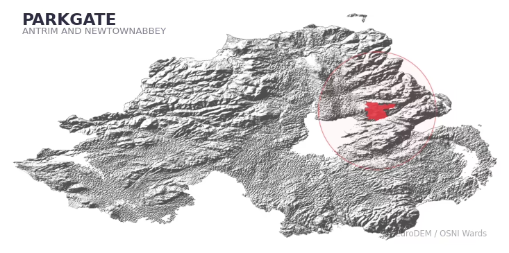
PARKGATE covers 232.5 km² in Northern Ireland. With 154 historic sites and 19 scheduled monuments on record, the ward sits at the 93rd percentile across all 462 NI wards for combined archaeological heritage. It also records 32 listed buildings (HED Historic Buildings Record), the 63rd percentile for listed-building density across NI wards. Per 1,000 residents, this works out at 62.9 recorded sites — the 95th percentile across NI wards (a measure of heritage density relative to current population). Dated archaeological evidence runs from the Mesolithic through to the Modern period, spanning 9 archaeological periods, placing the ward in the 98th percentile NI-wide for chronological depth.
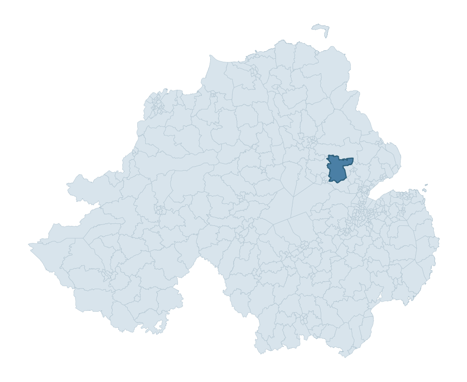
PARKGATE boundary detailPARKGATE in regional context
Heritage at a glance
Percentile rankings throughout this profile compare each ward only against the other 461 Northern Ireland wards.
154
Historic sites
96th percentile
19
Scheduled monuments
95th percentile
32
Listed buildings
63rd percentile
0.88
Sites per km²
Population context
14
Persons per km²
11th percentile
62.9
Sites per 1,000 residents
95th percentile
3,259
Total residents (2021)
The recorded heritage of PARKGATE
Of the 154 historic sites recorded, the most common are Souterrain (22, 14% of historic sites), Rath (8), and Megalithic Tomb (7). For Souterrains, this is the 93rd percentile across NI wards that record this type. For Raths, this is the 58th percentile among NI wards that record this type. Across the ward's 232.5 km², this gives a recorded density of 0.88 sites per km² (all heritage types combined). Scheduled monuments are distributed across approximately 0.07° of latitude and 0.13° of longitude within the ward, indicating dispersed rather than clustered placement.
Most common monument types
Type
Count
Description
Souterrain
22
—
Rath
8
—
Megalithic Tomb
7
—
Chronological distribution
Mesolithic
33
Neolithic
2
Early Bronze Age
10
Middle Late Bronze Age
2
Iron Age
18
Early Medieval
56
Medieval
6
Post Medieval
4
Modern
2
Unknown
21
Terrain and environment
With a mean elevation of 159m, this ward sits above the NI median (89th percentile), with a maximum of 326m giving the ward meaningful vertical relief. Mean slope is 4.4° (55th percentile across NI), giving moderately undulating terrain. The Topographic Wetness Index of 10.2 (39th NI percentile) indicates moderate drainage, balanced between upland shedding and lowland accumulation. The land cover is dominated by improved grassland (83%) and woodland (12%). In overall character, this is elevated but relatively gentle terrain — typical of plateau country, with land use dominated by improved grassland.
Terrain measurements
Mean elevation159.4 m 89th pct
Max elevation325.8 m 85th pct
Mean slope4.4° 55th pct
Wetness index (TWI)10.23 40th pct
Grassland82.6% 86th pct
Woodland12.5% 31st pct
Cropland3.6% 73rd pct
Urban land1.2% 11th pct
Where this ward sits in NI
Elevation
89th
Slope
55th
Drainage
40th
Grassland
86th
Woodland
31st
Geology and preservation
The dominant bedrock formed during the Cainozoic era (Palaeogene period). Relatively young rock formed in the last 66 million years. In Ulster, Cainozoic basalt — the lava that created the Antrim Plateau and Giant's Causeway — dominates much of the eastern landscape. Peat covers 8% of the ward — a minor share, but where it occurs it can preserve organic finds in good condition. Bedrock composition is varied (complexity index 0.85, on a 0-1 Simpson-style scale), with multiple geological units within the ward boundary. Geologically diverse wards historically offered a wider range of stone types for building, toolmaking, and quarrying — a relevant factor when interpreting the material culture of nearby sites.
Bedrock eraCainozoic
Bedrock periodPalaeogene
Surface depositsTill
Peat coverage7.5%
Bedrock complexity0.85
Placename evidence
The combined OSNI, Logainm NI, and GeoNames sources record 45 placenames for this ward. Diagnostic heritage strata identified within these are: 3 pre-Christian defensive (rath-, dún-, lios-, caiseal-) and 1 ecclesiastical (cill-, teampall-, mainistir-, díseart-). Note: Irish-language (name_ga) forms are recorded for roughly half of NI placenames in the combined sources, so anglicised forms whose Irish original could belong to multiple categories may be misclassified.
Scheduled monuments are sites legally protected under the Historic Monuments and Archaeological Objects (Northern Ireland) Order 1995, designated by the Historic Environment Division (HED).
Monument
Type
Period
Motte
Motte
Medieval
Souterrain
Souterrain
Iron Age
Motte
Motte
Medieval
Rath
Rath
Early Medieval
Standing stone
Standing Stone
Early Bronze Age
Holed Stone: the Hole Stone
Holed Stone: The Hole Stone
Unknown
Motte: Dunamoy Motte
Motte: Dunamoy Motte
Medieval
Rath
Rath
Early Medieval
Bivallate rath
Bivallate Rath
Iron Age
Neolithic hilltop enclosure and occupation site: Donegore Hill
Neolithic Hilltop Enclosure And Occupation Site: Donegore Hill
Neolithic
Mound
Mound
Unknown
Stone circle or megalithic tomb ' The Craigs'
Stone Circle Or Megalithic Tomb ' The Craigs'
Neolithic
Court Tomb: Giant's Grave
Court Tomb: Giant'S Grave
Neolithic
Court Tomb
Court Tomb
Neolithic
Standing Stone: 'The Tardree stone'
Standing Stone: 'The Tardree Stone'
Early Bronze Age
Barrow
Barrow
Early Bronze Age
Rectangular earthwork
Rectangular Earthwork
Unknown
BARROW
Barrow
Early Bronze Age
Ballywee. Complex Early Christian settlement with 4 houses & 3 Souterrains
Ballywee. Complex Early Christian Settlement With 4 Houses & 3 Souterrains
Iron Age
Recorded historic sites
Name
Period
Type
A.P. SITE – circular cropmark
Unknown
Unknown
A.P. SITE – circular cropmark
Unknown
Unknown
A.P. SITE – circular cropmark
Unknown
Unknown
A.P. SITE – circular cropmark
Unknown
Unknown
A.P. SITE – circular cropmark – Barrow
Early Bronze Age
Ritual/Funerary
A.P. SITE – circular cropmarks
Early Bronze Age
Unknown
A.P. SITE – circular enclosure
Iron Age
Unknown
A.P. SITE – circular enclosure
Iron Age
Unknown
A.P. SITE – cropmark
Unknown
Unknown
A.P. SITE – oval cropmark
Unknown
Unknown
A.P. SITE – rectangular cropmark
Unknown
Unknown
A.P. SITE – small circular cropmark – Barrow?
Early Bronze Age
Ritual/Funerary
AP Cropmark – Possible henge/large enclosure?
Neolithic
Ritual/Funerary
BARROW
Mesolithic
Ritual/Funerary
BARROW
Mesolithic
Ritual/Funerary
BATTLE SITE; 680 AD: BATTLE of RATHMOR-MAIGHE-LINE (unlocated)
Early Medieval
Defence
BATTLE SITE; 913 AD
Early Medieval
Unknown
BIVALLATE RATH & SOUTERRAIN
Early Medieval
Defence
Barrow cemetery associated with Donegore Hill 'ritual landscape'
Mesolithic
Ritual/Funerary
Barrow cemetery associated with Donegore Hill 'ritual landscape'
Mesolithic
Ritual/Funerary
Barrow cemetery associated with Donegore Hill 'ritual landscape'
Mesolithic
Ritual/Funerary
Barrow cemetery associated with Donegore Hill 'ritual landscape'
Mesolithic
Ritual/Funerary
CAIRN
Early Bronze Age
Ritual/Funerary
CAIRN
Early Bronze Age
Ritual/Funerary
CAIRN
Mesolithic
Ritual/Funerary
CAIRN with URN BURIALS: LOUGHANMORE (unlocated)
Mesolithic
Ritual/Funerary
CAIRN?
Mesolithic
Ritual/Funerary
CAIRN?: CARNLEA
Early Bronze Age
Ritual/Funerary
CHURCH & GRAVEYARD: KIRKLAND; MAUDONE (unlocated)
Unknown
Ritual/Funerary
CHURCH (site of): MAUDONE
Medieval
Religious
CHURCH SITE: BALLYMOYDEN or BALLYMAUDEN or MAUDONE (unlocated)
Medieval
Religious
CIRCULAR ENCLOSURE
Iron Age
Unknown
CIRCULAR ENCLOSURE
Iron Age
Unknown
CIRCULAR ENCLOSURE. Part of settlement complex.
Iron Age
Domestic
CIRCULAR ENCLOSURE. Part of settlement complex.
Iron Age
Domestic
COMPLEX EARLY CHRISTIAN SETTLEMENT WITH 4 HOUSES & 3 SOUTERRAINS: BALLYWEE
Early Medieval
Defence
COUNTERSCARP RATH
Early Medieval
Defence
COURT TOMB
Mesolithic
Ritual/Funerary
COURT TOMB: GIANT'S GRAVE
Mesolithic
Ritual/Funerary
CURVILINEAR ENCLOSURE
Iron Age
Unknown
ENCLOSURE
Iron Age
Unknown
ENCLOSURE
Iron Age
Unknown
ENCLOSURE
Iron Age
Unknown
ENCLOSURE
Iron Age
Unknown
ENCLOSURE
Iron Age
Unknown
ENCLOSURE?
Iron Age
Unknown
ENCLOSURE?: THE TRENCH (O.S. memoir site, unlocated)
Iron Age
Unknown
Elliptical hut platforms: part of larger area of settlement evidence.
Unknown
Domestic
FIELD SYSTEM
Middle-Late Bronze Age
Agriculture
FIELD SYSTEM
Middle-Late Bronze Age
Agriculture
FINDSPOT of 3 ROTARY QUERNS & 1 BEEHIVE QUERN
Unknown
Unknown
FINDSPOT of COINS
Unknown
Unknown
FORTIFIED HOUSE: CASTLE HILL
Unknown
Defence
HOLED STONE: THE HOLESTONE or THE DOAGH STONE
Mesolithic
Unknown
HOUSE? Part of settlement complex.
Unknown
Domestic
HUTS?
Unknown
Unknown
Historic Settlement
Post-Medieval
Domestic
LARGE ENCLOSURE
Iron Age
Unknown
LiDAR Site: Possible barrow cemetery
Early Bronze Age
Ritual/Funerary
LiDAR Site: Possible barrow cemetery
Early Bronze Age
Ritual/Funerary
LiDAR site- Possible rath/ circular enclosure
Iron Age
Defence
MASS SITE?: THE PRIEST'S CHAIR, PRIEST'S CRAIG
Post-Medieval
Unknown
MEGALITHIC TOMB
Mesolithic
Ritual/Funerary
MEGALITHIC TOMB
Neolithic
Ritual/Funerary
MEGALITHIC TOMB
Mesolithic
Ritual/Funerary
MEGALITHIC TOMB
Mesolithic
Ritual/Funerary
MEGALITHIC TOMB
Mesolithic
Ritual/Funerary
MEGALITHIC TOMB
Mesolithic
Ritual/Funerary
MEGALITHIC TOMB
Mesolithic
Ritual/Funerary
MEGALITHIC TOMB (O.S. memoir site, unlocated)
Mesolithic
Ritual/Funerary
MEGALITHIC TOMB: THE CRAIG'S or STONE CIRCLE
Mesolithic
Ritual/Funerary
MOTTE (or Raised Rath?)
Early Medieval
Defence
MOTTE: DONEGORE MOAT OR MOTTE
Medieval
Defence
MOTTE: DUNAMOY MOAT
Medieval
Defence
MOUND
Unknown
Unknown
MOUND
Unknown
Unknown
MOUND – ?BARROW
Mesolithic
Ritual/Funerary
MOUND – CAIRN?
Early Bronze Age
Ritual/Funerary
MOUND – MOTTE?
Medieval
Defence
MOUND – MOTTE?
Medieval
Defence
MOUND – RAISED RATH?
Early Medieval
Defence
MULTIPERIOD CHURCH & GRAVEYARD: DONEGORE CHURCH, DUNCURRI
Early Medieval
Ritual/Funerary
NATURAL MOUND
Unknown
Unknown
NATURAL MOUND
Unknown
Unknown
NEOLITHIC HILLTOP CAUSEWAYED ENCLOSURE & OCCUPATION SITE: DONEGORE HILL
Mesolithic
Transport
NON-ANTIQUITY – modern enclosure
Modern
Unknown
PLATFORM RATH
Early Medieval
Defence
PLATFORM RATH
Early Medieval
Defence
PLATFORM RATH
Early Medieval
Defence
PLATFORM RATH
Early Medieval
Defence
Parkgate Historic Settlement
Post-Medieval
Domestic
QUARRY
Modern
Industrial
RAISED RATH
Early Medieval
Defence
RATH
Early Medieval
Defence
RATH
Early Medieval
Defence
RATH
Early Medieval
Defence
RATH
Early Medieval
Defence
RATH
Early Medieval
Defence
RATH
Early Medieval
Defence
RATH
Early Medieval
Defence
RATH
Early Medieval
Defence
RATH & SOUTERRAIN
Early Medieval
Defence
RATH & SOUTERRAIN
Early Medieval
Defence
RATH & SOUTERRAIN: BALLYGOWAN FORT
Early Medieval
Defence
RATH (unlocated)
Early Medieval
Defence
RATH (unlocated)
Early Medieval
Defence
RATH (unlocated)
Early Medieval
Defence
RATH?
Early Medieval
Defence
RECTANGULAR EARTHWORK
Unknown
Defence
RECTANGULAR EARTHWORK: BALLYNOE FORT
Early Medieval
Defence
RECTANGULAR ENCLOSURE
Iron Age
Unknown
RING DITCH – RING BARROW?
Mesolithic
Ritual/Funerary
ROCKING STONE
Unknown
Unknown
ROUND CAIRN
Early Bronze Age
Ritual/Funerary
SOUTERRAIN
Early Medieval
Defence
SOUTERRAIN
Early Medieval
Defence
SOUTERRAIN
Early Medieval
Defence
SOUTERRAIN
Early Medieval
Defence
SOUTERRAIN
Early Medieval
Defence
SOUTERRAIN
Early Medieval
Defence
SOUTERRAIN
Early Medieval
Defence
SOUTERRAIN
Early Medieval
Defence
SOUTERRAIN
Early Medieval
Defence
SOUTERRAIN
Early Medieval
Defence
SOUTERRAIN
Early Medieval
Defence
SOUTERRAIN
Early Medieval
Defence
SOUTERRAIN
Early Medieval
Defence
SOUTERRAIN
Early Medieval
Defence
SOUTERRAIN
Early Medieval
Defence
SOUTERRAIN
Early Medieval
Defence
SOUTERRAIN
Early Medieval
Defence
SOUTERRAIN
Early Medieval
Defence
SOUTERRAIN
Early Medieval
Defence
SOUTERRAIN
Early Medieval
Defence
SOUTERRAIN
Early Medieval
Defence
SOUTERRAIN
Early Medieval
Defence
SOUTERRAIN (unlocated)
Early Medieval
Defence
SOUTERRAIN (unlocated)
Early Medieval
Defence
SOUTERRAIN (unlocated)
Early Medieval
Defence
SOUTERRAIN(S)?
Early Medieval
Defence
SOUTERRAIN: PIPER'S NEUK
Early Medieval
Defence
SQUARE ENCLOSURE (O.S. memoir site, unlocated)
Iron Age
Unknown
SQUARE ENCLOSURES
Unknown
Unknown
STANDING STONE
Mesolithic
Ritual/Funerary
STANDING STONE
Mesolithic
Ritual/Funerary
STANDING STONE
Mesolithic
Ritual/Funerary
STANDING STONE
Mesolithic
Ritual/Funerary
STANDING STONE
Mesolithic
Ritual/Funerary
STANDING STONE
Mesolithic
Ritual/Funerary
STANDING STONE: TARDREE STONE
Mesolithic
Ritual/Funerary
TREE RING
Post-Medieval
Unknown
TWO STANDING STONES
Mesolithic
Ritual/Funerary
URN BURIAL (unlocated)
Mesolithic
Ritual/Funerary
URN BURIAL (unlocated)
Mesolithic
Ritual/Funerary
Listed buildings in PARKGATE
Address / Name
Grade
Period
Outbuildings at Loughanmore
51 Loughanmore Road
Dunadry
Antrim
Co Antrim
BT41 2HN
B1
1860 – 1879
Main Gate Lodge and Gates to Loughanmore
53 Loughanmore Road
Dunadry
Antrim
Co Antrim
BT41 2HN
B2
1920 – 1939
Original Gateway to Holestone House
Ballymena Road
Doagh
Co Antrim
Grounding History: 10 Maps of Northern Ireland’s Past
A spatial history report bringing together analysis of all 462 wards into one place through 10 high-quality maps — covering monument density, archaeological periods, placename heritage, terrain, wetland, and the historic landscape at first survey.
A ward is the smallest electoral and statistical geography used by the Northern Ireland Statistics and Research Agency (NISRA). The boundaries used here are the 2014 NISRA / OSNI Wards (462 across Northern Ireland), each typically covering 1-700 km² and a population of a few thousand. Wards do not align with parishes, townlands, or any historic administrative unit — they are a modern statistical convenience, used here only as a fixed spatial frame within which to summarise heritage records.
What counts as a site?
Three distinct heritage record types are reported separately, not combined: (1) Historic Sites — entries in the Northern Ireland Sites and Monuments Record (NISMR), the inventory of recorded archaeological sites and findspots, dated from prehistoric to early-modern; (2) Scheduled Monuments — sites legally protected under the Historic Monuments and Archaeological Objects (NI) Order 1995 and maintained by the Historic Environment Division (HED); (3) Listed Buildings — buildings of architectural or historic interest protected under the Planning Act (NI) 2011 and graded A, B+, B1, B2, or Record-Only by HED. A site appearing in more than one register is counted in each register independently.
Editorial principles
These ward profiles describe evidence, not history. They report what is recorded, not what occurred. Where the data is ambiguous, we say so. We do not infer historical processes — population movements, settlement expansion, periods of decline — from patterns in the record. Absence of evidence is not evidence of absence: in Northern Ireland, where antiquarian survey was uneven and modern excavation is geographically biased, a gap in the record almost always reflects the limits of recording rather than a genuine historical absence. We mark such gaps explicitly where they appear in the data.
Limits of coverage and known caveats
Several caveats apply to every ward profile: (1) NISMR coverage is uneven across NI — some areas (notably parts of the south-east and the Belfast urban fringe) have been more intensively surveyed than others, so a low recorded site count does not reliably indicate a low past density of activity; (2) period attributions in NISMR are often 'Unknown', and chronological breakdowns reported here reflect only the dated subset; (3) placename classification depends on the Irish-language form (name_ga), which is recorded for approximately 50% of NI placenames in the combined sources, so ecclesiastical and pre-Christian counts may be understated where anglicised forms remain unparsed; (4) terrain percentile ranks compare each ward only to the other 461 NI wards; they are not absolute thresholds. For absence-dominant land cover categories (wetland, water, cropland), percentile ranks are suppressed below 1% raw value, since the ranking of zero-value wards is not meaningful.
Data sources (11)
Northern Ireland Sites and Monuments Record (NISMR)
Spotted an error? This dataset is updated continuously.
Email contact@danielkirkpatrick.co.uk with corrections, missing records, or suggestions for improvement.
Manage Consent
To provide the best experiences, we use technologies like cookies to store and/or access device information. Consenting to these technologies will allow us to process data such as browsing behaviour or unique IDs on this site. Not consenting or withdrawing consent, may adversely affect certain features and functions.
Functional
Always active
The technical storage or access is strictly necessary for the legitimate purpose of enabling the use of a specific service explicitly requested by the subscriber or user, or for the sole purpose of carrying out the transmission of a communication over an electronic communications network.
Preferences
The technical storage or access is necessary for the legitimate purpose of storing preferences that are not requested by the subscriber or user.
Statistics
The technical storage or access that is used exclusively for statistical purposes.The technical storage or access that is used exclusively for anonymous statistical purposes. Without a subpoena, voluntary compliance on the part of your Internet Service Provider, or additional records from a third party, information stored or retrieved for this purpose alone cannot usually be used to identify you.
Marketing
The technical storage or access is required to create user profiles to send advertising, or to track the user on a website or across several websites for similar marketing purposes.