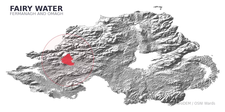
FAIRY WATER covers 328.8 km² in Northern Ireland. With 81 historic sites and 11 scheduled monuments on record, the ward sits at the 81st percentile across all 462 NI wards for combined archaeological heritage. It also records 42 listed buildings (HED Historic Buildings Record), the 72nd percentile for listed-building density across NI wards. Per 1,000 residents, this works out at 49.1 recorded sites — the 89th percentile across NI wards (a measure of heritage density relative to current population). Dated archaeological evidence runs from the Mesolithic through to the Modern period, spanning 7 archaeological periods, placing the ward in the 79th percentile NI-wide for chronological depth.
Heritage at a glance
Percentile rankings throughout this profile compare each ward only against the other 461 Northern Ireland wards.
Population context
The recorded heritage of FAIRY WATER
Of the 81 historic sites recorded, the most common are Enclosure (10, 12% of historic sites), Rath (7), and Non-Antiquity (6). For Enclosures, this is the 69th percentile among NI wards that record this type. For Raths, this is the 52nd percentile among NI wards that record this type. Across the ward's 328.8 km², this gives a recorded density of 0.41 sites per km² (all heritage types combined). Scheduled monuments are distributed across approximately 0.14° of latitude and 0.10° of longitude within the ward, indicating dispersed rather than clustered placement.
Most common monument types
| Type | Count | Description |
|---|---|---|
| Enclosure | 10 | — |
| Rath | 7 | — |
| Non-antiquity | 6 | — |
Chronological distribution
Note: 20% of historic site records carry an ‘Unknown’ period attribution. The chronological breakdown above reflects only the dated subset.
Terrain and environment
With a mean elevation of 120m, this ward sits above the NI median (80th percentile), but the ward reaches 418m at its highest point — a vertical span of more than 297m within its boundary, indicating significant topographic diversity. Mean slope is 5.1° (72th percentile across NI), giving moderately undulating terrain. The Topographic Wetness Index of 9.9 (24th NI percentile) indicates moderate drainage, balanced between upland shedding and lowland accumulation. The land cover is dominated by improved grassland (86%) and woodland (12%). In overall character, this is elevated but relatively gentle terrain — typical of plateau country, with land use dominated by improved grassland.
Terrain measurements
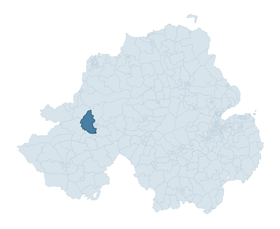
Where this ward sits in NI
Geology and preservation
The dominant bedrock formed during the Palaeozoic era (Carboniferous period). Ancient sedimentary or metamorphic rock dating to before the age of dinosaurs; the resulting landscape has been long-stable enough to host every period of human activity. Peat covers 20% of the ward. Peat-bound ground preserves organic archaeological material that would not survive on aerated mineral soils. Bedrock composition is moderately varied (complexity index 0.64), with two or three geological units present within the ward boundary.
Placename evidence
The combined OSNI, Logainm NI, and GeoNames sources record 92 placenames for this ward. Diagnostic heritage strata identified within these are: 7 pre-Christian defensive (rath-, dún-, lios-, caiseal-) and 3 ecclesiastical (cill-, teampall-, mainistir-, díseart-). Note: Irish-language (name_ga) forms are recorded for roughly half of NI placenames in the combined sources, so anglicised forms whose Irish original could belong to multiple categories may be misclassified.
Placename categories
Scheduled monuments in FAIRY WATER
Scheduled monuments are sites legally protected under the Historic Monuments and Archaeological Objects (Northern Ireland) Order 1995, designated by the Historic Environment Division (HED).
| Monument | Type | Period |
|---|---|---|
| Counterscarp rath | Counterscarp Rath | Early Medieval |
| Court tomb | Court Tomb | Neolithic |
| Wedge tomb | Wedge Tomb | Neolithic |
| Rath | Rath | Early Medieval |
| Boulder with hollows: Cloghanachorite | Boulder With Hollows: Cloghanachorite | Unknown |
| Platform rath | Platform Rath | Early Medieval |
| Four stone circles and a stone alignment | Four Stone Circles And A Stone Alignment | Early Bronze Age |
| Standing stone complex | Standing Stone Complex | Early Bronze Age |
Recorded historic sites
| Name | Period | Type |
|---|---|---|
| A.P. SITE – ELLIPTICAL ENCLOSURE | Iron Age | Unknown |
| A.P. SITE – circular cropmark | Unknown | Unknown |
| A.P. SITE – circular enclosure | Iron Age | Unknown |
| A.P. SITE – cropmark | Unknown | Unknown |
| A.P. SITE – double-ditched enclosure | Iron Age | Defence |
| AP Site- Possible large oval enclosure | Iron Age | Unknown |
| BOULDER WITH HOLLOWS: CLOGHANAA or CLOGHANACHORITE | Unknown | Unknown |
| BRONZE AGE WOODEN TRACKWAY | Mesolithic | Transport |
| BULLAUN | Early Medieval | Unknown |
| CAIRN?: CARN HILL | Early Bronze Age | Ritual/Funerary |
Listed buildings in FAIRY WATER
| Address / Name | Grade | Period |
|---|---|---|
| Clanabogan Church Dromore Road Clanabogan Lower Omagh Co Tyrone BT78 1SN | B+ | 1860 – 1879 |
| Ashfield Laurel Road Omagh Co Tyrone BT78 5DH | B1 | 1840 – 1859 |
| Dudgeon Bridge Dunwish Road Omagh Co. Tyrone BT78 5PH | B2 | 1780 – 1799 |
| Bridge over Creevan Burn Botera Upper Road, Omagh Co. Tyrone BT78 5LH | B2 | 1840 – 1859 |
| Cavanacaw Bridge, Laurel Road Omagh, Co Tyrone BT78 5DH | B1 | 1840 – 1859 |
| Clanabogan House 85 Clanabogan Road Omagh Co. Tyrone BT78 1SL | B1 | 1740 – 1759 |
| St. Mary's RC Church 35 Fireagh Road Omagh Co Tyrone BT78 1SG | B1 | 1840 – 1859 |
| The Rectory 119 Clanabogan Road Omagh Co Tyrone BT78 1SN | B1 | 1860 – 1879 |
| Holy Trinity Church (C of I) Rash Road Omagh Co Tyrone BT78 5NJ | B1 | 1860 – 1879 |
| Mountjoy Presbyterian Church Castletown Road Tattraconnaghty Omagh Co.Tyrone BT78 5NX | B2 | 1860 – 1879 |
Discover more in Fermanagh and Omagh
- Trillick
- Belleek And Boa
- Irvinestown
- Beragh
- Derrylin
- Fintona
- Camowen
- Fairview — Antrim and Newtownabbey
- Fathom — Newry, Mourne and Down
- Foyle Springs — Derry City and Strabane
See all 462 wards in the Northern Ireland Heritage Tool.

Want a deeper view?
Grounding History: 10 Maps of Northern Ireland’s Past
A spatial history report bringing together analysis of all 462 wards into one place through 10 high-quality maps — covering monument density, archaeological periods, placename heritage, terrain, wetland, and the historic landscape at first survey.
About this profile
What is a ward?
A ward is the smallest electoral and statistical geography used by the Northern Ireland Statistics and Research Agency (NISRA). The boundaries used here are the 2014 NISRA / OSNI Wards (462 across Northern Ireland), each typically covering 1-700 km² and a population of a few thousand. Wards do not align with parishes, townlands, or any historic administrative unit — they are a modern statistical convenience, used here only as a fixed spatial frame within which to summarise heritage records.
What counts as a site?
Three distinct heritage record types are reported separately, not combined: (1) Historic Sites — entries in the Northern Ireland Sites and Monuments Record (NISMR), the inventory of recorded archaeological sites and findspots, dated from prehistoric to early-modern; (2) Scheduled Monuments — sites legally protected under the Historic Monuments and Archaeological Objects (NI) Order 1995 and maintained by the Historic Environment Division (HED); (3) Listed Buildings — buildings of architectural or historic interest protected under the Planning Act (NI) 2011 and graded A, B+, B1, B2, or Record-Only by HED. A site appearing in more than one register is counted in each register independently.
Editorial principles
These ward profiles describe evidence, not history. They report what is recorded, not what occurred. Where the data is ambiguous, we say so. We do not infer historical processes — population movements, settlement expansion, periods of decline — from patterns in the record. Absence of evidence is not evidence of absence: in Northern Ireland, where antiquarian survey was uneven and modern excavation is geographically biased, a gap in the record almost always reflects the limits of recording rather than a genuine historical absence. We mark such gaps explicitly where they appear in the data.
Limits of coverage and known caveats
Several caveats apply to every ward profile: (1) NISMR coverage is uneven across NI — some areas (notably parts of the south-east and the Belfast urban fringe) have been more intensively surveyed than others, so a low recorded site count does not reliably indicate a low past density of activity; (2) period attributions in NISMR are often 'Unknown', and chronological breakdowns reported here reflect only the dated subset; (3) placename classification depends on the Irish-language form (name_ga), which is recorded for approximately 50% of NI placenames in the combined sources, so ecclesiastical and pre-Christian counts may be understated where anglicised forms remain unparsed; (4) terrain percentile ranks compare each ward only to the other 461 NI wards; they are not absolute thresholds. For absence-dominant land cover categories (wetland, water, cropland), percentile ranks are suppressed below 1% raw value, since the ranking of zero-value wards is not meaningful.
Data sources (11)
- Northern Ireland Sites and Monuments Record (NISMR) https://www.communities-ni.gov.uk/articles/nismr-public-mapviewer
- HED Scheduled Monuments Dataset https://www.opendatani.gov.uk/@historic-environment-division/scheduled-monuments-northern-ireland
- HED Historic Buildings Record https://www.communities-ni.gov.uk/topics/historic-environment/listed-buildings
- OSNI OS Open Names (Northern Ireland) https://www.opendatani.gov.uk/@ordnance-survey-of-northern-ireland/osni-open-data—50k-gazetteer
- Logainm — Placenames Database of Ireland https://www.logainm.ie/
- GeoNames https://www.geonames.org/
- Census 2021 (Northern Ireland) https://www.nisra.gov.uk/statistics/2021-census
- OSNI Open Data — Largescale Boundaries https://www.opendatani.gov.uk/@ordnance-survey-of-northern-ireland/osni-open-data-largescale-boundaries-wards-2012
- Copernicus GLO-30 DEM https://spacedata.copernicus.eu/collections/copernicus-digital-elevation-model
- ESA WorldCover https://esa-worldcover.org/
- GSNI 1:250,000 Geology https://www.bgs.ac.uk/geological-data/maps/