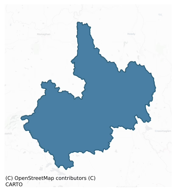
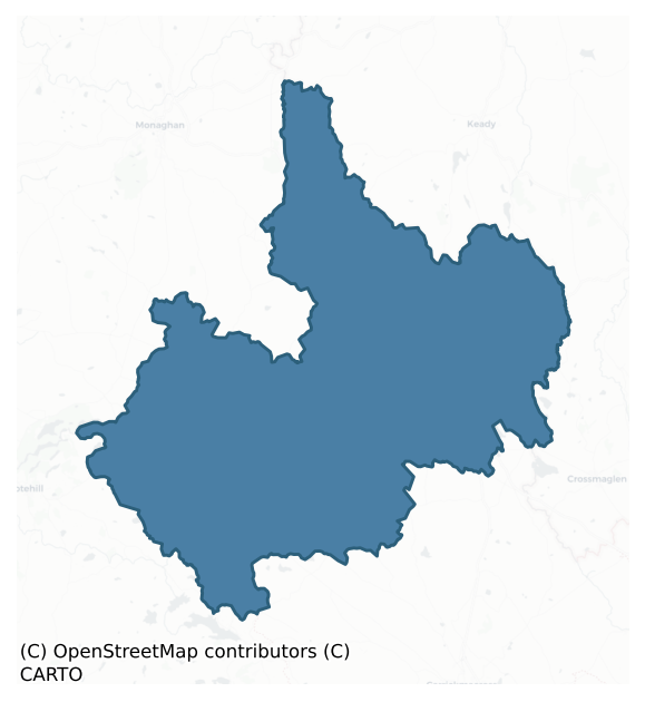
Cremorne is a barony of County Monaghan, in the historical province of Ulster (Irish: Críoch Mhúrn), covering 346 km² of land. The barony records 313 NMS archaeological sites and 278 NIAH listed buildings, placing it at around the 9th percentile among 280 ROI baronies for sites per km². This means it is in the bottom tenth of all baronies for sites per km². Dated archaeological evidence runs from the Neolithic through to the Post Medieval, spanning 7 of 9 archaeological periods, placing the barony in the 43rd percentile among 280 ROI baronies for chronological depth. This means it is in the lower half of all baronies for chronological depth. The largest dated subset of recorded sites dates to the Early Medieval. Logainm flags 53 placenames in the barony as carrying a recognised heritage root; the largest share — around 57% — are names associated with pre-christian defensive.
Heritage at a glance
Percentile rankings throughout this profile compare each barony only against the other 279 Republic of Ireland baronies.
The recorded heritage of Cremorne
The National Monuments Service Sites and Monuments Record (SMR) is the statutory inventory of archaeological sites for the Republic of Ireland, maintained by the Department of Tourism, Culture, Arts, Gaeltacht, Sport and Media. Sites recorded here include earthworks, ringforts, megalithic tombs, ecclesiastical remains, and post-medieval features; not every record is legally protected, but each is registered as a monument of archaeological interest.
The National Monuments Service records 313 archaeological sites in Cremorne, putting it at the 9th percentile among 280 ROI baronies for sites per km². This means it is in the bottom tenth of all baronies for sites per km². A sparse recorded total of this kind in Ireland often reflects survey priority rather than genuine absence of past activity. Protection coverage is near-universal — 306 sites (98%) fall within a recorded monument protection zone, indicating an extensively surveyed landscape. The dominant category is defensive sites — ringforts, enclosures, hillforts, and stone forts (230 sites, 73% of the record). Ringfort – rath is the most prevalent type, making up 55% of the barony's recorded sites (172 records) — well above the ROI average of 20% across all baronies where this type occurs. Ringfort – rath is an earthen ringfort enclosed by a bank and external ditch — the most common Early Medieval farmstead, broadly dated 500–1000 AD. Other significant types include Crannog (24) and Souterrain (18). Crannog is an artificial or partly artificial island built up on a lake or river bed, in use from the 6th to 17th centuries AD; Souterrain is an underground stone-built passage and chamber, generally Early Medieval and often associated with ringforts as a defensive or storage feature. Across the barony's 346 km², this gives a recorded density of 0.91 sites per km².
Most common monument types
Hover or tap a monument type to see its definition.
| Type | Count |
|---|---|
| Ringfort – rath an earthen ringfort enclosed by a bank and external ditch — the most common Early Medieval farmstead, broadly dated 500–1000 AD | 172 |
| Crannog an artificial or partly artificial island built up on a lake or river bed, in use from the 6th to 17th centuries AD | 24 |
| Souterrain an underground stone-built passage and chamber, generally Early Medieval and often associated with ringforts as a defensive or storage feature | 18 |
| Enclosure a banked or ditched feature of uncertain type, used as a catch-all where the original function cannot be determined from surface evidence | 8 |
| Hut site a low stone or earthen foundation enclosing a small circular or oval area, generally interpreted as a former dwelling, of any date from prehistory to the medieval period | 8 |
| Church a building used for public Christian worship, of any date from c. 500 AD onwards | 7 |
| Megalithic tomb – unclassified a megalithic tomb whose form cannot be assigned to court, portal, passage, or wedge categories | 6 |
Chronological distribution
The dated archaeological record for Cremorne spans from the Neolithic through to the Post Medieval, with activity attested across 7 of 9 archaeological periods. Every period from earliest to latest is represented in the record — an unbroken sequence of dated activity across the full chronological span. Activity concentrates most heavily in the Early Medieval (180 sites, 63% of dated material), with the Iron Age forming a secondary peak (69 sites, 24%). A further 26 recorded sites (8% of the overall NMS register for the barony) carry no period attribution — appearing as 'Unknown' in the bar chart below. This typically reflects either records that pre-date the standardised period vocabulary or sites awaiting specialist dating review, rather than a genuine absence of chronological evidence.
Sample of recorded monuments
Show 25 sample monuments (of 313 total)
A representative sample of 25 recorded monuments drawn from the barony’s 313 total NMS entries. Sites within a recorded monument protection zone and rarer site types are prioritised so the list shows a meaningful cross-section rather than only the most common type. Each entry shows the official Sites and Monuments Record reference number and the description published by the National Monuments Service.
Ceremonial enclosure
Located on a small hill at the NE end of a small NE-SW ridge, with a NE-SW section of a small stream c. 160m to the SE and a S-N section of the Cor River c. 370m to the W. The internal barrow is depicted as a small…
Located on a small hill at the NE end of a small NE-SW ridge, with a NE-SW section of a small stream c. 160m to the SE and a S-N section of the Cor River c. 370m to the W. The internal barrow is depicted as a small embanked feature (ext. diam. c. 20m) described as a ‘Moat’ in gothic lettering on the 1834 edition of the OS 6-inch map, and the enclosure as a hachured feature (diam. c. 50-55m) with an inner hachured feature on the 1907 edition.
This is a domed subcircular and grass-covered area (dims 55m N-S; 48m E-W) defined by an earthen bank (at SE: Wth c. 3m; int. H 0.3m; ext. H 1.8m) and hedge, and an outer fosse (Wth of base c. 1m; D 0.1-0.2m) visible W-N and but absent elsewhere. The surviving bank is generally lower than the top of the hill. There is a bowl-barrow (MO010-015001-) just NW of the centre. There are several entrances but that at SW might be original. The enclosure was overgrown in 1983 but the scrub had been cleared by 1995 (OSAP).
Date of revised upload: 26 January 2018
Compiled by: Michael Moore
Megalithic tomb – passage tomb
Located in a small clearing on top of and around the middle of the N-S ridge of Mullyash Mountain. Folklore associates it with a princess who unfortunately died in a battle between her husband and her father (IFC:…
Located in a small clearing on top of and around the middle of the N-S ridge of Mullyash Mountain. Folklore associates it with a princess who unfortunately died in a battle between her husband and her father (IFC: Schools Manuscripts (942) 353-4: https://www.duchas.ie/en/cbes ), and the cairn was also a centre for Lughnasa celebrations (MacNeill 1962, 161-3). This is a circular cairn (diam. of base 16m; H c. 2.5m) with a kerb of battered drystone walling (at N: H 2m) NNW-E-S but the edge of the original cairn is obscured by collapse elsewhere, and cairn material has spilled over the wall all around. Immediately W of the centre is a modern depression (diam. 3m; D 0.5m). A second inner tier of drystone kerbing is intermittently visible on the summit and there might be an entrance obscured in the cairn at W (Desmond 2000). According to Shirley (1879, 513) 'a cairn was opened … in 1816 and human bones and an earthen bowl were found' at Knocknaneen. As no known cairn exists now in Knocknaneen townland, which is the townland immediately to the N, this may refer to the Mullyash/Tavanaskea cairn. A standing stone (MO020-029—-) c. 850m to the SSW in Tavanskea townland was associated with it in the Lughnasa celebrations, but the stone is now lying prone in forestry.
This is a National Monument in state guardianship (NO. 564) accessed by forestry roads, and it is on the Monaghan Way, a sign-posted walking route, for which see this web-page accessed on 13/02/2018: http://blackwat…
Megalithic tomb – portal tomb
Situated on a SW-facing slope c. 100m S of a small col between slight rises to the E and W. From a survey by H. G. Tempest made in 1936 (SMR file) it appears to be a cairn (L 28m; Wth 12m) aligned NNE-SSW incorporating…
Situated on a SW-facing slope c. 100m S of a small col between slight rises to the E and W. From a survey by H. G. Tempest made in 1936 (SMR file) it appears to be a cairn (L 28m; Wth 12m) aligned NNE-SSW incorporating a portal-tomb opening to the NNE at the N end. The tomb (L 2m; Wth 1.1m) is represented by pair of portal stones, two side stones, a back stone and a displaced roof stone. The remains of two subsidiary chambers open off the cairn on the E side. It may have been removed since 1984.
The above description is derived from the published 'Archaeological Inventory of County Monaghan' (Dublin: Stationery Office, 1986). In certain instances the entries have been revised and updated in the light of recent research.
Revised by: Michael Moore
Date of revision: 22 June 2018
House – fortified house
Located on a shelf towards the bottom of a NE-facing slope which overlooks White Island and the N end of Muckno Lough. Sir Edward Blayney was a captain in the English garrison at Monaghan town (MO009-060—-) from 1602.…
Located on a shelf towards the bottom of a NE-facing slope which overlooks White Island and the N end of Muckno Lough. Sir Edward Blayney was a captain in the English garrison at Monaghan town (MO009-060—-) from 1602. He was instrumental in establishing its defences and in the building of a fortified house (MO009-060003-) there, for which he received a grant of former church land in Monaghan barony. In 1607 he received a grant of land at Ballylurgan, also known as Ballifort, which consisted of two ballybetaghs (or villages, each of sixteen tates or townlands) in Cremorne barony on condition that he built a fort there within four years (Lavery 1907, 31-2). The location was half-way between Monaghan town and Newry, and the castle would provide a secure halting-place in re-supplying the former from the latter (Livingstone 1966, 141-2). In 1612 Sir Edward received a further grant of the Muckno church lands, which included the ballybetaghs of Ballinknockluske (Coyle 1980), with the result that he could have held seven of the twenty two ballybetaghs in Cremorne barony. In 1621 Sir Edward was elevated to the peerage as the first Lord Blayney.
A contemporary description describes the house as: 'Sr. Edward Blanye hath buylte a very large bawn w'th lyme and stone 18 foote high, well flanked w'th bulworkes upon his land of Ballinelungan… Upon the bawne is buylte a fayre gate house and two other houses of lyme and stone upon two of the corners of the bawn w'ch flankes the whole wor…
Habitation site
The following description is derived from the published 'Archaeological Inventory of County Monaghan' (Dublin: Stationery Office, 1986). In certain instances the entries have been revised and updated in the light of…
The following description is derived from the published 'Archaeological Inventory of County Monaghan' (Dublin: Stationery Office, 1986). In certain instances the entries have been revised and updated in the light of recent research.
Date of upload/revision: 17 July 2007
Stones, stakes, pottery and many ancient remains were found when north island was ploughed in nineteenth century (JRSAI 8, 229; Wood-Martin 1886, 135; ITA Survey 1940). No visible trace now.
Well
Situated on a gentle SE-facing slope of a peninsula on the NE side of Lough Egish. When the Franciscans finally left their friary in Monaghan town (MO009-060002-) c. 1690 they probably maintained a presence in the…
Situated on a gentle SE-facing slope of a peninsula on the NE side of Lough Egish. When the Franciscans finally left their friary in Monaghan town (MO009-060002-) c. 1690 they probably maintained a presence in the county, although evidence of them is elusive. A report on the state of Popery in 1731 states categorically there were no Franciscans in Monaghan, although they were represented at Chapters of the Order held in Dublin in 1717 and 1729 (McKenna 1922, vol. 1, 13-14). In 1775 a bequest was made to the Franciscans of Lough Egish, and a farmhouse at Lattonfasky was called the Friars Garden while the well was known as the Brothers’ Well (ibid. 1, 369. McKenna (ibid. 1, 356) further records that ‘within living memory’ the eccentric ex-friar named Martin, disowned by his Order and the Bishop, led a congregation at Lattonfasky, so a Franciscan presence was maintained at Lough Egish into the late nineteenth century.
The well is depicted only on the 1907 edition of the OS 6-inch map where it is described in gothic lettering as ‘Tober na Braher’ – the brothers’ well. The field in which it is situated is attached to a small farmstead that is the only dwelling on the peninsula depicted on the 1834 edition of the OS 6-inch map and was probably occupied by friars in the eighteenth century. The well is an oval structure (dims 1.5m x 0.9m) defined by a masonry wall (H 1.3m) and roofed with four lintels. There is an opening (Wth 0.5m) at W, but it is not a holy well.
Com…
Barrow – ring-barrow
Situated on a broad SE-NW ridge or spur in a low-lying landscape with a small E-W stream curving around the point on the N side and turning S into a mill-pond. This is a circular grass-covered area (diam. 4.3m) defined…
Situated on a broad SE-NW ridge or spur in a low-lying landscape with a small E-W stream curving around the point on the N side and turning S into a mill-pond. This is a circular grass-covered area (diam. 4.3m) defined by a rounded fosse (Wth of top 4.2-4.5m; int. D 0.5-0.6m; ext. D 0.9-1m) and an outer bank (Wth of base 4.5-5.6m; ext. H 0.4-0.7m) with bushes (max. ext. diam. 18.6m NW-SE). There is a causeway (Wth of top 1.2m; H 0.6m) and entrance (Wth 2.6m) through the bank at WNW marked by stones.
The above description is derived from the published 'Archaeological Inventory of County Monaghan' (Dublin: Stationery Office, 1986). In certain instances the entries have been revised and updated in the light of recent research.
Revised by: Michael Moore
Date of revision: 30 January 2018
House – 17th century
Located on a low W-E peninsula at a point where three sections of Bawn Lough meet. Although there is a local tradition that this was the site of an abbey and school destroyed in Cromwellian times (Leslie 1929, 289; IFC…
Located on a low W-E peninsula at a point where three sections of Bawn Lough meet. Although there is a local tradition that this was the site of an abbey and school destroyed in Cromwellian times (Leslie 1929, 289; IFC Schools' MSS 940, 57-8, https://www.duchas.ie/en/cbes ) there is no evidence to support this. Lough Bawn, known as the ballybetagh of Ballyfermer (from fer mór – the big heath), was part of the estate of Coll Mac Brian Mac Mahon, and was forfeited after the 1641 rebellion. Around 1695 it came into the hands of Henry Tenison, who leased it to William Barton of Thomastown, Co. Louth. Barton’s daughter married Henry’s brother Richard (Shirley 1879, 254), and the Lough Bawn estate has been in the Tenison family down to the present. Lough Bawn House was built c. 500m to the W after 1815, perhaps after this structure became defunct.
The structure is in woodland and comprises a single-storey rectangular building (ext. dims 15.2m N-S; 6.3m E-W; H c. 3-5m) constructed of masonry walls with some red brick, but the N part of the structure (L 3m) does not survive above the foundations. The central portion is divided into two N-S rooms with basements below that would have had wooden ceilings but are now open. At the ground floor the E wall is lit by three surviving rectangular windows of varying dimensions (from S: Wth 1.05; 1.35m; 0.6m) but the tops of these openings do not survive, and the shorter S gable (L 5.3m) was lit by a single opening (Wth 1.15m). There are two…
Designed landscape – folly
Situated in woodland at the NW end of a NW-SE drumlin ridge, overlooking the north part of Lough Muckno. It was on the demesne of Castleblayney. It is depicted as a hollow rectangular structure with projecting angles on…
Situated in woodland at the NW end of a NW-SE drumlin ridge, overlooking the north part of Lough Muckno. It was on the demesne of Castleblayney. It is depicted as a hollow rectangular structure with projecting angles on the 1834 and 1907 editions of the OS 6-inch map where it is described in gothic lettering as a ‘Castle’ in ruins. It was described by Coote (1801, 91) as: ‘the ruins of an old building in the wood near the lake which has a curious whimsical appearance. It seems to be very ancient’, but this view is mistaken. It is also reputed to be a McMahon castle but this is unlikely (Livingstone 1966, 154).
This is a folly described by Delaney (1998, 3-4) as consisting of a stone building (dims c. 6m x c. 6m) with large circular towers (int. diam. 2.25m) centrally located in each wall (T 0.75m). There is an internal dividing wall and the original entrance and staircase were possibly located on the N side of this. The tower on the NW wall has an average H of 3m and contains two openings (Wth 0.6m; H 1.7m) with pointed brick arches. The other three towers survive to a height of c. 1m with lintel openings in NE and SE towers and possibly in the SW one although this is now destroyed. There are also lintel openings where the walls and towers join at NW and SE. (Delaney 1998, 3-4)
The above description is derived from the published 'Archaeological Inventory of County Monaghan' (Dublin: Stationery Office, 1986). In certain instances the entries have been revised and up…
Fortification
Situated at the crest of the NE-facing slope of a hill in the demesne of Castleblayney. This has never been recorded on any map. It is described (Delaney 1998, 5) as ‘an embanked area defined by a ditch (int. H 2m) on…
Situated at the crest of the NE-facing slope of a hill in the demesne of Castleblayney. This has never been recorded on any map. It is described (Delaney 1998, 5) as ‘an embanked area defined by a ditch (int. H 2m) on the NE side with a stone facing on the uphill side, creating a level area inside. It is suggested that it might have had a military function in the seventeenth century, but it is just as likely to be a folly on the Castleblayney estate like so many other features in the demesne. It is no longer extant on a golf course (OSAP).
Compiled by: Michael Moore
Date of revised upload: 27 February 2018
Barrow – mound barrow
Located on the summit of a small NW-SE ridge, it is known locally as a burial ground. This is a circular grass-covered mound (diam. of base 10.5m; diam. of top c. 7.5-8m; H 0.6-0.8m) with a slight hollow at the centre…
Located on the summit of a small NW-SE ridge, it is known locally as a burial ground. This is a circular grass-covered mound (diam. of base 10.5m; diam. of top c. 7.5-8m; H 0.6-0.8m) with a slight hollow at the centre and with stones accumulating on the perimeter N-E-S, those N-E probably forming a kerb.
Compiled by: Claire Breen
Date of uplaod: 29 February 2012
Standing stone
Situated in dense forestry towards the top of a S-facing slope on Mullyash Mountain. The stone is broken into two pieces (piece 1: L c. 2.2m; Wth 2.2m; T at N end 0.6m; piece 2: L c. 0.65m; Wth 0.85m; T 0.6m), and is…
Situated in dense forestry towards the top of a S-facing slope on Mullyash Mountain. The stone is broken into two pieces (piece 1: L c. 2.2m; Wth 2.2m; T at N end 0.6m; piece 2: L c. 0.65m; Wth 0.85m; T 0.6m), and is now recumbent with a flat face of the stone visible. The stone is tapered at both ends and modern graffiti are on the upper face. The stone had a role in the Lughnasa celebrations centred on the passage tomb (MO015-007—-), which is on the summit of the ridge c. 850m to the NNW (MacNeill 1962, 161-3). A long stone in Mullyash Plantation 'that had the footprint of a giant marked on it’ was noted in folk tradition (IFC Schools MSS: (942) 158; (943) 274), for which see this web-page accessed on 11/06/2018: https://www.duchas.ie/en/cbes Such a mark is not visible on the upper surfaces now. The folk tradition also recorded that Fionn MacCumhaill threw it the length of a field (ibid. 943, 274).
Compiled by: Claire Breen
Revised by: Michael Moore
Date of revised upload: 22 June 2017
Font
Part of the perforated octagonal shaft (dims 0.24m x 0.24m; H 0.47m) of a font from the graveyard of Mullandoy (MO020-020002-) has been acquired by Monaghan County Museum (Walsh 1983, 177). It is decorated with figures…
Part of the perforated octagonal shaft (dims 0.24m x 0.24m; H 0.47m) of a font from the graveyard of Mullandoy (MO020-020002-) has been acquired by Monaghan County Museum (Walsh 1983, 177). It is decorated with figures and is of fifteenth or sixteenth century date.
Compiled by: Michael Moore
Date of upload: 30 November 2016
Barrow – bowl-barrow
Located NW of the centre of the ceremonial enclosure (MO010-015—-). This is a circular scrub-covered and steep-sided mound (diam. of base 13m; diam. of top 2m; H 2m) defined by a fosse (Wth 2.6m; D 0.4m) SE-SW and…
Located NW of the centre of the ceremonial enclosure (MO010-015—-). This is a circular scrub-covered and steep-sided mound (diam. of base 13m; diam. of top 2m; H 2m) defined by a fosse (Wth 2.6m; D 0.4m) SE-SW and NW-NE with a causeway (Wth 2m) at W.
Compiled by: Michael Moore
Date of upload: 26 January 2018
Cupmarked stone
Situated on a SW-facing slope. A single cup mark (diam. 0.15m; D 4cm) is visible on a lintel stone of a window in the SW wall of the derelict house standing immediately adjacent to the perimeter of rath (MO027-004—-)…
Situated on a SW-facing slope. A single cup mark (diam. 0.15m; D 4cm) is visible on a lintel stone of a window in the SW wall of the derelict house standing immediately adjacent to the perimeter of rath (MO027-004—-) at NE.
Compiled by: Michael Moore
Date of upload: 30 January, 2018
Bawn
Located on a shelf towards the bottom of a NE-facing slope which overlooks White Island and the N end of Muckno Lough. Sir Edward Blayney built a fortified house (MO020-018—-) after 1612 on land he had been granted in…
Located on a shelf towards the bottom of a NE-facing slope which overlooks White Island and the N end of Muckno Lough. Sir Edward Blayney built a fortified house (MO020-018—-) after 1612 on land he had been granted in Cremonrne barony at Ballylurgan, also known as Ballifort. A contemporary description describes how he ‘hath buylte a very large bawn w'th lyme and stone 18 foote high, well flanked w'th bulworkes upon his land of Ballinelungan… Upon the bawne is buylte a fayre gate house and two other houses of lyme and stone upon two of the corners of the bawn w'ch flankes the whole work. They containe two or three roomes or lodginges a pice w'th chimneys;’ Inside the bawn he buit a ‘fayre and spacious house’ (Shirley 1879, 241; Hunter 1975 81-2). The precise location of the house and bawn is not known, but Coote (1801, 91) says the new house which was built in 1799 was contiguous to the old one.
Compiled by: Michael Moore
Date of upload: 29 June 2018
Hilltop enclosure
Situated just E of the summit of an E-W drumlin ridge. This is a large circular grass-covered area (diam. 97m E-W; 93m N-S) that is domed N-S across the ridge. It is defined by an earthen bank (at W: Wth of base 4.5m;…
Situated just E of the summit of an E-W drumlin ridge. This is a large circular grass-covered area (diam. 97m E-W; 93m N-S) that is domed N-S across the ridge. It is defined by an earthen bank (at W: Wth of base 4.5m; Wth of top 1.5m; int. H 0.6m; ext. H 2.5m) and hedge SW-NW and SE-S but it is largely reduced to a scarp and hedge, and an outer, rounded fosse (at W: Wth of top 3.5m; Wth of base 1.5m; ext. D 1.6m). There is an external field bank SW-N-ENE that replaces the fosse ENE-SSE and a farm lane runs in the fosse SSE-SW. There are many gaps in the perimeter but the original entrance might be the modernised entrance at SE.
The above description is derived from the published 'Archaeological Inventory of County Monaghan' (Dublin: Stationery Office, 1986). In certain instances the entries have been revised and updated in the light of recent research.
Revised by: Michael Moore
Date of revision: 18 June 2018
Enclosure – large enclosure
Situated on the N shore of a bay (dims c. 330m E-W; c. 100-230m N-S) that is on the N shore of White Lough. A large circular embanked enclosure (ext. diam. c. 80-85m) is depicted only on the 1834 edition of the OS…
Situated on the N shore of a bay (dims c. 330m E-W; c. 100-230m N-S) that is on the N shore of White Lough. A large circular embanked enclosure (ext. diam. c. 80-85m) is depicted only on the 1834 edition of the OS 6-inch map. Slight indications a bank survive NW-NE which morph into a field bank NE-SE while the shore forms the boundary SE-S. A house had been built in the SW quadrant by 1995 (OSAP).
The above description is derived from the published 'Archaeological Inventory of County Monaghan' (Dublin: Stationery Office, 1986). In certain instances the entries have been revised and updated in the light of recent research.
Revised by: Michael Moore
Date of revision: 19 June 2019
Kiln – lime
Situated on the SE-facing slope of a rise in an undulating landscape. It is depicted only on the 1907 edition of the OS 6-inch map where it is described in gothic lettering as a ‘Stone Circle’. This is an overgrown pit…
Situated on the SE-facing slope of a rise in an undulating landscape. It is depicted only on the 1907 edition of the OS 6-inch map where it is described in gothic lettering as a ‘Stone Circle’. This is an overgrown pit (dims of base 5.2m NE-SW; 3.2m NW-SE) cut into the hillslope and open to the SE with the slope retained by a stone-facing (max. H 1.75m).
The above description is derived from the published 'Archaeological Inventory of County Monaghan' (Dublin: Stationery Office, 1986). In certain instances the entries have been revised and updated in the light of recent research.
Revised by: Michel Moore
Date of revision: 22 June 2018
Megalithic tomb – wedge tomb
Situated on the E-facing spine of an E-W drumlin ridge. From a plan by H. G. Tempest made in 1936 (SMR file) this appears to be a wedge-tomb consisting of gallery aligned NE-SW, flanked by two buttresses and a single…
Situated on the E-facing spine of an E-W drumlin ridge. From a plan by H. G. Tempest made in 1936 (SMR file) this appears to be a wedge-tomb consisting of gallery aligned NE-SW, flanked by two buttresses and a single outer walling stone on the NW side. The gallery (L 3m; Wth 0.7m) has a short portico at SW. Two displaced roof stones lie across the gallery. The structure is incorporated in a mound (L 11m; Wth 5m). It is listed as a wedge tomb (de Valera and Ó Nualláin 1982, 131).
The above description is derived from the published 'Archaeological Inventory of County Monaghan' (Dublin: Stationery Office, 1986). In certain instances the entries have been revised and updated in the light of recent research.
Revised by: Michael Moore
Date of revision: 22 June 2018
Cairn – unclassified
Located on a terrace just below the crest of a W-facing slope. It is depicted on the 1834 edition of the OS 6-inch map where it is described in gothic lettering as a ‘Cromlech’ and it is described as ‘Labbyfirmore’ –…
Located on a terrace just below the crest of a W-facing slope. It is depicted on the 1834 edition of the OS 6-inch map where it is described in gothic lettering as a ‘Cromlech’ and it is described as ‘Labbyfirmore’ – the bed of the big men – on the 1907 edition. This is a circular grass and furze-covered cairn (diam. c. 20m) with evidence of three cists. One cist consists of a large capstone supported on two long side-stones and one end-stone. A second cist to the SW is roofed by a single large roof-stone supported by six slender upright stones. The third cist is only visible as portion of what might be a roof-stone buried I in the cairn just S of an E-W field bank that overlies the N part of the cairn.
The above description is derived from the published 'Archaeological Inventory of County Monaghan' (Dublin: Stationery Office, 1986). In certain instances the entries have been revised and updated in the light of recent research.
Revised by: Michael Moore
Date of revision: 9 May 2018
Cairn – unclassified
Located on top of a drumlin and immediately outside the fosse of rath (MO024-036—-) at SW. A grass-covered subrectangular cairn (dims 15.7m NW-SE; 9.5m NE-SW; H 0.85-1m) is truncated by the bank of rath…
Located on top of a drumlin and immediately outside the fosse of rath (MO024-036—-) at SW. A grass-covered subrectangular cairn (dims 15.7m NW-SE; 9.5m NE-SW; H 0.85-1m) is truncated by the bank of rath (MO024-036—-) at E and by a N-S field bank at W. A large cist protrudes from the cairn at N. The cist (dims 1.5m N-S; 0.5m E-W; H 0.4m) has long side-stones at E (dims 1.55m x 0.2m; H 0.4m) and W (dims 1.15m; x 0.2m; H 0.4m) and an end-stone at S but it is open at N. It is covered by a large roof-stone (dims 1.3m NE-SW; 1.2m NW-SE; T 0.45-0.5m).
The above description is derived from the published 'Archaeological Inventory of County Monaghan' (Dublin: Stationery Office, 1986). In certain instances the entries have been revised and updated in the light of recent research.
Revised by: Michael Moore
Date of revision: 9 May 2018
Hilltop enclosure
Located on top of a drumlin. A large subcircular area is described in gothic lettering as ‘Ancient Burial Ground’ on the 1834 edition of the OS 6-inch map and as a disused Grave Yard in italic lettering on the 1907…
Located on top of a drumlin. A large subcircular area is described in gothic lettering as ‘Ancient Burial Ground’ on the 1834 edition of the OS 6-inch map and as a disused Grave Yard in italic lettering on the 1907 edition. This is a large subcircular grass-covered area (dims 111m NW-SE; 91m NE-XW) defined by a scarp (at W: Wth 1.8m; H 1.8m) and hedge. A small bulbous extension at NW (diam. c. 30m) is defined by the same scarp and hedge SW-NW-ENE but it is an integral part of the larger enclosure. The interior and its extension are bisected by a NW-SE field bank and drain, and the ground slopes down steeply to the NE on the NE side of this feature but is more level to the SW. There are entrance gaps at W, NW, NNW and ENE that are probably all modern. A small enclosure (MO026-008002-) against the perimeter at SE-S is probably the burial ground rather than the whole of the large enclosure.
The above description is derived from the published 'Archaeological Inventory of County Monaghan' (Dublin: Stationery Office, 1986). In certain instances the entries have been revised and updated in the light of recent research.
Compiled by: Michael Moore
Date of revision: 26 February 2018
Enclosure – large enclosure
Located on the SE-facing spine of a NW-SE drumlin ridge. It is depicted faintly as an oval enclosure described as a ‘fort’ in gothic lettering on the 1834 edition of the OS 6-inch map and as an oval field on the 1907…
Located on the SE-facing spine of a NW-SE drumlin ridge. It is depicted faintly as an oval enclosure described as a ‘fort’ in gothic lettering on the 1834 edition of the OS 6-inch map and as an oval field on the 1907 edition. This is an oval grass-covered area (dims 65.7m NW-SE; 46.5m NE-SW) defined by a scarp (Wth 1.6-3.6m; H at W 2.3m). There is no visible fosse but there are modern gaps at SE (Wth c. 3m) and SW.
The above description is derived from the published 'Archaeological Inventory of County Monaghan' (Dublin: Stationery Office, 1986). In certain instances the entries have been revised and updated in the light of recent research.
Revised by: Michael Moore
Date of revision: 31 January 2018
Ringfort – rath
This location is marked only on a revision of the 1834 edition of the OS 6-inch map dated 1858 where it is described as ‘Site of fort’. No archaeological feature is visible on aerial images (OSAP)in an area where the…
This location is marked only on a revision of the 1834 edition of the OS 6-inch map dated 1858 where it is described as ‘Site of fort’. No archaeological feature is visible on aerial images (OSAP)in an area where the field banks have altered radically between the 1834 and 1907 editions of the OS 6-inch map.
The above description is derived from the published 'Archaeological Inventory of County Monaghan' (Dublin: Stationery Office, 1986). In certain instances the entries have been revised and updated in the light of recent research.
Date of revision: 26 January 2018
Listed buildings
The National Inventory of Architectural Heritage (NIAH) is a state survey appraising buildings of architectural, historical, archaeological, artistic, cultural, scientific, social, or technical interest. Each surveyed structure receives a rating from International (the highest, for buildings of European importance) through National, Regional, Local, and Record-Only.
The NIAH records 278 listed buildings in Cremorne, the 86th percentile across ROI baronies for listed-building density. All recorded buildings carry Regional or lower grading; the barony does not contain any structures appraised as being of National or International architectural importance. Construction dates concentrate most heavily in the Victorian (1830-1900) period. The most-recorded building type is house (69 examples, 25% of the listed stock).
Terrain and environment
Mean elevation across the barony is 133m — the 81st percentile among 280 ROI baronies for elevation. This means it is in the top fifth of all baronies for elevation. This is a relatively elevated landscape by ROI standards. Elevation matters for heritage because higher-altitude baronies typically favour defensive monuments — ringforts and hilltop forts placed on prominent ground — while lowland baronies are more likely to carry the dense settlement and church networks of intensive agricultural landscapes. A maximum elevation of 329m gives the barony meaningful vertical relief. Mean slope is 5.4° — the 77th percentile among 280 ROI baronies for slope. This means it is in the top third of all baronies for slope. This is consistently steep terrain by ROI standards, the kind of landscape that tends to preserve upstanding archaeological features well. Slope is a key control on both land use and archaeological preservation: steep ground resists ploughing and tends to preserve earthworks intact, while gentle slopes favour intensive cultivation that damages or destroys surface archaeology over time. The Topographic Wetness Index averages 9.9, the 19th percentile among 280 ROI baronies for wetness. This means it is in the bottom fifth of all baronies for wetness. This is well-drained ground by ROI standards — typical of upland or steeply-sloping country that sheds water rapidly. Drainage matters for heritage because poorly-drained ground preserves organic archaeology (wooden trackways, leather, textiles, and on rare occasions human remains) far better than free-draining soil; well-drained ground favours arable use but destroys organic material rapidly. The land cover is dominated by improved grassland (85%) and woodland (11%). In overall character, this is an upland landscape of steep, elevated terrain, with land use dominated by improved grassland.
Terrain measurements
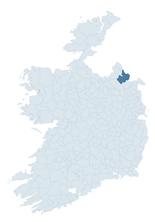
Where this barony sits in the Republic of Ireland
Geology and preservation
Bedrock geology shapes the landscape long before any settlement begins — controlling soil drainage, agricultural potential, the survival of upstanding monuments, and the preservation of buried archaeology. The figures below come from the Geological Survey Ireland 1:100,000 bedrock map.
The bedrock underlying Cremorne is predominantly sandstone (69% of the barony by area), laid down during the Silurian period (85% by area, around 444 to 419 million years ago). Sandstone weathers to free-draining, moderately fertile soils that supported Early Medieval ringfort agriculture and later manorial estates. The rock itself is a major source of building stone — visible in churches, tower houses, and farm buildings across the barony's historic landscape. The single largest mapped unit is the Lough Avaghon Formation (45% of the barony's bedrock). With 7 distinct rock types mapped, the barony sits in the top third of ROI baronies for geological diversity (75th percentile) — typically a sign of complex tectonic history or coastal mosaics of differing rock units.
Rock type composition
Largest mapped unit: Lough Avaghon Formation (45% of the barony)
Placename evidence
Logainm records 53 heritage-diagnostic placenames for Cremorne, drawn from townland and civil-parish names across the barony. The dominant stratum is pre-Christian and Early Medieval defensive — ráth-, lios-, dún-, and caiseal-prefixed names that mark Iron Age and early historic settlement. The leading diagnostic roots are lios- (20 — ringfort or enclosure), cill- (12 — church), and ráth- (5 — earthen ringfort). This is above the ROI average of 30.7 heritage placenames per barony. The presence of multiple heritage strata side by side indicates layered occupation of the landscape across successive prehistoric and historic periods. Logainm records 372 placenames for Cremorne (predominantly townland names). Of these, 53 (14%) carry one of the diagnostic Gaelic roots tracked above; the remainder draw on more generic landscape vocabulary that does not encode a heritage period.
Pre-Christian / Early Medieval Defensive
| Root | Count | Meaning |
|---|---|---|
| lios- | 20 | ringfort or enclosure |
| ráth- | 5 | earthen ringfort |
| dún- | 4 | hilltop or promontory fort |
| caiseal- | 1 | stone ringfort |
Early Christian Ecclesiastical
| Root | Count | Meaning |
|---|---|---|
| cill- | 12 | church (early) |
| bile- | 1 | sacred tree / boundary marker |
Burial, Ritual, and Norse-Contact
| Root | Count | Meaning |
|---|---|---|
| leacht- | 3 | grave monument |
| uaimh- | 3 | cave / souterrain |
| gall- | 2 | foreigner — Norse settlement marker |
| tuaim- | 1 | burial mound |
| carn- | 1 | cairn |
| feart- | 1 | grave mound |
| sián- | 1 | fairy mound |
About this profile
Click any section below to expand.
What is a barony?
A barony is a historic administrative unit in Ireland, broadly equivalent to an English hundred. The 280 baronies used here are from the OSi 2019 National Statutory Boundaries (generalised 20m), covering the 26 counties of the Republic of Ireland. Baronies derive from the Norman period, were formalised in the 17th century, and have not been redrawn for statistical purposes. They vary enormously in area, from compact urban baronies in Dublin to vast upland baronies in Connacht, and should not be compared by raw site count without accounting for area differences.
What counts as a site?
This profile combines three distinct heritage registers, each with its own definition of what constitutes a recordable site:
- Archaeological sites (NMS). The National Monuments Service Sites and Monuments Record (SMR) catalogues every known archaeological monument or site of archaeological interest in the Republic, from prehistoric burial mounds and ringforts to medieval churches and post-medieval defensive works. Inclusion does not require legal protection — only that the site has been identified, surveyed, and assessed as having archaeological value. A separate subset of these sites lies within a recorded protection zone, which gives them statutory protection under the National Monuments Acts.
- Listed buildings (NIAH). The National Inventory of Architectural Heritage records buildings of architectural, historical, archaeological, artistic, cultural, scientific, social, or technical interest. Each surveyed structure is appraised on a five-tier scale: International, National, Regional, Local, and Record-Only. The NIAH appraisal is informational rather than strictly statutory, but it underpins local-authority Record of Protected Structures (RPS) listings.
- Heritage placenames (Logainm). Logainm is the authoritative database of Irish placenames maintained by the Placenames Branch. This profile applies a heritage-diagnostic classifier to the Irish-language form of each townland name, flagging roots that signal defensive sites (ráth-, lios-, dún-, caiseal-, cathair-), ecclesiastical foundations (cill-, teampall-, domhnach-, mainistir-), prehistoric burial-ritual features (tuaim-, carn-, leaba-), or Norse-contact settlement (gall-). Townlands without one of these diagnostic roots are not flagged here — they may still carry historical significance, but that significance is not encoded in the name itself.
Editorial principles
The narrative sections of this profile follow several explicit principles:
- Evidential. Every claim about this barony’s heritage character is anchored in the underlying register data. Where a site count, a placename count, or a percentile rank is cited, it is computed from the source datasets at export time, not estimated.
- Comparative. Counts and metrics are reported alongside their percentile rank against the other 279 ROI baronies. A barony with 50 ringforts in absolute terms could be unusually high or unusually low depending on its size and regional context; percentile ranking removes that ambiguity.
- Transparent on limits. Where a register has known coverage gaps, survey biases, or data-quality issues that affect this barony’s figures, the profile flags them rather than presenting the numbers as definitive.
- No interpretation beyond what the data supports. The narrative does not speculate about historical events, social dynamics, or cultural meaning beyond what the recorded heritage and placename evidence directly attests.
Data caveats and limits
- NMS Sites and Monuments Record is the product of survey campaigns conducted at different intensities across different counties and decades. Some baronies have been surveyed more thoroughly than others, and absolute counts should be read in that light. Sites destroyed by development before survey are typically not represented; sites in heavily forested or upland terrain are sometimes under-recorded.
- NIAH coverage is broadly complete for the Republic of Ireland but the survey was conducted on a rolling county-by-county basis, and the most recent appraisal date varies. Buildings demolished or substantially altered after their original survey may still appear in the register; conversely, recent buildings of merit may not yet have been appraised.
- Logainm classification applies a deliberately conservative pattern-matching approach to the Irish-language townland forms. The classifier prioritises true positives over recall: a townland may carry a heritage signal that the classifier doesn’t recognise, particularly where the diagnostic root has been heavily anglicised or where the townland name draws on a less common term. The 60,000+ townland records and ~9,800 classified placenames give a substantial signal at barony scale, but individual townland names should be checked against Logainm directly for definitive interpretation.
- Period attribution. The chronological distribution reflects only those NMS sites that carry a recognised period attribution in the source data. Sites listed as “Unknown” period are excluded from the dated subset.
- Boundary changes. Some baronies have undergone minor boundary adjustments since their 19th-century definition; the OSi 2019 generalised boundaries used here are the current statutory definition and may differ slightly from historical maps in border areas.
- Bedrock geology is mapped at 1:100,000 scale, which means local variation within a barony — small pockets of different rock type, mineral veins, alluvium overlying bedrock — is generalised. The dominant-system and rocktype figures are area-weighted, so a barony reading “70% Carboniferous limestone” may still contain small but archaeologically important pockets of older or younger rock. Around 3% of GSI polygons do not match the lexicon and contribute no rocktype or system attribution.
Data sources
- National Monuments Service — Sites and Monuments Record (SMR) https://data.gov.ie/dataset/national-monuments-service-archaeological-survey-of-ireland
- National Inventory of Architectural Heritage (NIAH) https://data.gov.ie/dataset/national-inventory-of-architectural-heritage-niah-national-dataset
- Logainm — Placenames Database of Ireland https://www.logainm.ie/
- Ordnance Survey Ireland — National Statutory Barony Boundaries 2019 https://data-osi.opendata.arcgis.com/
- EURODEM — European Digital Elevation Model https://www.mapsforeurope.org/datasets/euro-dem
- ESA WorldCover https://esa-worldcover.org/en
- Geological Survey Ireland — 1:100,000 Bedrock Geology https://www.gsi.ie/en-ie/data-and-maps/Pages/Bedrock.aspx
Explore more: Search any of the 280 ROI baronies, browse by historical province, or read the methodology and data sources for the full Republic of Ireland Heritage Tool.