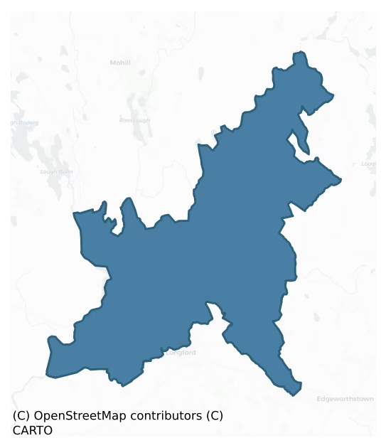
Longford is a barony of County Longford, in the historical province of Leinster (Irish: An Longfort), covering 235 km² of land. The barony records 286 NMS archaeological sites and 197 NIAH listed buildings, placing it at around the 20th percentile among 280 ROI baronies for sites per km². This means it is in the bottom third of all baronies for sites per km². Dated archaeological evidence runs from the Neolithic through to the Modern, spanning 8 of 9 archaeological periods, placing the barony in the 70th percentile among 280 ROI baronies for chronological depth. This means it is in the top third of all baronies for chronological depth. The largest dated subset of recorded sites dates to the Early Medieval. Logainm flags 31 placenames in the barony as carrying a recognised heritage root; the largest share — around 61% — are names associated with early Christian church and monastic foundations.
Heritage at a glance
Percentile rankings throughout this profile compare each barony only against the other 279 Republic of Ireland baronies.
The recorded heritage of Longford
The National Monuments Service Sites and Monuments Record (SMR) is the statutory inventory of archaeological sites for the Republic of Ireland, maintained by the Department of Tourism, Culture, Arts, Gaeltacht, Sport and Media. Sites recorded here include earthworks, ringforts, megalithic tombs, ecclesiastical remains, and post-medieval features; not every record is legally protected, but each is registered as a monument of archaeological interest.
The National Monuments Service records 286 archaeological sites in Longford, putting it at the 20th percentile among 280 ROI baronies for sites per km². This means it is in the bottom third of all baronies for sites per km². Of these, 254 (89%) fall within a recorded monument protection zone. The dominant category is defensive sites — ringforts, enclosures, hillforts, and stone forts (118 sites, 41% of the record). Ringfort – rath is the most prevalent type, making up 31% of the barony's recorded sites (89 records) — well above the ROI average of 20% across all baronies where this type occurs. Ringfort – rath is an earthen ringfort enclosed by a bank and external ditch — the most common Early Medieval farmstead, broadly dated 500–1000 AD. Other significant types include Structure – peatland (43) and Road – class 3 togher (25). Structure – peatland is a construction of unknown function, either extant or implied by archaeological evidence, of any date; Road – class 3 togher is a short wooden peatland trackway up to 15m long, deliberately laid to cross a small area of bog; Neolithic to medieval. Across the barony's 235 km², this gives a recorded density of 1.22 sites per km².
Most common monument types
Hover or tap a monument type to see its definition.
| Type | Count |
|---|---|
| Ringfort – rath an earthen ringfort enclosed by a bank and external ditch — the most common Early Medieval farmstead, broadly dated 500–1000 AD | 89 |
| Structure – peatland a construction of unknown function, either extant or implied by archaeological evidence, of any date | 43 |
| Road – class 3 togher a short wooden peatland trackway up to 15m long, deliberately laid to cross a small area of bog; Neolithic to medieval | 25 |
| Enclosure a banked or ditched feature of uncertain type, used as a catch-all where the original function cannot be determined from surface evidence | 11 |
| Graveyard a burial area associated with a church, in use from the medieval period onwards | 7 |
| Church a building used for public Christian worship, of any date from c. 500 AD onwards | 6 |
Chronological distribution
The dated archaeological record for Longford spans from the Neolithic through to the Modern, with activity attested across 8 of 9 archaeological periods. Every period from earliest to latest is represented in the record — an unbroken sequence of dated activity across the full chronological span. Activity concentrates most heavily in the Early Medieval (246 sites, 48% of dated material), with the Iron Age forming a secondary peak (155 sites, 30%). A further 482 recorded sites (49% of the overall NMS register for the barony) carry no period attribution — appearing as 'Unknown' in the bar chart below. This typically reflects either records that pre-date the standardised period vocabulary or sites awaiting specialist dating review, rather than a genuine absence of chronological evidence.
Sample of recorded monuments
Show 25 sample monuments (of 286 total)
A representative sample of 25 recorded monuments drawn from the barony’s 286 total NMS entries. Sites within a recorded monument protection zone and rarer site types are prioritised so the list shows a meaningful cross-section rather than only the most common type. Each entry shows the official Sites and Monuments Record reference number and the description published by the National Monuments Service.
Mound
A report in 1976 (SMR file) recorded a small, low, circular mound of earth and stone c. 8m to the SE of a holy well (LF002-006001-). Adjacent to it was a small, crude wooden cross (LF002-006004-). Not visible at ground…
A report in 1976 (SMR file) recorded a small, low, circular mound of earth and stone c. 8m to the SE of a holy well (LF002-006001-). Adjacent to it was a small, crude wooden cross (LF002-006004-). Not visible at ground level.
Compiled by: Patrick F. O'Donovan
Date of upload: 19 January 2012
Megalithic tomb – portal tomb
In a thicket on gently rolling farmland. This monument was almost totally demolished during land reclamation in 1982-3. The surviving portion was subsequently excavated over three seasons from 1984 to 1986 (Cooney…
In a thicket on gently rolling farmland. This monument was almost totally demolished during land reclamation in 1982-3. The surviving portion was subsequently excavated over three seasons from 1984 to 1986 (Cooney 1997). A portal-tomb chamber stood on the main axis of a long cairn at or close to its SSW end. Some 2m to the N, a subsidiary chamber opened on to the more W side of the cairn. The portal-tomb chamber (L c. 2m) consisted of two portal-stones (H 1.55m) at either end of an intervening doorstone (H 1.25m) and two inward-leaning opposed sidestones 1.2m apart. The chamber lacked a backstone. Two stones formed the S side of the subsidiary chamber (L c. 1.5m; Wth c. 1m), the more W apparently an entrance jamb (H 0.45m) overlapped by a sidestone (H 0.7m). Opposite the last, the only surviving orthostat on the N side lay almost prostrate. A small stone, apparently a packing-stone, was exposed at its W end. The E end of the chamber was closed by an inward-leaning backstone (H 0.8m). About midway between the subsidiary chamber and the portal tomb were two set stones, the taller 0.5m high. Their role was unclear. Some other large stones at the site did not appear to be structural. The excavation of the levelled site revealed traces of cairn material including a slab-built wall thought to be part of the W perimeter of the cairn revetment. Finds, mainly flakes of chert and flint, included a concave scraper and a hollow-based arrowhead. (de Valera and Ó Nualláin 1972, 87, no….
Ringfort – cashel
On a N-facing hillside. Depicted as a circular enclosure on the 1837 ed. of the OS 6-inch map. A raised oval area (35m E-W; 30m N-S) enclosed by a partially denuded low wall of drystone masonry (Wth 3-3.6m; H 0.1-1m).…
On a N-facing hillside. Depicted as a circular enclosure on the 1837 ed. of the OS 6-inch map. A raised oval area (35m E-W; 30m N-S) enclosed by a partially denuded low wall of drystone masonry (Wth 3-3.6m; H 0.1-1m). There is no trace of a fosse and the original entrance is not recognisable.
Compiled by: Patrick F. O'Donovan
Date of upload: 26 August 2011
Stone row
On top of a drumlin in pasture. A row of four, widely-spaced, upright stones, aligned NE–SW, measures 14.1m in overall length. The first stone (H 0.6m; Wth 0.27m; T 0.27m), at the NE end of the row, leans to the W.…
On top of a drumlin in pasture. A row of four, widely-spaced, upright stones, aligned NE–SW, measures 14.1m in overall length. The first stone (H 0.6m; Wth 0.27m; T 0.27m), at the NE end of the row, leans to the W. Stones piled around its base are probably field-clearance debris. The second stone (H 0.75; Wth 0.5m; T 0.3m), also leaning to the W, stands 4.25m to its SW. The third stone (H 0.66m; Wth 0.35m; T 0.3m) stands 3.7m from the previous one and its axis is transversly set to that of the row. There are some stones, again possibly field clearance, piled immediately to its W, including a stone (H 0.3m; Wth 0.5m; T 0.2m) set an angle; the function of the latter stone is unknown. The fourth stone (H 0.55m; Wth .4m; T 0.25m) stands 4.9m to the SW. The stones are known locally as the ‘Croppies’ Graves’, i.e. reputed burial places for the insurgents of the 1798 rebellion. During land reclamation extensive ground disturbance was undertaken in this area. However, the rise upon which the monument is located was not disturbed but the pathway into the field was renovated and widened; its scarped edge is immediately adjacent to the upright at the SW end of the row. There is a low scarp c. 2m to the E of the stones and running parallel to them; the function of this feature is unknown.
Compiled by: Patrick F. O'Donovan
Date of upload: 1 March 2012
Megalithic tomb – passage tomb
On the summit of Corn Hill adjacent to a tall communications mast and associated buildings. This is a large, round cairn (diam. 18m; H c. 3m) on which there is an OS trigonometrical pillar. Though largely grass- and…
On the summit of Corn Hill adjacent to a tall communications mast and associated buildings. This is a large, round cairn (diam. 18m; H c. 3m) on which there is an OS trigonometrical pillar. Though largely grass- and heather-grown, the indications are that it is of stone construction. A field wall, also the townland boundary, runs E-W across the top of the cairn. A central chamber approached by a passage from the NE, reportedly discovered in the cairn during the early decades of the 20th century, is said to have been reopened and then filled with stones in the 1960s (Herity 1974, 261). This may be a passage tomb. There are two cairns (LF005-018—- and LF005-020—-) in the vicinity: the former lies c. 120m to the SW, the latter was not located.
Compiled by: Eamon Cody
Date of upload: 27 February 2012
Cairn – unclassified
On the SW slope of Corn Hill; c. 120m to the NE, at the highest point, is a possible passage tomb (LF005-017—-). Panoramic views are afforded except from NE–E–ESE where limited by higher ground. This low, circular,…
On the SW slope of Corn Hill; c. 120m to the NE, at the highest point, is a possible passage tomb (LF005-017—-). Panoramic views are afforded except from NE–E–ESE where limited by higher ground. This low, circular, dome-shaped cairn (diam. at base 16.2m; max. H 1.2m) is divided into two unequal portions by an ENE–WSW field boundary (which also marks the boundary between the two townlands). The smaller portion, to the NNW (in Dooroc townland), has been destroyed. The cairn material is interspersed with earth and peat and a quarry-hole has been dug into the centre of the monument.
Compiled by: Patrick F. O'Donovan
Date of upload: 27 February 2012
Megalithic tomb – wedge tomb
In a copse on low-lying, wettish land adjacent to an extensive tract of bog, some 600m E of the river Shannon. Many of the structural stones of this monument are displaced. A gallery (L c. 8.5m), aligned E-W, is divided…
In a copse on low-lying, wettish land adjacent to an extensive tract of bog, some 600m E of the river Shannon. Many of the structural stones of this monument are displaced. A gallery (L c. 8.5m), aligned E-W, is divided by a septal-stone into a short portico to the W and a main chamber to the E. Two façade-stones stand forward of the N end of the septal-stone. Between these and the septal-stone is a small stone, part of the N side of the portico. Immediately W of the S end of the septal-stone is a transversely set stone. Three displaced slabs lie just E of the septal-stone, two of which are likely to be sidestones and to have stood opposite each other on either side of the gallery. Further E, three and possibly four roofstones, all dislodged to a greater or lesser extent, largely conceal what appear to be three further sidestones exposed at intervals along the S side of the gallery and two on the N side. A possible outer wall stone stands just S of the W end of the chamber. The structure stands in a mound of roughly oval outline.
Compiled by: Eamon Cody
Date of upload: 22 November 2012
See linked document with plan of monument.
Road – gravel/stone trackway – peatland
A gravel road (L 600m min.), orientated NNE-SSW, was exposed during peat-milling, c. 1980, 1m below the field surface. A section of it (L 190m; Wth 4m; D 0.2m) was excavated in 1988. It was found to be constructed of…
A gravel road (L 600m min.), orientated NNE-SSW, was exposed during peat-milling, c. 1980, 1m below the field surface. A section of it (L 190m; Wth 4m; D 0.2m) was excavated in 1988. It was found to be constructed of large pebbles set in a bed of fine gravel and sand, beneath which was a layer of coarser gravel with oak transverses that gave strength to the foundation. Beneath this again were occasional pockets of worked hazel, birch brushwood and twigs. Radiocarbon dated to AD 669-777 (1284±19 BP, GrN-16875). (Raftery 1996, Knappoge, 194-5)
Compiled by: Mary Tunney based on data supplied by the former Irish Archaeological Wetland Unit, University College, Dublin.
Date of upload: 26 August 2011
Religious house – Dominican friars
At the N edge of Longford town (LF013-026—-) within a graveyard (LF013-026002-). Established c. 1400 by the O'Farrells and dedicated to St Bridget (McNamee 1940b, 39; McNamee 1951, 8, 11-13; Gwynn and Hadcock 1970,…
At the N edge of Longford town (LF013-026—-) within a graveyard (LF013-026002-). Established c. 1400 by the O'Farrells and dedicated to St Bridget (McNamee 1940b, 39; McNamee 1951, 8, 11-13; Gwynn and Hadcock 1970, 227). Following a fire in 1429 alms were requested for the 'restoration and completion of the Friars Preachers' House of St. Bridget' (Cal. papal letters 1909, vol. 8, 94). Granted to Richard Stayne in 1566, to Nicholas Malby in 1579 (Nicholls 1994, vol. 2, 95, 492) and to Francis Annesley in 1615 (Cal. pat. rolls Ire., Jas I, 287). Depicted on an early 17th-century map of Longford barony as a small rectangular church, named 'Longford Abbey', standing near the bank of the Camlin River (BL, Cotton MS Augustus I.ii.24). In the late 17th century it was stated that 'there was a Priory of the Order of St. Dominick in this towne, now the Church said to be founded by Cornelius or Concober O'Fferrall' (Downing 1932, 21). McNamee (1954, 213) recorded that the Dominicans survived in Longford up until the mid-18th century and suggested that St John's Church (C of I) was built on the site of the priory. This church was the parish church of the 17th-century borough and while the present building appears to be modern, according to the local caretaker two walls of the priory were incorporated into it (Bradley 1985, 37). Wall foundations, probably also associated with the priory, were discovered to the N of the church when graves were being dug (ibid.). (Moore 2007, No. 26)…
Country house
Early 18th-century house, comprising two storeys over basement, constructed of well-dressed cut stone. Bence-Jones (1978, 47) recorded that there was originally a dormered attic in a high-pitched roof. The house was…
Early 18th-century house, comprising two storeys over basement, constructed of well-dressed cut stone. Bence-Jones (1978, 47) recorded that there was originally a dormered attic in a high-pitched roof. The house was partially destroyed by fire in 1922 (local information). Following this the house was reconstructed but without the upper storey. Over the modified Venetian doorway are the coat of arms of Samuel Achmuty, the original owner of the house, and a date of 1731. This house replaced an earlier house (LF013-060001-) built by Arthur Auchmuty who was of Scottish descent. He was a captain in the Cromwellian army and defended Castle Forbes during the Irish rebellion of 1641 and later died in 1698 (Burke 1847, 736).
Compiled by: Caimin O'Brien
Date of upload: 3 July 2012
Stone sculpture
On the crannog (LF002-004001-) in Clooncose Lough. According to local information, there is a tradition of a stone sculpture on a crannog. However, it was not located during a field survey of the island (pers. comm. C.…
On the crannog (LF002-004001-) in Clooncose Lough. According to local information, there is a tradition of a stone sculpture on a crannog. However, it was not located during a field survey of the island (pers. comm. C. Fredengren).
Compiled by: Paul Walsh
Date of upload: 13 June 2013
Ritual site – holy tree/bush
Associated with a holy well (LF002-006001-). A hawthorn tree, festooned with rags, is located at the N edge of a holy well.
Compiled by: Patrick F. O'Donovan
Date of upload: 7 June 2013
Cross
Within a hollow on the SSE bank of a small stream. A report in 1976 (SMR file) recorded a small, crude wooden cross and adjacent mound (LF002-006002-) c. 8m to the SE of a holy well (LF002-006004-) and a holy tree…
Within a hollow on the SSE bank of a small stream. A report in 1976 (SMR file) recorded a small, crude wooden cross and adjacent mound (LF002-006002-) c. 8m to the SE of a holy well (LF002-006004-) and a holy tree (LF002-006005-). There is no visible trace of the mound and cross.
Compiled by: Patrick F. O'Donovan
Date of upload: 26 August 2011
Anomalous stone group
On a steep NW-facing slope. A single leaning sandstone upright (H 1.2m; Wth 1.34m; T 0.4m) is aligned ENE-WSW. The stone narrows towards the top giving it a somewhat triangular profile. There are reported to have been…
On a steep NW-facing slope. A single leaning sandstone upright (H 1.2m; Wth 1.34m; T 0.4m) is aligned ENE-WSW. The stone narrows towards the top giving it a somewhat triangular profile. There are reported to have been at least three other uprights in close proximity which were destroyed in the 1950s (local information) and their position relative to the extant stone is unknown (SMR file). The nature of this monument cannot be determined on the basis of the available evidence.
Compiled by: Patrick F. O'Donovan
Date of upload: 1 March 2012
Barrow – unclassified
In wet, low-lying pasture, c. 35m to the S of a rath (LF014-082—-). A raised circular area (diam. at base 8.1m) enclosed from SE-S-W by a much-denuded, low bank of earth and stone (Wth 3.8m; H 0.1-0.25m) and defined…
In wet, low-lying pasture, c. 35m to the S of a rath (LF014-082—-). A raised circular area (diam. at base 8.1m) enclosed from SE-S-W by a much-denuded, low bank of earth and stone (Wth 3.8m; H 0.1-0.25m) and defined elsewhere by a scarp (H 0.7m). There is no trace of an encircling fosse or bank. A depression (Wth 1.45m) in the scarp at NNW may mark the original entrance.
Compiled by: Patrick F. O'Donovan
Date of upload: 26 August 2011
Castle – tower house
From 1571 there are references to the constable of the castle and gaol (LF013-026009-) of Longford (Nicholls 1994, vol. 2, 247). This was probably the castle that was captured and destroyed by Hugh Roe O’Donnell in 1595…
From 1571 there are references to the constable of the castle and gaol (LF013-026009-) of Longford (Nicholls 1994, vol. 2, 247). This was probably the castle that was captured and destroyed by Hugh Roe O’Donnell in 1595 (Cal. S.P. Ire. 1592-96, 315). No visible surface trace of it survives and its precise location has not been identified. However, the circular tower associated with the 17th-century fortified house (LF013-062—-), named ‘Old Castle’ on the 1914 edition of the OS 25-inch map, may mark its site or it may have been incorporated into the fabric of the house.
Compiled by: Caimin O'Brien
Date of upload: 13 June 2012
Historic town
In low-lying pasture to the SE of the demesne of Castleforbes. Newtown Forbes was established as an estate village by Sir Arthur Forbes in 1622 when he was granted lands in Longford as part of the plantation of the…
In low-lying pasture to the SE of the demesne of Castleforbes. Newtown Forbes was established as an estate village by Sir Arthur Forbes in 1622 when he was granted lands in Longford as part of the plantation of the county (Cal. pat. rolls Ire., Jas I, 540 1). Described in 1682 by Nicholas Dowdall as ‘a handsome Town wherein are fine stone houses and more a building’, with ‘a fair and Large Church [LF008-035—-] Sumptuously adorned' (Gillespie and Moran 1991, 208). In 1690 the village was attacked and set on fire by Roman Catholic Irish forces (Hastings 1868, 66). It consists of a street, aligned roughly N-S, with dwellings on either side of it. At its S end is a 19th-century (C of I) church. 'Castle Forbes' (LF008-012—-), the seat of the founding family, is situated c. 1km to the NW of the village. The modern streetscape dates from the 18th and 19th centuries.
Compiled by: Caimin O'Brien
Date of upload: 31 July 2013
House – fortified house
At the junction of Bridge St and Church St, at the NNW end of Longford town (LF013-026—-), c. 75m N of the Camlin River. During the English plantation of Longford the tower house (LF013-026003-) was probably replaced…
At the junction of Bridge St and Church St, at the NNW end of Longford town (LF013-026—-), c. 75m N of the Camlin River. During the English plantation of Longford the tower house (LF013-026003-) was probably replaced by or incorporated into this fortified house, which was constructed c. 1627 by Lord Aungier (Farrell 1891, 304). It was subsequently remodelled as suggested by Nicholas Dowdall in 1682 when he refers to the ‘rebuilding [of] an antient house of great resort that was there and adding returns to it beautified it rarely within’ (Gillespie and Moran 1991, 210). Named ‘Old Castle’ on the OS 25-inch plan (surveyed 1911), it was aligned N-S with an angle tower at SE. A bawn (LF013-062001-) was associated. Photographs from the Lawrence Collection (NLI, L_CAB_09210; L_ROY_07411) indicate that the house was a three-storey high, gable-ended, rectangular, single-pile building, with a three-storey high circular angle tower. The tower projected out at an unusual angle from the central block, suggesting the possibility that it predated the house. There were three square-headed sash windows just below the roof line of the tower and they appeared to be contemporary with the sash windows in the adjoining house. The remains of a tall rectangular chimney stack rose above the W side of the tower. The house was entered at first-floor level, via an external flight of steps, through a square-headed doorway in the centre of the E wall. The roof was steeply pitched. The house most lik…
Burnt mound
Archaeological monitoring in advance of development at Demesne Lane, Longford town uncovered a burnt area (c. 4m N-S; c. 3m E-W), which contained a deposit of charcoal, heat-shattered stone and burnt clay (Pieczarka and…
Archaeological monitoring in advance of development at Demesne Lane, Longford town uncovered a burnt area (c. 4m N-S; c. 3m E-W), which contained a deposit of charcoal, heat-shattered stone and burnt clay (Pieczarka and Tierney 2006).
Compiled by: Patrick F. O'Donovan
Date of upload: 2 March 2012
Headstone
In the graveyard (LF008-035001-), to the S of the church (LF008-035—-), in Newtownforbes. This small 17th-century sandstone headstone (Wth 0.7m; H 0.35m; T 0.1m) is inscribed as follows: 'HERE LYETH/INTERRD THE/BODY…
In the graveyard (LF008-035001-), to the S of the church (LF008-035—-), in Newtownforbes. This small 17th-century sandstone headstone (Wth 0.7m; H 0.35m; T 0.1m) is inscribed as follows: 'HERE LYETH/INTERRD THE/BODY OF JOHN/FRAZER WHO/DEPARTED THIS/LIFE ..DAY/……./….1698'.
Compiled by: Caimin O'Brien
Date of upload: 5 June 2013
Dovecote
Associated with the 17th-century house (LF008-012—-) at Castle Forbes that was subsequently incorporated into the present 18th/19th-century house; the dovecote is c. 50m to the W of the house. A square-shaped building…
Associated with the 17th-century house (LF008-012—-) at Castle Forbes that was subsequently incorporated into the present 18th/19th-century house; the dovecote is c. 50m to the W of the house. A square-shaped building (4.8m N-S; 4.8m E-W) with 19th-century battlements; nesting boxes are visible internally (Casey and Rowan 1993, 192). It probably dates from the second quarter of the 17th century.
Compiled by: Caimin O'Brien
Date of upload: 18 February 2013
Memorial stone
Over the entrance gateway to the rose garden, to the W of the19th-century house ‘Castle Forbes’. This inscribed stone dated 1567 records the capture by Sir Henry Sidney of 'the great rebel Shane O'Nele', who was brought…
Over the entrance gateway to the rose garden, to the W of the19th-century house ‘Castle Forbes’. This inscribed stone dated 1567 records the capture by Sir Henry Sidney of 'the great rebel Shane O'Nele', who was brought 'in Subjection to the Crown of England to the Great Joyie of the Realm' (Casey and Rowan 1993, 193).
Compiled by: Caimin O'Brien
Date of upload: 17 June 2013
Furnace
On a low hill in undulating pasture. A bowl-shaped iron-smelting furnace was identified in 2008 during archaeological test-trenching (Excavation Licence no. 08E0861) on the proposed route of the N5 Longford bypass (Hull…
On a low hill in undulating pasture. A bowl-shaped iron-smelting furnace was identified in 2008 during archaeological test-trenching (Excavation Licence no. 08E0861) on the proposed route of the N5 Longford bypass (Hull 2009, 6). The furnace was characterised by red oxidised clay, frequent charcoal inclusions, iron slag and fuel ash, with an associated circular bowl-shaped pit. Charcoal from the furnace was submitted for radiocarbon dating and produced dates of 409-386 BC. Subsequent excavations (Excavation Licence No. 09E0311) in the following year (Stephens 2009a) revealed that the furnace was almost circular in plan (0.66m x 0.63m; D 0.65m) and U-shaped in profile with a short linear extension on its NE side which was interpreted as a flue. A subcircular pit (0.85m x 0.63m; D 0.28m) lay 0.72m to the N of the furnace while there was a post-hole (0.4m x 0.33m; D 0.19) to the E. (pers. comm. M. Stephens)
The attached image is uploaded courtesy of M. Stephens.
Compiled by: Patrick F. O'Donovan
Date of upload: 19 September 2013
Field system
On a low hill in undulating pasture. Excavation in 2009 revealed evidence for possible medieval agricultural activity at and within a burial ground (LF013-146—-). A series of linear gullies and shallow ditches aligned…
On a low hill in undulating pasture. Excavation in 2009 revealed evidence for possible medieval agricultural activity at and within a burial ground (LF013-146—-). A series of linear gullies and shallow ditches aligned NW–SE was interpreted, largely on the basis of stratigraphic evidence, as the remnants of a field system that pre-dated the burial ground. The exposed length of the largest ditch was estimated at c. 90m. A second ditch (L 30m; Wth 1.4m; D 0.39m), curving at its W extent, was cut into by four of the graves. A series of isolated pits, post-holes and burnt spreads, of uncertain antiquity and function, were also excavated. A corn-drying kiln (LF013-148—-) was also found at the W extent of the excavation (Hull 2009; Stephens 2009b, 2009c; pers. comm. M. Stephens).
Compiled by: Patrick F. O'Donovan
Date of upload: 22 November 2011
Ringfort – rath
On a steep NW-facing slope overlooking Clooncose Lough. A raised circular area (diam. 36.2m) enclosed from NE-E-S by a substantial bank of earth and stone (Wth 5.8m; H 1.3m) and a wide, shallow external fosse (Wth 5.5m;…
On a steep NW-facing slope overlooking Clooncose Lough. A raised circular area (diam. 36.2m) enclosed from NE-E-S by a substantial bank of earth and stone (Wth 5.8m; H 1.3m) and a wide, shallow external fosse (Wth 5.5m; D 0.3m), both of which have been incorporated into a field boundary. Elsewhere the delimiting element is a poorly defined scarp (H 0.1-0.55m). The original entrance is not recognisable. The interior slopes appreciably from SE to NW.
Compiled by: Patrick F. O'Donovan
Date of upload: 26 August 2011
Listed buildings
The National Inventory of Architectural Heritage (NIAH) is a state survey appraising buildings of architectural, historical, archaeological, artistic, cultural, scientific, social, or technical interest. Each surveyed structure receives a rating from International (the highest, for buildings of European importance) through National, Regional, Local, and Record-Only.
The NIAH records 197 listed buildings in Longford, the 78th percentile across ROI baronies for listed-building density. The highest-graded structures include 4 of National significance. The Republic holds 937 National-graded buildings in total, so this barony accounts for around 0% of the national total. Construction dates concentrate most heavily in the Victorian (1830-1900) period. The most-recorded building type is house (46 examples, 23% of the listed stock).
Terrain and environment
Mean elevation across the barony is 55m — the 18th percentile among 280 ROI baronies for elevation. This means it is in the bottom fifth of all baronies for elevation. This is a relatively low-lying landscape by ROI standards. Elevation matters for heritage because higher-altitude baronies typically favour defensive monuments — ringforts and hilltop forts placed on prominent ground — while lowland baronies are more likely to carry the dense settlement and church networks of intensive agricultural landscapes. Mean slope is 1.9° — the 4th percentile among 280 ROI baronies for slope. This means it is in the bottom tenth of all baronies for slope. This is broadly flat terrain, the kind of landscape best suited to intensive agriculture. Slope is a key control on both land use and archaeological preservation: steep ground resists ploughing and tends to preserve earthworks intact, while gentle slopes favour intensive cultivation that damages or destroys surface archaeology over time. The Topographic Wetness Index averages 11.9, the 96th percentile among 280 ROI baronies for wetness. This means it is in the top tenth of all baronies for wetness. This is wet, slow-draining ground by ROI standards — the kind of landscape that may carry waterlogged archaeological sites of unusual preservation value. Drainage matters for heritage because poorly-drained ground preserves organic archaeology (wooden trackways, leather, textiles, and on rare occasions human remains) far better than free-draining soil; well-drained ground favours arable use but destroys organic material rapidly. The land cover is dominated by improved grassland (82%) and woodland (10%). In overall character, this is low-lying, gently-sloping terrain — characteristic of Ireland's central plain and coastal lowlands, with land use dominated by improved grassland.
Terrain measurements
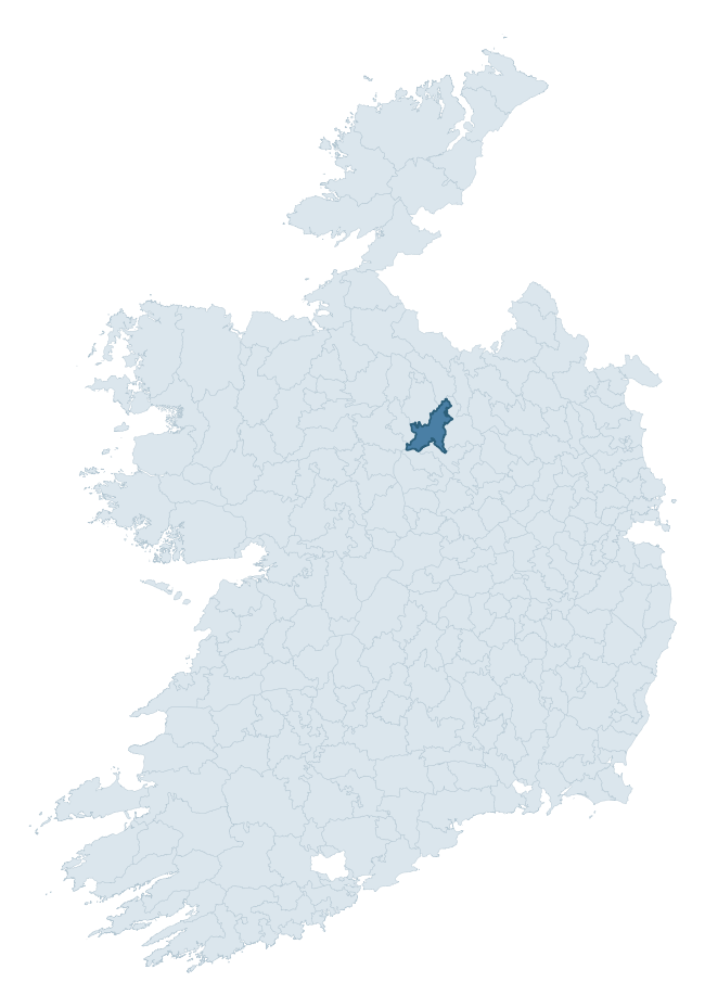
Where this barony sits in the Republic of Ireland
Geology and preservation
Bedrock geology shapes the landscape long before any settlement begins — controlling soil drainage, agricultural potential, the survival of upstanding monuments, and the preservation of buried archaeology. The figures below come from the Geological Survey Ireland 1:100,000 bedrock map.
The bedrock underlying Longford is predominantly greywacke and shale (30% of the barony by area), laid down during the Carboniferous period (59% by area, around 359 to 299 million years ago). A substantial secondary geology of limestones (29%) and limestone (16%) adds further variety to the underlying landscape. The single largest mapped unit is the Coronea Formation (30% of the barony's bedrock). With 8 distinct rock types mapped, the barony sits in the top third of ROI baronies for geological diversity (80th percentile) — typically a sign of complex tectonic history or coastal mosaics of differing rock units.
Rock type composition
Largest mapped unit: Coronea Formation (30% of the barony)
Placename evidence
Logainm records 31 heritage-diagnostic placenames for Longford, drawn from townland and civil-parish names across the barony. The dominant stratum is Early Christian ecclesiastical — cill-, teampall-, and domhnach-prefixed names that record the dense network of early church foundations established between the fifth and tenth centuries. The leading diagnostic roots are cill- (16 — church), lios- (7 — ringfort or enclosure), and ráth- (2 — earthen ringfort). This is broadly in line with the ROI average of 30.7 heritage placenames per barony. The presence of multiple heritage strata side by side indicates layered occupation of the landscape across successive prehistoric and historic periods. Logainm records 168 placenames for Longford (predominantly townland names). Of these, 31 (18%) carry one of the diagnostic Gaelic roots tracked above; the remainder draw on more generic landscape vocabulary that does not encode a heritage period.
Pre-Christian / Early Medieval Defensive
| Root | Count | Meaning |
|---|---|---|
| lios- | 7 | ringfort or enclosure |
| ráth- | 2 | earthen ringfort |
| dún- | 1 | hilltop or promontory fort |
Early Christian Ecclesiastical
| Root | Count | Meaning |
|---|---|---|
| cill- | 16 | church (early) |
| cillín- | 2 | unconsecrated burial ground |
| teampall- | 1 | church (later medieval) |
Burial, Ritual, and Norse-Contact
| Root | Count | Meaning |
|---|---|---|
| tuaim- | 1 | burial mound |
| leacht- | 1 | grave monument |
About this profile
Click any section below to expand.
What is a barony?
A barony is a historic administrative unit in Ireland, broadly equivalent to an English hundred. The 280 baronies used here are from the OSi 2019 National Statutory Boundaries (generalised 20m), covering the 26 counties of the Republic of Ireland. Baronies derive from the Norman period, were formalised in the 17th century, and have not been redrawn for statistical purposes. They vary enormously in area, from compact urban baronies in Dublin to vast upland baronies in Connacht, and should not be compared by raw site count without accounting for area differences.
What counts as a site?
This profile combines three distinct heritage registers, each with its own definition of what constitutes a recordable site:
- Archaeological sites (NMS). The National Monuments Service Sites and Monuments Record (SMR) catalogues every known archaeological monument or site of archaeological interest in the Republic, from prehistoric burial mounds and ringforts to medieval churches and post-medieval defensive works. Inclusion does not require legal protection — only that the site has been identified, surveyed, and assessed as having archaeological value. A separate subset of these sites lies within a recorded protection zone, which gives them statutory protection under the National Monuments Acts.
- Listed buildings (NIAH). The National Inventory of Architectural Heritage records buildings of architectural, historical, archaeological, artistic, cultural, scientific, social, or technical interest. Each surveyed structure is appraised on a five-tier scale: International, National, Regional, Local, and Record-Only. The NIAH appraisal is informational rather than strictly statutory, but it underpins local-authority Record of Protected Structures (RPS) listings.
- Heritage placenames (Logainm). Logainm is the authoritative database of Irish placenames maintained by the Placenames Branch. This profile applies a heritage-diagnostic classifier to the Irish-language form of each townland name, flagging roots that signal defensive sites (ráth-, lios-, dún-, caiseal-, cathair-), ecclesiastical foundations (cill-, teampall-, domhnach-, mainistir-), prehistoric burial-ritual features (tuaim-, carn-, leaba-), or Norse-contact settlement (gall-). Townlands without one of these diagnostic roots are not flagged here — they may still carry historical significance, but that significance is not encoded in the name itself.
Editorial principles
The narrative sections of this profile follow several explicit principles:
- Evidential. Every claim about this barony’s heritage character is anchored in the underlying register data. Where a site count, a placename count, or a percentile rank is cited, it is computed from the source datasets at export time, not estimated.
- Comparative. Counts and metrics are reported alongside their percentile rank against the other 279 ROI baronies. A barony with 50 ringforts in absolute terms could be unusually high or unusually low depending on its size and regional context; percentile ranking removes that ambiguity.
- Transparent on limits. Where a register has known coverage gaps, survey biases, or data-quality issues that affect this barony’s figures, the profile flags them rather than presenting the numbers as definitive.
- No interpretation beyond what the data supports. The narrative does not speculate about historical events, social dynamics, or cultural meaning beyond what the recorded heritage and placename evidence directly attests.
Data caveats and limits
- NMS Sites and Monuments Record is the product of survey campaigns conducted at different intensities across different counties and decades. Some baronies have been surveyed more thoroughly than others, and absolute counts should be read in that light. Sites destroyed by development before survey are typically not represented; sites in heavily forested or upland terrain are sometimes under-recorded.
- NIAH coverage is broadly complete for the Republic of Ireland but the survey was conducted on a rolling county-by-county basis, and the most recent appraisal date varies. Buildings demolished or substantially altered after their original survey may still appear in the register; conversely, recent buildings of merit may not yet have been appraised.
- Logainm classification applies a deliberately conservative pattern-matching approach to the Irish-language townland forms. The classifier prioritises true positives over recall: a townland may carry a heritage signal that the classifier doesn’t recognise, particularly where the diagnostic root has been heavily anglicised or where the townland name draws on a less common term. The 60,000+ townland records and ~9,800 classified placenames give a substantial signal at barony scale, but individual townland names should be checked against Logainm directly for definitive interpretation.
- Period attribution. The chronological distribution reflects only those NMS sites that carry a recognised period attribution in the source data. Sites listed as “Unknown” period are excluded from the dated subset.
- Boundary changes. Some baronies have undergone minor boundary adjustments since their 19th-century definition; the OSi 2019 generalised boundaries used here are the current statutory definition and may differ slightly from historical maps in border areas.
- Bedrock geology is mapped at 1:100,000 scale, which means local variation within a barony — small pockets of different rock type, mineral veins, alluvium overlying bedrock — is generalised. The dominant-system and rocktype figures are area-weighted, so a barony reading “70% Carboniferous limestone” may still contain small but archaeologically important pockets of older or younger rock. Around 3% of GSI polygons do not match the lexicon and contribute no rocktype or system attribution.
Data sources
- National Monuments Service — Sites and Monuments Record (SMR) https://data.gov.ie/dataset/national-monuments-service-archaeological-survey-of-ireland
- National Inventory of Architectural Heritage (NIAH) https://data.gov.ie/dataset/national-inventory-of-architectural-heritage-niah-national-dataset
- Logainm — Placenames Database of Ireland https://www.logainm.ie/
- Ordnance Survey Ireland — National Statutory Barony Boundaries 2019 https://data-osi.opendata.arcgis.com/
- EURODEM — European Digital Elevation Model https://www.mapsforeurope.org/datasets/euro-dem
- ESA WorldCover https://esa-worldcover.org/en
- Geological Survey Ireland — 1:100,000 Bedrock Geology https://www.gsi.ie/en-ie/data-and-maps/Pages/Bedrock.aspx
Explore more: Search any of the 280 ROI baronies, browse by historical province, or read the methodology and data sources for the full Republic of Ireland Heritage Tool.