
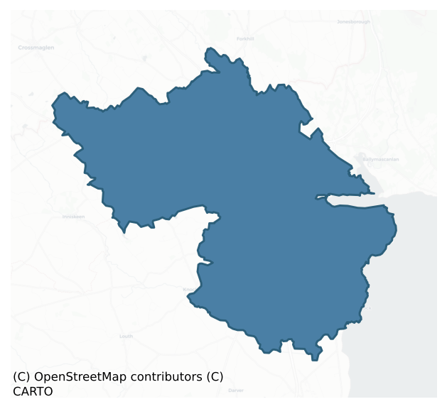
Dundalk Upper is a barony of County Louth, in the historical province of Leinster (Irish: Dún Dealgan Uachtarach), covering 126 km² of land. The barony records 543 NMS archaeological sites and 415 NIAH listed buildings, placing it at around the 94th percentile among 280 ROI baronies for sites per km². This means it is in the top tenth of all baronies for sites per km². Dated archaeological evidence runs from the Mesolithic through to the Modern, spanning 9 of 9 archaeological periods, placing the barony in the 99th percentile among 280 ROI baronies for chronological depth. This means it is in the top tenth of all baronies for chronological depth. The largest dated subset of recorded sites dates to the Early Medieval. Logainm flags 28 placenames in the barony as carrying a recognised heritage root; the largest share — around 54% — are names associated with pre-christian defensive.
Heritage at a glance
Percentile rankings throughout this profile compare each barony only against the other 279 Republic of Ireland baronies.
The recorded heritage of Dundalk Upper
The National Monuments Service Sites and Monuments Record (SMR) is the statutory inventory of archaeological sites for the Republic of Ireland, maintained by the Department of Tourism, Culture, Arts, Gaeltacht, Sport and Media. Sites recorded here include earthworks, ringforts, megalithic tombs, ecclesiastical remains, and post-medieval features; not every record is legally protected, but each is registered as a monument of archaeological interest.
The National Monuments Service records 543 archaeological sites in Dundalk Upper, putting it at the 94th percentile among 280 ROI baronies for sites per km². This means it is in the top tenth of all baronies for sites per km². Of these, 483 (89%) fall within a recorded monument protection zone. The dominant category is defensive sites — ringforts, enclosures, hillforts, and stone forts (265 sites, 49% of the record). Souterrain is the most prevalent type, making up 22% of the barony's recorded sites (122 records) — well above the ROI average of 4% across all baronies where this type occurs. Souterrain is an underground stone-built passage and chamber, generally Early Medieval and often associated with ringforts as a defensive or storage feature. Other significant types include Enclosure (50) and Ringfort – rath (49). Enclosure is a banked or ditched feature of uncertain type, used as a catch-all where the original function cannot be determined from surface evidence; Ringfort – rath is an earthen ringfort enclosed by a bank and external ditch — the most common Early Medieval farmstead, broadly dated 500–1000 AD. Across the barony's 126 km², this gives a recorded density of 4.32 sites per km².
Most common monument types
Hover or tap a monument type to see its definition.
| Type | Count |
|---|---|
| Souterrain an underground stone-built passage and chamber, generally Early Medieval and often associated with ringforts as a defensive or storage feature | 122 |
| Enclosure a banked or ditched feature of uncertain type, used as a catch-all where the original function cannot be determined from surface evidence | 50 |
| Ringfort – rath an earthen ringfort enclosed by a bank and external ditch — the most common Early Medieval farmstead, broadly dated 500–1000 AD | 49 |
| Fulacht fia a horseshoe-shaped Bronze Age burnt mound built around a sunken trough beside a water source, traditionally interpreted as a cooking site | 26 |
| Excavation – miscellaneous | 25 |
| Ring-ditch a circular ditch under 20m across, often the ploughed-out remains of a barrow, ring-barrow or roundhouse | 20 |
| Standing stone a deliberately set upright stone, used variously as a Bronze/Iron Age burial marker, route marker or commemorative monument | 18 |
| Castle – tower house a fortified residential tower of four or five storeys, mostly built by lords in the 15th and 16th centuries and often within a defended bawn | 14 |
Chronological distribution
The dated archaeological record for Dundalk Upper spans from the Mesolithic through to the Modern, with activity attested across 9 of 9 archaeological periods. This places Dundalk Upper in the top 1% of ROI baronies for chronological depth — few baronies record evidence across as many distinct archaeological periods. Every period from earliest to latest is represented in the record — an unbroken sequence of dated activity across the full chronological span. Activity concentrates most heavily in the Early Medieval (186 sites, 45% of dated material), with the Iron Age forming a secondary peak (81 sites, 20%). A further 130 recorded sites (24% of the overall NMS register for the barony) carry no period attribution — appearing as 'Unknown' in the bar chart below. This typically reflects either records that pre-date the standardised period vocabulary or sites awaiting specialist dating review, rather than a genuine absence of chronological evidence.
Sample of recorded monuments
Show 25 sample monuments (of 543 total)
A representative sample of 25 recorded monuments drawn from the barony’s 543 total NMS entries. Sites within a recorded monument protection zone and rarer site types are prioritised so the list shows a meaningful cross-section rather than only the most common type. Each entry shows the official Sites and Monuments Record reference number and the description published by the National Monuments Service.
Kiln
On the first edition of the Ordnance Survey maps a kiln is indicated just N of the mill which is also shown on the maps, being titled on later versions Dungooley Mill (Flax and Corn).
Compiled by: Margaret…
On the first edition of the Ordnance Survey maps a kiln is indicated just N of the mill which is also shown on the maps, being titled on later versions Dungooley Mill (Flax and Corn).
Compiled by: Margaret Keane
Updated on: 13 March 2018
Castle – Anglo-Norman masonry castle
Situated high up on a rock outcrop which drops away steeply on all but the E side, and said to have been built in 1236 by Lady Rohesia de Verdun, grand-daughter of Bertram de Verdun, according to a reference in the…
Situated high up on a rock outcrop which drops away steeply on all but the E side, and said to have been built in 1236 by Lady Rohesia de Verdun, grand-daughter of Bertram de Verdun, according to a reference in the Close Rolls (Sweetman 1875-86, no. 2334). The present remains, however, for the most part appear to be of a later date and were probably built by her son John, who died in 1274 (Leask 1973, 63). Richard Bellew obtained a grant in 1464 to repair the castle which was then ruinous (CLAJ 1943, 185).
The castle, constructed of roughly coursed limestone ashlar and greywacke, consists of a curtain wall enclosing a subtriangular area, within which is situated a hall at the S side, an almost centrally placed free-standing rectangular structure and the remains of a gate-building in the E wall. The curtain walls rise directly from the edge of the bedrock on all but the NW side where the remains of a battered plinth can be seen. This section of the curtain, as well as the portion of the E wall which lies to the N of the gateway, has well-preserved merlons with rectangular holes below them at wall-walk level. These holes may have been used to carry a hourd or were possibly merely drain holes.
The gateway, situated in the S end of the E wall, is cut off from a plateau to its E by a wide shallow rock-cut fosse; it consists of twin towers, sub-rectangular in plan behind the line of the curtain but almost semi-circular to the front. They are pierced by a wide entrance whi…
Settlement deserted – medieval
To the E of Roche castle (LH003-029001-), and divided from it by a wide rock-cut fosse, is a large plateau on which is thought to have been sited a medieval borough. Evidence of the borough is slight, but a weekly…
To the E of Roche castle (LH003-029001-), and divided from it by a wide rock-cut fosse, is a large plateau on which is thought to have been sited a medieval borough. Evidence of the borough is slight, but a weekly market and an annual eight-day fair had been established by 1284 and the borough is specifically mentioned in 1332 (Bradley and King 1985, 52-3). The remains of a boundary wall and tower at the NW corner, as well as a number of rectangular features within, can still be seen.
Compiled by: Claire Breen
Date of upload: 10 November 2011
Enclosure – large enclosure
The following description is derived from both the published 'Archaeological Inventory of County Louth' (Dublin: Stationery Office, 1986) and the 'Archaeological Survey of County Louth' (Dublin: Stationery Office,…
The following description is derived from both the published 'Archaeological Inventory of County Louth' (Dublin: Stationery Office, 1986) and the 'Archaeological Survey of County Louth' (Dublin: Stationery Office, 1991). In certain instances the entries have been revised and updated in the light of recent research.
Date of upload/revision: 17 July 2007
Cropmarks representing oval enclosure (max. dims. c. 82m NW-SE, c. 60m SW-NE) defined by two widely-spaced ditches on aerial photographs (CUCAP, ALK 12, APG 78). Two areas of burnt stone (LH003-031002- and LH003-031003-) visible on the site in 1966.
Megalithic tomb – wedge tomb
The following description is derived from both the published 'Archaeological Inventory of County Louth' (Dublin: Stationery Office, 1986) and the 'Archaeological Survey of County Louth' (Dublin: Stationery Office,…
The following description is derived from both the published 'Archaeological Inventory of County Louth' (Dublin: Stationery Office, 1986) and the 'Archaeological Survey of County Louth' (Dublin: Stationery Office, 1991). In certain instances the entries have been revised and updated in the light of recent research.
Date of upload/revision: 17 July 2007
The monument is 160m NW of portal-tomb (LH004-056—-). Situated on the W side of the valley of the Kilcurry River. It consists of a substantial grass-grown oblong mound (L 12m; max. Wth 7m; max. H 1m) in which there is the remains of a long gallery, aligned NNE-SSW. Two clumps of white-thorn trees grow on the S end of the mound. The monument was listed as an unclassified megalithic tomb (Ó Nualláin 1989; Ó Nualláin & Walsh 1986a, 1991) but following a more recent examination it is clear that it is a wedge-tomb.
The gallery (at least 4.5m long) is aligned almost due N-S with the entrance at the S end. A large septal-stone marks the S end of the gallery.The E side of the gallery is represented by at least five stones but only two possible sidestones are visible on the W side. Near the N end of the mound is a low set stone with a gabled top. It may be a backstone or a kerb-stone. A prostrate slab in the gallery area may be a displaced roofstone.
Megalithic tomb – portal tomb
The following description is derived from both the published 'Archaeological Inventory of County Louth' (Dublin: Stationery Office, 1986) and the 'Archaeological Survey of County Louth' (Dublin: Stationery Office,…
The following description is derived from both the published 'Archaeological Inventory of County Louth' (Dublin: Stationery Office, 1986) and the 'Archaeological Survey of County Louth' (Dublin: Stationery Office, 1991). In certain instances the entries have been revised and updated in the light of recent research.
Date of upload/revision: 17 July 2007
The remains of this portal-tomb are 160m SE of wedge-tomb (LH004-055—-). All that survives is a portal stone, 2.5m high, and a prostrate roof stone measuring 3.7m by 2.9m by 1.2m (CLAJ 1910, 300).
Moated site
The following description is derived from both the published 'Archaeological Inventory of County Louth' (Dublin: Stationery Office, 1986) and the 'Archaeological Survey of County Louth' (Dublin: Stationery Office,…
The following description is derived from both the published 'Archaeological Inventory of County Louth' (Dublin: Stationery Office, 1986) and the 'Archaeological Survey of County Louth' (Dublin: Stationery Office, 1991). In certain instances the entries have been revised and updated in the light of recent research.
Date of upload/revision: 17 July 2007
Situated on the summit of a low NW-SE ridge and consisting of an almost square area (38m NW-SE by 37.5m NE-SW) enclosed by two well-defined banks and intervening fosse (Wth at base on inner bank c. 10m at NW, int. H 1m, ext. c. 2.3m, fosse max. Wth at NW 7m, Wth at base of outer bank 4.5m at NW, int. H 1.9m, ext. 0.6m). There is a well defined entrance, probably modern, at the SW with a causeway across the fosse. The interior of the enclosure is slightly higher than the level of the surrounding land. The inner bank is best perserved at the NW and NE; elsewhere it is defaced to varying degrees. The outer bank is fairly slight, especially on either side of the entrance. The banks contain a large amount of stone and may possibly have been partially stone-faced.
Megalithic tomb – passage tomb
The following description is derived from both the published 'Archaeological Inventory of County Louth' (Dublin: Stationery Office, 1986) and the 'Archaeological Survey of County Louth' (Dublin: Stationery Office,…
The following description is derived from both the published 'Archaeological Inventory of County Louth' (Dublin: Stationery Office, 1986) and the 'Archaeological Survey of County Louth' (Dublin: Stationery Office, 1991). In certain instances the entries have been revised and updated in the light of recent research.
In 1758 Wright published diagrammatic plans and sketches of two hilltop monuments; the larger monument on the main hilltop had 'rude carvings' similar to those at Newgrange (Wright 1758, pls 6, 7). This monument was destroyed by quarrying in 1826 (CLAJ 1907, 60). A decorated stone from the site, published by Evans (1939, 250-4), now lies on the top of Killin Hill at the spot marked 'Druid's Circle (site of)' on the current OS six-inch map. The nineteenth-century descriptions and surviving stone leave little doubt that this monument was a megalithic tomb of the passage-tomb class (see also LH006-015002-).
Levelled monument described by Evans (1939, 250-2) as follows; 'The hill rises in two steep summits above the surrounding country, but has been so extensively quarried for limestone that it is difficult to reconstruct the original topography or to relate it to Wright's sketch which is reproduced here. The megaliths, for there were two separate structures, were "completely cleared away" during quarrying operations in the early nineteenth century. Wright's diagrammatic plan and sketch show a stone circle on each summit. The account is very confused and th…
Passage tomb art
The following description is derived from both the published 'Archaeological Inventory of County Louth' (Dublin: Stationery Office, 1986) and the 'Archaeological Survey of County Louth' (Dublin: Stationery Office,…
The following description is derived from both the published 'Archaeological Inventory of County Louth' (Dublin: Stationery Office, 1986) and the 'Archaeological Survey of County Louth' (Dublin: Stationery Office, 1991). In certain instances the entries have been revised and updated in the light of recent research.
Stone bearing passage-grave art is now all that remains of a megalithic tomb (see LH006-015001-) which was destroyed by quarrying in 1826. Decorated stone described by Evans (1939, 250-4) as follows; 'When Mr. H. G. Tempest first took me to the site in 1934 he showed me a large stone lying on the lower hill-top. This, on being turned over, seemed to have traces of engravings. It was not until January, 1938, that I had an opportunity of visiting the hill again, in company with Miss M. Gaffikin, Mr. O. Davies, and Mr. T. G. F. Paterson, when we obtained the rubbing reproduced in fig. 2 and the photograph. The surface of the limestone is so weathered that the markings do not stand out clearly, but we were all satisfied of their genuineness. The minor irregularities of the surface may be due to its having been dressed to take the carvings. Part of what looks like a large spiral can be made out, and an arrangement of concentric lozenges, while there are traces of what appear to be concentric circles between them. The stone is cigar-shaped, measuring 4 ft. 10 in. [1.47m] in length and 18 in. [0.45m] in maximum breadth. One end is broken, and close by is a socket, I…
Megalithic tomb – unclassified
The following description is derived from both the published 'Archaeological Inventory of County Louth' (Dublin: Stationery Office, 1986) and the 'Archaeological Survey of County Louth' (Dublin: Stationery Office,…
The following description is derived from both the published 'Archaeological Inventory of County Louth' (Dublin: Stationery Office, 1986) and the 'Archaeological Survey of County Louth' (Dublin: Stationery Office, 1991). In certain instances the entries have been revised and updated in the light of recent research.
Date of upload/revision: 17 July 2007
This, the second of the two monuments published by Wright in 1758 (see also LH006-015001-), stood on a lower hill nearby. His plan shows two concentric rings which appear to represent a cairn of somewhat smaller dimensions than LH006-015001-. He gives no description of this monument, but its proximity to the other cairn and its hilltop siting indicate that it too may have been a passage-tomb. It is not now possible to locate the precise site of this monument which was probably destroyed together with the main hilltop site in the early nineteenth century. (CLAJ 1907, 60)
Pit-burial
The following description is derived from both the published 'Archaeological Inventory of County Louth' (Dublin: Stationery Office, 1986) and the 'Archaeological Survey of County Louth' (Dublin: Stationery Office,…
The following description is derived from both the published 'Archaeological Inventory of County Louth' (Dublin: Stationery Office, 1986) and the 'Archaeological Survey of County Louth' (Dublin: Stationery Office, 1991). In certain instances the entries have been revised and updated in the light of recent research.
Date of upload/revision: 17 July 2007
Found during ploughing on the slope of a fairly steep hill. The pit was circular in plan (diam. c. 0.7m, D c. 0.9m), cut into the boulder clay, and contained charcoal and two Cordoned Urns (Kavanagh 1976, 368, Nos 33, 34). (CLAJ 1928, 256-60)
Windmill
Indicated on Taylor and Skinner's map (1777) and named 'Old Windmill' on the 1835 'OS 6- inch' map. Situated on flat topped, stone faced mound (diam. 28m). Three storeys high with two opposing doors and windows. A date…
Indicated on Taylor and Skinner's map (1777) and named 'Old Windmill' on the 1835 'OS 6- inch' map. Situated on flat topped, stone faced mound (diam. 28m). Three storeys high with two opposing doors and windows. A date of 1702 is inscribed on a stone here. (SMR file)
Compiled by: Claire Breen
Date of upload: 23 November 2011
Mass-rock
Section of rock outcrop known locally as 'Carrickadare' and claimed to be a mass rock (CLAJ 7, 1931, 382-3).
Compiled by: Claire Breen
Date of upload: 23 November 2011
Standing stone – pair
Wright illustrates two 'stone pillars' (Wright 1758, Book 3, p. 7-8, Pl. 1, Site F). No visible trace survives.
Reference:
Wright, T. 1758 Louthiana: or an introduction to the antiquities of Ireland. London.…
Wright illustrates two 'stone pillars' (Wright 1758, Book 3, p. 7-8, Pl. 1, Site F). No visible trace survives.
Reference:
Wright, T. 1758 Louthiana: or an introduction to the antiquities of Ireland. London. Thomas Payne.
Compiled by: Claire Breen
Date of upload: 23 November 2011
Crannog
The following description is derived from both the published 'Archaeological Inventory of County Louth' (Dublin: Stationery Office, 1986) and the 'Archaeological Survey of County Louth' (Dublin: Stationery Office,…
The following description is derived from both the published 'Archaeological Inventory of County Louth' (Dublin: Stationery Office, 1986) and the 'Archaeological Survey of County Louth' (Dublin: Stationery Office, 1991). In certain instances the entries have been revised and updated in the light of recent research.
Date of upload/revision: 17 July 2007
Circular platform of earth and stones (diam. 22m) with traces of a kerb of large boulders forming the perimeter. The site is located in a marshy hollow, probably formerly a small lough. (CLAJ 1978, 166)
Ogham stone
This ogham stone was discovered in 1977 in the course of an excavation of a souterrain (LH007-072005-) where it was used as a lintel. It is part of the National Museum of Ireland collection and is currently on display…
This ogham stone was discovered in 1977 in the course of an excavation of a souterrain (LH007-072005-) where it was used as a lintel. It is part of the National Museum of Ireland collection and is currently on display in the County Museum, Dundalk (see LH007-188—-). 'The top has been broken off, probably as part of the appropriation for use in the souterrain. Though incised very finely the consonants are legible but the vowel notches were not cut very deeply and many are uncertain (indicated here by lower-case or a dot). The inscription reads up both angles as follows: Left angle: MAQI CORaBiR MaQi? TAN.b/l … Right angle: NeTa SaLaGIa MAQi MuCoi … (McManus 1991, 76, no. xvii).
Compiled by: Nora White
Date of upload: 12 February 2017
Bridge
The following description is derived from both the published 'Archaeological Inventory of County Louth' (Dublin: Stationery Office, 1986) and the 'Archaeological Survey of County Louth' (Dublin: Stationery Office,…
The following description is derived from both the published 'Archaeological Inventory of County Louth' (Dublin: Stationery Office, 1986) and the 'Archaeological Survey of County Louth' (Dublin: Stationery Office, 1991). In certain instances the entries have been revised and updated in the light of recent research.
Date of upload/revision: 17 July 2007
Situated over the Castletown River NW of Castletown Castle, it was built by John Bellew and Dame Mary Birmingham in 1674, according to a stone plaque in the centre of the W wall of the structure. The bridge was repaired in 1880 and the stone plaque re-set. On the upper portion of the stone there is a wreath within which are the arms of Sir John Bellew and his wife. On the lower half of the plaque is the inscription. The stone plaque is slightly recessed and is capped by a late medieval jamb stone from a window. The bridge has five eyes and is built of limestone blocks and greywacke, but the top of the walls have been replaced with modern cut stone. (CLAJ 1905, 23-4)
Stone head
The following description is derived from both the published 'Archaeological Inventory of County Louth' (Dublin: Stationery Office, 1986) and the 'Archaeological Survey of County Louth' (Dublin: Stationery Office,…
The following description is derived from both the published 'Archaeological Inventory of County Louth' (Dublin: Stationery Office, 1986) and the 'Archaeological Survey of County Louth' (Dublin: Stationery Office, 1991). In certain instances the entries have been revised and updated in the light of recent research.
Date of upload/revision: 17 July 2007
Set into a modern wall to the S of Castletown Castle, this is a very good example of a mouth-puller with the typical bulging eyes, exposed teeth and exaggerated wrinkles all over the face and head. The hands come from behind the head and have the thumbs pointing upwards. All the other fingers are inserted in the mouth rather than merely the forefinger as in the French examples. (CLAJ 1977, 69; Weir and Jerman 1986, 104-5, pl. 54)
Cist (present location)
A cist burial discovered at Tankardsrock (see LH006-037—-) was reconstructed in the avenue bank of Dun Dealgan motte (LH007-118007-).
Compiled by: Claire Breen
Date of upload: 24 November 2011
Slab-lined burial
The following description is derived from both the published 'Archaeological Inventory of County Louth' (Dublin: Stationery Office, 1986) and the 'Archaeological Survey of County Louth' (Dublin: Stationery Office,…
The following description is derived from both the published 'Archaeological Inventory of County Louth' (Dublin: Stationery Office, 1986) and the 'Archaeological Survey of County Louth' (Dublin: Stationery Office, 1991). In certain instances the entries have been revised and updated in the light of recent research.
Date of upload/revision: 17 July 2007
Long cist, aligned E-W, containing an extended inhumation, above which were scattered the bones of at least six adults.
Meeting-house
The Archaeological Survey of Ireland (ASI) is in the process of providing information on all monuments on The Historic Environment Viewer (HEV). Currently the information for this record has not been uploaded. To…
The Archaeological Survey of Ireland (ASI) is in the process of providing information on all monuments on The Historic Environment Viewer (HEV). Currently the information for this record has not been uploaded. To access available information for research purposes please make an appointment in advance with the Archive Unit (open Fridays 10.00 am – 5.00 pm), Department of Culture, Heritage and the Gaeltacht, The Custom House, Dublin 1 D01W6XO or email nmarchive@chg.gov.ie.
Market-house
According to Gosling (1982, 162, No. 24; 1991, fig. 20, No. 5) this is the site of a structure known as the tholsel, one of a number of buildings known to have stood in the medieval town of Dundalk. It may have been one…
According to Gosling (1982, 162, No. 24; 1991, fig. 20, No. 5) this is the site of a structure known as the tholsel, one of a number of buildings known to have stood in the medieval town of Dundalk. It may have been one of the '18 or 20 ruinous remains of small castles or defensive towers' said to have been removed at Lord Limerick's insistence c. 1747. (CLAJ 1963, 287-8; Bradley and King 1985, 127)
The above description is derived from both the published 'Archaeological Inventory of County Louth' (Dublin: Stationery Office, 1986) and the 'Archaeological Survey of County Louth' (Dublin: Stationery Office, 1991). In certain instances the entries have been revised and updated in the light of recent research.
Date of revision: 22 April 2016
Religious house – Fratres Cruciferi
The following description is derived from both the published 'Archaeological Inventory of County Louth' (Dublin: Stationery Office, 1986) and the 'Archaeological Survey of County Louth' (Dublin: Stationery Office,…
The following description is derived from both the published 'Archaeological Inventory of County Louth' (Dublin: Stationery Office, 1986) and the 'Archaeological Survey of County Louth' (Dublin: Stationery Office, 1991). In certain instances the entries have been revised and updated in the light of recent research.
Date of upload/revision: 17 July 2007
Priory of St. Leonard, Fratres Cruciferi, founded by Bertram or Nicholas de Verdun in the twelfth century and situated in the grounds of the present county library. Possibly same as Leper Hospital of St. Mary Magdalene, recorded in the Monastic Extents as the hospital of the Crutched Friars of St Leonard, Dundalk (JKAHS 1966-7, 144). Only a pointed featureless barrel vault, probably part of the domestic quarters, now remains (CLAJ 1941, 19-20). Stone lined graves, part of the monastic burial ground , were found earlier this century (See LH007-119036-). (JRSAI 1908, 300-2; CLAJ 1941, 19-20; CLAJ 1948, 315; Gwynn and Hadcock 1988, 212-13; Tempest 1952a).
Discovery of human remains resulted in archaeological investigations during the 1990s (Halpin 1992, 33-4; Campbell 1996, 65; Campbell 1997a, 79).
Town defences
The following description is derived from both the published 'Archaeological Inventory of County Louth' (Dublin: Stationery Office, 1986) and the 'Archaeological Survey of County Louth' (Dublin: Stationery Office,…
The following description is derived from both the published 'Archaeological Inventory of County Louth' (Dublin: Stationery Office, 1986) and the 'Archaeological Survey of County Louth' (Dublin: Stationery Office, 1991). In certain instances the entries have been revised and updated in the light of recent research.
Date of upload/revision: 17 July 2007
The town wall of Dundalk enclosed an irregularly shaped elongated area of roughly 19 hectares (48 acres). Town defences investigated by Gosling (1982, 43-6) and Bradley (1984b, 128-30).
A small scale excavation on Clanbrassil Street (Excavation Licence 95E0168) revealed a section of the medieval town ditch. This excavation was the first to establish an exact location for the town defences. (McConway, 1995a)
Souterrain
Local tradition of a 'cave' on 'Carrick Philip', a natural hillock, close to a possible castle site (LH006-091002-). (Corcoran 1932, 497).
The above description is derived from both the published 'Archaeological…
Local tradition of a 'cave' on 'Carrick Philip', a natural hillock, close to a possible castle site (LH006-091002-). (Corcoran 1932, 497).
The above description is derived from both the published 'Archaeological Inventory of County Louth' (Dublin: Stationery Office, 1986) and the 'Archaeological Survey of County Louth' (Dublin: Stationery Office, 1991). In certain instances the entries have been revised and updated in the light of recent research.
Date of upload: 17 July 2007
Listed buildings
The National Inventory of Architectural Heritage (NIAH) is a state survey appraising buildings of architectural, historical, archaeological, artistic, cultural, scientific, social, or technical interest. Each surveyed structure receives a rating from International (the highest, for buildings of European importance) through National, Regional, Local, and Record-Only.
The National Inventory of Architectural Heritage records 415 listed buildings in Dundalk Upper, placing it in the top 7% of ROI baronies for listed-building density. The highest-graded structures include 2 of National significance. The Republic holds 937 National-graded buildings in total, so this barony accounts for around 0% of the national total. Construction dates concentrate most heavily in the Victorian (1830-1900) period. The most-recorded building type is house (272 examples, 66% of the listed stock).
Terrain and environment
Mean elevation across the barony is 36m — the 9th percentile among 280 ROI baronies for elevation. This means it is in the bottom tenth of all baronies for elevation. This is a relatively low-lying landscape by ROI standards. Elevation matters for heritage because higher-altitude baronies typically favour defensive monuments — ringforts and hilltop forts placed on prominent ground — while lowland baronies are more likely to carry the dense settlement and church networks of intensive agricultural landscapes. Mean slope is 3.1° — the 40th percentile among 280 ROI baronies for slope. This means it is in the lower half of all baronies for slope. Slope is a key control on both land use and archaeological preservation: steep ground resists ploughing and tends to preserve earthworks intact, while gentle slopes favour intensive cultivation that damages or destroys surface archaeology over time. The Topographic Wetness Index averages 11.0, the 57th percentile among 280 ROI baronies for wetness. This means it is in the upper half of all baronies for wetness. Drainage matters for heritage because poorly-drained ground preserves organic archaeology (wooden trackways, leather, textiles, and on rare occasions human remains) far better than free-draining soil; well-drained ground favours arable use but destroys organic material rapidly. Urban land covers 8% of the barony (the 94th percentile among 280 ROI baronies for urban cover. This means it is in the top tenth of all baronies for urban cover). Heavy urban coverage compresses heritage analysis: many archaeological features have been buried or destroyed by development, but the surviving record is concentrated in protected city-centre cores, and the NIAH listed-buildings count is typically high. The land-cover mosaic combines improved grassland (68%), arable farmland (14%), and woodland (9%), giving a mixed agricultural and semi-natural landscape.
Terrain measurements
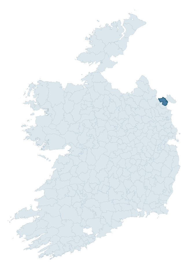
Where this barony sits in the Republic of Ireland
Geology and preservation
Bedrock geology shapes the landscape long before any settlement begins — controlling soil drainage, agricultural potential, the survival of upstanding monuments, and the preservation of buried archaeology. The figures below come from the Geological Survey Ireland 1:100,000 bedrock map.
The bedrock underlying Dundalk Upper is predominantly greywacke (90% of the barony by area), laid down during the Silurian period (90% by area, around 444 to 419 million years ago). Greywacke is a hard, dark, fine-grained sandstone that weathers to thin upland soils. Greywacke baronies typically carry sparser settlement archaeology but provide high-quality building stone visible in older field walls and farm buildings. The single largest mapped unit is the Clontail Formation (88% of the barony's bedrock). With only 2 distinct rock types mapped, the barony is geologically uniform compared to the rest of the Republic (19th percentile for diversity) — a single coherent bedrock landscape.
Rock type composition
Largest mapped unit: Clontail Formation (88% of the barony)
Placename evidence
Logainm records 28 heritage-diagnostic placenames for Dundalk Upper, drawn from townland and civil-parish names across the barony. The dominant stratum is pre-Christian and Early Medieval defensive — ráth-, lios-, dún-, and caiseal-prefixed names that mark Iron Age and early historic settlement. The leading diagnostic roots are ráth- (6 — earthen ringfort), dún- (6 — hilltop fort or promontory fort), and cill- (6 — church). This is broadly in line with the ROI average of 30.7 heritage placenames per barony. The presence of multiple heritage strata side by side indicates layered occupation of the landscape across successive prehistoric and historic periods. Logainm records 135 placenames for Dundalk Upper (predominantly townland names). Of these, 28 (21%) carry one of the diagnostic Gaelic roots tracked above; the remainder draw on more generic landscape vocabulary that does not encode a heritage period.
Pre-Christian / Early Medieval Defensive
| Root | Count | Meaning |
|---|---|---|
| ráth- | 6 | earthen ringfort |
| dún- | 6 | hilltop or promontory fort |
| lios- | 3 | ringfort or enclosure |
Early Christian Ecclesiastical
| Root | Count | Meaning |
|---|---|---|
| cill- | 6 | church (early) |
| domhnach- | 1 | pre-Patrician or earliest Patrician church |
| cillín- | 1 | unconsecrated burial ground |
| bile- | 1 | sacred tree / boundary marker |
Burial, Ritual, and Norse-Contact
| Root | Count | Meaning |
|---|---|---|
| carn- | 4 | cairn |
| gall- | 2 | foreigner — Norse settlement marker |
Other baronies in Louth
About this profile
Click any section below to expand.
What is a barony?
A barony is a historic administrative unit in Ireland, broadly equivalent to an English hundred. The 280 baronies used here are from the OSi 2019 National Statutory Boundaries (generalised 20m), covering the 26 counties of the Republic of Ireland. Baronies derive from the Norman period, were formalised in the 17th century, and have not been redrawn for statistical purposes. They vary enormously in area, from compact urban baronies in Dublin to vast upland baronies in Connacht, and should not be compared by raw site count without accounting for area differences.
What counts as a site?
This profile combines three distinct heritage registers, each with its own definition of what constitutes a recordable site:
- Archaeological sites (NMS). The National Monuments Service Sites and Monuments Record (SMR) catalogues every known archaeological monument or site of archaeological interest in the Republic, from prehistoric burial mounds and ringforts to medieval churches and post-medieval defensive works. Inclusion does not require legal protection — only that the site has been identified, surveyed, and assessed as having archaeological value. A separate subset of these sites lies within a recorded protection zone, which gives them statutory protection under the National Monuments Acts.
- Listed buildings (NIAH). The National Inventory of Architectural Heritage records buildings of architectural, historical, archaeological, artistic, cultural, scientific, social, or technical interest. Each surveyed structure is appraised on a five-tier scale: International, National, Regional, Local, and Record-Only. The NIAH appraisal is informational rather than strictly statutory, but it underpins local-authority Record of Protected Structures (RPS) listings.
- Heritage placenames (Logainm). Logainm is the authoritative database of Irish placenames maintained by the Placenames Branch. This profile applies a heritage-diagnostic classifier to the Irish-language form of each townland name, flagging roots that signal defensive sites (ráth-, lios-, dún-, caiseal-, cathair-), ecclesiastical foundations (cill-, teampall-, domhnach-, mainistir-), prehistoric burial-ritual features (tuaim-, carn-, leaba-), or Norse-contact settlement (gall-). Townlands without one of these diagnostic roots are not flagged here — they may still carry historical significance, but that significance is not encoded in the name itself.
Editorial principles
The narrative sections of this profile follow several explicit principles:
- Evidential. Every claim about this barony’s heritage character is anchored in the underlying register data. Where a site count, a placename count, or a percentile rank is cited, it is computed from the source datasets at export time, not estimated.
- Comparative. Counts and metrics are reported alongside their percentile rank against the other 279 ROI baronies. A barony with 50 ringforts in absolute terms could be unusually high or unusually low depending on its size and regional context; percentile ranking removes that ambiguity.
- Transparent on limits. Where a register has known coverage gaps, survey biases, or data-quality issues that affect this barony’s figures, the profile flags them rather than presenting the numbers as definitive.
- No interpretation beyond what the data supports. The narrative does not speculate about historical events, social dynamics, or cultural meaning beyond what the recorded heritage and placename evidence directly attests.
Data caveats and limits
- NMS Sites and Monuments Record is the product of survey campaigns conducted at different intensities across different counties and decades. Some baronies have been surveyed more thoroughly than others, and absolute counts should be read in that light. Sites destroyed by development before survey are typically not represented; sites in heavily forested or upland terrain are sometimes under-recorded.
- NIAH coverage is broadly complete for the Republic of Ireland but the survey was conducted on a rolling county-by-county basis, and the most recent appraisal date varies. Buildings demolished or substantially altered after their original survey may still appear in the register; conversely, recent buildings of merit may not yet have been appraised.
- Logainm classification applies a deliberately conservative pattern-matching approach to the Irish-language townland forms. The classifier prioritises true positives over recall: a townland may carry a heritage signal that the classifier doesn’t recognise, particularly where the diagnostic root has been heavily anglicised or where the townland name draws on a less common term. The 60,000+ townland records and ~9,800 classified placenames give a substantial signal at barony scale, but individual townland names should be checked against Logainm directly for definitive interpretation.
- Period attribution. The chronological distribution reflects only those NMS sites that carry a recognised period attribution in the source data. Sites listed as “Unknown” period are excluded from the dated subset.
- Boundary changes. Some baronies have undergone minor boundary adjustments since their 19th-century definition; the OSi 2019 generalised boundaries used here are the current statutory definition and may differ slightly from historical maps in border areas.
- Bedrock geology is mapped at 1:100,000 scale, which means local variation within a barony — small pockets of different rock type, mineral veins, alluvium overlying bedrock — is generalised. The dominant-system and rocktype figures are area-weighted, so a barony reading “70% Carboniferous limestone” may still contain small but archaeologically important pockets of older or younger rock. Around 3% of GSI polygons do not match the lexicon and contribute no rocktype or system attribution.
Data sources
- National Monuments Service — Sites and Monuments Record (SMR) https://data.gov.ie/dataset/national-monuments-service-archaeological-survey-of-ireland
- National Inventory of Architectural Heritage (NIAH) https://data.gov.ie/dataset/national-inventory-of-architectural-heritage-niah-national-dataset
- Logainm — Placenames Database of Ireland https://www.logainm.ie/
- Ordnance Survey Ireland — National Statutory Barony Boundaries 2019 https://data-osi.opendata.arcgis.com/
- EURODEM — European Digital Elevation Model https://www.mapsforeurope.org/datasets/euro-dem
- ESA WorldCover https://esa-worldcover.org/en
- Geological Survey Ireland — 1:100,000 Bedrock Geology https://www.gsi.ie/en-ie/data-and-maps/Pages/Bedrock.aspx
Explore more: Search any of the 280 ROI baronies, browse by historical province, or read the methodology and data sources for the full Republic of Ireland Heritage Tool.