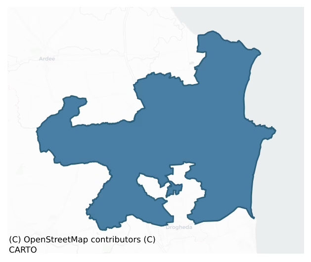
Ferrard is a barony of County Louth, in the historical province of Leinster (Irish: Fir Arda), covering 200 km² of land. The barony records 442 NMS archaeological sites and 184 NIAH listed buildings, placing it at around the 61st percentile among 280 ROI baronies for sites per km². This means it is in the upper half of all baronies for sites per km². Dated archaeological evidence runs from the Mesolithic through to the Modern, spanning 9 of 9 archaeological periods, placing the barony in the 100th percentile among 280 ROI baronies for chronological depth. This means it is in the top tenth of all baronies for chronological depth. The largest dated subset of recorded sites dates to the Iron Age. Logainm flags 23 placenames in the barony as carrying a recognised heritage root; the largest share — around 52% — are names associated with pre-christian defensive.
Heritage at a glance
Percentile rankings throughout this profile compare each barony only against the other 279 Republic of Ireland baronies.
The recorded heritage of Ferrard
The National Monuments Service Sites and Monuments Record (SMR) is the statutory inventory of archaeological sites for the Republic of Ireland, maintained by the Department of Tourism, Culture, Arts, Gaeltacht, Sport and Media. Sites recorded here include earthworks, ringforts, megalithic tombs, ecclesiastical remains, and post-medieval features; not every record is legally protected, but each is registered as a monument of archaeological interest.
The National Monuments Service records 442 archaeological sites in Ferrard, putting it at the 61st percentile among 280 ROI baronies for sites per km². This means it is in the upper half of all baronies for sites per km². Of these, 392 (89%) fall within a recorded monument protection zone. The record is dominated by defensive sites — ringforts, enclosures, hillforts, and stone forts (141 sites, 32% of the total), with ecclesiastical sites forming a substantial secondary presence (88 sites, 20%). The most diagnostically specific type is Souterrain (36 records, 8% of the barony's NMS total) — compared to an ROI average of 4% across all baronies where this type occurs. Souterrain is an underground stone-built passage and chamber, generally Early Medieval and often associated with ringforts as a defensive or storage feature. The broader 'Enclosure' classification — which catches unclassified ringforts and field enclosures — accounts for a further 66 records (15%) and reflects the difficulty of sub-classifying degraded earthworks from surface evidence alone. Across the barony's 200 km², this gives a recorded density of 2.21 sites per km².
Most common monument types
Hover or tap a monument type to see its definition.
| Type | Count |
|---|---|
| Enclosure a banked or ditched feature of uncertain type, used as a catch-all where the original function cannot be determined from surface evidence | 66 |
| Souterrain an underground stone-built passage and chamber, generally Early Medieval and often associated with ringforts as a defensive or storage feature | 36 |
| Church a building used for public Christian worship, of any date from c. 500 AD onwards | 32 |
| Ringfort – rath an earthen ringfort enclosed by a bank and external ditch — the most common Early Medieval farmstead, broadly dated 500–1000 AD | 22 |
| Graveyard a burial area associated with a church, in use from the medieval period onwards | 21 |
| Fulacht fia a horseshoe-shaped Bronze Age burnt mound built around a sunken trough beside a water source, traditionally interpreted as a cooking site | 20 |
| Ritual site – holy well a well or spring traditionally associated with a saint, often credited with healing properties; many trace earlier ritual origins but devotion is documented from the medieval period onwards | 16 |
| Barrow – unclassified a prehistoric burial mound where the specific barrow type cannot be determined from surface evidence | 16 |
Chronological distribution
The dated archaeological record for Ferrard spans from the Mesolithic through to the Modern, with activity attested across 9 of 9 archaeological periods. This places Ferrard in the top 0% of ROI baronies for chronological depth — few baronies record evidence across as many distinct archaeological periods. Every period from earliest to latest is represented in the record — an unbroken sequence of dated activity across the full chronological span. Activity concentrates most heavily in the Iron Age (92 sites, 32% of dated material), with the Early Medieval forming a secondary peak (87 sites, 30%). A further 153 recorded sites (35% of the overall NMS register for the barony) carry no period attribution — appearing as 'Unknown' in the bar chart below. This typically reflects either records that pre-date the standardised period vocabulary or sites awaiting specialist dating review, rather than a genuine absence of chronological evidence.
Sample of recorded monuments
Show 25 sample monuments (of 442 total)
A representative sample of 25 recorded monuments drawn from the barony’s 442 total NMS entries. Sites within a recorded monument protection zone and rarer site types are prioritised so the list shows a meaningful cross-section rather than only the most common type. Each entry shows the official Sites and Monuments Record reference number and the description published by the National Monuments Service.
Mine
Lead and copper mine noted by Bassett (1886, 243). Now closed.
Compiled by: Claire Breen
Date of upload: 19 June 2012
Hermitage
Marked as 'Hermitage' on the 1835 'OS 6-inch' map and 'Hermitage (in Ruins)' on the 1911 'OS 6-inch map'. When inspected by ASI in 1966 it was described as a small rectangular structure (Int. dims. 8m x 4m), in a…
Marked as 'Hermitage' on the 1835 'OS 6-inch' map and 'Hermitage (in Ruins)' on the 1911 'OS 6-inch map'. When inspected by ASI in 1966 it was described as a small rectangular structure (Int. dims. 8m x 4m), in a ruinous state with a bricked interior and boulders on the exterior.
Compiled by: Claire Breen
Date of upload: 4 July 2012
House – 18th/19th century
The following description is derived from both the published 'Archaeological Inventory of County Louth' (Dublin: Stationery Office, 1986) and the 'Archaeological Survey of County Louth' (Dublin: Stationery Office,…
The following description is derived from both the published 'Archaeological Inventory of County Louth' (Dublin: Stationery Office, 1986) and the 'Archaeological Survey of County Louth' (Dublin: Stationery Office, 1991). In certain instances the entries have been revised and updated in the light of recent research.
Date of upload/revision: 17 July 2007
L-shaped, two storeyed structure with thatched roof, built of roughly-coursed and loosely-bonded stone. It was built in two phases with the original structure consisting of a rectangular house (long axis N-S) and the slightly later addition extending E from the N gable end. The extension was not just built against the gable but incorporated most of the N end of the original house. This gives the front or E side of the house a very unbalanced look, which is exaggerated by the fact that the extension was not built at right angles to the original structure. The entrance way is through a small porch, a later addition, with a fanlight window over the door. Most of the windows have machine-cut limestone sills, which must also be later additions, and wooden lintels. The S and E gables have slight projections; that at the S rises from the ground level, that at the E from the first floor, which carried the chimney flues. At present there are three chimney stacks, none of which appear to relate to the projections on the gables and must be later additions. The house has not been occupied since 1982 and is inaccessible owing to its…
Designed landscape – tree-ring
An approximately oval area surrounded by a large bank, a fosse and an outer 'bank' in places with an entrance at NNW. It has the appearance of a ringfort, but the fresh cut U-bottomed fosse and shape tending to form…
An approximately oval area surrounded by a large bank, a fosse and an outer 'bank' in places with an entrance at NNW. It has the appearance of a ringfort, but the fresh cut U-bottomed fosse and shape tending to form angles makes it more likely that site is part of the landscape gardening of Mellifont grounds. (SMR file)
Compiled by: Claire Breen
Date of upload: 12 July 2012
Castle – motte and bailey
Situated at the end of a long natural ridge with a stream and valley to its W and consisting of a flat-topped earthen mound (max. diam. at top 15.7m, at base 26.5m, H c. 3-5m) with traces of a wide fosse (Wth 3.7m at…
Situated at the end of a long natural ridge with a stream and valley to its W and consisting of a flat-topped earthen mound (max. diam. at top 15.7m, at base 26.5m, H c. 3-5m) with traces of a wide fosse (Wth 3.7m at base, 6m at rim, D 0.4m) from E to W. The site was subsequently used as a tree-ring and there is evidence of modern scarping of the W face of the motte. A possible bailey (dims c. 21m N-S, c. 40m E-W) at the S is defined by a sharp drop in level and scarping of the W and S sides and by a shallow ditch at the E.
The above description is derived from both the published 'Archaeological Inventory of County Louth' (Dublin: Stationery Office, 1986) and the 'Archaeological Survey of County Louth' (Dublin: Stationery Office, 1991). In certain instances the entries have been revised and updated in the light of recent research.
Date of upload: 17 July 2007
Rock scribing
A rock outcrop situated in swampy ground. The decoration is carved on the vertical south-east face of a section of rock (1.75m high, 1.40m wide and 0.40m thick) that has cracked away from the parent rock. It remains,…
A rock outcrop situated in swampy ground. The decoration is carved on the vertical south-east face of a section of rock (1.75m high, 1.40m wide and 0.40m thick) that has cracked away from the parent rock. It remains, undoubtedly as it always has been, in this earth fast position. The rock leans slightly to the south-east and the scribings are found on the upp two thirds area. The carvings include various intersecting radial lines and dots. Since recorded by Tempest (1939) additional markings, dates and initials have been added.
Compiled by: Paul Walsh
Date of upload: 27 September 2013
Megalithic tomb – wedge tomb
The wedge-tomb is incorporated in a field wall which abuts it at E and W. It consists of a gallery, 5.5m in overall length and averaging about 1.1m wide, orientated E-W. The N side of the gallery is represented by five…
The wedge-tomb is incorporated in a field wall which abuts it at E and W. It consists of a gallery, 5.5m in overall length and averaging about 1.1m wide, orientated E-W. The N side of the gallery is represented by five stones and the S side by six stones with the more westerly of these set in advance of the septal stone. Du Noyer's sketch of the tomb (1866; see attached) shows a stone lying in a sloping position immediately E of the gallery. This is probably a fallen S sidestone; no trace of it survives. The gallery which is covered by four roofstones, decreases in height from W to E. Outer walling is represented at the N by one stone and at the S by four stones. Eight low buttress stones, set at right angles to the gallery wall, are exposed along the S side. A tree growing at the E end of the gallery fell over around the year 2000 and in the process dislodged the E sidestone which is now almost prostrate. The corresponding roofstones above it likewise have been displaced (local information). (Buckley and Sweetman 1991, no. 53)
See the attached plan by Du Noyer (1866) _1; and a view from WSW _2
Revised by: Paul Walsh
Date of upload: 30 September 2013
Settlement deserted – medieval
The following description is derived from both the published 'Archaeological Inventory of County Louth' (Dublin: Stationery Office, 1986) and the 'Archaeological Survey of County Louth' (Dublin: Stationery Office,…
The following description is derived from both the published 'Archaeological Inventory of County Louth' (Dublin: Stationery Office, 1986) and the 'Archaeological Survey of County Louth' (Dublin: Stationery Office, 1991). In certain instances the entries have been revised and updated in the light of recent research.
Date of upload/revision: 17 July 2007
Locally known as 'Mullavilla', situated on high ground which falls away to the N and S, and consisting of a complex of irregular platforms and enclosures. The site covers c. seven acres in extent and has been disturbed by the cutting of a modern trackway across its central portion. Five irregular platforms can be identified. Most are rectangular or sub-rectangular (Wth c. 5m, L 5-15m) and some have slight evidence for enclosing banks. The enclosures vary considerably in size, shape and form, the smallest being almost 14m square with enclosing banks, others being large sub-rectangular sunken areas. There is no regular pattern or scheme, such as the association of platforms with the enclosures, and no obvious evidence for a sunken way. Motte LH021-027002- is situated just to the E, giving credence to the interpretation of this site as a deserted medieval village. However, an archaeological excavation of a limited area of the site in 1987, directed by T.B. Barry, indicated that it may be a post medieval rather than a medieval desertion (Medieval Archaeology 32 (1988), 297-8).
House – medieval
The following description is derived from both the published 'Archaeological Inventory of County Louth' (Dublin: Stationery Office, 1986) and the 'Archaeological Survey of County Louth' (Dublin: Stationery Office,…
The following description is derived from both the published 'Archaeological Inventory of County Louth' (Dublin: Stationery Office, 1986) and the 'Archaeological Survey of County Louth' (Dublin: Stationery Office, 1991). In certain instances the entries have been revised and updated in the light of recent research.
Date of upload/revision: 17 July 2007
A late medieval building is attached to its ENE gable. Neither the house nor its grounds could be visited because the owners' permission to do so was not forthcoming. According to Bence-Jones (1978, 208) it is a hybrid house, partly medieval and partly Georgian Gothic with a Regency bow front and some Victorian features. It would appear from photographs taken by the Archaeological Survey in the 1960s that the medieval portion of the house had two four-light windows of chamfered limestone in its WNW facade and steps up to a doorway at first-floor level at the S end of the same wall.
Round tower
This Round Tower, despite its ruined upper portion, is one of the tallest in Ireland, its present height being c. 30.5m. It is built of roughly coursed slabs and blocks of greywacke. This is a fine example of a…
This Round Tower, despite its ruined upper portion, is one of the tallest in Ireland, its present height being c. 30.5m. It is built of roughly coursed slabs and blocks of greywacke. This is a fine example of a typically Irish early medieval free-standing bell tower probably dating from the eleventh century. As is normally the case the doorway here is above ground level but the upper floor, where the bell or bells would have hung, is lacking and has been since at least the eighteenth century. These towers had wooden floors connected by ladders and it appears that books and treasures associated with the church were sometimes stored in them. This was certainly the case here in AD 1097, when the annals state that this tower was burned, whether accidentally or on purpose is not recorded, ‘with its books and many treasures’. Its round-headed doorway at the E side, c. 2m above the present ground level, is constructed with moulded and carved sandstone blocks with a single large rounded arch stone.
This is a National Monument, in state ownership: No. 94.
See the attached view from ESE.
The above description is derived from the 'Archaeological Survey of County Louth' (Dublin: Stationery Office, 1991). In certain instances the entries have been revised and updated in the light of recent research.
Revised by: Con Manning
Date of revision: 11 May 2016
Sundial
A monolith of fine greenish sandstone (H 1.85m) now erected beside the N cross (LH021-062009-) at Monasterboice. The S face is decorated and there is a plain panel in slight relief at the top of each of the narrow…
A monolith of fine greenish sandstone (H 1.85m) now erected beside the N cross (LH021-062009-) at Monasterboice. The S face is decorated and there is a plain panel in slight relief at the top of each of the narrow sides. At the top of the S face there are the remains of two horizontal lines. At the mid-point of the lower of these there is a small hole from which three incised lines radiate. Each of these lines terminates in three prongs indicating the hours of terce, sext and none. Below the sundial there is an incised circle, now faint. A vertical line divides this circle in two. There is another circle below the last; this surrounds an incised maltese cross.
See attached photographs courtesy of M.J. Harley (https://www.sundials-ireland.com/amedieval/medmellifont.htm)
Compiled by: Claire Breen
Revised by: Caimin O'Brien
Date of revised upload: 27 May 2022
Designed landscape – folly
Situated on summit of hill, within a demesne. A square brick tower (L of walls 2.82m), three storey's high with overhanging battlements. On the W side is a rectangular doorway at ground level, a slit window at first…
Situated on summit of hill, within a demesne. A square brick tower (L of walls 2.82m), three storey's high with overhanging battlements. On the W side is a rectangular doorway at ground level, a slit window at first floor level and a double lighted window on second floor level. The E wall is similar to the W except the doorway is blocked up while the S and N walls only have windows on the second floor level. There was a possible fireplace in the SE corner of the second floor. The interior has a smooth plastered finish and the exterior is roughly plastered. The first floor sat on a ledge while the second floor was borne by timbers. (ASI field report by Peter Danaher, dated 30 May 1967)
Compiled by: Claire Breen
Date of upload: 9 August 2012
Ogham stone
An ogham stone is said to have been incorporated in the wall of the church at Milltown (LH022-014001-) (Gogarty 1907, 35). It was not noted when inspected by ASI in 1985 and there is no other record of it.
Compiled…
An ogham stone is said to have been incorporated in the wall of the church at Milltown (LH022-014001-) (Gogarty 1907, 35). It was not noted when inspected by ASI in 1985 and there is no other record of it.
Compiled by: Claire Breen
Date of upload: 9 August 2012
Well
Marked on the 1912 'OS 6-inch' map as 'Tobertoby'. According to an ASI field report, dated April 1967, it is not a holy well.
Compiled by: Claire Breen
Date of upload: 23 August 2012
Religious house – Augustinian, of Arrouaise nuns
The following description is derived from both the published 'Archaeological Inventory of County Louth' (Dublin: Stationery Office, 1986) and the 'Archaeological Survey of County Louth' (Dublin: Stationery Office,…
The following description is derived from both the published 'Archaeological Inventory of County Louth' (Dublin: Stationery Office, 1986) and the 'Archaeological Survey of County Louth' (Dublin: Stationery Office, 1991). In certain instances the entries have been revised and updated in the light of recent research.
Date of upload/revision: 17 July 2007
Also known as Kellystown or Calliaghtown, and the name might suggest a nunnery or convent. According to Gwynn and Hadcock (1988, 324), shortly after 1507 nuns moved from Termonfeckin to Calliaghtown. (See also LH022-041016-). There is an area of rock outcrop on the N side of the road from Callystown to Clogher which according to local tradition is called 'Knocks' and was the site of the convent. (CLAJ 1930, 184; Gwynn and Hadcock 1988, 318, 324)
Crucifixion plaque
The following description is derived from both the published 'Archaeological Inventory of County Louth' (Dublin: Stationery Office, 1986) and the 'Archaeological Survey of County Louth' (Dublin: Stationery Office,…
The following description is derived from both the published 'Archaeological Inventory of County Louth' (Dublin: Stationery Office, 1986) and the 'Archaeological Survey of County Louth' (Dublin: Stationery Office, 1991). In certain instances the entries have been revised and updated in the light of recent research.
Date of upload/revision: 17 July 2007
A small sandstone crucifixion slab, roughly rectangular in shape (0.58m by 0.48m, T 0.17m). The entire surface of the slab is taken up with a representation of the Crucifixion. Located in graveyard LH022-041001-.
Cross
The following description is derived from both the published 'Archaeological Inventory of County Louth' (Dublin: Stationery Office, 1986) and the 'Archaeological Survey of County Louth' (Dublin: Stationery Office,…
The following description is derived from both the published 'Archaeological Inventory of County Louth' (Dublin: Stationery Office, 1986) and the 'Archaeological Survey of County Louth' (Dublin: Stationery Office, 1991). In certain instances the entries have been revised and updated in the light of recent research.
Date of upload/revision: 17 July 2007
Base of small cross of granite which tapers inwards from a roughly rectangular base to a roughly circular top (base 0.44m by 0.4m, top 0.25m by 0.19m). Each side of the base has a plain open panel framed by a double line in relief. Located in graveyard LH022-041001-.
Memorial stone
A memorial slab dedicated to John de Palatio and dated 1504 is mentioned by a number of writers during the nineteenth and first half of the twentieth century. No trace of it now. (Bradley and King 1985, 151)
Compiled…
A memorial slab dedicated to John de Palatio and dated 1504 is mentioned by a number of writers during the nineteenth and first half of the twentieth century. No trace of it now. (Bradley and King 1985, 151)
Compiled by: Claire Breen
Date of upload: 23 August 2012
Bawn
There is a small bawn wall to the W of Termonfeckin castle (LH022-041010-) which is a later addition but may originally have extended northwards into a larger enclosure which could be on the line of the present…
There is a small bawn wall to the W of Termonfeckin castle (LH022-041010-) which is a later addition but may originally have extended northwards into a larger enclosure which could be on the line of the present courtyard wall.
Compiled by: Claire Breen
Date of upload: 23 August 2012
Religious house – Augustinian canons
The following description is derived from both the published 'Archaeological Inventory of County Louth' (Dublin: Stationery Office, 1986) and the 'Archaeological Survey of County Louth' (Dublin: Stationery Office,…
The following description is derived from both the published 'Archaeological Inventory of County Louth' (Dublin: Stationery Office, 1986) and the 'Archaeological Survey of County Louth' (Dublin: Stationery Office, 1991). In certain instances the entries have been revised and updated in the light of recent research.
Date of upload/revision: 17 July 2007
Arroasian canons were established here by Donchad O' Carroll probably about the time of St Malachy, 1144-8. It appears to have been a double monastery for nuns and monks, but by 1195 it seems to have been exclusively a nunnery (Gwynn and Hadcock 1988, 324). The priory of Termonfeckin was surrendered in 1539 by the abbess, Mary Hubbard, who was granted a pension. No visible surface trace. (CLAJ 1911, 359; CLAJ 1944, 293)
Gatehouse
The following description is derived from both the published 'Archaeological Inventory of County Louth' (Dublin: Stationery Office, 1986) and the 'Archaeological Survey of County Louth' (Dublin: Stationery Office,…
The following description is derived from both the published 'Archaeological Inventory of County Louth' (Dublin: Stationery Office, 1986) and the 'Archaeological Survey of County Louth' (Dublin: Stationery Office, 1991). In certain instances the entries have been revised and updated in the light of recent research.
Date of upload/revision: 17 July 2007
Part of the ecclesiastical complex at Mellifont (see also LH023-007002- to LH023-007008-). Situated just to the NE of Mellifont Abbey (LH023-007002-), it is constructed in a similar manner to the County Louth tower houses and almost certainly belongs to that class. It is four storeys high and built of uncoursed greywacke and limestone. The NW side is ruined and only the NE portion rises to its full height. It has the remains of projecting towers at the N and S angles. The S tower, which is almost completely destroyed, contained a spiral stairway while the N tower contains the garderobes. The N angle-tower projects to the NE by 1.7m but if the base batter is included it extends for a further 0.3m. There is a rectangular exit for the garderobe chute at ground level in the base batter. The S angle-tower has the remains of a spiral stairwell which rises to first-floor level only and has just the NE portion remaining.
There is a NE-SW orientated barrel vault over the ground floor which is open at both ends and has the remains of wicker centring. It appears to have been partially blocked at the NE end while the SW end has b…
Religious house – Cistercian monks
The following description is derived from both the published 'Archaeological Inventory of County Louth' (Dublin: Stationery Office, 1986) and the 'Archaeological Survey of County Louth' (Dublin: Stationery Office,…
The following description is derived from both the published 'Archaeological Inventory of County Louth' (Dublin: Stationery Office, 1986) and the 'Archaeological Survey of County Louth' (Dublin: Stationery Office, 1991). In certain instances the entries have been revised and updated in the light of recent research.
Date of upload/revision: 17 July 2007
Part of the ecclesiastical complex at Mellifont (see also LH023-007001- and LH023-007003- to LH023-007008-). A National Monument, excavated in 1954-5 (de Paor 1969) and conserved by the Office of Public Works, this is the parent house of the Cistercian order in Ireland. In 1142 St. Malachy of Armagh brought a small number of monks with him from Clairvaux. Some Continental influence can be seen in the architecture of the building which was constructed in 1157 and completed c. 1225. The abbey was burnt in the first quarter of the fourteenth century and parts of the nave were rebuilt later in that century. Comparatively little of the abbey remains standing and the most interesting building is probably the lavabo which was erected c. 1200. There is a vaulted chapter house to the E of the cloister, the latter now represented only by a small run of reconstructed arcading at the S. Little remains of the church itself other than the pillar bases and some wall foundations. The architecture of the abbey is fully described and discussed by Stalley (1980), as are the history and the results of the archaeological excavations which to…
Urn burial
The following description is derived from both the published 'Archaeological Inventory of County Louth' (Dublin: Stationery Office, 1986) and the 'Archaeological Survey of County Louth' (Dublin: Stationery Office,…
The following description is derived from both the published 'Archaeological Inventory of County Louth' (Dublin: Stationery Office, 1986) and the 'Archaeological Survey of County Louth' (Dublin: Stationery Office, 1991). In certain instances the entries have been revised and updated in the light of recent research.
Date of upload/revision: 17 July 2007
Between 150 and 200 'urns' of various types were uncovered in the mid-nineteenth century during removal of an earthwork (LH024-002001-). All were inverted over human remains. Most were subsequently destroyed by the landowner, but an 'excavation' by J. H. Smith (PRIA (C) 1840-5, 259-61) recovered a Cordoned Urn (Kavanagh 1976, 369-70, no. 39) in association with a perforated bone pin, a bronze razor and a stone plaque (NMI reg. no. W 31) (JRSAI 1967, 42).
Megalithic tomb – passage tomb
This monument, excavated in 1960-1 (JRSAI 1963, 37-81), comprised a round mound, 13.5m in diameter, covering the site of a destroyed undifferentiated passage-tomb aligned NE-SW with an entrance at the NE end. Though…
This monument, excavated in 1960-1 (JRSAI 1963, 37-81), comprised a round mound, 13.5m in diameter, covering the site of a destroyed undifferentiated passage-tomb aligned NE-SW with an entrance at the NE end. Though only two orthostats survived, the sockets of the others were located. It originally consisted of sixteen uprights, seven on each side and two at the rear. The tomb measures 5.3m long and gradually widens from about 1m internally at the entrance to 1.5-1.6m at the centre, narrowing to 1.2m at the rear. The tomb was enclosed within four concentric rings of stone setting, lined in places by radial lines of stones. The mound was originally bounded by a kerb of stones, thirteen of which survived. No finds were recovered from this level. Beneath the mound was a settlement site (LH024-008001-).
This is a National Monument, in state ownership: No. 529.
The above description is derived from both the published 'Archaeological Inventory of County Louth' (Dublin: Stationery Office, 1986) and the 'Archaeological Survey of County Louth' (Dublin: Stationery Office, 1991). In certain instances the entries have been revised and updated in the light of recent research.
Date of upload: 17 July 2007
Enclosure
Circular enclosure with attached curvilinear field system (LH019-015002-) to N, E and W showing as parch-mark on aerial photograph (ACAP; GB89.E.02). (Buckley 1987, 290-3)
The above description is derived from the…
Circular enclosure with attached curvilinear field system (LH019-015002-) to N, E and W showing as parch-mark on aerial photograph (ACAP; GB89.E.02). (Buckley 1987, 290-3)
The above description is derived from the published 'Archaeological Survey of County Louth' (Dublin: Stationery Office, 1991). In certain instances the entries have been revised and updated in the light of recent research.
Date of upload: 12 July 2012
Revised by: Claire Breen
Listed buildings
The National Inventory of Architectural Heritage (NIAH) is a state survey appraising buildings of architectural, historical, archaeological, artistic, cultural, scientific, social, or technical interest. Each surveyed structure receives a rating from International (the highest, for buildings of European importance) through National, Regional, Local, and Record-Only.
The NIAH records 184 listed buildings in Ferrard, the 75th percentile across ROI baronies for listed-building density. Among these, 8 are graded National — buildings of interest to the whole of Ireland rather than only its region. The Republic holds 937 National-graded buildings in total, so this barony accounts for around 1% of the national total. Construction dates concentrate most heavily in the Victorian (1830-1900) period. The most-recorded building type is house (70 examples, 38% of the listed stock).
Terrain and environment
Mean elevation across the barony is 67m — the 29th percentile among 280 ROI baronies for elevation. This means it is in the bottom third of all baronies for elevation. This is a relatively low-lying landscape by ROI standards. Elevation matters for heritage because higher-altitude baronies typically favour defensive monuments — ringforts and hilltop forts placed on prominent ground — while lowland baronies are more likely to carry the dense settlement and church networks of intensive agricultural landscapes. A maximum elevation of 249m gives the barony meaningful vertical relief. Mean slope is 3.3° — the 45th percentile among 280 ROI baronies for slope. This means it is in the lower half of all baronies for slope. Slope is a key control on both land use and archaeological preservation: steep ground resists ploughing and tends to preserve earthworks intact, while gentle slopes favour intensive cultivation that damages or destroys surface archaeology over time. The Topographic Wetness Index averages 10.9, the 54th percentile among 280 ROI baronies for wetness. This means it is in the upper half of all baronies for wetness. Drainage matters for heritage because poorly-drained ground preserves organic archaeology (wooden trackways, leather, textiles, and on rare occasions human remains) far better than free-draining soil; well-drained ground favours arable use but destroys organic material rapidly. The land-cover mosaic combines improved grassland (62%), arable farmland (23%), and woodland (11%), giving a mixed agricultural and semi-natural landscape.
Terrain measurements
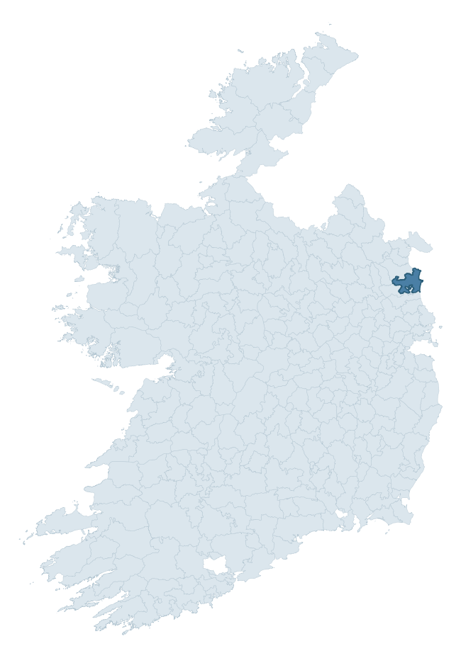
Where this barony sits in the Republic of Ireland
Geology and preservation
Bedrock geology shapes the landscape long before any settlement begins — controlling soil drainage, agricultural potential, the survival of upstanding monuments, and the preservation of buried archaeology. The figures below come from the Geological Survey Ireland 1:100,000 bedrock map.
The bedrock underlying Ferrard is predominantly calcareous greywacke (27% of the barony by area), laid down during the Silurian period (76% by area, around 444 to 419 million years ago). A substantial secondary geology of mudstone and sandstone (23%) and greywacke and mudstone (16%) adds further variety to the underlying landscape. The single largest mapped unit is the Clogherhead Formation (27% of the barony's bedrock). With 10 distinct rock types mapped, the barony sits in the top third of ROI baronies for geological diversity (91st percentile) — typically a sign of complex tectonic history or coastal mosaics of differing rock units.
Rock type composition
Largest mapped unit: Clogherhead Formation (27% of the barony)
Placename evidence
Logainm records 23 heritage-diagnostic placenames for Ferrard, drawn from townland and civil-parish names across the barony. The dominant stratum is pre-Christian and Early Medieval defensive — ráth-, lios-, dún-, and caiseal-prefixed names that mark Iron Age and early historic settlement. The leading diagnostic roots are ráth- (7 — earthen ringfort), dún- (4 — hilltop fort or promontory fort), and cill- (3 — church). This is below the ROI average of 30.7 heritage placenames per barony, suggesting either lighter survey coverage or a townland-naming tradition that draws more on generic landscape vocabulary. The presence of multiple heritage strata side by side indicates layered occupation of the landscape across successive prehistoric and historic periods. Logainm records 173 placenames for Ferrard (predominantly townland names). Of these, 23 (13%) carry one of the diagnostic Gaelic roots tracked above; the remainder draw on more generic landscape vocabulary that does not encode a heritage period.
Pre-Christian / Early Medieval Defensive
| Root | Count | Meaning |
|---|---|---|
| ráth- | 7 | earthen ringfort |
| dún- | 4 | hilltop or promontory fort |
| lios- | 1 | ringfort or enclosure |
Early Christian Ecclesiastical
| Root | Count | Meaning |
|---|---|---|
| cill- | 3 | church (early) |
| mainistir- | 3 | monastery |
| gráinseach- | 3 | monastic farm / grange |
| díseart- | 2 | hermitage |
Burial, Ritual, and Norse-Contact
| Root | Count | Meaning |
|---|---|---|
| gall- | 2 | foreigner — Norse settlement marker |
Other baronies in Louth
About this profile
Click any section below to expand.
What is a barony?
A barony is a historic administrative unit in Ireland, broadly equivalent to an English hundred. The 280 baronies used here are from the OSi 2019 National Statutory Boundaries (generalised 20m), covering the 26 counties of the Republic of Ireland. Baronies derive from the Norman period, were formalised in the 17th century, and have not been redrawn for statistical purposes. They vary enormously in area, from compact urban baronies in Dublin to vast upland baronies in Connacht, and should not be compared by raw site count without accounting for area differences.
What counts as a site?
This profile combines three distinct heritage registers, each with its own definition of what constitutes a recordable site:
- Archaeological sites (NMS). The National Monuments Service Sites and Monuments Record (SMR) catalogues every known archaeological monument or site of archaeological interest in the Republic, from prehistoric burial mounds and ringforts to medieval churches and post-medieval defensive works. Inclusion does not require legal protection — only that the site has been identified, surveyed, and assessed as having archaeological value. A separate subset of these sites lies within a recorded protection zone, which gives them statutory protection under the National Monuments Acts.
- Listed buildings (NIAH). The National Inventory of Architectural Heritage records buildings of architectural, historical, archaeological, artistic, cultural, scientific, social, or technical interest. Each surveyed structure is appraised on a five-tier scale: International, National, Regional, Local, and Record-Only. The NIAH appraisal is informational rather than strictly statutory, but it underpins local-authority Record of Protected Structures (RPS) listings.
- Heritage placenames (Logainm). Logainm is the authoritative database of Irish placenames maintained by the Placenames Branch. This profile applies a heritage-diagnostic classifier to the Irish-language form of each townland name, flagging roots that signal defensive sites (ráth-, lios-, dún-, caiseal-, cathair-), ecclesiastical foundations (cill-, teampall-, domhnach-, mainistir-), prehistoric burial-ritual features (tuaim-, carn-, leaba-), or Norse-contact settlement (gall-). Townlands without one of these diagnostic roots are not flagged here — they may still carry historical significance, but that significance is not encoded in the name itself.
Editorial principles
The narrative sections of this profile follow several explicit principles:
- Evidential. Every claim about this barony’s heritage character is anchored in the underlying register data. Where a site count, a placename count, or a percentile rank is cited, it is computed from the source datasets at export time, not estimated.
- Comparative. Counts and metrics are reported alongside their percentile rank against the other 279 ROI baronies. A barony with 50 ringforts in absolute terms could be unusually high or unusually low depending on its size and regional context; percentile ranking removes that ambiguity.
- Transparent on limits. Where a register has known coverage gaps, survey biases, or data-quality issues that affect this barony’s figures, the profile flags them rather than presenting the numbers as definitive.
- No interpretation beyond what the data supports. The narrative does not speculate about historical events, social dynamics, or cultural meaning beyond what the recorded heritage and placename evidence directly attests.
Data caveats and limits
- NMS Sites and Monuments Record is the product of survey campaigns conducted at different intensities across different counties and decades. Some baronies have been surveyed more thoroughly than others, and absolute counts should be read in that light. Sites destroyed by development before survey are typically not represented; sites in heavily forested or upland terrain are sometimes under-recorded.
- NIAH coverage is broadly complete for the Republic of Ireland but the survey was conducted on a rolling county-by-county basis, and the most recent appraisal date varies. Buildings demolished or substantially altered after their original survey may still appear in the register; conversely, recent buildings of merit may not yet have been appraised.
- Logainm classification applies a deliberately conservative pattern-matching approach to the Irish-language townland forms. The classifier prioritises true positives over recall: a townland may carry a heritage signal that the classifier doesn’t recognise, particularly where the diagnostic root has been heavily anglicised or where the townland name draws on a less common term. The 60,000+ townland records and ~9,800 classified placenames give a substantial signal at barony scale, but individual townland names should be checked against Logainm directly for definitive interpretation.
- Period attribution. The chronological distribution reflects only those NMS sites that carry a recognised period attribution in the source data. Sites listed as “Unknown” period are excluded from the dated subset.
- Boundary changes. Some baronies have undergone minor boundary adjustments since their 19th-century definition; the OSi 2019 generalised boundaries used here are the current statutory definition and may differ slightly from historical maps in border areas.
- Bedrock geology is mapped at 1:100,000 scale, which means local variation within a barony — small pockets of different rock type, mineral veins, alluvium overlying bedrock — is generalised. The dominant-system and rocktype figures are area-weighted, so a barony reading “70% Carboniferous limestone” may still contain small but archaeologically important pockets of older or younger rock. Around 3% of GSI polygons do not match the lexicon and contribute no rocktype or system attribution.
Data sources
- National Monuments Service — Sites and Monuments Record (SMR) https://data.gov.ie/dataset/national-monuments-service-archaeological-survey-of-ireland
- National Inventory of Architectural Heritage (NIAH) https://data.gov.ie/dataset/national-inventory-of-architectural-heritage-niah-national-dataset
- Logainm — Placenames Database of Ireland https://www.logainm.ie/
- Ordnance Survey Ireland — National Statutory Barony Boundaries 2019 https://data-osi.opendata.arcgis.com/
- EURODEM — European Digital Elevation Model https://www.mapsforeurope.org/datasets/euro-dem
- ESA WorldCover https://esa-worldcover.org/en
- Geological Survey Ireland — 1:100,000 Bedrock Geology https://www.gsi.ie/en-ie/data-and-maps/Pages/Bedrock.aspx
Explore more: Search any of the 280 ROI baronies, browse by historical province, or read the methodology and data sources for the full Republic of Ireland Heritage Tool.