
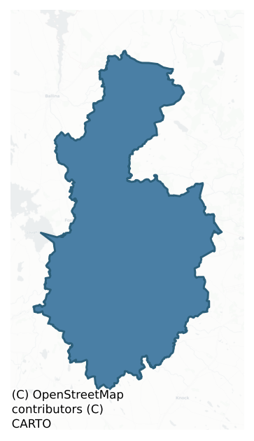
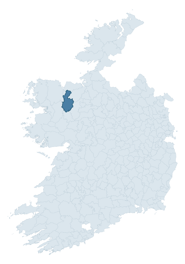
Gallen is a barony of County Mayo, in the historical province of Connacht (Irish: Gaileanga), covering 483 km² of land. The barony records 1,487 NMS archaeological sites and 110 NIAH listed buildings, placing it at around the 83rd percentile among 280 ROI baronies for sites per km². This means it is in the top fifth of all baronies for sites per km². Dated archaeological evidence runs from the Neolithic through to the Modern, spanning 8 of 9 archaeological periods, placing the barony in the 52nd percentile among 280 ROI baronies for chronological depth. This means it is in the upper half of all baronies for chronological depth. The largest dated subset of recorded sites dates to the Early Medieval. Logainm flags 62 placenames in the barony as carrying a recognised heritage root; the largest share — around 56% — are names associated with pre-christian defensive.
Heritage at a glance
Percentile rankings throughout this profile compare each barony only against the other 279 Republic of Ireland baronies.
The recorded heritage of Gallen
The National Monuments Service Sites and Monuments Record (SMR) is the statutory inventory of archaeological sites for the Republic of Ireland, maintained by the Department of Tourism, Culture, Arts, Gaeltacht, Sport and Media. Sites recorded here include earthworks, ringforts, megalithic tombs, ecclesiastical remains, and post-medieval features; not every record is legally protected, but each is registered as a monument of archaeological interest.
The National Monuments Service records 1,487 archaeological sites in Gallen, putting it at the 83rd percentile among 280 ROI baronies for sites per km². This means it is in the top fifth of all baronies for sites per km². Protection coverage is near-universal — 1,476 sites (99%) fall within a recorded monument protection zone, indicating an extensively surveyed landscape. The dominant category is defensive sites — ringforts, enclosures, hillforts, and stone forts (1,042 sites, 70% of the record). Ringfort – rath is the most prevalent type, making up 29% of the barony's recorded sites (430 records) — well above the ROI average of 20% across all baronies where this type occurs. Ringfort – rath is an earthen ringfort enclosed by a bank and external ditch — the most common Early Medieval farmstead, broadly dated 500–1000 AD. Other significant types include Enclosure (279) and Souterrain (170). Enclosure is a banked or ditched feature of uncertain type, used as a catch-all where the original function cannot be determined from surface evidence; Souterrain is an underground stone-built passage and chamber, generally Early Medieval and often associated with ringforts as a defensive or storage feature. Across the barony's 483 km², this gives a recorded density of 3.08 sites per km².
Most common monument types
Hover or tap a monument type to see its definition.
| Type | Count |
|---|---|
| Ringfort – rath an earthen ringfort enclosed by a bank and external ditch — the most common Early Medieval farmstead, broadly dated 500–1000 AD | 430 |
| Enclosure a banked or ditched feature of uncertain type, used as a catch-all where the original function cannot be determined from surface evidence | 279 |
| Souterrain an underground stone-built passage and chamber, generally Early Medieval and often associated with ringforts as a defensive or storage feature | 170 |
| Ringfort – cashel the stone-walled equivalent of the rath, found mainly in upland or western areas, broadly dated 500–1000 AD | 83 |
| Fulacht fia a horseshoe-shaped Bronze Age burnt mound built around a sunken trough beside a water source, traditionally interpreted as a cooking site | 53 |
| House – indeterminate date a habitation building whose date cannot be determined from available evidence | 51 |
| Standing stone a deliberately set upright stone, used variously as a Bronze/Iron Age burial marker, route marker or commemorative monument | 28 |
| Ringfort – unclassified a circular Early Medieval settlement enclosure where surviving evidence does not allow distinction between earthen and stone forms | 28 |
Chronological distribution
The dated archaeological record for Gallen spans from the Neolithic through to the Modern, with activity attested across 8 of 9 archaeological periods. Every period from earliest to latest is represented in the record — an unbroken sequence of dated activity across the full chronological span. Activity concentrates most heavily in the Early Medieval (734 sites, 56% of dated material), with the Iron Age forming a secondary peak (349 sites, 27%). A further 181 recorded sites (12% of the overall NMS register for the barony) carry no period attribution — appearing as 'Unknown' in the bar chart below. This typically reflects either records that pre-date the standardised period vocabulary or sites awaiting specialist dating review, rather than a genuine absence of chronological evidence.
Sample of recorded monuments
Show 25 sample monuments (of 1,487 total)
A representative sample of 25 recorded monuments drawn from the barony’s 1,487 total NMS entries. Sites within a recorded monument protection zone and rarer site types are prioritised so the list shows a meaningful cross-section rather than only the most common type. Each entry shows the official Sites and Monuments Record reference number and the description published by the National Monuments Service.
Field system
In an area of cutaway blanket bog, located on the SW-facing slope of a low knoll, on the lower west-facing slopes of the Ox Mountains.
This prehistoric field system is associated with a large, stone-walled enclosure…
In an area of cutaway blanket bog, located on the SW-facing slope of a low knoll, on the lower west-facing slopes of the Ox Mountains.
This prehistoric field system is associated with a large, stone-walled enclosure (MA031-049001-), a hut site (MA031-049003-) and extensive areas of cultivation ridges (MA031-049004-), all of which underlay c. 0.7m of peat. They were investigated over several seasons in a combined programme of survey and excavation (E000769) during the 1970's and 1980's (Herity 1981). It was not possible to plot the full extent of the field system, but several drystone walls were uncovered by excavation or traced by probing beneath the peat. A charcoal sample from beneath the wall of the enclosure yielded a Bronze Age date. The earliest walls were constructed directly on mineral soils, but later walls were built on peat, indicating that farming activity continued here for a considerable time as the spread of peat slowly advanced. Analysis of pollen cores suggest that there were successive phases of clearance and farming activity over the course of several centuries from the Bronze Age into the Iron Age, before the area was finally engulfed in blanket bog (O’Connell 1990, 261-70).
Compiled by: Jane O'Shaughnessy
Date of upload: 19 June 2018
Megalithic tomb – passage tomb
In lowlying, level pasture, 3m S of a stream, and 120m E of the confluence of the stream with the Fiddaun River. There are good, but not extensive views of the surrounding countryside, with the Ox Mountains defining the…
In lowlying, level pasture, 3m S of a stream, and 120m E of the confluence of the stream with the Fiddaun River. There are good, but not extensive views of the surrounding countryside, with the Ox Mountains defining the skyline to SE.
This passage tomb not shown on the 1837-8 OS 6-inch map, but is shown on the 1922 edition. It was recorded by Herity (1974, 280) as follows: ‘On a low gravel hillock, immediately south of a stream on the west side of the Ox Mountains and 10km south of the Carrowhubbock tombs (SL1, 2), stands a ring of large boulders 21m in diameter with a boulder built chamber in the centre. To the east of the chamber are two matched stones, presumably a passage.’
Inspected in 1995, it consists of a circular, flat-topped rise or mound (diam. c. 30-35m) with broadly sloping sides (H 1.7m to S). On top of the mound, set several meters in from the edge, is a circle (diam. c. 16m) of close-set or contiguous boulders, best preserved on the SW arc. There are several gaps or breaks in the circle, the largest being to N and SE. The boulders (H 0.8-1.1m; circ. 2.5-3m) are irregular or rounded in form; some are set in the ground, others appear to merely rest on it. There are a few displaced stones on the N edge of the mound. A number of large stones protrude from a slight depression in the centre of the circle. These may be part of a chamber. A pair of matched stones (L 0.7m; H 0.4m), set 0.8m apart, stands 1m to E and may represent remnants of a passage, aligned E-W…
Holed stone
OPW topographical files (1947) record a rough stone with a perforation (10cm by 5cm; D 7.5cm) close to one edge. Close to the opposite edge was a shallow hollow (diam. 10cm). There was a megalithic structure…
OPW topographical files (1947) record a rough stone with a perforation (10cm by 5cm; D 7.5cm) close to one edge. Close to the opposite edge was a shallow hollow (diam. 10cm). There was a megalithic structure (MA040-063002-) 6.7m to S and a standing stone (MA040-063003-) 2.4m S of the latter. All three features were removed from their original locations and buried during land reclamation work.
Compiled by: Jane O’Shaughnessy
Date of upload: 8 June 2020
Anomalous stone group
The Archaeological Survey of Ireland (ASI) is in the process of providing information on all monuments on The Historic Environment Viewer (HEV). Currently the information for this record has not been uploaded. To…
The Archaeological Survey of Ireland (ASI) is in the process of providing information on all monuments on The Historic Environment Viewer (HEV). Currently the information for this record has not been uploaded. To access available information for research purposes please make an appointment in advance with the Archive Unit (open Fridays 10.00 am – 5.00 pm), Department of Culture, Heritage and the Gaeltacht, The Custom House, Dublin 1 D01W6XO or email nmarchive@chg.gov.ie.
Megalithic tomb – portal tomb
The Archaeological Survey of Ireland (ASI) is in the process of providing information on all monuments on The Historic Environment Viewer (HEV). Currently the information for this record has not been uploaded. To…
The Archaeological Survey of Ireland (ASI) is in the process of providing information on all monuments on The Historic Environment Viewer (HEV). Currently the information for this record has not been uploaded. To access available information for research purposes please make an appointment in advance with the Archive Unit (open Fridays 10.00 am – 5.00 pm), Department of Culture, Heritage and the Gaeltacht, The Custom House, Dublin 1 D01W6XO or email nmarchive@chg.gov.ie.
Stone circle
The Archaeological Survey of Ireland (ASI) is in the process of providing information on all monuments on The Historic Environment Viewer (HEV). Currently the information for this record has not been uploaded. To…
The Archaeological Survey of Ireland (ASI) is in the process of providing information on all monuments on The Historic Environment Viewer (HEV). Currently the information for this record has not been uploaded. To access available information for research purposes please make an appointment in advance with the Archive Unit (open Fridays 10.00 am – 5.00 pm), Department of Culture, Heritage and the Gaeltacht, The Custom House, Dublin 1 D01W6XO or email nmarchive@chg.gov.ie.
Metalworking site
The Archaeological Survey of Ireland (ASI) is in the process of providing information on all monuments on The Historic Environment Viewer (HEV). Currently the information for this record has not been uploaded. To…
The Archaeological Survey of Ireland (ASI) is in the process of providing information on all monuments on The Historic Environment Viewer (HEV). Currently the information for this record has not been uploaded. To access available information for research purposes please make an appointment in advance with the Archive Unit (open Fridays 10.00 am – 5.00 pm), Department of Culture, Heritage and the Gaeltacht, The Custom House, Dublin 1 D01W6XO or email nmarchive@chg.gov.ie.
Barracks
The Archaeological Survey of Ireland (ASI) is in the process of providing information on all monuments on The Historic Environment Viewer (HEV). Currently the information for this record has not been uploaded. To…
The Archaeological Survey of Ireland (ASI) is in the process of providing information on all monuments on The Historic Environment Viewer (HEV). Currently the information for this record has not been uploaded. To access available information for research purposes please make an appointment in advance with the Archive Unit (open Fridays 10.00 am – 5.00 pm), Department of Culture, Heritage and the Gaeltacht, The Custom House, Dublin 1 D01W6XO or email nmarchive@chg.gov.ie.
Cross (present location)
The Archaeological Survey of Ireland (ASI) is in the process of providing information on all monuments on The Historic Environment Viewer (HEV). Currently the information for this record has not been uploaded. To…
The Archaeological Survey of Ireland (ASI) is in the process of providing information on all monuments on The Historic Environment Viewer (HEV). Currently the information for this record has not been uploaded. To access available information for research purposes please make an appointment in advance with the Archive Unit (open Fridays 10.00 am – 5.00 pm), Department of Culture, Heritage and the Gaeltacht, The Custom House, Dublin 1 D01W6XO or email nmarchive@chg.gov.ie.
Sundial
The Archaeological Survey of Ireland (ASI) is in the process of providing information on all monuments on The Historic Environment Viewer (HEV). Currently the information for this record has not been uploaded. To…
The Archaeological Survey of Ireland (ASI) is in the process of providing information on all monuments on The Historic Environment Viewer (HEV). Currently the information for this record has not been uploaded. To access available information for research purposes please make an appointment in advance with the Archive Unit (open Fridays 10.00 am – 5.00 pm), Department of Culture, Heritage and the Gaeltacht, The Custom House, Dublin 1 D01W6XO or email nmarchive@chg.gov.ie.
Ecclesiastical enclosure
The Archaeological Survey of Ireland (ASI) is in the process of providing information on all monuments on The Historic Environment Viewer (HEV). Currently the information for this record has not been uploaded. To…
The Archaeological Survey of Ireland (ASI) is in the process of providing information on all monuments on The Historic Environment Viewer (HEV). Currently the information for this record has not been uploaded. To access available information for research purposes please make an appointment in advance with the Archive Unit (open Fridays 10.00 am – 5.00 pm), Department of Culture, Heritage and the Gaeltacht, The Custom House, Dublin 1 D01W6XO or email nmarchive@chg.gov.ie.
Bridge
The Archaeological Survey of Ireland (ASI) is in the process of providing information on all monuments on The Historic Environment Viewer (HEV). Currently the information for this record has not been uploaded. To…
The Archaeological Survey of Ireland (ASI) is in the process of providing information on all monuments on The Historic Environment Viewer (HEV). Currently the information for this record has not been uploaded. To access available information for research purposes please make an appointment in advance with the Archive Unit (open Fridays 10.00 am – 5.00 pm), Department of Culture, Heritage and the Gaeltacht, The Custom House, Dublin 1 D01W6XO or email nmarchive@chg.gov.ie.
Castle – Anglo-Norman masonry castle
Strategically sited on a low but prominent rocky outcrop merging at E with rising ground, adjacent to a fording point on the River Moy which is 300m to N. It overlooks an expanse of lowlying ground at SE−W, through…
Strategically sited on a low but prominent rocky outcrop merging at E with rising ground, adjacent to a fording point on the River Moy which is 300m to N. It overlooks an expanse of lowlying ground at SE−W, through which a tributary stream flows NW to join the Moy.
This 13th-century Anglo-Norman castle is a National Monument in state guardianship (no. 325).
It was built in the late 1230’s/early 1240’s by Jordan de Exeter, who participated in the Anglo-Norman conquest of Connacht and thus came into possession of the cantred or barony of Gallen. De Exeter was appointed Sheriff of Connaught in the late 1240’s and led several campaigns to subdue the Gaelic clans and consolidate Anglo-Norman power in Connacht; he was killed in battle in 1258. Over the succeeding centuries, as Anglo-Norman control slipped, de Exeter’s descendants were subsumed into Gaelic culture, and the family adopting the name Mac Síurtáin (Mac Jordan, later simply Jordan).
De Exeter constructed Ballylahan castle as a stronghold on an important routeway and fording point -the townland name derives from ‘Baile-Atha-lethain’ or ‘Town of the Broad Ford’. The initial settlement saw the establishment of a town (MA061-145002-) in association with the castle, of which no trace survives, and de Exeter also founded nearby Strade Abbey (MA070-067001-).
The castle was attacked in 1316 by Fedhlim O’Conchobhair (Felim McHugh O’Connor), King of Connacht (MA061-227—-). An account of this event in the Annals of Loch C…
Settlement deserted – medieval
This record refers to a market town or settlement which was established in the vicinity of Ballylahan Castle (MA061-145001-), an Anglo-Norman fortification built in the mid-late 13th century by Jordan de Exeter at a…
This record refers to a market town or settlement which was established in the vicinity of Ballylahan Castle (MA061-145001-), an Anglo-Norman fortification built in the mid-late 13th century by Jordan de Exeter at a fording point on the River Moy (Knox 1908, 108). The townland name derives from the Irish ‘Baile-Atha-lethain’ or ‘Town of the Broad Ford’. No trace now survives of a town, and it has not been possible to establish its exact location, extent or nature.
Compiled by: Jane O’Shaughnessy
Date of upload: 6 January 2022
Bawn
The Archaeological Survey of Ireland (ASI) is in the process of providing information on all monuments on The Historic Environment Viewer (HEV). Currently the information for this record has not been uploaded. To…
The Archaeological Survey of Ireland (ASI) is in the process of providing information on all monuments on The Historic Environment Viewer (HEV). Currently the information for this record has not been uploaded. To access available information for research purposes please make an appointment in advance with the Archive Unit (open Fridays 10.00 am – 5.00 pm), Department of Culture, Heritage and the Gaeltacht, The Custom House, Dublin 1 D01W6XO or email nmarchive@chg.gov.ie.
Tomb – unclassified
The Archaeological Survey of Ireland (ASI) is in the process of providing information on all monuments on The Historic Environment Viewer (HEV). Currently the information for this record has not been uploaded. To…
The Archaeological Survey of Ireland (ASI) is in the process of providing information on all monuments on The Historic Environment Viewer (HEV). Currently the information for this record has not been uploaded. To access available information for research purposes please make an appointment in advance with the Archive Unit (open Fridays 10.00 am – 5.00 pm), Department of Culture, Heritage and the Gaeltacht, The Custom House, Dublin 1 D01W6XO or email nmarchive@chg.gov.ie.
Religious house – Dominican friars
Strade Dominican friary is a National Monument in state ownership (no. 172). It is located in the parish of Templemore, in the N end of Strade townland, a few kilometres SE of Lough Cullin in central Co. Mayo.
A…
Strade Dominican friary is a National Monument in state ownership (no. 172). It is located in the parish of Templemore, in the N end of Strade townland, a few kilometres SE of Lough Cullin in central Co. Mayo.
A friary for the Franciscan Order was established in Strade in the early to mid-1200’s -the exact date is unknown- by Jordan de Exeter, Lord of Athlethan. He also built a castle (MA061-145—- ) and established the borough of Athlethan (now Ballylahan townland), c. 2.5km NW of the friary (Knox 1903, 406). The Franciscans did not, however, remain long at Strade. In 1253, the friary was transferred to Dominican friars, either by Jordan or by his son, Stephen fitz Jordan de Exeter. This is said to have been done at the request of Stephen’s wife, Basilia, daughter of Myler de Bermingham, who was patron of the Dominicans at Athenry. Basilia is said to have invited her father to Strade for a feast at which she declared she would neither eat nor drink until her husband agreed to expel the Franciscans from Strade in favour of the Dominicans (Coleman 1912, 204-5). Papal permission was subsequently sought and received for the transfer, aided by the incentive of a sizable donation.
The Dominican priory was dedicated to the Holy Cross and, according to the 16th-century Register of the Priory of Athenry, was a daughter house of Sligo Dominican priory (SL014-068008-) (Swords 1998, 21). Soon after they took possession, the Dominican suffered a misfortune: The Annals of Loch Cé r…
Wall monument
Located in the N wall of the chancel in the church of the Dominican priory (MA070-067001-) of Strade.
This 15th-century canopy tomb/wall monument is one of the finest surviving examples of its type in Ireland. It…
Located in the N wall of the chancel in the church of the Dominican priory (MA070-067001-) of Strade.
This 15th-century canopy tomb/wall monument is one of the finest surviving examples of its type in Ireland. It features a pointed arch filled with gloriously flamboyant, flowing cusped tracery. The hood-moulding of the arch is decorated with eleven crockets on each side and at the apex, which is crowned by a cross-shaped finial, and it is framed by two chamfered pinnacles terminating into crocketted finials. At the base of the arch on the W side is a carving of a dog, a symbol of loyalty and faithfulness.
The front of the mensa or tomb is comprised of two panels, each decorated with four figures carved within their own small ogee-headed canopy with pinnacles. In the left-hand panel, each ogee-headed canopy is separated by a slim pilaster. A broader pilaster separates this panel from the right-hand panel, where each canopy is supported by an angel.
The eight figures are finely carved, with great attention to details such as hair and facial features, the folds of the clothing and the symbolic attributes each displays or carries. The four crowned figures on the W panel (from L) represent the three Magi, carrying their gifts of gold, frankincense and myrrh in ciborium-like containers, and Christ displaying the Five Wounds. The four figures on the right-hand panel (from L) include a kneeling man, a bishop wearing a mitre, one hand raised in blessing and the other carrying a…
Religious house – Franciscan friars
This record was listed in the SMR (1991) and RMP (1996) as 'Friary'. It relates to an OS mapping error which identifies an 'Abbey (Site of)'. This refers to the establishment of a Franciscan friary in the 13th century…
This record was listed in the SMR (1991) and RMP (1996) as 'Friary'. It relates to an OS mapping error which identifies an 'Abbey (Site of)'. This refers to the establishment of a Franciscan friary in the 13th century which was subsequently transferred to the Dominican friars (MA070-067001-) in 1252-3. In essence, this is a duplicate record.
Compiled by: Paul Walsh
Date of upload: 17 November 2014
Chapel
Within a rath (MA071-027002-).
A rectangular building (c. 14m NE−SW; 6-7m NW−SE), annotated ‘Chapel (in ruins)’, is indicated in the centre of the rath on the 1838 OS 6-inch map; the building is not shown on the 1931…
Within a rath (MA071-027002-).
A rectangular building (c. 14m NE−SW; 6-7m NW−SE), annotated ‘Chapel (in ruins)’, is indicated in the centre of the rath on the 1838 OS 6-inch map; the building is not shown on the 1931 edition, where the location is marked ‘Chapel (site of)’. No remains of the chapel are visible at ground level.
Compiled by: Jane O’Shaughnessy
Date of upload: 2 July 2021
Enclosure – large enclosure
In pasture, encompassing gently elevated ground. The outline of a possible polygonal or subcircular enclosure (diam. c. 250m NW−SE) is defined in a rough arc at SE−N by a series of straight and gently curving field…
In pasture, encompassing gently elevated ground. The outline of a possible polygonal or subcircular enclosure (diam. c. 250m NW−SE) is defined in a rough arc at SE−N by a series of straight and gently curving field fences and field drains. A field drain defines the straight E side. The outline is visible on the 1931 OS 6-inch map and in current aerial imagery. There is no definitive evidence that the field banks and drains are ancient.
Compiled by: Jane O’Shaughnessy
Date of upload: 2 July 2021
Round tower
In the SW quadrant of a graveyard (MA071-028002-), located on the top of a low hill. The location provides good views over an expanse of flat, damp pastureland which surrounds the base of the hill, and of the…
In the SW quadrant of a graveyard (MA071-028002-), located on the top of a low hill. The location provides good views over an expanse of flat, damp pastureland which surrounds the base of the hill, and of the surrounding low hills beyond.
This round tower is a National Monument in State care (No. 98). The circular tower (diam. c. 5.5m) is well built of relatively uniformly-sized, evenly-coursed sandstone blocks, and some limestone, dressed to the curve. It stands to a height of c. 21m, but is missing its original conical cap. There is an offset (Wth 0.16-0.25m; H 0.16-0.25m) around the circumference at the base. This is lowest at S−SW, but is higher on the N and E sides where it helps compensate for a natural drop in ground level. At N−NE and t SE the offset has a double step (total H 0.6m), with the lower level built of rougher, larger stones. A thin, shallow groove is incised on the upper surface of the stones of the offset, describing a continuous circle around the circumference. This may have provided a guideline for the construction of the tower on these foundations. The tower has a round-headed, externally splayed doorway (H 1.68m; Wth 0.76m; D 1.1m) at SSE. It is set above ground level, as is usual in round towers, in this case, 3.42m above the top external offset. It has a mortice for a bolt on the inside of the E jamb (Barrow 1979, 159). The tower had at least four floors levels, lit by small windows, flat-headed at NNW, WSW, ESE, and N, and angle-headed (created…
Habitation site
In pasture, on slightly elevated ground. According to local information, traces of possible houses and hearths and a possible burial (MA072-097002-) were uncovered here. No visible trace at ground level.
Compiled…
In pasture, on slightly elevated ground. According to local information, traces of possible houses and hearths and a possible burial (MA072-097002-) were uncovered here. No visible trace at ground level.
Compiled by: Jane O’Shaughnessy
Date of upload: 21 May 2021
Architectural feature
Located in a graveyard (MA071-142002-), to SW of a medieval church (MA071-142001-).
This architectural fragment was discovered in 2009 during a survey of the graveyard (Burke 2009). It consists of a carved block of…
Located in a graveyard (MA071-142002-), to SW of a medieval church (MA071-142001-).
This architectural fragment was discovered in 2009 during a survey of the graveyard (Burke 2009). It consists of a carved block of sandstone (H 0.4m; Wth 0.2m; T 0.15m) which has been reused as a gravemarker and is set upright in the ground. A human head is carved in false relief across an angle of the square block so that it spans the width of two sides of the stone. The strong, austere face is oblong in shape, flat at the top of the head, with a robust, rounded chin. The facial features are simple but well defined: round eyes, a large, straight nose flaring slightly at the nostrils, and a horizontal groove for the mouth, with well-shaped ears flanking the top of the head. Vertical rows of small decorative bosses are carved into the sides of the stone on either side of the head. The stone was originally a capital of a Romanesque doorway and suggests a 12th-century date for the now ruined church (pers. comm. Con Manning, March 2009).
Compiled by: Jane O’Shaughnessy
Date of upload: 13 September 2021
Ringfort – rath
Located on a ridge overlooking a stream 80m to S.
This rath was fully excavated (92E0152) in 1992-3 in advance of the construction of the N5 Swinford by-pass (Walsh 1995, 7-8). Prior to excavation, the rath was…
Located on a ridge overlooking a stream 80m to S.
This rath was fully excavated (92E0152) in 1992-3 in advance of the construction of the N5 Swinford by-pass (Walsh 1995, 7-8). Prior to excavation, the rath was evident as an oval area (35m N−S; 30m E−W) defined by an earthen bank. The bank was levelled in the 1970’s and very little of it remained. Excavation revealed that the bank had an external fosse (Wth 2.9-4.7m at top; D 1.1-1.8m). The foundations of three circular structures (int. diam. 3.6-4.6m), interpreted as houses (MA071-042001-; MA071-042002-; MA071-042003-), were uncovered in the W half of the interior. An iron-smelting pit-furnace (MA071-0142004-) was found in the S half of the rath interior, with associated finds of furnace bottoms and smelted, unforged iron. Artefacts recovered included iron nails, hooks and a knife, a bronze stick pin, a fragment of a polished lignite bracelet, a stone bead and a yellow glass bead, and an assemblage of flint and chert implements. Animal bones were also recovered.
While many of the artefacts fit comfortably in the early medieval era, the charcoal samples taken from the house foundation trenches produced radiocarbon dates placed firmly in the Iron Age period:
House 1 191 cal. BC–cal. AD 2
House 2 200 cal. BC–cal. AD 140
House 3 192 cal. BC–cal. AD 58
(Walsh, G. 1995)
Compiled by: Jane O’Shaughnessy
Date of upload: 13 July 2021
Listed buildings
The National Inventory of Architectural Heritage (NIAH) is a state survey appraising buildings of architectural, historical, archaeological, artistic, cultural, scientific, social, or technical interest. Each surveyed structure receives a rating from International (the highest, for buildings of European importance) through National, Regional, Local, and Record-Only.
The NIAH records 110 listed buildings in Gallen (53rd percentile across ROI baronies). All recorded buildings carry Regional or lower grading; the barony does not contain any structures appraised as being of National or International architectural importance. Construction dates concentrate most heavily in the Victorian (1830-1900) period. The most-recorded building type is bridge (26 examples, 24% of the listed stock).
Terrain and environment
Mean elevation across the barony is 78m — the 39th percentile among 280 ROI baronies for elevation. This means it is in the lower half of all baronies for elevation. Elevation matters for heritage because higher-altitude baronies typically favour defensive monuments — ringforts and hilltop forts placed on prominent ground — while lowland baronies are more likely to carry the dense settlement and church networks of intensive agricultural landscapes. The barony reaches 405m at its highest point — a vertical span of more than 327m within its boundary, indicating significant topographic diversity. Mean slope is 4.2° — the 62nd percentile among 280 ROI baronies for slope. This means it is in the upper half of all baronies for slope. Slope is a key control on both land use and archaeological preservation: steep ground resists ploughing and tends to preserve earthworks intact, while gentle slopes favour intensive cultivation that damages or destroys surface archaeology over time. The Topographic Wetness Index averages 10.6, the 41st percentile among 280 ROI baronies for wetness. This means it is in the lower half of all baronies for wetness. Drainage matters for heritage because poorly-drained ground preserves organic archaeology (wooden trackways, leather, textiles, and on rare occasions human remains) far better than free-draining soil; well-drained ground favours arable use but destroys organic material rapidly. The land cover is dominated by improved grassland (79%) and woodland (19%).
Terrain measurements
Where this barony sits in the Republic of Ireland
Geology and preservation
Bedrock geology shapes the landscape long before any settlement begins — controlling soil drainage, agricultural potential, the survival of upstanding monuments, and the preservation of buried archaeology. The figures below come from the Geological Survey Ireland 1:100,000 bedrock map.
The bedrock underlying Gallen is predominantly limestone and shale (26% of the barony by area), laid down during the Carboniferous period (71% by area, around 359 to 299 million years ago). With 14 distinct rock types mapped, the barony sits in the top third of ROI baronies for geological diversity (97th percentile) — typically a sign of complex tectonic history or coastal mosaics of differing rock units.
Rock type composition
Largest mapped unit: Aille Limestone Formation (13% of the barony)
Placename evidence
Logainm records 62 heritage-diagnostic placenames for Gallen, drawn from townland and civil-parish names across the barony. The dominant stratum is pre-Christian and Early Medieval defensive — ráth-, lios-, dún-, and caiseal-prefixed names that mark Iron Age and early historic settlement. The leading diagnostic roots are lios- (18 — ringfort or enclosure), cill- (14 — church), and ráth- (9 — earthen ringfort). This is well above the ROI average of 30.7 heritage placenames per barony — around 2.0× the typical figure. The presence of multiple heritage strata side by side indicates layered occupation of the landscape across successive prehistoric and historic periods. Logainm records 302 placenames for Gallen (predominantly townland names). Of these, 62 (21%) carry one of the diagnostic Gaelic roots tracked above; the remainder draw on more generic landscape vocabulary that does not encode a heritage period.
Pre-Christian / Early Medieval Defensive
| Root | Count | Meaning |
|---|---|---|
| lios- | 18 | ringfort or enclosure |
| ráth- | 9 | earthen ringfort |
| caiseal- | 5 | stone ringfort |
| dún- | 2 | hilltop or promontory fort |
Early Christian Ecclesiastical
| Root | Count | Meaning |
|---|---|---|
| cill- | 14 | church (early) |
| teampall- | 3 | church (later medieval) |
| cillín- | 3 | unconsecrated burial ground |
Burial, Ritual, and Norse-Contact
| Root | Count | Meaning |
|---|---|---|
| tuaim- | 3 | burial mound |
| gall- | 3 | foreigner — Norse settlement marker |
| leacht- | 2 | grave monument |
| carn- | 1 | cairn |
| uaimh- | 1 | cave / souterrain |
Other baronies in Mayo
About this profile
Click any section below to expand.
What is a barony?
A barony is a historic administrative unit in Ireland, broadly equivalent to an English hundred. The 280 baronies used here are from the OSi 2019 National Statutory Boundaries (generalised 20m), covering the 26 counties of the Republic of Ireland. Baronies derive from the Norman period, were formalised in the 17th century, and have not been redrawn for statistical purposes. They vary enormously in area, from compact urban baronies in Dublin to vast upland baronies in Connacht, and should not be compared by raw site count without accounting for area differences.
What counts as a site?
This profile combines three distinct heritage registers, each with its own definition of what constitutes a recordable site:
- Archaeological sites (NMS). The National Monuments Service Sites and Monuments Record (SMR) catalogues every known archaeological monument or site of archaeological interest in the Republic, from prehistoric burial mounds and ringforts to medieval churches and post-medieval defensive works. Inclusion does not require legal protection — only that the site has been identified, surveyed, and assessed as having archaeological value. A separate subset of these sites lies within a recorded protection zone, which gives them statutory protection under the National Monuments Acts.
- Listed buildings (NIAH). The National Inventory of Architectural Heritage records buildings of architectural, historical, archaeological, artistic, cultural, scientific, social, or technical interest. Each surveyed structure is appraised on a five-tier scale: International, National, Regional, Local, and Record-Only. The NIAH appraisal is informational rather than strictly statutory, but it underpins local-authority Record of Protected Structures (RPS) listings.
- Heritage placenames (Logainm). Logainm is the authoritative database of Irish placenames maintained by the Placenames Branch. This profile applies a heritage-diagnostic classifier to the Irish-language form of each townland name, flagging roots that signal defensive sites (ráth-, lios-, dún-, caiseal-, cathair-), ecclesiastical foundations (cill-, teampall-, domhnach-, mainistir-), prehistoric burial-ritual features (tuaim-, carn-, leaba-), or Norse-contact settlement (gall-). Townlands without one of these diagnostic roots are not flagged here — they may still carry historical significance, but that significance is not encoded in the name itself.
Editorial principles
The narrative sections of this profile follow several explicit principles:
- Evidential. Every claim about this barony’s heritage character is anchored in the underlying register data. Where a site count, a placename count, or a percentile rank is cited, it is computed from the source datasets at export time, not estimated.
- Comparative. Counts and metrics are reported alongside their percentile rank against the other 279 ROI baronies. A barony with 50 ringforts in absolute terms could be unusually high or unusually low depending on its size and regional context; percentile ranking removes that ambiguity.
- Transparent on limits. Where a register has known coverage gaps, survey biases, or data-quality issues that affect this barony’s figures, the profile flags them rather than presenting the numbers as definitive.
- No interpretation beyond what the data supports. The narrative does not speculate about historical events, social dynamics, or cultural meaning beyond what the recorded heritage and placename evidence directly attests.
Data caveats and limits
- NMS Sites and Monuments Record is the product of survey campaigns conducted at different intensities across different counties and decades. Some baronies have been surveyed more thoroughly than others, and absolute counts should be read in that light. Sites destroyed by development before survey are typically not represented; sites in heavily forested or upland terrain are sometimes under-recorded.
- NIAH coverage is broadly complete for the Republic of Ireland but the survey was conducted on a rolling county-by-county basis, and the most recent appraisal date varies. Buildings demolished or substantially altered after their original survey may still appear in the register; conversely, recent buildings of merit may not yet have been appraised.
- Logainm classification applies a deliberately conservative pattern-matching approach to the Irish-language townland forms. The classifier prioritises true positives over recall: a townland may carry a heritage signal that the classifier doesn’t recognise, particularly where the diagnostic root has been heavily anglicised or where the townland name draws on a less common term. The 60,000+ townland records and ~9,800 classified placenames give a substantial signal at barony scale, but individual townland names should be checked against Logainm directly for definitive interpretation.
- Period attribution. The chronological distribution reflects only those NMS sites that carry a recognised period attribution in the source data. Sites listed as “Unknown” period are excluded from the dated subset.
- Boundary changes. Some baronies have undergone minor boundary adjustments since their 19th-century definition; the OSi 2019 generalised boundaries used here are the current statutory definition and may differ slightly from historical maps in border areas.
- Bedrock geology is mapped at 1:100,000 scale, which means local variation within a barony — small pockets of different rock type, mineral veins, alluvium overlying bedrock — is generalised. The dominant-system and rocktype figures are area-weighted, so a barony reading “70% Carboniferous limestone” may still contain small but archaeologically important pockets of older or younger rock. Around 3% of GSI polygons do not match the lexicon and contribute no rocktype or system attribution.
Data sources
- National Monuments Service — Sites and Monuments Record (SMR) https://data.gov.ie/dataset/national-monuments-service-archaeological-survey-of-ireland
- National Inventory of Architectural Heritage (NIAH) https://data.gov.ie/dataset/national-inventory-of-architectural-heritage-niah-national-dataset
- Logainm — Placenames Database of Ireland https://www.logainm.ie/
- Ordnance Survey Ireland — National Statutory Barony Boundaries 2019 https://data-osi.opendata.arcgis.com/
- EURODEM — European Digital Elevation Model https://www.mapsforeurope.org/datasets/euro-dem
- ESA WorldCover https://esa-worldcover.org/en
- Geological Survey Ireland — 1:100,000 Bedrock Geology https://www.gsi.ie/en-ie/data-and-maps/Pages/Bedrock.aspx
Explore more: Search any of the 280 ROI baronies, browse by historical province, or read the methodology and data sources for the full Republic of Ireland Heritage Tool.