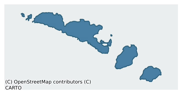
Aran is a barony of County Galway, in the historical province of Connacht (Irish: Árainn), covering 47.4 km² of land. The barony records 569 NMS archaeological sites and 90 NIAH listed buildings, placing it at around the 100th percentile among 280 ROI baronies for sites per km². This means it is in the top tenth of all baronies for sites per km². Dated archaeological evidence runs from the Mesolithic through to the Modern, spanning 9 of 9 archaeological periods, placing the barony in the 91st percentile among 280 ROI baronies for chronological depth. This means it is in the top tenth of all baronies for chronological depth. The largest dated subset of recorded sites dates to the Early Medieval.

Heritage at a glance
Percentile rankings throughout this profile compare each barony only against the other 279 Republic of Ireland baronies.
The recorded heritage of Aran
The National Monuments Service Sites and Monuments Record (SMR) is the statutory inventory of archaeological sites for the Republic of Ireland, maintained by the Department of Tourism, Culture, Arts, Gaeltacht, Sport and Media. Sites recorded here include earthworks, ringforts, megalithic tombs, ecclesiastical remains, and post-medieval features; not every record is legally protected, but each is registered as a monument of archaeological interest.
The National Monuments Service records 569 archaeological sites in Aran, putting it at the 100th percentile among 280 ROI baronies for sites per km². This means it is in the top tenth of all baronies for sites per km². Protection coverage is near-universal — 526 sites (92%) fall within a recorded monument protection zone, indicating an extensively surveyed landscape. The record is dominated by ecclesiastical sites — churches, graveyards, and holy wells (111 sites, 20% of the total), with burial and ritual monuments forming a substantial secondary presence (91 sites, 16%). Mound is the most prevalent type, making up 12% of the barony's recorded sites (67 records) — well above the ROI average of 2% across all baronies where this type occurs. Mound is an artificial earthen elevation of unknown date and function that cannot be classified as another known monument type. Other significant types include Cross-slab (35) and Church (20). Cross-slab is a stone slab inscribed with a cross, used as a grave-marker or memorial, dated pre-1200 AD; Church is a building used for public Christian worship, of any date from c. 500 AD onwards. Across the barony's 47.4 km², this gives a recorded density of 12.01 sites per km².
Most common monument types
Hover or tap a monument type to see its definition.
| Type | Count |
|---|---|
| Mound an artificial earthen elevation of unknown date and function that cannot be classified as another known monument type | 67 |
| Cross-slab a stone slab inscribed with a cross, used as a grave-marker or memorial, dated pre-1200 AD | 35 |
| Church a building used for public Christian worship, of any date from c. 500 AD onwards | 20 |
| Ritual site – holy well a well or spring traditionally associated with a saint, often credited with healing properties; many trace earlier ritual origins but devotion is documented from the medieval period onwards | 17 |
Chronological distribution
The dated archaeological record for Aran spans from the Mesolithic through to the Modern, with activity attested across 9 of 9 archaeological periods. This places Aran in the top 9% of ROI baronies for chronological depth — few baronies record evidence across as many distinct archaeological periods. Every period from earliest to latest is represented in the record — an unbroken sequence of dated activity across the full chronological span. Activity concentrates most heavily in the Early Medieval (96 sites, 40% of dated material), with the Iron Age forming a secondary peak (69 sites, 28%). A further 326 recorded sites (57% of the overall NMS register for the barony) carry no period attribution — appearing as 'Unknown' in the bar chart below. This typically reflects either records that pre-date the standardised period vocabulary or sites awaiting specialist dating review, rather than a genuine absence of chronological evidence.
Sample of recorded monuments
Show 25 sample monuments (of 569 total)
A representative sample of 25 recorded monuments drawn from the barony’s 569 total NMS entries. Sites within a recorded monument protection zone and rarer site types are prioritised so the list shows a meaningful cross-section rather than only the most common type. Each entry shows the official Sites and Monuments Record reference number and the description published by the National Monuments Service.
Cliff-edge fort
Spectacularly perched at the edge of the sheer sea-cliffs on the SW side of Inis Mór, Dún Aonghasa, a multiperiod fort, commands extensive views of the Atlantic seaways off the W coast, as well as across the island…
Spectacularly perched at the edge of the sheer sea-cliffs on the SW side of Inis Mór, Dún Aonghasa, a multiperiod fort, commands extensive views of the Atlantic seaways off the W coast, as well as across the island itself and as far as the Twelve Bens mountain range in Connemara to the N, and the Cliffs of Moher on the Clare coast to the SE. It has been a magnet for antiquarians since the early 19th century and has been studied by Petrie (1972), O'Donovan (O'Flanagan 1927a, Vol. 3, 197-212) and Westropp (1895, 256-9), among others. More recently it was the core focus of 'The Western Stone Forts Project', which was undertaken by the Discovery Programme and during the course of which four seasons of excavations were carried out between 1992 and 1995 (Cotter 2012). The project found that the fort had a long history from its earliest occupation in the Late Bronze Age (c. 1000 BC) to its abandonment in the early medieval period (c. AD 1000).
The initial fort was interpreted by Cotter (ibid., vol. 1, xxiii, Fig. 3.7; vol. 2, 227) to be a hillfort, which was roughly D-shaped in plan (c. 360m NW-SE; c. 240m NE-SW overall) and enclosed an area of 5.8ha (14 acres) (ibid., vol. 1, 53). It was defined by three drystone double-faced limestone walls with rubble cores (av. Wth 2m) that formed an inner (wall 1), middle (wall 2a) and outer enclosure (wall 4) (ibid., vol. 1 55, Fig. 3.7). The U-shaped inner enclosure (c. 51m NW-SE; c. 46m NE-SW) occupied the highest elevation of the pla…
Ritual site – holy tree/bush
Immediately to the NW of St Soorney's Well (GA110-082001-) are two thorn bushes, one of which is revered locally as the saint's bush. Close by to the ESE is a cross-inscribed pillar (GA110-082002-). (Robinson…
Immediately to the NW of St Soorney's Well (GA110-082001-) are two thorn bushes, one of which is revered locally as the saint's bush. Close by to the ESE is a cross-inscribed pillar (GA110-082002-). (Robinson 1980)
Compiled by: Olive Alcock
Date of upload: 29 March 2016
Lighthouse
The Archaeological Survey of Ireland (ASI) is in the process of providing information on all monuments on The Historic Environment Viewer (HEV). Currently the information for this record has not been uploaded. To…
The Archaeological Survey of Ireland (ASI) is in the process of providing information on all monuments on The Historic Environment Viewer (HEV). Currently the information for this record has not been uploaded. To access available information for research purposes please make an appointment in advance with the Archive Unit (open Fridays 10.00 am – 5.00 pm), Department of Culture, Heritage and the Gaeltacht, The Custom House, Dublin 1 D01W6XO or email nmarchive@chg.gov.ie.
Milestone
The Archaeological Survey of Ireland (ASI) is in the process of providing information on all monuments on The Historic Environment Viewer (HEV). Currently the information for this record has not been uploaded. To…
The Archaeological Survey of Ireland (ASI) is in the process of providing information on all monuments on The Historic Environment Viewer (HEV). Currently the information for this record has not been uploaded. To access available information for research purposes please make an appointment in advance with the Archive Unit (open Fridays 10.00 am – 5.00 pm), Department of Culture, Heritage and the Gaeltacht, The Custom House, Dublin 1 D01W6XO or email nmarchive@chg.gov.ie.
Bastioned fort
On the seashore at Cill Éinne, on the site of an earlier castle (GA119-005003-). This National Monument, known locally as Caisleán Aircín, was built c. 1652-5 by Cromwellian forces. A manuscript plan of 1796-8 (Dublin…
On the seashore at Cill Éinne, on the site of an earlier castle (GA119-005003-). This National Monument, known locally as Caisleán Aircín, was built c. 1652-5 by Cromwellian forces. A manuscript plan of 1796-8 (Dublin Oireachtas Libr. MS 8.H.21; pers. comm. P. Kerrigan) shows it as roughly rectangular in plan with two square towers to seaward and two irregularly placed circular towers to landward. Both of the latter and one of the former are now gone. What remains today is a substantial portion of N wall (L c. 63m, H 5m) built on the rocky foreshore. There is a small tower at SE end and a water-gate surmounted by a machicolation further to N. One of the gun and cannon loops incorporates a cross-slab (GA119-005002-) reused as a lintel, giving credence to the tradition that the fort was built of stones from the old monastery (GA119-006006-) nearby. (O'Flanagan 1927a, Vol. 3, 399-400; Robinson 1986, 239-58; Kerrigan 1980, 135; Walsh 1994, 149-58)
The monument was taken into Ownership under the National Monuments Acts 1930 to 2014 – National Monument 43.
The above description is derived from the published 'Archaeological Inventory of County Galway Vol. I – West Galway'. Compiled by Paul Gosling (Dublin: Stationery Office, 1993).
Date of upload: 05 August 2010
GA119-005001-_Arkin Castle_002
GA119-005001-_Arkin Castle_003
GA119-005001-_Arkin Castle_006
Rock scribing – folk art
According to local information, this Galway hooker boat (L of hull c. 1m; H from waterline to top of mast 0.88m), depicted in full sail, was inscribed on the exposed limestone by a schoolboy in the 1940s.
Compiled…
According to local information, this Galway hooker boat (L of hull c. 1m; H from waterline to top of mast 0.88m), depicted in full sail, was inscribed on the exposed limestone by a schoolboy in the 1940s.
Compiled by: Olive Alcock
Date of upload: 23 February 2017
Watchtower
On a height in an area of exposed limestone at the SE end of Árainn/Inishmore, overlooking Gregory’s Sound and Inis Meáin/Inishmaan to the SE. This circular drystone structure (ext. D 4m; H 3m) is built of rough…
On a height in an area of exposed limestone at the SE end of Árainn/Inishmore, overlooking Gregory’s Sound and Inis Meáin/Inishmaan to the SE. This circular drystone structure (ext. D 4m; H 3m) is built of rough limestone blocks and spalls. Two straight lines in the walling at SSW tentatively suggest the presence of a doorway (Wth 0.95m) that was subsequently blocked up. It is reputedly the grave of St Gregory (Westropp 1895, 265). Lennox Barrow (1979, 106) discounted it as a round tower and suggested it was possibly a marker for boats at sea. Its date is uncertain. (Robinson 1980)
Compiled by: Olive Alcock
Date of upload: 26 January 2016
This monument was taken into Ownership under the National Monuments Acts 1930 to 2014 – National Monument 43.
Burial mound
On a sandy rise above the beach close to N shore of the island. This Nat. Mon. is a circular mound revetted by a drystone wall (D 21m, H >1.5m) and it is known locally as Cnoc Raithní (Robinson 1980). Traces of…
On a sandy rise above the beach close to N shore of the island. This Nat. Mon. is a circular mound revetted by a drystone wall (D 21m, H >1.5m) and it is known locally as Cnoc Raithní (Robinson 1980). Traces of slab-lined graves protrude above S half of the flat top of the mound. The N half is occupied by a small rectangular kerbed platform (H 0.9m) surmounted by two small limestone pillars. Discovered in 1885 by shifting of sands, 'excavated' and 'restored' by the Board of Works (Clark 1969, xi). A cordoned urn, a smaller vessel, a bronze artifact and bone were recovered from a circular cist (D c. 1.5m, H c. 1.2m) in the body of the cairn (Murphy 1886). Other graves and pottery were also found but there is confusion as to their location and context. (Westropp 1895, 272; Daly 1975, 76-7; Waddell 1975, 17; Kavanagh 1976, 365, where wrongly provenanced)
The above description is derived from the published 'Archaeological Inventory of County Galway Vol. I – West Galway'. Compiled by Paul Gosling (Dublin: Stationery Office, 1993). In certain instances the entries have been revised and updated in the light of recent research.
Updated by: Olive Alcock
Date of revised upload: 20 January 2016
This monument was taken into Ownership under the National Monuments Acts 1930 to 2014 – National Monument 41.
Penitential station
The Archaeological Survey of Ireland (ASI) is in the process of providing information on all monuments on The Historic Environment Viewer (HEV). Currently the information for this record has not been uploaded. To…
The Archaeological Survey of Ireland (ASI) is in the process of providing information on all monuments on The Historic Environment Viewer (HEV). Currently the information for this record has not been uploaded. To access available information for research purposes please make an appointment in advance with the Archive Unit (open Fridays 10.00 am – 5.00 pm), Department of Culture, Heritage and the Gaeltacht, The Custom House, Dublin 1 D01W6XO or email nmarchive@chg.gov.ie.
Castle – hall-house
In SE corner of Dún Formna (GA120-017001-). Known locally as Caisleán Uí Bhriain, it consists of a two-storey rectangular keep (L 13.2m, Wth 7.6m), in fair condition, and now a Nat. Mon. Present access is via a late ope…
In SE corner of Dún Formna (GA120-017001-). Known locally as Caisleán Uí Bhriain, it consists of a two-storey rectangular keep (L 13.2m, Wth 7.6m), in fair condition, and now a Nat. Mon. Present access is via a late ope in NE wall. Above this, on 1st floor, is the original doorway, flanked by two beam-holes for external wooden stairs. This doorway gave access to a hall occupying the whole of 1st floor, the vaulted floor of which has largely collapsed. Access to the ground floor basement, of three vaulted chambers, appears to have been via an opening in the roof of the central chamber. Intramural stairs in thickness of SW wall led to the wall-walk and parapets. A number of the tall merlins, pierced by short slits, survive, as does a corbel of a bartizan at N corner. There is a fine single-light trefoil-headed window in SW wall and a decorated projecting corbel on external faces of NE and SE walls. Though early in design, the castle is probably of 14th-C date: it was certainly still in use in 1574 when it was in the possession of 'Domynick Lynch' (Nolan 1901, 115) and was reputedly broken down in 1652 by Cromwell's forces (Hardiman 1846, 86-7). (O'Flanagan 1927a, Vol. 3, 265-6)
The above description is derived from the published 'Archaeological Inventory of County Galway Vol. I – West Galway'. Compiled by Paul Gosling (Dublin: Stationery Office, 1993).
Date of upload: 05 August 2010
This monument was taken into Ownership under the National Monuments Acts 1930 to 19…
Inscribed stone
An inscribed stone (L 1.18m) is visible on the internal wall-face of the W wall of Teampall Bhreacáin (GA110-010001-). The inscription reads: OR[ÓIT] AR 11 CANOIN (Waddell 1973, 9, 16, no. 1). (Crawford 1913, 153 (e);…
An inscribed stone (L 1.18m) is visible on the internal wall-face of the W wall of Teampall Bhreacáin (GA110-010001-). The inscription reads: OR[ÓIT] AR 11 CANOIN (Waddell 1973, 9, 16, no. 1). (Crawford 1913, 153 (e); Higgins 1987, vol. 2, 382, no. 102)
Compiled by: Olive Alcock
Date of upload: 8 March 2016
Sundial
Located c. 5m to the E of Teampall Chiaráin (GA111-002001-). The W face of this rectangular limestone pillar (H 1.32m; Wth 0.36m; T 0.1m) bears three features: the lower part of the slab is incised with a ringed…
Located c. 5m to the E of Teampall Chiaráin (GA111-002001-). The W face of this rectangular limestone pillar (H 1.32m; Wth 0.36m; T 0.1m) bears three features: the lower part of the slab is incised with a ringed two-line Latin cross with open-ended terminals. The upper terminal is stepped and ends in spirals. A double circle is incised above the cross. Two parallel lines cut it in half vertically. A hole above these lines cuts the outer ring of the circle and pierces the slab. The three features are framed by a single-line groove running around the edges of the slab. Macalister (1922, 177) first suggested that this was a sundial. The hole would have held a stick that acted as a gnomon and midday would have been marked by the shadow running down the vertical lines (diameter) of the circle. (Frazer 1896, 161-2; Woodmartin 1902, vol. 2, 240; Crawford 1913, 154-5(a); O’Flanagan 1927, vol. 3, 369 and facing p. 200 (1); Higgins 1987, vol. 2, 370, no. 91)
Compiled by: Olive Alcock
Date of upload: 12 February 2016
This monument was taken into Ownership under the National Monuments Acts 1930 to 2014 – National Monument 43.
Round tower
Part of St Enda's monastery (GA119-006006-) on Inis Mór. The stump of a tower (D 4.7m ext., H >3m) built of well-dressed and fitted limestone blocks on a narrow plinth. No trace of a doorway survives. (Lennox Barrow…
Part of St Enda's monastery (GA119-006006-) on Inis Mór. The stump of a tower (D 4.7m ext., H >3m) built of well-dressed and fitted limestone blocks on a narrow plinth. No trace of a doorway survives. (Lennox Barrow 1979, 99-100; O'Flanagan 1927a, Vol. 3, 346-7)
The above description is derived from the published 'Archaeological Inventory of County Galway Vol. I – West Galway'. Compiled by Paul Gosling (Dublin: Stationery Office, 1993).
Date of upload: 05 August 2010
This monument was taken into Ownership under the National Monuments Acts 1930 to 2014 – National Monument 43.
Religious house – Franciscan friars
On one of the sheltered terraces immediately S of the village of Cill Éinne. A Franciscan friary was established here in 1485 (Gwynn and Hadcock 1970, 242, 276), but subsequently demolished for material to build nearby…
On one of the sheltered terraces immediately S of the village of Cill Éinne. A Franciscan friary was established here in 1485 (Gwynn and Hadcock 1970, 242, 276), but subsequently demolished for material to build nearby Arkin Castle (GA119-005001-; O'Flanagan 1927a, Vol. 3, 189, 314, 346, 348, 355). The OS Letters (ibid.) place the friary to E of Friar's Well (GA119-006003-) but no visible surface traces survive here. However, to S of the well, between the cross (GA119-006004-) and round tower (GA119-006005-) are traces of grassed-over wall lines (H 0.4m, Wth c. 2m) of irregular plan which extend over an area c. 32m by 22m. (Westropp 1895, 264)
The above description is derived from the published 'Archaeological Inventory of County Galway Vol. I – West Galway'. Compiled by Paul Gosling (Dublin: Stationery Office, 1993).
Date of upload: 05 August 2010
Mass-rock
At the N end of Inismeáin, at the head of the new pier. Robinson (1980) recorded this mass-rock (numbered 21) along the foreshore on his map of the island and noted that it was known as 'Carraig an Aifrinn', and that it…
At the N end of Inismeáin, at the head of the new pier. Robinson (1980) recorded this mass-rock (numbered 21) along the foreshore on his map of the island and noted that it was known as 'Carraig an Aifrinn', and that it was 'a stone with a cross-like mark' where mass 'was celebrated secretly nearby in Penal times.' It could not be located on inspection in June 1985. On re-inspection in February 2009, it was found resting on a pallet a grassy verge on the N side of the road heading to the pier head. It may have been moved during construction of the pier. The mass-rock is a large granite boulder (L c. 0.9m; H 0.9m; Wth c. 0.8m) with a crudely carved Latin cross on one face. The cross (L 0.85m; arm span 0.8m) is formed by a low raised band (Wth 0.05m; H 0.02-0.03m).
The following images has been uploaded:
GA119-072—-_01.jpg
GA119-072—-_02.jpg
Compiled by: Olive Alcock
Date of upload: 21 July 2023
Standing stone
The Archaeological Survey of Ireland (ASI) is in the process of providing information on all monuments on The Historic Environment Viewer (HEV). Currently the information for this record has not been uploaded. To…
The Archaeological Survey of Ireland (ASI) is in the process of providing information on all monuments on The Historic Environment Viewer (HEV). Currently the information for this record has not been uploaded. To access available information for research purposes please make an appointment in advance with the Archive Unit (open Fridays 10.00 am – 5.00 pm), Department of Culture, Heritage and the Gaeltacht, The Custom House, Dublin 1 D01W6XO or email nmarchive@chg.gov.ie.
Cross-slab (present location)
This cross-slab (H 0.7m; Wth 0.25m; T 0.2m) was found near the SE corner of Teaghlach Éinne (GA119-020001-), partly underlying a modern concrete grave surround (Manning 1985, 117). Both faces are decorated. One face…
This cross-slab (H 0.7m; Wth 0.25m; T 0.2m) was found near the SE corner of Teaghlach Éinne (GA119-020001-), partly underlying a modern concrete grave surround (Manning 1985, 117). Both faces are decorated. One face bears a linear ringed Latin cross with a circular hollow at the top and a T-shaped terminal at the base. The arms project slightly beyond the ring. The other face bears a similar linear ringed cross with T-shaped terminals at the top and base. However, the arms do not extend beyond the ring (ibid. Fig. 25(a) Slab A). (See GA119-020013- for its original location; Higgins 1987, vol. 2, 408, no. 125)
Compiled by: Olive Alcock
Date of upload: 10 February 2023
Cross – High cross (present location)
This fragment of a high cross was found immediately outside the E gable of Teaghlach Éinne (GA119-020001-) during the course of an archaeological excavation in 1985. It comprises a damaged limestone cross head (>0.52m…
This fragment of a high cross was found immediately outside the E gable of Teaghlach Éinne (GA119-020001-) during the course of an archaeological excavation in 1985. It comprises a damaged limestone cross head (>0.52m across arms, H 0.5m) with deep cusps and ring. A crucifixion scene appears on one face and the other is decorated with knotwork (Manning 1985, 118-19, Fig. 29 (b), Fig. 32 (a) and (b)). (See GA119-020012- for its original location.) (Gosling 1993, 114, no. 632; Harbison 1992, vol. 1, 127-8, no. 150; vol. 2, Figs. 427 a-b)
Compiled by: Olive Alcock
Date of upload: 24 June 2022
Stone circle
Near the SE tip of the island on exposed limestone rock. According to Robinson (1980), this is a modern stone circle that was built by the land artist Richard Long in 1975. It has since been partly damaged by the…
Near the SE tip of the island on exposed limestone rock. According to Robinson (1980), this is a modern stone circle that was built by the land artist Richard Long in 1975. It has since been partly damaged by the elements (pers. comm. T. Robinson).
Compiled by: Olive Alcock
Date of upload: 5 February 2020
Hermitage
This is a natural feature, a cave. Robinson (1980) records it as 'Uamhain Ghrióra'; St Gregory is said to have lived in it.
Bullaun stone (present location)
This possible bullaun of conglomerate granite is set into the wall of the R.C. Church where it has been converted for use as a stoup. In consequence, it is not possible to record its dimensions. It measures at least…
This possible bullaun of conglomerate granite is set into the wall of the R.C. Church where it has been converted for use as a stoup. In consequence, it is not possible to record its dimensions. It measures at least 0.6m long by 0.55m wide and is 0.29m high. It contains an oval depression or basin (0.36m by 0.25m and c. 0.1m deep). A plaque on the wall beside it records that it and the architectural fragment (GA119-049002-) was brought from the old church site (GA119-049—-) across the road to the north. (Robinson 1980; Gosling 1993, no. 525)
Compiled by: Paul Walsh
Date of upload: 11 April 2014
Stone trough
During the course of excavations in the W half in the inner enclosure of Dún Aonghasa (GA110-039—-), this rectangular stone-lined trough (1.15m by 0.66m; D 0.35m) was uncovered almost directly outside the doorway of…
During the course of excavations in the W half in the inner enclosure of Dún Aonghasa (GA110-039—-), this rectangular stone-lined trough (1.15m by 0.66m; D 0.35m) was uncovered almost directly outside the doorway of Structure 1 (GA110-039021-). It consisted of a base slab with two single slabs making up its W and N sides; there was a distinctive upright or corner stone at its NE corner. Two large flat stones placed against the N slab were retained with rubble. The E and S side-stones did not survive. The trough was well built and the surviving elements were tightly wedged together; any gaps were plugged with spalls. Traces of a very degraded daub survived between the base slab and N side-stone. It is possible that all the joints were originally made watertight with this material. Small quantities of food refuse were found in the fill. The only find was half a pumice bead. A small spread of animal bone found near the base of the fill yielded a radiocarbon date of 730-380 cal. BC. A second corner stone was found c. 1m to the S (Cotter 2012, vol. 1, 330-34).
Compiled by: Olive Alcock
Date of upload: 23 June 2020
House – Iron Age
This structure was located towards the SE end of a bedrock hollow (see GA110-039031-) that was uncovered during the course of research excavations in the SE end of the middle enclosure of Dún Aonghasa (GA110-039—-).…
This structure was located towards the SE end of a bedrock hollow (see GA110-039031-) that was uncovered during the course of research excavations in the SE end of the middle enclosure of Dún Aonghasa (GA110-039—-). It was defined by a segment of walling (L 6.2m) that curved from E to S and was constructed of rough irregular blocks. The surviving remains suggested that it may originally have been circular or oval in plan (int. diam. c. 3.4m). There was no trace of a hearth but the associated artefact assemblage suggested that it was probably a house. Finds included two pounder/grinder stones, three blue glass beads, a limestone spindle-whorl. No definite date was obtained for the structure. However, the complete absence of pottery and the presence of the glass beads and spindle-whorl suggested that it dated to the Iron Age or later (Cotter vol. 1, 231-2; vol. 2, 275).
Compiled by: Olive Alcock
Date of upload: 23 June 2020
Castle – unclassified
On a low limestone terrace 150m S of seashore, Inis Mór. Known locally as Caisleán Uí Bhriain (Robinson 1980), all that remains are the rectangular foundations of a strong tower (L 10m, Wth 9.1m, H 1.14m). The interior…
On a low limestone terrace 150m S of seashore, Inis Mór. Known locally as Caisleán Uí Bhriain (Robinson 1980), all that remains are the rectangular foundations of a strong tower (L 10m, Wth 9.1m, H 1.14m). The interior is rubble-filled but the inner wall face survives at ESE, indicating a wall thickness of 2.45m at this point. Evidently in its present condition since early 19th C (O'Flanagan 1927a, Vol. 2, 389). Faint traces of foundation lines adjoin the site at N. (Westropp 1895, 255)
The above description is derived from the published 'Archaeological Inventory of County Galway Vol. I – West Galway'. Compiled by Paul Gosling (Dublin: Stationery Office, 1993).
Date of upload: 05 August 2010
The monument was taken into Ownership under the National Monuments Acts 1930 to 2014 – National Monument 43.
Clochan
In sheltered depression 0.9km SSW of the village of Eoghanacht, Inis Mór. This rectangular clochan (L 4.16m, Wth 1.95m), illustrated by Kinahan (1869d, 28, plate VI, figs k and 1), has opposing doorways in N and S…
In sheltered depression 0.9km SSW of the village of Eoghanacht, Inis Mór. This rectangular clochan (L 4.16m, Wth 1.95m), illustrated by Kinahan (1869d, 28, plate VI, figs k and 1), has opposing doorways in N and S side-walls and a window in W wall. Three niches occur in E and S walls. The fine corbelled roof has been reconstructed since the time of the OS Letters when 'half its roof [was] destroyed' (O'Flanagan 1927a, Vol. 3, 226). (Robinson 1980; Westropp 1895, 255)
The above description is derived from the published 'Archaeological Inventory of County Galway Vol. I – West Galway'. Compiled by Paul Gosling (Dublin: Stationery Office, 1993).
Date of upload: 05 August 2010
This monument was taken into Guardianship under the National Monuments Acts 1930 to 2014 – National Monument 43.
Listed buildings
The National Inventory of Architectural Heritage (NIAH) is a state survey appraising buildings of architectural, historical, archaeological, artistic, cultural, scientific, social, or technical interest. Each surveyed structure receives a rating from International (the highest, for buildings of European importance) through National, Regional, Local, and Record-Only.
The NIAH records 90 listed buildings in Aran (45th percentile across ROI baronies). The highest-graded structure include 1 of National significance. The Republic holds 937 National-graded buildings in total, so this barony accounts for around 0% of the national total. Construction dates concentrate most heavily in the Victorian (1830-1900) period. The most-recorded building type is monument (26 examples, 29% of the listed stock).
Terrain and environment
Mean elevation across the barony is 34m — the 8th percentile among 280 ROI baronies for elevation. This means it is in the bottom tenth of all baronies for elevation. This is a relatively low-lying landscape by ROI standards. Elevation matters for heritage because higher-altitude baronies typically favour defensive monuments — ringforts and hilltop forts placed on prominent ground — while lowland baronies are more likely to carry the dense settlement and church networks of intensive agricultural landscapes. Mean slope is 4.2° — the 63rd percentile among 280 ROI baronies for slope. This means it is in the upper half of all baronies for slope. Slope is a key control on both land use and archaeological preservation: steep ground resists ploughing and tends to preserve earthworks intact, while gentle slopes favour intensive cultivation that damages or destroys surface archaeology over time. The Topographic Wetness Index averages 10.5, the 38th percentile among 280 ROI baronies for wetness. This means it is in the lower half of all baronies for wetness. Drainage matters for heritage because poorly-drained ground preserves organic archaeology (wooden trackways, leather, textiles, and on rare occasions human remains) far better than free-draining soil; well-drained ground favours arable use but destroys organic material rapidly. Land cover is overwhelmingly improved grassland (91%), with virtually no other category exceeding 5%.
Terrain measurements
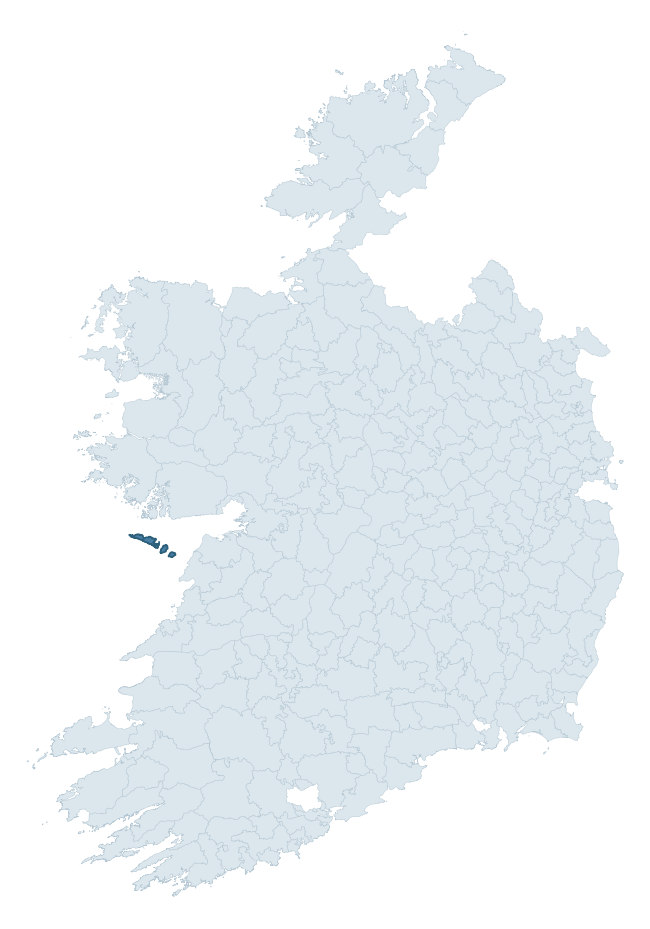
Where this barony sits in the Republic of Ireland
Geology and preservation
Bedrock geology shapes the landscape long before any settlement begins — controlling soil drainage, agricultural potential, the survival of upstanding monuments, and the preservation of buried archaeology. The figures below come from the Geological Survey Ireland 1:100,000 bedrock map.
The bedrock underlying Aran is predominantly limestone (66% of the barony by area), laid down during the Carboniferous period (100% by area, around 359 to 299 million years ago). Limestone is the most heritage-rich bedrock in Ireland. It supports fertile, well-drained soils that favoured dense Early Medieval settlement and Norman manorial agriculture, and it weathers into karst features — sinkholes, caves, swallow holes, and souterrains — that frequently carry archaeology. Where peat overlies limestone, organic preservation can be exceptional. A substantial secondary geology of limestones (34%) adds further variety to the underlying landscape. The single largest mapped unit is the Burren Formation (43% of the barony's bedrock). With only 2 distinct rock types mapped, the barony is geologically uniform compared to the rest of the Republic (11th percentile for diversity) — a single coherent bedrock landscape.
Rock type composition
Largest mapped unit: Burren Formation (43% of the barony)
Placename evidence
The Logainm record for Aran contains only 3 heritage-diagnostic placenames — 2 cill-names and 1 teampall-name. With this few records, the count should be read as indicative rather than as a firm characterisation of the linguistic heritage layers; a larger sample would be needed to reliably distinguish defensive, ecclesiastical, or other stratigraphic signals from chance occurrence.
Early Christian Ecclesiastical
| Root | Count | Meaning |
|---|---|---|
| cill- | 2 | church (early) |
| teampall- | 1 | church (later medieval) |
Other baronies in Galway
About this profile
Click any section below to expand.
What is a barony?
A barony is a historic administrative unit in Ireland, broadly equivalent to an English hundred. The 280 baronies used here are from the OSi 2019 National Statutory Boundaries (generalised 20m), covering the 26 counties of the Republic of Ireland. Baronies derive from the Norman period, were formalised in the 17th century, and have not been redrawn for statistical purposes. They vary enormously in area, from compact urban baronies in Dublin to vast upland baronies in Connacht, and should not be compared by raw site count without accounting for area differences.
What counts as a site?
This profile combines three distinct heritage registers, each with its own definition of what constitutes a recordable site:
- Archaeological sites (NMS). The National Monuments Service Sites and Monuments Record (SMR) catalogues every known archaeological monument or site of archaeological interest in the Republic, from prehistoric burial mounds and ringforts to medieval churches and post-medieval defensive works. Inclusion does not require legal protection — only that the site has been identified, surveyed, and assessed as having archaeological value. A separate subset of these sites lies within a recorded protection zone, which gives them statutory protection under the National Monuments Acts.
- Listed buildings (NIAH). The National Inventory of Architectural Heritage records buildings of architectural, historical, archaeological, artistic, cultural, scientific, social, or technical interest. Each surveyed structure is appraised on a five-tier scale: International, National, Regional, Local, and Record-Only. The NIAH appraisal is informational rather than strictly statutory, but it underpins local-authority Record of Protected Structures (RPS) listings.
- Heritage placenames (Logainm). Logainm is the authoritative database of Irish placenames maintained by the Placenames Branch. This profile applies a heritage-diagnostic classifier to the Irish-language form of each townland name, flagging roots that signal defensive sites (ráth-, lios-, dún-, caiseal-, cathair-), ecclesiastical foundations (cill-, teampall-, domhnach-, mainistir-), prehistoric burial-ritual features (tuaim-, carn-, leaba-), or Norse-contact settlement (gall-). Townlands without one of these diagnostic roots are not flagged here — they may still carry historical significance, but that significance is not encoded in the name itself.
Editorial principles
The narrative sections of this profile follow several explicit principles:
- Evidential. Every claim about this barony’s heritage character is anchored in the underlying register data. Where a site count, a placename count, or a percentile rank is cited, it is computed from the source datasets at export time, not estimated.
- Comparative. Counts and metrics are reported alongside their percentile rank against the other 279 ROI baronies. A barony with 50 ringforts in absolute terms could be unusually high or unusually low depending on its size and regional context; percentile ranking removes that ambiguity.
- Transparent on limits. Where a register has known coverage gaps, survey biases, or data-quality issues that affect this barony’s figures, the profile flags them rather than presenting the numbers as definitive.
- No interpretation beyond what the data supports. The narrative does not speculate about historical events, social dynamics, or cultural meaning beyond what the recorded heritage and placename evidence directly attests.
Data caveats and limits
- NMS Sites and Monuments Record is the product of survey campaigns conducted at different intensities across different counties and decades. Some baronies have been surveyed more thoroughly than others, and absolute counts should be read in that light. Sites destroyed by development before survey are typically not represented; sites in heavily forested or upland terrain are sometimes under-recorded.
- NIAH coverage is broadly complete for the Republic of Ireland but the survey was conducted on a rolling county-by-county basis, and the most recent appraisal date varies. Buildings demolished or substantially altered after their original survey may still appear in the register; conversely, recent buildings of merit may not yet have been appraised.
- Logainm classification applies a deliberately conservative pattern-matching approach to the Irish-language townland forms. The classifier prioritises true positives over recall: a townland may carry a heritage signal that the classifier doesn’t recognise, particularly where the diagnostic root has been heavily anglicised or where the townland name draws on a less common term. The 60,000+ townland records and ~9,800 classified placenames give a substantial signal at barony scale, but individual townland names should be checked against Logainm directly for definitive interpretation.
- Period attribution. The chronological distribution reflects only those NMS sites that carry a recognised period attribution in the source data. Sites listed as “Unknown” period are excluded from the dated subset.
- Boundary changes. Some baronies have undergone minor boundary adjustments since their 19th-century definition; the OSi 2019 generalised boundaries used here are the current statutory definition and may differ slightly from historical maps in border areas.
- Bedrock geology is mapped at 1:100,000 scale, which means local variation within a barony — small pockets of different rock type, mineral veins, alluvium overlying bedrock — is generalised. The dominant-system and rocktype figures are area-weighted, so a barony reading “70% Carboniferous limestone” may still contain small but archaeologically important pockets of older or younger rock. Around 3% of GSI polygons do not match the lexicon and contribute no rocktype or system attribution.
Data sources
- National Monuments Service — Sites and Monuments Record (SMR) https://data.gov.ie/dataset/national-monuments-service-archaeological-survey-of-ireland
- National Inventory of Architectural Heritage (NIAH) https://data.gov.ie/dataset/national-inventory-of-architectural-heritage-niah-national-dataset
- Logainm — Placenames Database of Ireland https://www.logainm.ie/
- Ordnance Survey Ireland — National Statutory Barony Boundaries 2019 https://data-osi.opendata.arcgis.com/
- EURODEM — European Digital Elevation Model https://www.mapsforeurope.org/datasets/euro-dem
- ESA WorldCover https://esa-worldcover.org/en
- Geological Survey Ireland — 1:100,000 Bedrock Geology https://www.gsi.ie/en-ie/data-and-maps/Pages/Bedrock.aspx
Explore more: Search any of the 280 ROI baronies, browse by historical province, or read the methodology and data sources for the full Republic of Ireland Heritage Tool.