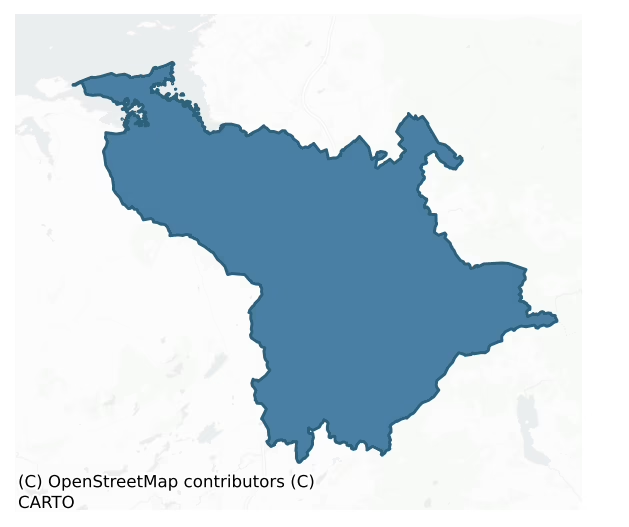
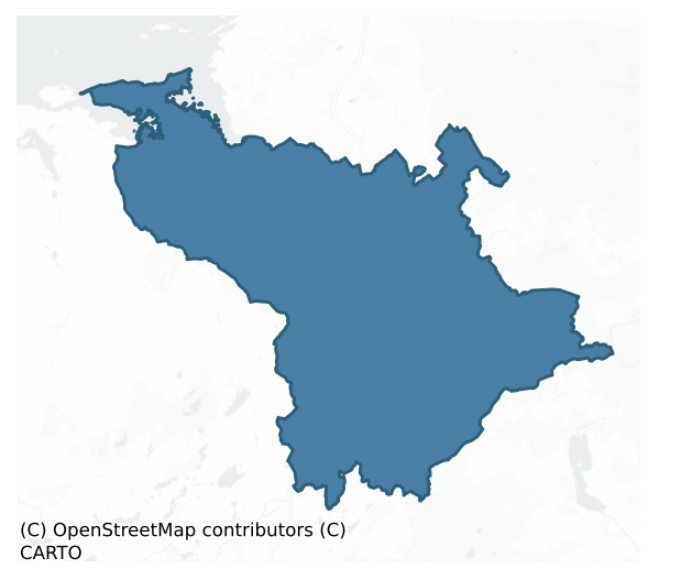
Kiltartan is a barony of County Galway, in the historical province of Connacht (Irish: Cill Tartan), covering 270 km² of land. The barony records 667 NMS archaeological sites and 145 NIAH listed buildings, placing it at around the 71st percentile among 280 ROI baronies for sites per km². This means it is in the top third of all baronies for sites per km². Dated archaeological evidence runs from the Mesolithic through to the Modern, spanning 9 of 9 archaeological periods, placing the barony in the 90th percentile among 280 ROI baronies for chronological depth. This means it is in the top tenth of all baronies for chronological depth. The largest dated subset of recorded sites dates to the Early Medieval. Logainm flags 43 placenames in the barony as carrying a recognised heritage root; the largest share — around 56% — are names associated with pre-christian defensive.
Heritage at a glance
Percentile rankings throughout this profile compare each barony only against the other 279 Republic of Ireland baronies.
The recorded heritage of Kiltartan
The National Monuments Service Sites and Monuments Record (SMR) is the statutory inventory of archaeological sites for the Republic of Ireland, maintained by the Department of Tourism, Culture, Arts, Gaeltacht, Sport and Media. Sites recorded here include earthworks, ringforts, megalithic tombs, ecclesiastical remains, and post-medieval features; not every record is legally protected, but each is registered as a monument of archaeological interest.
The National Monuments Service records 667 archaeological sites in Kiltartan, putting it at the 71st percentile among 280 ROI baronies for sites per km². This means it is in the top third of all baronies for sites per km². Protection coverage is near-universal — 605 sites (91%) fall within a recorded monument protection zone, indicating an extensively surveyed landscape. The dominant category is defensive sites — ringforts, enclosures, hillforts, and stone forts (346 sites, 52% of the record). Ringfort – cashel is the most prevalent type, making up 20% of the barony's recorded sites (131 records) — well above the ROI average of 5% across all baronies where this type occurs. Ringfort – cashel is the stone-walled equivalent of the rath, found mainly in upland or western areas, broadly dated 500–1000 AD. Other significant types include Ringfort – rath (90) and Souterrain (55). Ringfort – rath is an earthen ringfort enclosed by a bank and external ditch — the most common Early Medieval farmstead, broadly dated 500–1000 AD; Souterrain is an underground stone-built passage and chamber, generally Early Medieval and often associated with ringforts as a defensive or storage feature. Across the barony's 270 km², this gives a recorded density of 2.47 sites per km².
Most common monument types
Hover or tap a monument type to see its definition.
| Type | Count |
|---|---|
| Ringfort – cashel the stone-walled equivalent of the rath, found mainly in upland or western areas, broadly dated 500–1000 AD | 131 |
| Ringfort – rath an earthen ringfort enclosed by a bank and external ditch — the most common Early Medieval farmstead, broadly dated 500–1000 AD | 90 |
| Souterrain an underground stone-built passage and chamber, generally Early Medieval and often associated with ringforts as a defensive or storage feature | 55 |
| Enclosure a banked or ditched feature of uncertain type, used as a catch-all where the original function cannot be determined from surface evidence | 28 |
| Church a building used for public Christian worship, of any date from c. 500 AD onwards | 24 |
| House – indeterminate date a habitation building whose date cannot be determined from available evidence | 24 |
| Children's burial ground an unconsecrated medieval and early-modern burial ground for unbaptised or stillborn children, often called a cillín or ceallúnach | 21 |
Chronological distribution
The dated archaeological record for Kiltartan spans from the Mesolithic through to the Modern, with activity attested across 9 of 9 archaeological periods. This places Kiltartan in the top 10% of ROI baronies for chronological depth — few baronies record evidence across as many distinct archaeological periods. Every period from earliest to latest is represented in the record — an unbroken sequence of dated activity across the full chronological span. Activity concentrates most heavily in the Early Medieval (313 sites, 59% of dated material), with the Iron Age forming a secondary peak (132 sites, 25%). A further 135 recorded sites (20% of the overall NMS register for the barony) carry no period attribution — appearing as 'Unknown' in the bar chart below. This typically reflects either records that pre-date the standardised period vocabulary or sites awaiting specialist dating review, rather than a genuine absence of chronological evidence.
Sample of recorded monuments
Show 25 sample monuments (of 667 total)
A representative sample of 25 recorded monuments drawn from the barony’s 667 total NMS entries. Sites within a recorded monument protection zone and rarer site types are prioritised so the list shows a meaningful cross-section rather than only the most common type. Each entry shows the official Sites and Monuments Record reference number and the description published by the National Monuments Service.
Ritual site – holy/saint's stone
In grassland, close to the S shore of Galway Bay. A roughly rectangular depression (9m E-W; 6m N-S; D 0.6-0.8m) is delimited along the S and W sides by two courses of large limestone boulders. At N there is a modern…
In grassland, close to the S shore of Galway Bay. A roughly rectangular depression (9m E-W; 6m N-S; D 0.6-0.8m) is delimited along the S and W sides by two courses of large limestone boulders. At N there is a modern shrine and statue of St Kiernan, in front of which are two hollowed-out bullaun-like limestone boulders. According to Korff and O’Connell (1985, 32), an all-night vigil was held here on the last Sunday in July ‘culminating with a Feis at Tracht’.
Compiled by: Galway Archaeological Survey, UCG
Date of upload: 10 February 2020
Cross – Churchyard cross
The Archaeological Survey of Ireland (ASI) is in the process of providing information on all monuments on The Historic Environment Viewer (HEV). Currently the information for this record has not been uploaded. To…
The Archaeological Survey of Ireland (ASI) is in the process of providing information on all monuments on The Historic Environment Viewer (HEV). Currently the information for this record has not been uploaded. To access available information for research purposes please make an appointment in advance with the Archive Unit (open Fridays 10.00 am – 5.00 pm), Department of Culture, Heritage and the Gaeltacht, The Custom House, Dublin 1 D01W6XO or email nmarchive@chg.gov.ie.
Promontory fort – coastal
This promontory fort is defined along its landward side by a substantial earthen bank and external fosse which span the neck of the promontory. A wide gap halfway along the bank, with a corresponding causeway over the…
This promontory fort is defined along its landward side by a substantial earthen bank and external fosse which span the neck of the promontory. A wide gap halfway along the bank, with a corresponding causeway over the fosse, marks the entrance. Just inside it, c. 12m to the NE, lies a well-preserved bivallate rath (GA113-123001-). Outside the promontory fort defences, c. 26m to the NE, is a small low flat-topped mound (11m E-W; 8.5m N-S; max. H 0.75m). It may be associated. This impressive monument is probably the site of the original Dún Guaire (alias Rath Durlais), chief residence of the famed 6th C. King Guaire (Killanin and Duignan 1967, 343) which a number of writers (O'Flanagan 1927, Vol. 1, 297; Fahey 1893, 197; Leask 1973 122; Hynes 1980) have erroneously placed on the site of the nearby castle (GA113-124—-). (Westropp 1919, 167-86; Korff and O'Connell 1985)
Compiled by: Galway Archaeological Survey, UCG
Date of upload: 4 August 2017
Kiln – lime
The Archaeological Survey of Ireland (ASI) is in the process of providing information on all monuments on The Historic Environment Viewer (HEV). Currently the information for this record has not been uploaded. To…
The Archaeological Survey of Ireland (ASI) is in the process of providing information on all monuments on The Historic Environment Viewer (HEV). Currently the information for this record has not been uploaded. To access available information for research purposes please make an appointment in advance with the Archive Unit (open Fridays 10.00 am – 5.00 pm), Department of Culture, Heritage and the Gaeltacht, The Custom House, Dublin 1 D01W6XO or email nmarchive@chg.gov.ie.
Barrow – mound barrow
On a gentle S-facing slope in pastureland. An oval flat-topped earthen mound (9m NW-SE; 8m NE-SW; H 0.85m), in fair condition, is clipped by a N-S running field wall at W. Rynne (SMR file) suggests that it may possibly…
On a gentle S-facing slope in pastureland. An oval flat-topped earthen mound (9m NW-SE; 8m NE-SW; H 0.85m), in fair condition, is clipped by a N-S running field wall at W. Rynne (SMR file) suggests that it may possibly be a barrow.
Compiled by: Galway Archaeological Survey, UCG
Date of upload: 30 July 2019
Barrow – embanked barrow
On a slight rise in pastureland. Circular enclosure (diam. 18.5m), in fair condition, defined by a substantial bank of earth and stone. It has been levelled from E to SSE. The interior rises slightly towards the centre.…
On a slight rise in pastureland. Circular enclosure (diam. 18.5m), in fair condition, defined by a substantial bank of earth and stone. It has been levelled from E to SSE. The interior rises slightly towards the centre. Possibly a barrow. A quarry pit lies immediately to the S.
Compiled by: Galway Archaeological Survey, UCG
Date of upload: 17 June 2019
Mine
The Archaeological Survey of Ireland (ASI) is in the process of providing information on all monuments on The Historic Environment Viewer (HEV). Currently the information for this record has not been uploaded. To…
The Archaeological Survey of Ireland (ASI) is in the process of providing information on all monuments on The Historic Environment Viewer (HEV). Currently the information for this record has not been uploaded. To access available information for research purposes please make an appointment in advance with the Archive Unit (open Fridays 10.00 am – 5.00 pm), Department of Culture, Heritage and the Gaeltacht, The Custom House, Dublin 1 D01W6XO or email nmarchive@chg.gov.ie.
Burial
This is a modern burial vault.
Compiled by: Olive Alcock
Date of upload: 11 October 2017
Megalithic tomb – portal tomb
On a belt of flat limestone cragland, some 700m NE of a wedge-tomb (GA122-019—-). This tomb consists of a cairn L 22m; Wth c. 9m), aligned NNE-SSW, incorporating towards its N end a well-preserved chamber formed of…
On a belt of flat limestone cragland, some 700m NE of a wedge-tomb (GA122-019—-). This tomb consists of a cairn L 22m; Wth c. 9m), aligned NNE-SSW, incorporating towards its N end a well-preserved chamber formed of two tall portal-stones, two narrow sidestones and a large backstone; the whole is covered by a large roofstone. (Killanin and Duignan 1967, 300; de Valera and Ó Nualláin 1972, 20-1; Weir 1980, 149)
See linked document with details from Ruaidhrí de Valera and Seán Ó Nualláin, Survey of the Megalithic Tombs of Ireland. Volume III. Counties Galway, Roscommon, Leitrim, Longford, Westmeath, Laoighis, Offaly, Kildare, Cavan. (Dublin: Stationery Office, 1972).
Compiled by: Galway Archaeological Survey, UCG
Date of upload: 16 August 2019
Ritual site – pond
The Archaeological Survey of Ireland (ASI) is in the process of providing information on all monuments on The Historic Environment Viewer (HEV). Currently the information for this record has not been uploaded. To…
The Archaeological Survey of Ireland (ASI) is in the process of providing information on all monuments on The Historic Environment Viewer (HEV). Currently the information for this record has not been uploaded. To access available information for research purposes please make an appointment in advance with the Archive Unit (open Fridays 10.00 am – 5.00 pm), Department of Culture, Heritage and the Gaeltacht, The Custom House, Dublin 1 D01W6XO or email nmarchive@chg.gov.ie.
School
The Archaeological Survey of Ireland (ASI) is in the process of providing information on all monuments on The Historic Environment Viewer (HEV). Currently the information for this record has not been uploaded. To…
The Archaeological Survey of Ireland (ASI) is in the process of providing information on all monuments on The Historic Environment Viewer (HEV). Currently the information for this record has not been uploaded. To access available information for research purposes please make an appointment in advance with the Archive Unit (open Fridays 10.00 am – 5.00 pm), Department of Culture, Heritage and the Gaeltacht, The Custom House, Dublin 1 D01W6XO or email nmarchive@chg.gov.ie.
Barrow – bowl-barrow
On a ridge in pastureland. This poorly preserved circular ring-barrow (diam. 22m) comprises a central mound (diam. c. 8m; H 1.12-1.18m) encircled by a fosse and external bank. There is a possible entrance gap at WSW.…
On a ridge in pastureland. This poorly preserved circular ring-barrow (diam. 22m) comprises a central mound (diam. c. 8m; H 1.12-1.18m) encircled by a fosse and external bank. There is a possible entrance gap at WSW. The monument is overgrown with trees.
Compiled by: Galway Archaeological Survey, UCG
Date of upload: 16 August 2019
Water mill – vertical-wheeled
The Archaeological Survey of Ireland (ASI) is in the process of providing information on all monuments on The Historic Environment Viewer (HEV). Currently the information for this record has not been uploaded. To…
The Archaeological Survey of Ireland (ASI) is in the process of providing information on all monuments on The Historic Environment Viewer (HEV). Currently the information for this record has not been uploaded. To access available information for research purposes please make an appointment in advance with the Archive Unit (open Fridays 10.00 am – 5.00 pm), Department of Culture, Heritage and the Gaeltacht, The Custom House, Dublin 1 D01W6XO or email nmarchive@chg.gov.ie.
Altar
In grassland close to the N bank of the Beagh River, in an area known locally as ‘Bushy Hollow’. This altar consists of a wedge-shaped drystone-built structure (L 12.7m; Wth 3.4m) facing NNW. Two trees are now growing…
In grassland close to the N bank of the Beagh River, in an area known locally as ‘Bushy Hollow’. This altar consists of a wedge-shaped drystone-built structure (L 12.7m; Wth 3.4m) facing NNW. Two trees are now growing out of it. A stone cross (GA123-027002-) is set upright in the centre of the altar and a bullaun stone (GA123-027001-) lies to the NNW; a number of coins are placed in its hollow. Mass was offered here in the early penal days (Glynn 1908, 193). The monument appears to be still regarded as a place of worship.
Compiled by: Galway Archaeological Survey, UCG
Date of upload: 29 January 2020
Castle – Anglo-Norman masonry castle
On steeply rising ground on the W bank of the Gort River in gently undulating pastureland. This National Monument comprises a much-ruined 13th-century de Burgo castle and bawn (Harbison 1975, 96). Known alternatively as…
On steeply rising ground on the W bank of the Gort River in gently undulating pastureland. This National Monument comprises a much-ruined 13th-century de Burgo castle and bawn (Harbison 1975, 96). Known alternatively as 'Ballinamantaine' castle (Leask 1973, 156), a name still preserved in an adjoining townland, it appears to be named 'Ballecastle' in the 1574 list of castles in Co. Galway when it was then in the possession of 'Mac Remon' (Nolan 1901, 114). The castle consists of an almost square three-storey high building (ext. dims. 11.7m N-S; 11.5m E-W) with a projecting angle at the SE corner. It is constructed of heavily mortared randomly coursed undressed limestone blocks. There is a pronounced base-batter and the base at the SE corner has been reinforced. Access is via a robbed-out doorway on the ground floor, at the N end of the W wall. It accesses a lobby, to the S of which there is a narrow passage (Wth 1.45m) running N-S. An arched entrance at the S end of wall of this passage accesses the main room (10m E-W; 5.25m N-S), the present layout of which dates to the late-medieval period when a wickerwork-centred vault supported by four pillars was inserted. The SE corner of the room is obscured due to the collapse of the roof and it was not possible to determine if its layout mirrored that of the external projecting wall-face. Two sets of straight intramural stairs ascend from the ground to the 1st floor: one from the SW corner and along the S wall, and the other from…
Cairn – clearance cairn
The Archaeological Survey of Ireland (ASI) is in the process of providing information on all monuments on The Historic Environment Viewer (HEV). Currently the information for this record has not been uploaded. To…
The Archaeological Survey of Ireland (ASI) is in the process of providing information on all monuments on The Historic Environment Viewer (HEV). Currently the information for this record has not been uploaded. To access available information for research purposes please make an appointment in advance with the Archive Unit (open Fridays 10.00 am – 5.00 pm), Department of Culture, Heritage and the Gaeltacht, The Custom House, Dublin 1 D01W6XO or email nmarchive@chg.gov.ie.
Burnt mound
On marshy ground c. 13m to the SE of a stream. This burnt mound is defined by a well-preserved subcircular mound (diam. 12.8m; H 0.6m) composed of burnt soil and stones. A fulacht fia (GA123-093—-) lies c. 255m to the…
On marshy ground c. 13m to the SE of a stream. This burnt mound is defined by a well-preserved subcircular mound (diam. 12.8m; H 0.6m) composed of burnt soil and stones. A fulacht fia (GA123-093—-) lies c. 255m to the SW.
Compiled by: Galway Archaeological Survey, UCG
Date of upload: 27 November 2019
Cairn – unclassified
The Archaeological Survey of Ireland (ASI) is in the process of providing information on all monuments on The Historic Environment Viewer (HEV). Currently the information for this record has not been uploaded. To…
The Archaeological Survey of Ireland (ASI) is in the process of providing information on all monuments on The Historic Environment Viewer (HEV). Currently the information for this record has not been uploaded. To access available information for research purposes please make an appointment in advance with the Archive Unit (open Fridays 10.00 am – 5.00 pm), Department of Culture, Heritage and the Gaeltacht, The Custom House, Dublin 1 D01W6XO or email nmarchive@chg.gov.ie.
Megalithic tomb – unclassified
The Archaeological Survey of Ireland (ASI) is in the process of providing information on all monuments on The Historic Environment Viewer (HEV). Currently the information for this record has not been uploaded. To…
The Archaeological Survey of Ireland (ASI) is in the process of providing information on all monuments on The Historic Environment Viewer (HEV). Currently the information for this record has not been uploaded. To access available information for research purposes please make an appointment in advance with the Archive Unit (open Fridays 10.00 am – 5.00 pm), Department of Culture, Heritage and the Gaeltacht, The Custom House, Dublin 1 D01W6XO or email nmarchive@chg.gov.ie.
Gateway
Circa 40m to the SE of the tower house (GA114-144—-) are the remains of an arched gateway built of rough stone blocks and mortar. Walls extend off either side of it, to the NE and SW. The arch is circular in shape…
Circa 40m to the SE of the tower house (GA114-144—-) are the remains of an arched gateway built of rough stone blocks and mortar. Walls extend off either side of it, to the NE and SW. The arch is circular in shape (Wth 1.9m; H 3m) and the keystone on its external wall-face bears the following letters and date: D NE 1738. A hanging eye is visible on either side of the arch on the internal wall-face. The gateway appears to have been part of a building or courtyard.
Compiled by: Olive Alcock
Date of upload: 22 September 2017
Bee-boles
The Archaeological Survey of Ireland (ASI) is in the process of providing information on all monuments on The Historic Environment Viewer (HEV). Currently the information for this record has not been uploaded. To…
The Archaeological Survey of Ireland (ASI) is in the process of providing information on all monuments on The Historic Environment Viewer (HEV). Currently the information for this record has not been uploaded. To access available information for research purposes please make an appointment in advance with the Archive Unit (open Fridays 10.00 am – 5.00 pm), Department of Culture, Heritage and the Gaeltacht, The Custom House, Dublin 1 D01W6XO or email nmarchive@chg.gov.ie.
Cross-inscribed stone
In a reclaimed field immediately to the E of an N-S running road and associated with a children's burial ground (GA112-04001-). A trapezoidal-shaped slab (H 0.58m; Wth 0.44m; D 0.37m), built into the W field boundary,…
In a reclaimed field immediately to the E of an N-S running road and associated with a children's burial ground (GA112-04001-). A trapezoidal-shaped slab (H 0.58m; Wth 0.44m; D 0.37m), built into the W field boundary, is carved with a Latin cross in low relief.
Compiled by: Galway Archaeological Survey, UCG
Date of upload: 29 August 2019
Religious house – Augustinian canons
Part of the monastic complex at Kilmacduagh, this National Monument is located in low-lying grassland, flanked to the SW, W and NNE by marshy land, and close to the county boundary between Galway and Clare. It was built…
Part of the monastic complex at Kilmacduagh, this National Monument is located in low-lying grassland, flanked to the SW, W and NNE by marshy land, and close to the county boundary between Galway and Clare. It was built by the Augustinian Canons in the first half of the 13th century (Harbison 1975, 95) under the patronage of the O’Heynes (Fahey 1904, 227) and it replaced an earlier monastery (see GA128-034004-). The present remains show unmistakable evidence of restoration at different periods (Fahey 1904, 227). The main buildings are the nave (E-W; L 17.2m; Wth c. 6.8m) and chancel (L 5.8m; Wth c. 6.7m) church, with the sacristy and conventual buildings extending to the S, from the E end of the nave. The wall-footings immediately to the N of the nave indicate that the church was originally wider. The present wall was probably built following the collapse of this earlier wall in the 14th or 15th century (Harbison 1975, 95). Towards the W end of the wall, a foundation line (L 22m) running NNE-SSW is also evident. At its N end it turns eastwards (L c. 14m) before it becomes obscured by a later field wall and overgrowth. In this section the remains of an arched door/gateway survive. The main architectural features of the church include pointed arch doorways in the N and S walls of the nave, and columns with decorated capitals, which supported the now missing chancel arch. In the chancel, the E gable has a fine two-light round-headed window with hood- and roll-mouldings. Set i…
Castle – hall-house
Part of the monastic complex at Kilmacduagh and situated 100m to the NNE of the cathedral (GA128-034004-). This edifice, now a National Monument, has been variously interpreted as a 'seminary' and/or the residence of…
Part of the monastic complex at Kilmacduagh and situated 100m to the NNE of the cathedral (GA128-034004-). This edifice, now a National Monument, has been variously interpreted as a 'seminary' and/or the residence of the abbot or bishop (Fahey 1904, 230; Harbison 1975, 95). The original building was a rectangular two-storey hall-house (16.2m E-W; 6.7m N-S), aligned roughly E-W, that was accessed via a doorway at 1st-floor level in the S wall. It most likely dates to the 13th century but a number of major alterations are evident, most recently the restoration which involved re-roofing the E half of the building with a gabled roof and crenellated parapet. Only the E jamb of the original doorway survives. Below and slightly to the E of it is a beam slot which probably supported the external wooden staircase. The ground-floor chamber appears to have been originally roofed with wooden beams, the slots for which survive internally at the W end. It was lit by narrow slit windows, set in wide embrasures, in contrast to the original 1st floor which was lit by a number of two-light cusped and pointed-arch windows. The ground and 1st-floor chambers are now subdivided by an internal wall. This is possibly part of a late medieval re-edification which saw the E part rebuilt as a three-storey tower house-like building. The entrance to this is via a pointed-arch doorway at ground-floor level at the E end of the S wall. Fahey (1904, 230) noted 'an oriel [window], looking north-east … on th…
Ringfort – cashel
In level pastureland. Very well-preserved circular cashel (diam. 30m) defined by a drystone wall (H 2.25m; Wth 2.28m), which is faced both internally and externally with massive limestone blocks. It is partly obscured…
In level pastureland. Very well-preserved circular cashel (diam. 30m) defined by a drystone wall (H 2.25m; Wth 2.28m), which is faced both internally and externally with massive limestone blocks. It is partly obscured by field-clearance rubble at S. There is an entrance gap (Wth 2.15m at ESE. The remains of at least four rectangular structures are visible within the interior; those at N and S are contemporary with the cashel wall and may be house sites. Those in the centre and to the W appear to have been modified and remodelled as a limekilns. (SMR file; Korff and O'Connell 1985)
Compiled by: Galway Archaeological Survey, UCG
Date of upload: 10 January 2017
Listed buildings
The National Inventory of Architectural Heritage (NIAH) is a state survey appraising buildings of architectural, historical, archaeological, artistic, cultural, scientific, social, or technical interest. Each surveyed structure receives a rating from International (the highest, for buildings of European importance) through National, Regional, Local, and Record-Only.
The NIAH records 145 listed buildings in Kiltartan (66th percentile across ROI baronies). The highest-graded structure include 1 of National significance. The Republic holds 937 National-graded buildings in total, so this barony accounts for around 0% of the national total. Construction dates concentrate most heavily in the Late Georgian (1800-1830) period. The most-recorded building type is house (72 examples, 50% of the listed stock).
Terrain and environment
Mean elevation across the barony is 38m — the 10th percentile among 280 ROI baronies for elevation. This means it is in the bottom fifth of all baronies for elevation. This is a relatively low-lying landscape by ROI standards. Elevation matters for heritage because higher-altitude baronies typically favour defensive monuments — ringforts and hilltop forts placed on prominent ground — while lowland baronies are more likely to carry the dense settlement and church networks of intensive agricultural landscapes. The barony reaches 258m at its highest point — a vertical span of more than 220m within its boundary, indicating significant topographic diversity. Mean slope is 3.5° — the 47th percentile among 280 ROI baronies for slope. This means it is in the lower half of all baronies for slope. Slope is a key control on both land use and archaeological preservation: steep ground resists ploughing and tends to preserve earthworks intact, while gentle slopes favour intensive cultivation that damages or destroys surface archaeology over time. The Topographic Wetness Index averages 10.9, the 52nd percentile among 280 ROI baronies for wetness. This means it is in the upper half of all baronies for wetness. Drainage matters for heritage because poorly-drained ground preserves organic archaeology (wooden trackways, leather, textiles, and on rare occasions human remains) far better than free-draining soil; well-drained ground favours arable use but destroys organic material rapidly. The land cover is dominated by improved grassland (71%) and woodland (25%).
Terrain measurements
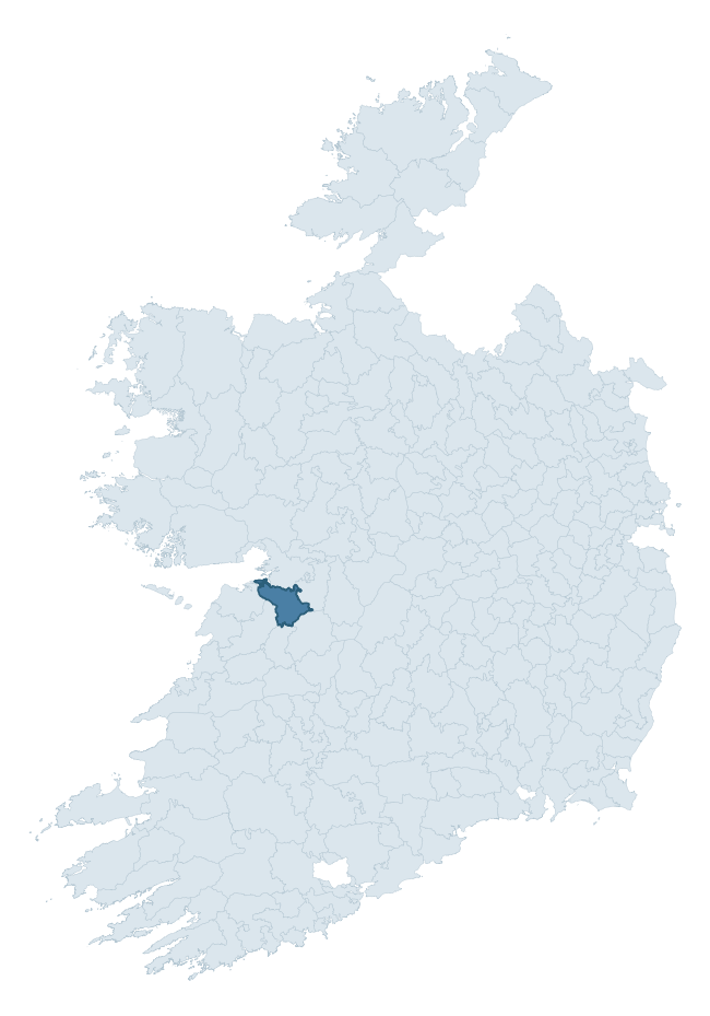
Where this barony sits in the Republic of Ireland
Geology and preservation
Bedrock geology shapes the landscape long before any settlement begins — controlling soil drainage, agricultural potential, the survival of upstanding monuments, and the preservation of buried archaeology. The figures below come from the Geological Survey Ireland 1:100,000 bedrock map.
The bedrock underlying Kiltartan is predominantly limestone (82% of the barony by area), laid down during the Carboniferous period (85% by area, around 359 to 299 million years ago). Limestone is the most heritage-rich bedrock in Ireland. It supports fertile, well-drained soils that favoured dense Early Medieval settlement and Norman manorial agriculture, and it weathers into karst features — sinkholes, caves, swallow holes, and souterrains — that frequently carry archaeology. Where peat overlies limestone, organic preservation can be exceptional.
Rock type composition
Largest mapped unit: Hawkhill Member (Burren Formation) (24% of the barony)
Placename evidence
Logainm records 43 heritage-diagnostic placenames for Kiltartan, drawn from townland and civil-parish names across the barony. The dominant stratum is pre-Christian and Early Medieval defensive — ráth-, lios-, dún-, and caiseal-prefixed names that mark Iron Age and early historic settlement. The leading diagnostic roots are cill- (14 — church), cathair- (8 — stone fort), and ráth- (7 — earthen ringfort). This is above the ROI average of 30.7 heritage placenames per barony. The presence of multiple heritage strata side by side indicates layered occupation of the landscape across successive prehistoric and historic periods. Logainm records 269 placenames for Kiltartan (predominantly townland names). Of these, 43 (16%) carry one of the diagnostic Gaelic roots tracked above; the remainder draw on more generic landscape vocabulary that does not encode a heritage period.
Pre-Christian / Early Medieval Defensive
| Root | Count | Meaning |
|---|---|---|
| cathair- | 8 | stone fort |
| ráth- | 7 | earthen ringfort |
| lios- | 5 | ringfort or enclosure |
| dún- | 3 | hilltop or promontory fort |
| caiseal- | 1 | stone ringfort |
Early Christian Ecclesiastical
| Root | Count | Meaning |
|---|---|---|
| cill- | 14 | church (early) |
| cillín- | 3 | unconsecrated burial ground |
Burial, Ritual, and Norse-Contact
| Root | Count | Meaning |
|---|---|---|
| carn- | 1 | cairn |
| leacht- | 1 | grave monument |
Other baronies in Galway
About this profile
Click any section below to expand.
What is a barony?
A barony is a historic administrative unit in Ireland, broadly equivalent to an English hundred. The 280 baronies used here are from the OSi 2019 National Statutory Boundaries (generalised 20m), covering the 26 counties of the Republic of Ireland. Baronies derive from the Norman period, were formalised in the 17th century, and have not been redrawn for statistical purposes. They vary enormously in area, from compact urban baronies in Dublin to vast upland baronies in Connacht, and should not be compared by raw site count without accounting for area differences.
What counts as a site?
This profile combines three distinct heritage registers, each with its own definition of what constitutes a recordable site:
- Archaeological sites (NMS). The National Monuments Service Sites and Monuments Record (SMR) catalogues every known archaeological monument or site of archaeological interest in the Republic, from prehistoric burial mounds and ringforts to medieval churches and post-medieval defensive works. Inclusion does not require legal protection — only that the site has been identified, surveyed, and assessed as having archaeological value. A separate subset of these sites lies within a recorded protection zone, which gives them statutory protection under the National Monuments Acts.
- Listed buildings (NIAH). The National Inventory of Architectural Heritage records buildings of architectural, historical, archaeological, artistic, cultural, scientific, social, or technical interest. Each surveyed structure is appraised on a five-tier scale: International, National, Regional, Local, and Record-Only. The NIAH appraisal is informational rather than strictly statutory, but it underpins local-authority Record of Protected Structures (RPS) listings.
- Heritage placenames (Logainm). Logainm is the authoritative database of Irish placenames maintained by the Placenames Branch. This profile applies a heritage-diagnostic classifier to the Irish-language form of each townland name, flagging roots that signal defensive sites (ráth-, lios-, dún-, caiseal-, cathair-), ecclesiastical foundations (cill-, teampall-, domhnach-, mainistir-), prehistoric burial-ritual features (tuaim-, carn-, leaba-), or Norse-contact settlement (gall-). Townlands without one of these diagnostic roots are not flagged here — they may still carry historical significance, but that significance is not encoded in the name itself.
Editorial principles
The narrative sections of this profile follow several explicit principles:
- Evidential. Every claim about this barony’s heritage character is anchored in the underlying register data. Where a site count, a placename count, or a percentile rank is cited, it is computed from the source datasets at export time, not estimated.
- Comparative. Counts and metrics are reported alongside their percentile rank against the other 279 ROI baronies. A barony with 50 ringforts in absolute terms could be unusually high or unusually low depending on its size and regional context; percentile ranking removes that ambiguity.
- Transparent on limits. Where a register has known coverage gaps, survey biases, or data-quality issues that affect this barony’s figures, the profile flags them rather than presenting the numbers as definitive.
- No interpretation beyond what the data supports. The narrative does not speculate about historical events, social dynamics, or cultural meaning beyond what the recorded heritage and placename evidence directly attests.
Data caveats and limits
- NMS Sites and Monuments Record is the product of survey campaigns conducted at different intensities across different counties and decades. Some baronies have been surveyed more thoroughly than others, and absolute counts should be read in that light. Sites destroyed by development before survey are typically not represented; sites in heavily forested or upland terrain are sometimes under-recorded.
- NIAH coverage is broadly complete for the Republic of Ireland but the survey was conducted on a rolling county-by-county basis, and the most recent appraisal date varies. Buildings demolished or substantially altered after their original survey may still appear in the register; conversely, recent buildings of merit may not yet have been appraised.
- Logainm classification applies a deliberately conservative pattern-matching approach to the Irish-language townland forms. The classifier prioritises true positives over recall: a townland may carry a heritage signal that the classifier doesn’t recognise, particularly where the diagnostic root has been heavily anglicised or where the townland name draws on a less common term. The 60,000+ townland records and ~9,800 classified placenames give a substantial signal at barony scale, but individual townland names should be checked against Logainm directly for definitive interpretation.
- Period attribution. The chronological distribution reflects only those NMS sites that carry a recognised period attribution in the source data. Sites listed as “Unknown” period are excluded from the dated subset.
- Boundary changes. Some baronies have undergone minor boundary adjustments since their 19th-century definition; the OSi 2019 generalised boundaries used here are the current statutory definition and may differ slightly from historical maps in border areas.
- Bedrock geology is mapped at 1:100,000 scale, which means local variation within a barony — small pockets of different rock type, mineral veins, alluvium overlying bedrock — is generalised. The dominant-system and rocktype figures are area-weighted, so a barony reading “70% Carboniferous limestone” may still contain small but archaeologically important pockets of older or younger rock. Around 3% of GSI polygons do not match the lexicon and contribute no rocktype or system attribution.
Data sources
- National Monuments Service — Sites and Monuments Record (SMR) https://data.gov.ie/dataset/national-monuments-service-archaeological-survey-of-ireland
- National Inventory of Architectural Heritage (NIAH) https://data.gov.ie/dataset/national-inventory-of-architectural-heritage-niah-national-dataset
- Logainm — Placenames Database of Ireland https://www.logainm.ie/
- Ordnance Survey Ireland — National Statutory Barony Boundaries 2019 https://data-osi.opendata.arcgis.com/
- EURODEM — European Digital Elevation Model https://www.mapsforeurope.org/datasets/euro-dem
- ESA WorldCover https://esa-worldcover.org/en
- Geological Survey Ireland — 1:100,000 Bedrock Geology https://www.gsi.ie/en-ie/data-and-maps/Pages/Bedrock.aspx
Explore more: Search any of the 280 ROI baronies, browse by historical province, or read the methodology and data sources for the full Republic of Ireland Heritage Tool.