Kilconnell is a barony of County Galway, in the historical province of Connacht (Irish: Cill Chonaill), covering 262 km² of land. The barony records 719 NMS archaeological sites and 69 NIAH listed buildings, placing it at around the 76th percentile among 280 ROI baronies for sites per km². This means it is in the top third of all baronies for sites per km². Dated archaeological evidence runs from the Early Bronze Age through to the Modern, spanning 7 of 9 archaeological periods, placing the barony in the 27th percentile among 280 ROI baronies for chronological depth. This means it is in the bottom third of all baronies for chronological depth. The largest dated subset of recorded sites dates to the Early Medieval. Logainm flags 34 placenames in the barony as carrying a recognised heritage root; the largest share — around 56% — are names associated with pre-christian defensive.
Heritage at a glance
Percentile rankings throughout this profile compare each barony only against the other 279 Republic of Ireland baronies.
The recorded heritage of Kilconnell
The National Monuments Service Sites and Monuments Record (SMR) is the statutory inventory of archaeological sites for the Republic of Ireland, maintained by the Department of Tourism, Culture, Arts, Gaeltacht, Sport and Media. Sites recorded here include earthworks, ringforts, megalithic tombs, ecclesiastical remains, and post-medieval features; not every record is legally protected, but each is registered as a monument of archaeological interest.
The National Monuments Service records 719 archaeological sites in Kilconnell, putting it at the 76th percentile among 280 ROI baronies for sites per km². This means it is in the top third of all baronies for sites per km². Of these, 557 (78%) fall within a recorded monument protection zone. The dominant category is defensive sites — ringforts, enclosures, hillforts, and stone forts (385 sites, 54% of the record). Ringfort – unclassified is the most prevalent type, making up 19% of the barony's recorded sites (138 records) — well above the ROI average of 4% across all baronies where this type occurs. Ringfort – unclassified is a circular Early Medieval settlement enclosure where surviving evidence does not allow distinction between earthen and stone forms. Other significant types include Enclosure (122) and Quarry (72). Enclosure is a banked or ditched feature of uncertain type, used as a catch-all where the original function cannot be determined from surface evidence; Quarry is a place where stone, sand, gravel or clay was extracted. Across the barony's 262 km², this gives a recorded density of 2.74 sites per km².
Most common monument types
Hover or tap a monument type to see its definition.
| Type | Count |
|---|---|
| Ringfort – unclassified a circular Early Medieval settlement enclosure where surviving evidence does not allow distinction between earthen and stone forms | 138 |
| Enclosure a banked or ditched feature of uncertain type, used as a catch-all where the original function cannot be determined from surface evidence | 122 |
| Quarry a place where stone, sand, gravel or clay was extracted | 72 |
| Ringfort – rath an earthen ringfort enclosed by a bank and external ditch — the most common Early Medieval farmstead, broadly dated 500–1000 AD | 50 |
| Souterrain an underground stone-built passage and chamber, generally Early Medieval and often associated with ringforts as a defensive or storage feature | 49 |
| Children's burial ground an unconsecrated medieval and early-modern burial ground for unbaptised or stillborn children, often called a cillín or ceallúnach | 33 |
| Church a building used for public Christian worship, of any date from c. 500 AD onwards | 19 |
Chronological distribution
The dated archaeological record for Kilconnell spans from the Early Bronze Age through to the Modern, with activity attested across 7 of 9 archaeological periods. Every period from earliest to latest is represented in the record — an unbroken sequence of dated activity across the full chronological span. Activity concentrates most heavily in the Early Medieval (270 sites, 54% of dated material), with the Iron Age forming a secondary peak (182 sites, 36%). A further 218 recorded sites (30% of the overall NMS register for the barony) carry no period attribution — appearing as 'Unknown' in the bar chart below. This typically reflects either records that pre-date the standardised period vocabulary or sites awaiting specialist dating review, rather than a genuine absence of chronological evidence.
Sample of recorded monuments
Show 25 sample monuments (of 719 total)
A representative sample of 25 recorded monuments drawn from the barony’s 719 total NMS entries. Sites within a recorded monument protection zone and rarer site types are prioritised so the list shows a meaningful cross-section rather than only the most common type. Each entry shows the official Sites and Monuments Record reference number and the description published by the National Monuments Service.
Burial mound
On gently undulating farmland immediately NE of a byroad. Originally a stony circular mound (D 35m, H 5.5m), the SW half was completely removed in 1977 during road widening. This revealed a cist composed of at least six…
On gently undulating farmland immediately NE of a byroad. Originally a stony circular mound (D 35m, H 5.5m), the SW half was completely removed in 1977 during road widening. This revealed a cist composed of at least six slabs, only three of which remain in situ, though now partially slipped. These indicate a chamber (Wth c. 1.5m, H c. 1.8m ext.) aligned approximately NE-SW. According to local information, a quantity of bone was removed from the cist.
The above description is derived from the published 'Archaeological Inventory of County Galway Vol. II – North Galway'. Compiled by Olive Alcock, Kathy de hÓra and Paul Gosling (Dublin: Stationery Office, 1999).
Date of upload: 05 August 2010
Castle – motte
On a steep hill in marshy scrubland. Poorly preserved overgrown circular mound (D c. 40m) with very steep sides on W, N and E faces (H > 7m). The summit (D 15m) is much disturbed.
The above description is derived…
On a steep hill in marshy scrubland. Poorly preserved overgrown circular mound (D c. 40m) with very steep sides on W, N and E faces (H > 7m). The summit (D 15m) is much disturbed.
The above description is derived from the published 'Archaeological Inventory of County Galway Vol. II – North Galway'. Compiled by Olive Alcock, Kathy de hÓra and Paul Gosling (Dublin: Stationery Office, 1999).
Date of upload: 05 August 2010
Crannog
In the W half of Callow Lough. This tree-covered crannog has been described by Curley (2021, 27-30-1) as a roughly circular artificial island (diam. c. 30m), rising 2m above the waterline. Its perimeter is defined by a…
In the W half of Callow Lough. This tree-covered crannog has been described by Curley (2021, 27-30-1) as a roughly circular artificial island (diam. c. 30m), rising 2m above the waterline. Its perimeter is defined by a revetment of large square stones, inside of which a substantial dump of stone and earth was piled. A subrectangular stone structure (GA073-032001-) is centrally located on it. On its E side, a stone-built jetty (L 7-8m; Wth c. 0.7m), defined by two stone linear features, is visible beneath the waterline.
Following Fredengren (2002, 83-6), Curley (ibid., 28) suggests that the crannog could be classed as a high-cairn crannog and is possibly of late-medieval date. It may have been part of the historically attested ‘Callow cenn áit’ or lordly centre of the Ó Cellaig (O’Kelly) of Uí Maine and Tír Maine (ibid., 4, 27) and it may be connected with the castle (GA073-027—-) on the shoreline c. 180m to the SSW. (Alcock et al. 1999, 30)
Compiled by: Olive Alcock
Date of upload: 14 December 2022
References:
Alcock, O., de Hora, K. and Gosling, P. 1999 Archaeological Inventory of County Galway. Vol. II. North Galway. Dublin. Stationery Office.
Curley, D. 2021 Le triúcha chéd in Chalaidh a máeraidecht idir mincís agus mórthobach – Multidisciplinary approaches to recoverning an Ó Cellaig cenn áit in later medieval Uí Maine. Eolas 13, 2-42.
Fredengren, C. 2002 Crannogs: a study of people's interaction with lakes, with particular reference to Lough Gar…
Enclosure – large enclosure
On a ridge in grassland, c. 100m N of the td. boundary. Poorly preserved pear-shaped enclosure (N-S 76m, E-W 76m) defined by two banks and an intervening fosse. The inner bank is visible at N and S; elsewhere a scarp…
On a ridge in grassland, c. 100m N of the td. boundary. Poorly preserved pear-shaped enclosure (N-S 76m, E-W 76m) defined by two banks and an intervening fosse. The inner bank is visible at N and S; elsewhere a scarp forms the enclosing element. The fosse and outer bank survive from SW to N. A causewayed-gap (Wth 3.5m) at NW may indicate the original entrance. Within SE quadrant of the interior is a CBG (GA073-145001-). Its presence, when coupled with the size of this monument and its proximity to the td. boundary, raises the possibility that it could be an early ecclesiastical enclosure. A possible rath (GA073-165—-) lies c. 90m to the NNE.
The above description is derived from the published 'Archaeological Inventory of County Galway Vol. II – North Galway'. Compiled by Olive Alcock, Kathy de hÓra and Paul Gosling (Dublin: Stationery Office, 1999).
Updated by: Olive Alcock
Date of revised upload: 11 May 2021
Fulacht fia
The Archaeological Survey of Ireland (ASI) is in the process of providing information on all monuments on The Historic Environment Viewer (HEV). Currently the information for this record has not been uploaded. To…
The Archaeological Survey of Ireland (ASI) is in the process of providing information on all monuments on The Historic Environment Viewer (HEV). Currently the information for this record has not been uploaded. To access available information for research purposes please make an appointment in advance with the Archive Unit (open Fridays 10.00 am – 5.00 pm), Department of Culture, Heritage and the Gaeltacht, The Custom House, Dublin 1 D01W6XO or email nmarchive@chg.gov.ie.
Religious house – Franciscan friars
In undulating grassland to the N of Kilconnell village. A restored Nat. Mon., this Franciscan friary appears to have been founded in 1353 by William O'Kelly, probably on or close to the site of St Conall's early…
In undulating grassland to the N of Kilconnell village. A restored Nat. Mon., this Franciscan friary appears to have been founded in 1353 by William O'Kelly, probably on or close to the site of St Conall's early monastery (Gwynn and Hadcock 1970, 251, 389; Harbison 1975, 94). According to Killanin and Duignan (1967, 316), it was 'reconstructed' in 1414 and it adopted the Observantine reform in 1464. An inquisition taken on the 20th of February in the 14th year of the reign of James 1 (1617), found that ‘that the site of this abbey contained three acres, on which were built the friary containing a chapel called Towhell Donnellane's chapel, a chamber called the Council house, a library, hall, store house, four chambers with chimnies, and twenty eight small chambers called dormitories, and sundry houses and buildings necessary for the farm; also four gardens, three orchards and a cemetery and sixty ash trees, a mill and a water course, and four acres of arable land adjacent to the house’ (OS Letters, 603). The friars remained in residence until 1698 when they were forced to distribute or sell their goods to local families (Conlan 2007, 14). They then went into hiding locally and set up residence in a bog c. 750m to the N at a place that became known as 'Moin na mbrathar' (OS Letters, 602) (see GA076-136—-).
The well-preserved remains of the friary comprise a 15th-century nave and chancel church (NW-SE; L 37.5m, Wth 6.3m), along with part of the cloister and domestic rang…
Ringfort – cashel
In level marshy grassland. Very poorly preserved circular cashel (D 30m) defined by a collapsed grassed-over drystone wall from NE through S to WSW, and by a scarp from N to NE. No visible surface trace survives…
In level marshy grassland. Very poorly preserved circular cashel (D 30m) defined by a collapsed grassed-over drystone wall from NE through S to WSW, and by a scarp from N to NE. No visible surface trace survives elsewhere due to quarrying. Centrally placed within the interior is a rectangular house (GA086-047004)(ESE-WNW; L 14m, Wth 6m) defined by a low drystone wall. There are opposing doorways in NE and SW sides, and traces of an internal division. Immediately to W is probable souterrain (GA086-047002-). Two banks radiate from the house at NW and S, and there is an L-shaped structure (E-W; L 3m, Wth 2m) c. 9.5m to N; possibly the remains of a second house (GA086-047005-). Another house (GA086-047003-) lies 40m to SSE.
The above description is derived from the published 'Archaeological Inventory of County Galway Vol. II – North Galway'. Compiled by Olive Alcock, Kathy de hÓra and Paul Gosling (Dublin: Stationery Office, 1999).
Date of upload: 05 August 2010
Cross
At a T-junction in the centre of Kilconnell village. This cross, a National Monument, was erected 1682 as a memorial to the Donnellan family. It is set on a rectangular limestone base (L 0.71m, Wth 0.69m) sitting on two…
At a T-junction in the centre of Kilconnell village. This cross, a National Monument, was erected 1682 as a memorial to the Donnellan family. It is set on a rectangular limestone base (L 0.71m, Wth 0.69m) sitting on two tiers of steps which have been surrounded on three sides by a low protective wall. The cross has an octagonal shaft above which is a bulbous inscribed capital topped by a plain cross (H 0.52m), also octagonal in profile. Both the shaft and cross have the same tooling and may be 19th century replacements. The capital bears the following inscription: ORATE PRO D. JOHANNE / DONNELLANO EIUSQUE / FAMILIA QUI HANC CRUCEM / ERIGI FECIT, / 1682 – which may be translated as 'Pray for John Donnellan and his family who cause this cross to be erected, 1682'. Below this is carved 'Re erected by Revd W. Manning, P.P. Kilcll 1844'. The 'd' of Rev and 'cll' following Kill are in superscript characters indicating contractions for 'Reverend' and 'Kilconnell' respectively. Fr William Manning was parish priest of Kilconnell in 1844. Kilconnell Friary (GA086-001—-) lies 160m to NE. (Vigors 1891, 373; Crawford 1907b. 212; Killanin and Duignan 1967, 318)
The above description is derived from the published 'Archaeological Inventory of County Galway Vol. II – North Galway'. Compiled by Olive Alcock, Kathy de hÓra and Paul Gosling (Dublin: Stationery Office, 1999).
Updated by: Paul Walsh
Date of revised upload: 16 September 2014
Ecclesiastical residence
The Archaeological Survey of Ireland (ASI) is in the process of providing information on all monuments on The Historic Environment Viewer (HEV). Currently the information for this record has not been uploaded. To…
The Archaeological Survey of Ireland (ASI) is in the process of providing information on all monuments on The Historic Environment Viewer (HEV). Currently the information for this record has not been uploaded. To access available information for research purposes please make an appointment in advance with the Archive Unit (open Fridays 10.00 am – 5.00 pm), Department of Culture, Heritage and the Gaeltacht, The Custom House, Dublin 1 D01W6XO or email nmarchive@chg.gov.ie.
Hut site
On a rise in grassland, c. 100m SSW of a ringfort (GA086-192—-). A roughly subcircular enclosure (NE-SW 2.2m) defined by a low stony bank with a possible entrance at S.
The above description is derived from the…
On a rise in grassland, c. 100m SSW of a ringfort (GA086-192—-). A roughly subcircular enclosure (NE-SW 2.2m) defined by a low stony bank with a possible entrance at S.
The above description is derived from the published 'Archaeological Inventory of County Galway Vol. II – North Galway'. Compiled by Olive Alcock, Kathy de hÓra and Paul Gosling (Dublin: Stationery Office, 1999).
Date of upload: 05 August 2010
Castle – Anglo-Norman masonry castle
On a slight rise on NE outskirts of Aughrim village, the site overlooks an extensive marshy area to N and E. According to Knox (1901b, 370), there was a castle here in 1324 (see GA087-0260—-). It was certainly in…
On a slight rise on NE outskirts of Aughrim village, the site overlooks an extensive marshy area to N and E. According to Knox (1901b, 370), there was a castle here in 1324 (see GA087-0260—-). It was certainly in existence in 1574, when 'Achrim' castle is listed as in the possession of 'Callogh OKelly' (Nolan 1901b, 120). Its condition at the time of the Battle of Aughrim (GA087-127—-) is unclear: Jordan (1955, 2) describes it as 'very strong' but Hayes-McCoy (1942, 14) notes it as 'a ruin even then'. Evidently largely gone by the time of 1st ed. of OS 6-inch map when the words 'Site of' are appended (O'Flanagan 1927, Vol. 1, 565). An L-shaped fragment of masonry, mantled in ivy, comprising NE corner of a two-storey building (L >3m, Wth >2.8m) survives. The only architectural features are a slight plinth at the base of the external face of N wall and a small narrow single-light window on 1st floor of same. However, N wall (Wth 1.7m) is notably thicker than E (1.3m). A large but low masonry fragment (L 12m, Wth 2.4m), possibly in situ, lies 3.5m to E of NE corner, its long axis running E-W. These fragments stand just outside SW corner of a rectangular scarped platform (E-W 35m, N-S 26m, H 1.7m max.) on which stands a tall modern cross. Further low scarps and banks are evident immediately to S, possibly indicating the continuation of the wall lines already mentioned. Finally, a long low scarp, running E-W, is also visible to S between the castle and the road. The site of…
Religious house – Augustinian canons
On a low ridge on NE outskirts of Aughrim village. There was an early monastery at Aughrim (Gwynn and Hadcock 1970, 158) which 'Colgan supposes to have been built by St. Conall' (O'Flanagan 1927, Vol. 1, 565). This may…
On a low ridge on NE outskirts of Aughrim village. There was an early monastery at Aughrim (Gwynn and Hadcock 1970, 158) which 'Colgan supposes to have been built by St. Conall' (O'Flanagan 1927, Vol. 1, 565). This may be one and the same as the 'Abbey' marked on OS 6-inch maps, though the name itself probably refers to the priory of Augustinian canons founded in the late 12th or early 13th C (Egan 1960, 29; Gwynn and Hadcock ibid.). On 1st ed. of OS 6-inch map, it is marked as a small circular area defined by a broken line but by the time of 3rd ed. (1946), a cross-symbol appears. Apart from an area of uneven ground to W of the 19th-C C of I church and rectory, no visible surface trace survives. The latter buildings may, in fact, occupy part of the site (but see GA087-053001-). A castle (GA087-055—-) lies 195m to NW. (ASGAP 171:13; Nolan 1901b, 123)
The above description is derived from the published 'Archaeological Inventory of County Galway Vol. II – North Galway'. Compiled by Olive Alcock, Kathy de hÓra and Paul Gosling (Dublin: Stationery Office, 1999).
Date of upload: 05 August 2010
House – 17th century
Abutting E wall of a tower house (GA098-028001-). According to Bence-Jones (1978, 20), this was originally a 'long low and narrow 2 storey C17 house'. In the 18th C, it was enlarged and remodelled by the Donellan family…
Abutting E wall of a tower house (GA098-028001-). According to Bence-Jones (1978, 20), this was originally a 'long low and narrow 2 storey C17 house'. In the 18th C, it was enlarged and remodelled by the Donellan family who 'transformed the castle into a flanking wing higher than the C17 range and built a similar wing to balance it at the other [E] end' (ibid.). Apart from the tower house, only the grassed-over foundation lines of the 17th-C house (L > 25.7m, Wth 11.3m) survive, along with the shell of the four-storey 18th-C E wing. (O'Flanagan 1927, Vol. 1, 647-8)
The above description is derived from the published 'Archaeological Inventory of County Galway Vol. II – North Galway'. Compiled by Olive Alcock, Kathy de hÓra and Paul Gosling (Dublin: Stationery Office, 1999).
Date of upload: 05 August 2010
Dovecote
The Archaeological Survey of Ireland (ASI) is in the process of providing information on all monuments on The Historic Environment Viewer (HEV). Currently the information for this record has not been uploaded. To…
The Archaeological Survey of Ireland (ASI) is in the process of providing information on all monuments on The Historic Environment Viewer (HEV). Currently the information for this record has not been uploaded. To access available information for research purposes please make an appointment in advance with the Archive Unit (open Fridays 10.00 am – 5.00 pm), Department of Culture, Heritage and the Gaeltacht, The Custom House, Dublin 1 D01W6XO or email nmarchive@chg.gov.ie.
Memorial stone
The Archaeological Survey of Ireland (ASI) is in the process of providing information on all monuments on The Historic Environment Viewer (HEV). Currently the information for this record has not been uploaded. To…
The Archaeological Survey of Ireland (ASI) is in the process of providing information on all monuments on The Historic Environment Viewer (HEV). Currently the information for this record has not been uploaded. To access available information for research purposes please make an appointment in advance with the Archive Unit (open Fridays 10.00 am – 5.00 pm), Department of Culture, Heritage and the Gaeltacht, The Custom House, Dublin 1 D01W6XO or email nmarchive@chg.gov.ie.
Chapel
Marked on 1st ed. of OS 6-inch map as a small circular area (D c. 10m), defined by a broken line, in S part of the irregularly shaped graveyard (GA061-089003-). All that is visible in this part of the graveyard are the…
Marked on 1st ed. of OS 6-inch map as a small circular area (D c. 10m), defined by a broken line, in S part of the irregularly shaped graveyard (GA061-089003-). All that is visible in this part of the graveyard are the foundations of a small rectangular overgrown structure (L 5.6m, Wth 4.2m ext.), aligned NW-SE. Traces of roughly coursed limestone blocks (H 1.5m max.) are visible at NW end. This is held by local tradition to be the site of a 'church' and may be synonymous with the circular feature shown on 1st ed. According to local information, there is an inscribed slab (GA061-089007-) nearby (not located) which records that a 'P. James Finachti Priest … erected this stone and oratory in honour of St. Gobnait Abbess of this enclosure built in 1683'.
The above description is derived from the published 'Archaeological Inventory of County Galway Vol. II – North Galway'. Compiled by Olive Alcock, Kathy de hÓra and Paul Gosling (Dublin: Stationery Office, 1999).
Date of upload: 05 August 2010
Water mill – horizontal-wheeled
Immediately SW of an early ecclesiastical enclosure (GA084-085003-). The site of a watermill, possibly of the horizontal type (pers. comm. E. Rynne). The 3rd ed. of OS 6-inch map (1933) shows two roughly parallel banks,…
Immediately SW of an early ecclesiastical enclosure (GA084-085003-). The site of a watermill, possibly of the horizontal type (pers. comm. E. Rynne). The 3rd ed. of OS 6-inch map (1933) shows two roughly parallel banks, c. 25m apart, branching off from the enclosure at SW. These are shown running downhill for c. 150m on a NNW-SSE axis, converging into one towards SSW end. On the same map, a stream is depicted emerging from the fosse of the enclosure at WSW. It is then shown running beneath a small bridge immediately outside it at SW before flowing off downhill between the two banks. These features probably represent the remains of the head race of a watermill (ibid.). Though still intact in July 1970 (CUCAP BDN 70), only faint surface traces now survive. (ASGAP 377:2, 5)
The above description is derived from the published 'Archaeological Inventory of County Galway Vol. II – North Galway'. Compiled by Olive Alcock, Kathy de hÓra and Paul Gosling (Dublin: Stationery Office, 1999). In certain instances the entries have been revised and updated in the light of recent research.
Updated by: Olive Alcock
Date of revised upload: 18 November 2016
Memorial stone (present location)
The Archaeological Survey of Ireland (ASI) is in the process of providing information on all monuments on The Historic Environment Viewer (HEV). Currently the information for this record has not been uploaded. To…
The Archaeological Survey of Ireland (ASI) is in the process of providing information on all monuments on The Historic Environment Viewer (HEV). Currently the information for this record has not been uploaded. To access available information for research purposes please make an appointment in advance with the Archive Unit (open Fridays 10.00 am – 5.00 pm), Department of Culture, Heritage and the Gaeltacht, The Custom House, Dublin 1 D01W6XO or email nmarchive@chg.gov.ie.
Structure – peatland
The Archaeological Survey of Ireland (ASI) is in the process of providing information on all monuments on The Historic Environment Viewer (HEV). Currently the information for this record has not been uploaded. To…
The Archaeological Survey of Ireland (ASI) is in the process of providing information on all monuments on The Historic Environment Viewer (HEV). Currently the information for this record has not been uploaded. To access available information for research purposes please make an appointment in advance with the Archive Unit (open Fridays 10.00 am – 5.00 pm), Department of Culture, Heritage and the Gaeltacht, The Custom House, Dublin 1 D01W6XO or email nmarchive@chg.gov.ie.
Road – class 3 togher
In an exposed S-facing bank of cut-away bog. There is a mixed tree plantation immediately to the N. The togher is visible at a depth of 1.9m below the surface of the bog and is 0.5m above the level of the water in the…
In an exposed S-facing bank of cut-away bog. There is a mixed tree plantation immediately to the N. The togher is visible at a depth of 1.9m below the surface of the bog and is 0.5m above the level of the water in the drain to its E. The depth of the water at this side is 1.9m.
The togher appears to be a plank walkway aligned NNE-SSW and it consists of a superstructure made up of a central split plank flanked on either side by longitudinal roundwoods. These overlie a substructure consisting of a transverse support and brushwood.
The underside of the central plank (max. exposed L 4.05m; max. exposed Wth 0.8m; T 0.01m) appears to be flat. A single roundwood (L 2.65m; av. Wth 0.07-0.1m; T 0.15m) lies 0.02-0.03m to its E. Two in-line roundwoods are visible 0.05-0.08m to its W. The S roundwood (L 1.95m) is in three pieces – and was probably fractured when the bog was being cut away. The N roundwood (exposed L 0.03m; Wth 0.06-0.08m; T 0.1m) is thicker and is rounded towards a point at its N end. The projecting transverse support (exposed L 0.54m; exposed Wth 0.38m; T 0.18m) at the SE end is aligned E-W. In the angle between it and the central plank brushwood composed of twigs (av. diam. 0.01-0.05m) is visible. Silver bark was evident on of the pieces. The brushwood is also visible in the E section along the drain. What appeared to be a peg turned out to be a lath (L 0.3m; Wth 0.07m; T 0.1m).
The togher runs into the bank face at NNE and appears to continue on into the…
Hillfort
The monument is situated on a spur of the Kilreekill ridge with commanding views to north, west and south-west and came to light in the course of archaeological investigations undertaken in advance of the construction…
The monument is situated on a spur of the Kilreekill ridge with commanding views to north, west and south-west and came to light in the course of archaeological investigations undertaken in advance of the construction of the M6 motorway. The following description is derived from that published by Mullins (2014). This multivallate hillfort is defined by four concentric fosses; an outer double fosse around the hill flanks (450m in diameter and covering c. 14.4 ha in area), a middle fosse and an inner fosse on the summit surrounding the later ringfort (GA086-211—-) and adjoining enclosure (GA086-211003-). Despite the very large scale of the hillfort, the fosses were relatively modest in size being up to 4m wide and 1.5m deep (max.). The excavated evidence indicated that they had been cleaned out or recut in antiquity and eventually became filled with silt, slumping and ploughsoil. Among these fills were inclusions of animal bone, prehistoric artefacts, charcoal and pottery.
On the north face of the hill part of the innermost enclosure took the form of a scarp in the hillslope, rather than a proper fosse. In the west, there was a remnant of an earth bank between the outer double fosses. This survived because it had become incorporated within the base of a modern field boundary. Although this is the only upstanding evidence of any bank surviving in situ, it is probable that banks as well as fosses originally enclosed the whole of the hillfort. In the eastern sector, rubble…
Bullaun stone (present location)
This irregular unworked granite bullaun stone (L c. 0.5m; Wth c. 0.5m) was originally located in the graveyard (GA086-124002-) in Kilconnell village. The bowl (L 0.32m; Wth 0.27m; D 0.17m) is set off centre.…
This irregular unworked granite bullaun stone (L c. 0.5m; Wth c. 0.5m) was originally located in the graveyard (GA086-124002-) in Kilconnell village. The bowl (L 0.32m; Wth 0.27m; D 0.17m) is set off centre.
Compiled by: Olive Alcock
Date of upload: 9 November 2016
Icehouse
The Archaeological Survey of Ireland (ASI) is in the process of providing information on all monuments on The Historic Environment Viewer (HEV). Currently the information for this record has not been uploaded. To…
The Archaeological Survey of Ireland (ASI) is in the process of providing information on all monuments on The Historic Environment Viewer (HEV). Currently the information for this record has not been uploaded. To access available information for research purposes please make an appointment in advance with the Archive Unit (open Fridays 10.00 am – 5.00 pm), Department of Culture, Heritage and the Gaeltacht, The Custom House, Dublin 1 D01W6XO or email nmarchive@chg.gov.ie.
Mill – unclassified
The Archaeological Survey of Ireland (ASI) is in the process of providing information on all monuments on The Historic Environment Viewer (HEV). Currently the information for this record has not been uploaded. To…
The Archaeological Survey of Ireland (ASI) is in the process of providing information on all monuments on The Historic Environment Viewer (HEV). Currently the information for this record has not been uploaded. To access available information for research purposes please make an appointment in advance with the Archive Unit (open Fridays 10.00 am – 5.00 pm), Department of Culture, Heritage and the Gaeltacht, The Custom House, Dublin 1 D01W6XO or email nmarchive@chg.gov.ie.
Ringfort – unclassified
On a N-facing slope in grassland. Well-preserved subcircular rath (N-S 57m, E-W 35m) defined by a bank and external fosse. A gap at E appears original. There is a probable souterrain (GA046-042001-) within the…
On a N-facing slope in grassland. Well-preserved subcircular rath (N-S 57m, E-W 35m) defined by a bank and external fosse. A gap at E appears original. There is a probable souterrain (GA046-042001-) within the interior.
The above description is derived from the published 'Archaeological Inventory of County Galway Vol. II – North Galway'. Compiled by Olive Alcock, Kathy de hÓra and Paul Gosling (Dublin: Stationery Office, 1999).
Date of upload: 05 August 2010
Listed buildings
The National Inventory of Architectural Heritage (NIAH) is a state survey appraising buildings of architectural, historical, archaeological, artistic, cultural, scientific, social, or technical interest. Each surveyed structure receives a rating from International (the highest, for buildings of European importance) through National, Regional, Local, and Record-Only.
The NIAH records 69 listed buildings in Kilconnell (37th percentile across ROI baronies). The highest-graded structure include 1 of National significance. The Republic holds 937 National-graded buildings in total, so this barony accounts for around 0% of the national total. Construction dates concentrate most heavily in the Victorian (1830-1900) period.
Terrain and environment
Mean elevation across the barony is 83m — the 44th percentile among 280 ROI baronies for elevation. This means it is in the lower half of all baronies for elevation. Elevation matters for heritage because higher-altitude baronies typically favour defensive monuments — ringforts and hilltop forts placed on prominent ground — while lowland baronies are more likely to carry the dense settlement and church networks of intensive agricultural landscapes. Mean slope is 2.2° — the 12th percentile among 280 ROI baronies for slope. This means it is in the bottom fifth of all baronies for slope. This is broadly flat terrain, the kind of landscape best suited to intensive agriculture. Slope is a key control on both land use and archaeological preservation: steep ground resists ploughing and tends to preserve earthworks intact, while gentle slopes favour intensive cultivation that damages or destroys surface archaeology over time. The Topographic Wetness Index averages 11.7, the 86th percentile among 280 ROI baronies for wetness. This means it is in the top fifth of all baronies for wetness. This is wet, slow-draining ground by ROI standards — the kind of landscape that may carry waterlogged archaeological sites of unusual preservation value. Drainage matters for heritage because poorly-drained ground preserves organic archaeology (wooden trackways, leather, textiles, and on rare occasions human remains) far better than free-draining soil; well-drained ground favours arable use but destroys organic material rapidly. The land cover is dominated by improved grassland (81%) and woodland (16%).
Terrain measurements
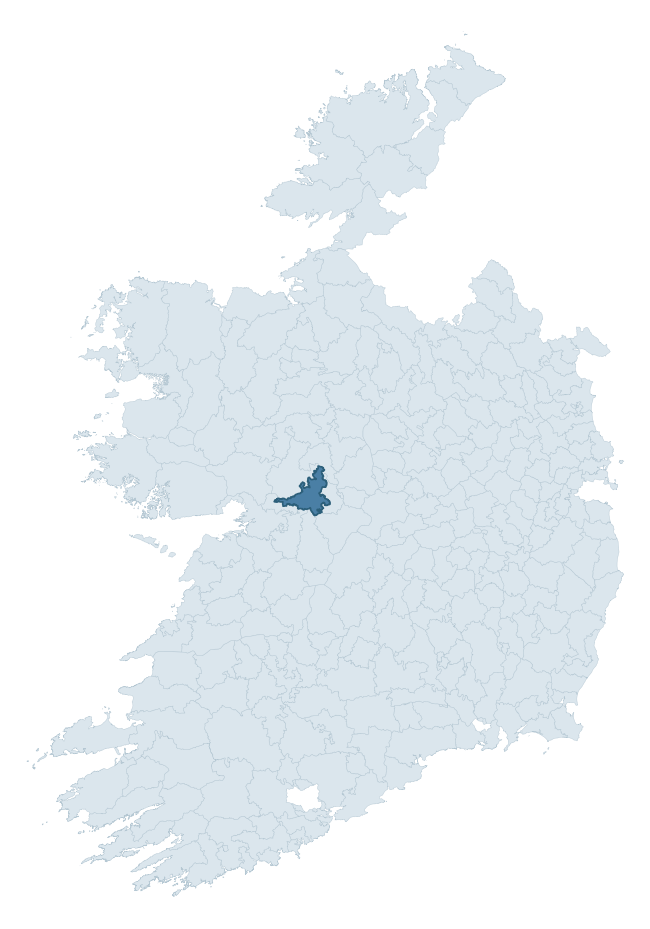
Where this barony sits in the Republic of Ireland
Geology and preservation
Bedrock geology shapes the landscape long before any settlement begins — controlling soil drainage, agricultural potential, the survival of upstanding monuments, and the preservation of buried archaeology. The figures below come from the Geological Survey Ireland 1:100,000 bedrock map.
The bedrock underlying Kilconnell is predominantly limestone (68% of the barony by area), laid down during the Carboniferous period (100% by area, around 359 to 299 million years ago). Limestone is the most heritage-rich bedrock in Ireland. It supports fertile, well-drained soils that favoured dense Early Medieval settlement and Norman manorial agriculture, and it weathers into karst features — sinkholes, caves, swallow holes, and souterrains — that frequently carry archaeology. Where peat overlies limestone, organic preservation can be exceptional. A substantial secondary geology of limestones (31%) adds further variety to the underlying landscape. The single largest mapped unit is the Lucan Formation (68% of the barony's bedrock). With only 2 distinct rock types mapped, the barony is geologically uniform compared to the rest of the Republic (8th percentile for diversity) — a single coherent bedrock landscape.
Rock type composition
Largest mapped unit: Lucan Formation (68% of the barony)
Placename evidence
Logainm records 34 heritage-diagnostic placenames for Kilconnell, drawn from townland and civil-parish names across the barony. The dominant stratum is pre-Christian and Early Medieval defensive — ráth-, lios-, dún-, and caiseal-prefixed names that mark Iron Age and early historic settlement. The leading diagnostic roots are lios- (11 — ringfort or enclosure), cill- (9 — church), and ráth- (5 — earthen ringfort). This is broadly in line with the ROI average of 30.7 heritage placenames per barony. The presence of multiple heritage strata side by side indicates layered occupation of the landscape across successive prehistoric and historic periods. Logainm records 220 placenames for Kilconnell (predominantly townland names). Of these, 34 (15%) carry one of the diagnostic Gaelic roots tracked above; the remainder draw on more generic landscape vocabulary that does not encode a heritage period.
Pre-Christian / Early Medieval Defensive
| Root | Count | Meaning |
|---|---|---|
| lios- | 11 | ringfort or enclosure |
| ráth- | 5 | earthen ringfort |
| dún- | 3 | hilltop or promontory fort |
Early Christian Ecclesiastical
| Root | Count | Meaning |
|---|---|---|
| cill- | 9 | church (early) |
| cillín- | 1 | unconsecrated burial ground |
| gráinseach- | 1 | monastic farm / grange |
| bile- | 1 | sacred tree / boundary marker |
Burial, Ritual, and Norse-Contact
| Root | Count | Meaning |
|---|---|---|
| carn- | 2 | cairn |
| uaimh- | 1 | cave / souterrain |
About this profile
Click any section below to expand.
What is a barony?
A barony is a historic administrative unit in Ireland, broadly equivalent to an English hundred. The 280 baronies used here are from the OSi 2019 National Statutory Boundaries (generalised 20m), covering the 26 counties of the Republic of Ireland. Baronies derive from the Norman period, were formalised in the 17th century, and have not been redrawn for statistical purposes. They vary enormously in area, from compact urban baronies in Dublin to vast upland baronies in Connacht, and should not be compared by raw site count without accounting for area differences.
What counts as a site?
This profile combines three distinct heritage registers, each with its own definition of what constitutes a recordable site:
- Archaeological sites (NMS). The National Monuments Service Sites and Monuments Record (SMR) catalogues every known archaeological monument or site of archaeological interest in the Republic, from prehistoric burial mounds and ringforts to medieval churches and post-medieval defensive works. Inclusion does not require legal protection — only that the site has been identified, surveyed, and assessed as having archaeological value. A separate subset of these sites lies within a recorded protection zone, which gives them statutory protection under the National Monuments Acts.
- Listed buildings (NIAH). The National Inventory of Architectural Heritage records buildings of architectural, historical, archaeological, artistic, cultural, scientific, social, or technical interest. Each surveyed structure is appraised on a five-tier scale: International, National, Regional, Local, and Record-Only. The NIAH appraisal is informational rather than strictly statutory, but it underpins local-authority Record of Protected Structures (RPS) listings.
- Heritage placenames (Logainm). Logainm is the authoritative database of Irish placenames maintained by the Placenames Branch. This profile applies a heritage-diagnostic classifier to the Irish-language form of each townland name, flagging roots that signal defensive sites (ráth-, lios-, dún-, caiseal-, cathair-), ecclesiastical foundations (cill-, teampall-, domhnach-, mainistir-), prehistoric burial-ritual features (tuaim-, carn-, leaba-), or Norse-contact settlement (gall-). Townlands without one of these diagnostic roots are not flagged here — they may still carry historical significance, but that significance is not encoded in the name itself.
Editorial principles
The narrative sections of this profile follow several explicit principles:
- Evidential. Every claim about this barony’s heritage character is anchored in the underlying register data. Where a site count, a placename count, or a percentile rank is cited, it is computed from the source datasets at export time, not estimated.
- Comparative. Counts and metrics are reported alongside their percentile rank against the other 279 ROI baronies. A barony with 50 ringforts in absolute terms could be unusually high or unusually low depending on its size and regional context; percentile ranking removes that ambiguity.
- Transparent on limits. Where a register has known coverage gaps, survey biases, or data-quality issues that affect this barony’s figures, the profile flags them rather than presenting the numbers as definitive.
- No interpretation beyond what the data supports. The narrative does not speculate about historical events, social dynamics, or cultural meaning beyond what the recorded heritage and placename evidence directly attests.
Data caveats and limits
- NMS Sites and Monuments Record is the product of survey campaigns conducted at different intensities across different counties and decades. Some baronies have been surveyed more thoroughly than others, and absolute counts should be read in that light. Sites destroyed by development before survey are typically not represented; sites in heavily forested or upland terrain are sometimes under-recorded.
- NIAH coverage is broadly complete for the Republic of Ireland but the survey was conducted on a rolling county-by-county basis, and the most recent appraisal date varies. Buildings demolished or substantially altered after their original survey may still appear in the register; conversely, recent buildings of merit may not yet have been appraised.
- Logainm classification applies a deliberately conservative pattern-matching approach to the Irish-language townland forms. The classifier prioritises true positives over recall: a townland may carry a heritage signal that the classifier doesn’t recognise, particularly where the diagnostic root has been heavily anglicised or where the townland name draws on a less common term. The 60,000+ townland records and ~9,800 classified placenames give a substantial signal at barony scale, but individual townland names should be checked against Logainm directly for definitive interpretation.
- Period attribution. The chronological distribution reflects only those NMS sites that carry a recognised period attribution in the source data. Sites listed as “Unknown” period are excluded from the dated subset.
- Boundary changes. Some baronies have undergone minor boundary adjustments since their 19th-century definition; the OSi 2019 generalised boundaries used here are the current statutory definition and may differ slightly from historical maps in border areas.
- Bedrock geology is mapped at 1:100,000 scale, which means local variation within a barony — small pockets of different rock type, mineral veins, alluvium overlying bedrock — is generalised. The dominant-system and rocktype figures are area-weighted, so a barony reading “70% Carboniferous limestone” may still contain small but archaeologically important pockets of older or younger rock. Around 3% of GSI polygons do not match the lexicon and contribute no rocktype or system attribution.
Data sources
- National Monuments Service — Sites and Monuments Record (SMR) https://data.gov.ie/dataset/national-monuments-service-archaeological-survey-of-ireland
- National Inventory of Architectural Heritage (NIAH) https://data.gov.ie/dataset/national-inventory-of-architectural-heritage-niah-national-dataset
- Logainm — Placenames Database of Ireland https://www.logainm.ie/
- Ordnance Survey Ireland — National Statutory Barony Boundaries 2019 https://data-osi.opendata.arcgis.com/
- EURODEM — European Digital Elevation Model https://www.mapsforeurope.org/datasets/euro-dem
- ESA WorldCover https://esa-worldcover.org/en
- Geological Survey Ireland — 1:100,000 Bedrock Geology https://www.gsi.ie/en-ie/data-and-maps/Pages/Bedrock.aspx
Explore more: Search any of the 280 ROI baronies, browse by historical province, or read the methodology and data sources for the full Republic of Ireland Heritage Tool.