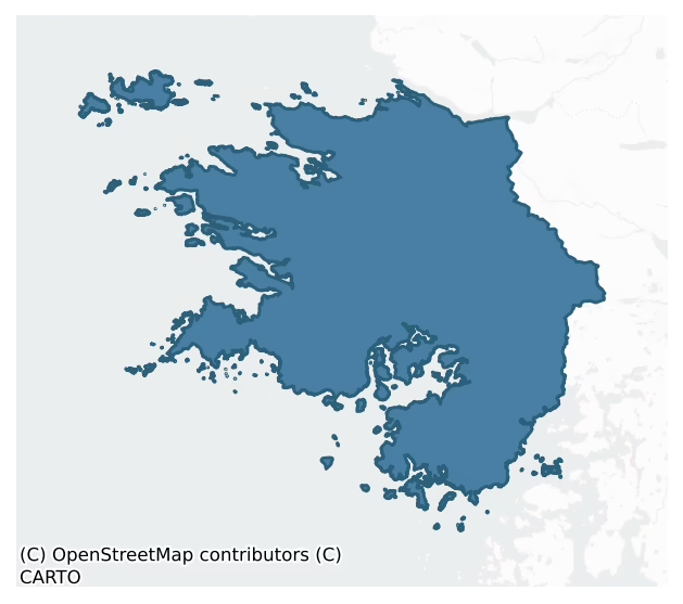
Ballynahinch is a barony of County Galway, in the historical province of Connacht (Irish: Baile na hInse), covering 790 km² of land. The barony records 812 NMS archaeological sites and 164 NIAH listed buildings, placing it at around the 14th percentile among 280 ROI baronies for sites per km². This means it is in the bottom fifth of all baronies for sites per km². Dated archaeological evidence runs from the Mesolithic through to the Modern, spanning 9 of 9 archaeological periods, placing the barony in the 94th percentile among 280 ROI baronies for chronological depth. This means it is in the top tenth of all baronies for chronological depth. The largest dated subset of recorded sites dates to the Early Medieval. Logainm flags 24 placenames in the barony as carrying a recognised heritage root; the largest share — around 54% — are names associated with pre-christian defensive.

Heritage at a glance
Percentile rankings throughout this profile compare each barony only against the other 279 Republic of Ireland baronies.
The recorded heritage of Ballynahinch
The National Monuments Service Sites and Monuments Record (SMR) is the statutory inventory of archaeological sites for the Republic of Ireland, maintained by the Department of Tourism, Culture, Arts, Gaeltacht, Sport and Media. Sites recorded here include earthworks, ringforts, megalithic tombs, ecclesiastical remains, and post-medieval features; not every record is legally protected, but each is registered as a monument of archaeological interest.
The National Monuments Service records 812 archaeological sites in Ballynahinch, putting it at the 14th percentile among 280 ROI baronies for sites per km². This means it is in the bottom fifth of all baronies for sites per km². A sparse recorded total of this kind in Ireland often reflects survey priority rather than genuine absence of past activity. Of these, 722 (89%) fall within a recorded monument protection zone. The record is dominated by ecclesiastical sites — churches, graveyards, and holy wells (201 sites, 25% of the total), with defensive sites forming a substantial secondary presence (93 sites, 11%). Cross-slab is the most prevalent type, making up 7% of the barony's recorded sites (59 records) — well above the ROI average of 5% across all baronies where this type occurs. Cross-slab is a stone slab inscribed with a cross, used as a grave-marker or memorial, dated pre-1200 AD. Other significant types include House – indeterminate date (59) and Enclosure (45). House – indeterminate date is a habitation building whose date cannot be determined from available evidence; Enclosure is a banked or ditched feature of uncertain type, used as a catch-all where the original function cannot be determined from surface evidence. Across the barony's 790 km², this gives a recorded density of 1.03 sites per km².
Most common monument types
Hover or tap a monument type to see its definition.
| Type | Count |
|---|---|
| Cross-slab a stone slab inscribed with a cross, used as a grave-marker or memorial, dated pre-1200 AD | 59 |
| House – indeterminate date a habitation building whose date cannot be determined from available evidence | 59 |
| Enclosure a banked or ditched feature of uncertain type, used as a catch-all where the original function cannot be determined from surface evidence | 45 |
| Ritual site – holy well a well or spring traditionally associated with a saint, often credited with healing properties; many trace earlier ritual origins but devotion is documented from the medieval period onwards | 41 |
| Graveyard a burial area associated with a church, in use from the medieval period onwards | 35 |
| Church a building used for public Christian worship, of any date from c. 500 AD onwards | 34 |
| Field boundary a continuous bank, wall or drain marking the limit of a field, of any date from the Neolithic onwards | 30 |
Chronological distribution
The dated archaeological record for Ballynahinch spans from the Mesolithic through to the Modern, with activity attested across 9 of 9 archaeological periods. This places Ballynahinch in the top 6% of ROI baronies for chronological depth — few baronies record evidence across as many distinct archaeological periods. Every period from earliest to latest is represented in the record — an unbroken sequence of dated activity across the full chronological span. Activity concentrates most heavily in the Early Medieval (147 sites, 34% of dated material), with the Iron Age forming a secondary peak (106 sites, 24%). A further 374 recorded sites (46% of the overall NMS register for the barony) carry no period attribution — appearing as 'Unknown' in the bar chart below. This typically reflects either records that pre-date the standardised period vocabulary or sites awaiting specialist dating review, rather than a genuine absence of chronological evidence.
Sample of recorded monuments
Show 25 sample monuments (of 812 total)
A representative sample of 25 recorded monuments drawn from the barony’s 812 total NMS entries. Sites within a recorded monument protection zone and rarer site types are prioritised so the list shows a meaningful cross-section rather than only the most common type. Each entry shows the official Sites and Monuments Record reference number and the description published by the National Monuments Service.
Cliff-edge fort
On a prominent headland to S of Renvyle Point. Known locally as Cathair an Dúin, it is an oval area (90m by 50m), sloping steeply to N from the cliff edge, defined by a massive revetted scarp (H 9m), a fosse (Wth 6-10m)…
On a prominent headland to S of Renvyle Point. Known locally as Cathair an Dúin, it is an oval area (90m by 50m), sloping steeply to N from the cliff edge, defined by a massive revetted scarp (H 9m), a fosse (Wth 6-10m) and an outer bank (Wth c. 3m, H 0.85m). A gap in the bank and a slight rise at about mid-point along the fosse may mark the position of an entrance causeway. In SE part of interior, close to the cliff edge, two grassy banks (E-W c. 5m) may represent the last vestiges of hut. The remains of a 2nd World War lookout stand at W end (info. from M. Casey). (Lynam 1922, 166-7; Killanin 1954, 99; Killanin and Duignan 1967, 413)
The above description is derived from the published 'Archaeological Inventory of County Galway Vol. I – West Galway'. Compiled by Paul Gosling (Dublin: Stationery Office, 1993).
Date of upload: 05 August 2010
Earthwork
On a steep N-facing slope overlooking the mouth of Ballynakill Harbour. A poorly preserved subrectangular structure (L 7.4m, Wth 1.3-1.6m), aligned WNW-ESE, and defined by set boulders (H 0.45m max.). The remains are…
On a steep N-facing slope overlooking the mouth of Ballynakill Harbour. A poorly preserved subrectangular structure (L 7.4m, Wth 1.3-1.6m), aligned WNW-ESE, and defined by set boulders (H 0.45m max.). The remains are insufficient to permit classification.
The above description is derived from the published 'Archaeological Inventory of County Galway Vol. I – West Galway'. Compiled by Paul Gosling (Dublin: Stationery Office, 1993).
Date of upload: 05 August 2010
Sundial
On a natural rise overlooking Cleggan Bay to the N and immediately to the SW of a roadway. Indicated and named 'Sun Dial' on the 1898 re-survey of the OS 6-inch map. No visible surface trace survives. It was probably…
On a natural rise overlooking Cleggan Bay to the N and immediately to the SW of a roadway. Indicated and named 'Sun Dial' on the 1898 re-survey of the OS 6-inch map. No visible surface trace survives. It was probably associated with the former coastguard station located to the SW.
Compiled by: Olive Alcock
Date of upload: 30 January 2023
Stone circle
On the summit of a hill overlooking the inner reaches of Streamstown Bay to SW. Two stones are aligned NE-SW and 1.75m apart. Both stones are of schist. The N stone is triangular in plan (H 1.1m) and S stone is…
On the summit of a hill overlooking the inner reaches of Streamstown Bay to SW. Two stones are aligned NE-SW and 1.75m apart. Both stones are of schist. The N stone is triangular in plan (H 1.1m) and S stone is rectangular (H 2.1m). A thin outlying monolith, irregular in plan (H 0.8m), lies 9m due SE of N stone. Lying beside it is another stone, also of schist (0.7m by 0.4m). Gibbons and Higgins (1988c) interpret this as a possible stone circle; it also has affinities with four-poster monuments. (Ormsby 1914; Kinahan 1872, 12; Ó Nualláin 1988, 197)
The above description is derived from the published 'Archaeological Inventory of County Galway Vol. I – West Galway'. Compiled by Paul Gosling (Dublin: Stationery Office, 1993).
Date of upload: 05 August 2010
Icehouse
In bogland on the S side of Kylemore valley, circa 200m to the SE of ‘Kylemore Farm Yard’. Only the roofless shell of this rectangular icehouse (NE-SW c. 10m; NW-SE c. 5m), which appears to be half buried in the bog,…
In bogland on the S side of Kylemore valley, circa 200m to the SE of ‘Kylemore Farm Yard’. Only the roofless shell of this rectangular icehouse (NE-SW c. 10m; NW-SE c. 5m), which appears to be half buried in the bog, survives. The NW wall is higher than the SE one indicating that the roof was steeply sloped. The doorway is in the NE wall. A line of beam slots running along the external face of the NW wall suggests a lean-to building was formerly built against it. When inspected the building was heavily overgrown with rhododendrons making access difficult.
Compiled by: Olive Alcock
Date of upload: 7 January 2018
Mausoleum
The Archaeological Survey of Ireland (ASI) is in the process of providing information on all monuments on The Historic Environment Viewer (HEV). Currently the information for this record has not been uploaded. To…
The Archaeological Survey of Ireland (ASI) is in the process of providing information on all monuments on The Historic Environment Viewer (HEV). Currently the information for this record has not been uploaded. To access available information for research purposes please make an appointment in advance with the Archive Unit (open Fridays 10.00 am – 5.00 pm), Department of Culture, Heritage and the Gaeltacht, The Custom House, Dublin 1 D01W6XO or email nmarchive@chg.gov.ie.
Rock shelter
In oak woodland interspersed with rhododendron, on an extremely steep S-facing slope. Named ‘Taghaillia’ (Cliff House) in Gothic script on the 1839 edition and 1898 resurvey of the OS 6-inch map. Recorded by Killanin…
In oak woodland interspersed with rhododendron, on an extremely steep S-facing slope. Named ‘Taghaillia’ (Cliff House) in Gothic script on the 1839 edition and 1898 resurvey of the OS 6-inch map. Recorded by Killanin and Duignan (1967, 345) as the ‘site of a prehistoric chamber tomb’, this consists of a massive overhanging rectangular boulder that appears to have been used as a rock shelter. A second large boulder supports the overhanging boulder on the E side. A drystone wall (L 5m; H 1.1m; Wth 1m) along the S and W forms a roughly subrectangular chamber (D 4m; Wth 2-3.5m). A series of rough steps lead through a gap (H 1.5m; Wth 0.6m) between the drystone-walling and the E supporting stone into the chamber. The central section of the chamber has been levelled and a rough flagged floor has been laid down. Another large boulder with a rock shelf on its E side is also visible in this area. A single cupmark (GA023-013001-) is visible on the rock shelf. A stone-lined fireplace was built against the W side of the chamber. This site is also known as ‘Scailp Johnny’, after Jonnie Gibbons who fled to this area after the collapse of the 1798 rebellion. The presence of the cupmark suggest that the shelter may have been used on and off since Neolithic times. The fireplace may date to works on Kylemore estate in the 1840s (pers. comm. M. Gibbons)
The uploaded image has been provided by M. Gibbons – view of access gap
Compiled by: Olive Alcock with information supplied by Michael…
Prison
The Archaeological Survey of Ireland (ASI) is in the process of providing information on all monuments on The Historic Environment Viewer (HEV). Currently the information for this record has not been uploaded. To…
The Archaeological Survey of Ireland (ASI) is in the process of providing information on all monuments on The Historic Environment Viewer (HEV). Currently the information for this record has not been uploaded. To access available information for research purposes please make an appointment in advance with the Archive Unit (open Fridays 10.00 am – 5.00 pm), Department of Culture, Heritage and the Gaeltacht, The Custom House, Dublin 1 D01W6XO or email nmarchive@chg.gov.ie.
Road – class 3 togher
The Archaeological Survey of Ireland (ASI) is in the process of providing information on all monuments on The Historic Environment Viewer (HEV). Currently the information for this record has not been uploaded. To…
The Archaeological Survey of Ireland (ASI) is in the process of providing information on all monuments on The Historic Environment Viewer (HEV). Currently the information for this record has not been uploaded. To access available information for research purposes please make an appointment in advance with the Archive Unit (open Fridays 10.00 am – 5.00 pm), Department of Culture, Heritage and the Gaeltacht, The Custom House, Dublin 1 D01W6XO or email nmarchive@chg.gov.ie.
Inscribed stone
Built into the outer face of what was originally the N gable of the fish curing station in Roundstone. An extension was subsequently built against the gable. An inscribed stone bearing the date 1731 and a number of…
Built into the outer face of what was originally the N gable of the fish curing station in Roundstone. An extension was subsequently built against the gable. An inscribed stone bearing the date 1731 and a number of incised lines was brought to the attention of Mr Tim Robinson (pers. comm. 1986), who forwarded a rubbing of it to Prof. E. Rynne, Dept. of Archaeology, UCG. Prof. Rynne (pers. comm. 1987) noted that the stone had been reused and that, apart from the date, the carving was difficult to interpret. He suggested that it might be a version of a schematic plough that was found on many graveslabs in Co. Galway or that it could be some sort of guild insignia, such as can be see on some of the armorial-bearing stones around Galway city.
Compiled by: Olive Alcock
Date of upload: 10 February 2023
Memorial stone
In a small tree plantation in bogland. This inscribed plaque was recorded by Robinson (1985, 20-21) who noted it below a pigeon loft in one of the gable walls of a building that had formerly been stables but was…
In a small tree plantation in bogland. This inscribed plaque was recorded by Robinson (1985, 20-21) who noted it below a pigeon loft in one of the gable walls of a building that had formerly been stables but was subsequently converted into an L-shaped house. The inscription reads:
'Remember as you pass Cecil Coulter and Louisa Alice his wife
who in this place 1918-1946 met sorrow and adversity with fortitude and
all who came their way with loving kindness and who in their day by
their vision and their labours made this wilderness a place of beauty.'
Their memorial tablet in Roundstone Protestant church (GA050-024001-), which mentions their son, Conrad Coryton, who was killed in World War I aged nineteen, may explain their sorrow (ibid.).
Compiled by: Olive Alcock
Date of upload: 16 February 2023
Robinson, T. 1985 Mapping South Connemara, parts 1-29, Cashal, Carna, Cill Chiarain. Roundstone.
Mound
The Archaeological Survey of Ireland (ASI) is in the process of providing information on all monuments on The Historic Environment Viewer (HEV). Currently the information for this record has not been uploaded. To…
The Archaeological Survey of Ireland (ASI) is in the process of providing information on all monuments on The Historic Environment Viewer (HEV). Currently the information for this record has not been uploaded. To access available information for research purposes please make an appointment in advance with the Archive Unit (open Fridays 10.00 am – 5.00 pm), Department of Culture, Heritage and the Gaeltacht, The Custom House, Dublin 1 D01W6XO or email nmarchive@chg.gov.ie.
Mine – copper
The Archaeological Survey of Ireland (ASI) is in the process of providing information on all monuments on The Historic Environment Viewer (HEV). Currently the information for this record has not been uploaded. To…
The Archaeological Survey of Ireland (ASI) is in the process of providing information on all monuments on The Historic Environment Viewer (HEV). Currently the information for this record has not been uploaded. To access available information for research purposes please make an appointment in advance with the Archive Unit (open Fridays 10.00 am – 5.00 pm), Department of Culture, Heritage and the Gaeltacht, The Custom House, Dublin 1 D01W6XO or email nmarchive@chg.gov.ie.
Industrial site
The Archaeological Survey of Ireland (ASI) is in the process of providing information on all monuments on The Historic Environment Viewer (HEV). Currently the information for this record has not been uploaded. To…
The Archaeological Survey of Ireland (ASI) is in the process of providing information on all monuments on The Historic Environment Viewer (HEV). Currently the information for this record has not been uploaded. To access available information for research purposes please make an appointment in advance with the Archive Unit (open Fridays 10.00 am – 5.00 pm), Department of Culture, Heritage and the Gaeltacht, The Custom House, Dublin 1 D01W6XO or email nmarchive@chg.gov.ie.
Mill – unclassified
In a densely wooded area. Named ‘Old Mill’ on the 1838 edition of the OS 6-inch map and depicted as a building, aligned NNE-SSW, spanning a small westerly flowing stream that flows into the nearby Salt Lake to the W. No…
In a densely wooded area. Named ‘Old Mill’ on the 1838 edition of the OS 6-inch map and depicted as a building, aligned NNE-SSW, spanning a small westerly flowing stream that flows into the nearby Salt Lake to the W. No visible surface trace of the mill was found. However, on the N side of the stream the possible course of the dried-up millrace (L 15m) was noted running parallel to it. Some drystone walling was evident along its course.
Compiled by: Olive Alcock
Date of upload: 13 February 2017
Cairn – clearance cairn
The Archaeological Survey of Ireland (ASI) is in the process of providing information on all monuments on The Historic Environment Viewer (HEV). Currently the information for this record has not been uploaded. To…
The Archaeological Survey of Ireland (ASI) is in the process of providing information on all monuments on The Historic Environment Viewer (HEV). Currently the information for this record has not been uploaded. To access available information for research purposes please make an appointment in advance with the Archive Unit (open Fridays 10.00 am – 5.00 pm), Department of Culture, Heritage and the Gaeltacht, The Custom House, Dublin 1 D01W6XO or email nmarchive@chg.gov.ie.
Shrine
In the middle of the older part of the burial ground (GA077-017—-). A roughly rectangular box-shaped structure (L 1.75m; Wth 1.35m; H 0.8m) is constructed of large natural boulders and roofed with smaller stones.…
In the middle of the older part of the burial ground (GA077-017—-). A roughly rectangular box-shaped structure (L 1.75m; Wth 1.35m; H 0.8m) is constructed of large natural boulders and roofed with smaller stones. Inside it loose scattered stones are visible on the ground as well as a piece of quartz and some coins. The structure is difficult to classify or date. It may be related to the slab or gabled shrines that are found on some early Christian sites or it may be of more recent date and related to some tradition associated with St Kieran. (Robinson 1985, 55)
Compiled by: Olive Alcock
Date of upload: 7 August 2019
Cairn – burial cairn
The Archaeological Survey of Ireland (ASI) is in the process of providing information on all monuments on The Historic Environment Viewer (HEV). Currently the information for this record has not been uploaded. To…
The Archaeological Survey of Ireland (ASI) is in the process of providing information on all monuments on The Historic Environment Viewer (HEV). Currently the information for this record has not been uploaded. To access available information for research purposes please make an appointment in advance with the Archive Unit (open Fridays 10.00 am – 5.00 pm), Department of Culture, Heritage and the Gaeltacht, The Custom House, Dublin 1 D01W6XO or email nmarchive@chg.gov.ie.
Religious house – Dominican friars
In an oval graveyard on seashore at mouth of An Abhainn Mhór. Site of a friary established in 1427 by Dominicans of Athenry (Gwynn and Hadcock 1970, 230). Destroyed in 16th C and its stones were reputedly used to build…
In an oval graveyard on seashore at mouth of An Abhainn Mhór. Site of a friary established in 1427 by Dominicans of Athenry (Gwynn and Hadcock 1970, 230). Destroyed in 16th C and its stones were reputedly used to build the castle at Ballynahinch (GA036-001001-). Reestablished in 18th C: a rectangular building, aligned E-W, appears on 1st ed. of OS 6-inch map. This has since been destroyed, but a raised area near centre of graveyard may mark its site. Present remains are of a small rectangular building (NNE-SSW; L 8.2m, Wth 4.8m) with doorway in W wall, narrow windows at either end of E wall, and recess in S. Late 16th-C in date according to Killanin (1954, 101) but it and the graveyard are probably 18-19th-C (see Hardiman 1846, 105-6). The site of a holy well is reputed to lie just outside graveyard to WSW. (O'Flanagan 1927a, Vol. 3, 126-34)
The above description is derived from the published 'Archaeological Inventory of County Galway Vol. I – West Galway'. Compiled by Paul Gosling (Dublin: Stationery Office, 1993).
Date of upload: 05 August 2010
Altar
The Archaeological Survey of Ireland (ASI) is in the process of providing information on all monuments on The Historic Environment Viewer (HEV). Currently the information for this record has not been uploaded. To…
The Archaeological Survey of Ireland (ASI) is in the process of providing information on all monuments on The Historic Environment Viewer (HEV). Currently the information for this record has not been uploaded. To access available information for research purposes please make an appointment in advance with the Archive Unit (open Fridays 10.00 am – 5.00 pm), Department of Culture, Heritage and the Gaeltacht, The Custom House, Dublin 1 D01W6XO or email nmarchive@chg.gov.ie.
Well
Located at the SE end of Cruach na Cara/St Macdara’s Island, c. 2.2m to the NE of a ruined house. This well (Wth 1m; L 0.3m; D 0.7m), dry at the time of inspection, may be a domestic well associated with the house. It…
Located at the SE end of Cruach na Cara/St Macdara’s Island, c. 2.2m to the NE of a ruined house. This well (Wth 1m; L 0.3m; D 0.7m), dry at the time of inspection, may be a domestic well associated with the house. It is roughly triangular in plan; the back wall consists of a massive granite boulder, while the side walls are constructed of smaller boulders. The base is overgrown with grass.
Compiled by: Olive Alcock
Date of upload: 6 June 2018
Pier/Jetty
The Archaeological Survey of Ireland (ASI) is in the process of providing information on all monuments on The Historic Environment Viewer (HEV). Currently the information for this record has not been uploaded. To…
The Archaeological Survey of Ireland (ASI) is in the process of providing information on all monuments on The Historic Environment Viewer (HEV). Currently the information for this record has not been uploaded. To access available information for research purposes please make an appointment in advance with the Archive Unit (open Fridays 10.00 am – 5.00 pm), Department of Culture, Heritage and the Gaeltacht, The Custom House, Dublin 1 D01W6XO or email nmarchive@chg.gov.ie.
Font
The Archaeological Survey of Ireland (ASI) is in the process of providing information on all monuments on The Historic Environment Viewer (HEV). Currently the information for this record has not been uploaded. To…
The Archaeological Survey of Ireland (ASI) is in the process of providing information on all monuments on The Historic Environment Viewer (HEV). Currently the information for this record has not been uploaded. To access available information for research purposes please make an appointment in advance with the Archive Unit (open Fridays 10.00 am – 5.00 pm), Department of Culture, Heritage and the Gaeltacht, The Custom House, Dublin 1 D01W6XO or email nmarchive@chg.gov.ie.
House – medieval
This much-collapsed building is on the S side of the SE entrance of the monastic enclosure (GA021-026022-) on High Island. It is built against the enclosure wall and is roughly subrectangular in plan. It varies in width…
This much-collapsed building is on the S side of the SE entrance of the monastic enclosure (GA021-026022-) on High Island. It is built against the enclosure wall and is roughly subrectangular in plan. It varies in width between 2.9m at its NW end and 3.8m at its SE end. The NE side is 3.7m long and the SW side is 4.3m. The doorway was in the SE wall. The width of the walls (c. 1-1.5m) suggests that roof was of timber rather than of corbelled stone. The size and location of the building, just outside the main entrance to the monastery, suggest that it was probably a guesthouse (White Marshall and Rourke 2000, 49-51).
Compiled by: Olive Alcock
Date of upload: 10 December 2015
Cross-slab
This cross-slab is c. 1.5m to the SSE of a holy well (GA021-026006-). It was previously located at the church (Wakeman 1839a). When Macalister (1896, 206, cross B) visited the island in 1896 it was leaning against the…
This cross-slab is c. 1.5m to the SSE of a holy well (GA021-026006-). It was previously located at the church (Wakeman 1839a). When Macalister (1896, 206, cross B) visited the island in 1896 it was leaning against the wall of the holy well. Described by Fisher (2014, 210, no. 21, Figs. 7.4, F.12) as a tapering garnet mica-schist slab (H 0.73m; Wth 0.54m; T 0.07m) which is decorated on both faces. The N face bears a linear cross that cuts through an irregular circle and ends with forked terminals. The outlines of the circle and terminals are repeated by firm grooves, giving the appearance of an outline cross. A hollow or weathered boss is enclosed by a curving groove in the upper left angle and this motif was probably repeated in the right angle. On the S face there is a linear cross with curving forked terminals. This cross is similar to that on the cross-slab (GA021-026049-) which was found at the base of the altar in the church (GA021-026014-) (ibid., 212). See also GA021-026007- for another similar cross-slab. (Wakeman 1891, 351, Pl. I, no. 6, 353 Pl. I, no. 51; White Marshall and Rourke 2000, 142, no. 2; Higgins 1987, vol. II, 294-5, no. 25)
Compiled by: Olive Alcock
Date of upload: 18 December 2015
Listed buildings
The National Inventory of Architectural Heritage (NIAH) is a state survey appraising buildings of architectural, historical, archaeological, artistic, cultural, scientific, social, or technical interest. Each surveyed structure receives a rating from International (the highest, for buildings of European importance) through National, Regional, Local, and Record-Only.
The NIAH records 164 listed buildings in Ballynahinch (70th percentile across ROI baronies). This includes 1 structure of International significance and 3 of National significance — buildings of the highest architectural and historic interest. The Republic holds 13 International-graded and 937 National-graded buildings in total, so this barony accounts for around 0% of the highest-tier national stock. Construction dates concentrate most heavily in the Victorian (1830-1900) period. The most-recorded building type is house (35 examples, 21% of the listed stock).
Terrain and environment
Mean elevation across the barony is 85m — the 46th percentile among 280 ROI baronies for elevation. This means it is in the lower half of all baronies for elevation. Elevation matters for heritage because higher-altitude baronies typically favour defensive monuments — ringforts and hilltop forts placed on prominent ground — while lowland baronies are more likely to carry the dense settlement and church networks of intensive agricultural landscapes. The barony reaches 724m at its highest point — a vertical span of more than 639m within its boundary, indicating significant topographic diversity. Mean slope is 7.4° — the 93rd percentile among 280 ROI baronies for slope. This means it is in the top tenth of all baronies for slope. This is consistently steep terrain by ROI standards, the kind of landscape that tends to preserve upstanding archaeological features well. Slope is a key control on both land use and archaeological preservation: steep ground resists ploughing and tends to preserve earthworks intact, while gentle slopes favour intensive cultivation that damages or destroys surface archaeology over time. Localised maximum slopes reach 26°, typical of stream-cut valleys, escarpments, or coastal bluffs within the wider landscape. The Topographic Wetness Index averages 9.8, the 16th percentile among 280 ROI baronies for wetness. This means it is in the bottom fifth of all baronies for wetness. This is well-drained ground by ROI standards — typical of upland or steeply-sloping country that sheds water rapidly. Drainage matters for heritage because poorly-drained ground preserves organic archaeology (wooden trackways, leather, textiles, and on rare occasions human remains) far better than free-draining soil; well-drained ground favours arable use but destroys organic material rapidly. The land-cover mosaic combines improved grassland (82%), woodland (8%), and open water (5%), giving a mixed agricultural and semi-natural landscape. In overall character, this is steeply-sloping terrain at modest elevation, with land use dominated by improved grassland.
Terrain measurements
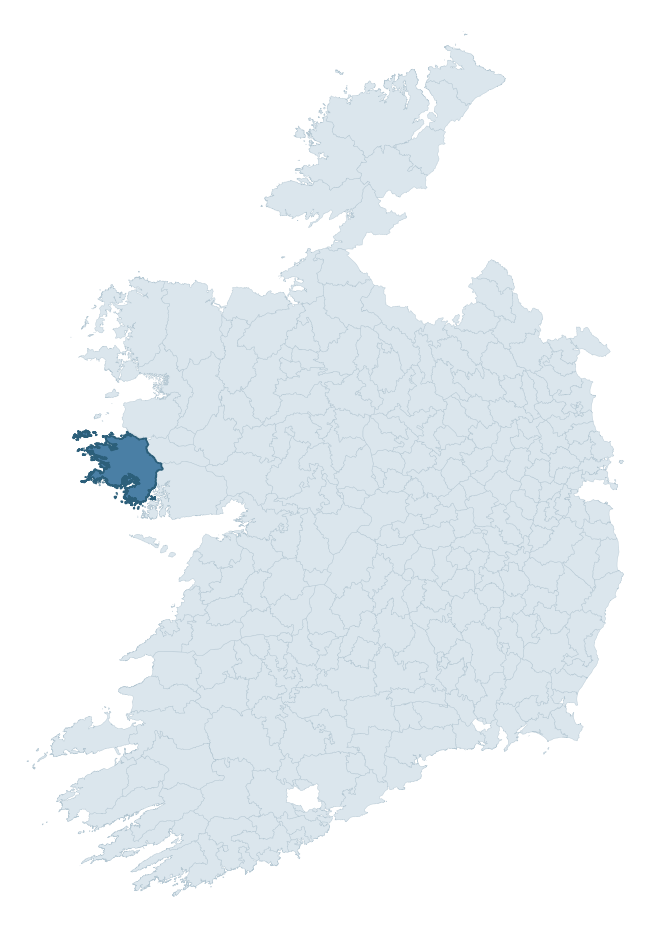
Where this barony sits in the Republic of Ireland
Geology and preservation
Bedrock geology shapes the landscape long before any settlement begins — controlling soil drainage, agricultural potential, the survival of upstanding monuments, and the preservation of buried archaeology. The figures below come from the Geological Survey Ireland 1:100,000 bedrock map.
The bedrock underlying Ballynahinch is predominantly pale quartzite (12% of the barony by area), with much of the rock dating to the Proterozoic period. With 20 distinct rock types mapped, the barony sits in the top third of ROI baronies for geological diversity (99th percentile) — typically a sign of complex tectonic history or coastal mosaics of differing rock units.
Rock type composition
Largest mapped unit: Bennabeola Quartzite Formation (12% of the barony)
Placename evidence
Logainm records 24 heritage-diagnostic placenames for Ballynahinch, drawn from townland and civil-parish names across the barony. The dominant stratum is pre-Christian and Early Medieval defensive — ráth-, lios-, dún-, and caiseal-prefixed names that mark Iron Age and early historic settlement. The leading diagnostic roots are dún- (7 — hilltop fort or promontory fort), cill- (5 — church), and ráth- (3 — earthen ringfort). This is broadly in line with the ROI average of 30.7 heritage placenames per barony. The presence of multiple heritage strata side by side indicates layered occupation of the landscape across successive prehistoric and historic periods. Logainm records 377 placenames for Ballynahinch (predominantly townland names). Of these, 24 (6%) carry one of the diagnostic Gaelic roots tracked above; the remainder draw on more generic landscape vocabulary that does not encode a heritage period.
Pre-Christian / Early Medieval Defensive
| Root | Count | Meaning |
|---|---|---|
| dún- | 7 | hilltop or promontory fort |
| ráth- | 3 | earthen ringfort |
| caiseal- | 2 | stone ringfort |
| lios- | 1 | ringfort or enclosure |
Early Christian Ecclesiastical
| Root | Count | Meaning |
|---|---|---|
| cill- | 5 | church (early) |
| cillín- | 1 | unconsecrated burial ground |
Burial, Ritual, and Norse-Contact
| Root | Count | Meaning |
|---|---|---|
| dumha- | 2 | mound |
| tuaim- | 1 | burial mound |
| carn- | 1 | cairn |
| leacht- | 1 | grave monument |
About this profile
Click any section below to expand.
What is a barony?
A barony is a historic administrative unit in Ireland, broadly equivalent to an English hundred. The 280 baronies used here are from the OSi 2019 National Statutory Boundaries (generalised 20m), covering the 26 counties of the Republic of Ireland. Baronies derive from the Norman period, were formalised in the 17th century, and have not been redrawn for statistical purposes. They vary enormously in area, from compact urban baronies in Dublin to vast upland baronies in Connacht, and should not be compared by raw site count without accounting for area differences.
What counts as a site?
This profile combines three distinct heritage registers, each with its own definition of what constitutes a recordable site:
- Archaeological sites (NMS). The National Monuments Service Sites and Monuments Record (SMR) catalogues every known archaeological monument or site of archaeological interest in the Republic, from prehistoric burial mounds and ringforts to medieval churches and post-medieval defensive works. Inclusion does not require legal protection — only that the site has been identified, surveyed, and assessed as having archaeological value. A separate subset of these sites lies within a recorded protection zone, which gives them statutory protection under the National Monuments Acts.
- Listed buildings (NIAH). The National Inventory of Architectural Heritage records buildings of architectural, historical, archaeological, artistic, cultural, scientific, social, or technical interest. Each surveyed structure is appraised on a five-tier scale: International, National, Regional, Local, and Record-Only. The NIAH appraisal is informational rather than strictly statutory, but it underpins local-authority Record of Protected Structures (RPS) listings.
- Heritage placenames (Logainm). Logainm is the authoritative database of Irish placenames maintained by the Placenames Branch. This profile applies a heritage-diagnostic classifier to the Irish-language form of each townland name, flagging roots that signal defensive sites (ráth-, lios-, dún-, caiseal-, cathair-), ecclesiastical foundations (cill-, teampall-, domhnach-, mainistir-), prehistoric burial-ritual features (tuaim-, carn-, leaba-), or Norse-contact settlement (gall-). Townlands without one of these diagnostic roots are not flagged here — they may still carry historical significance, but that significance is not encoded in the name itself.
Editorial principles
The narrative sections of this profile follow several explicit principles:
- Evidential. Every claim about this barony’s heritage character is anchored in the underlying register data. Where a site count, a placename count, or a percentile rank is cited, it is computed from the source datasets at export time, not estimated.
- Comparative. Counts and metrics are reported alongside their percentile rank against the other 279 ROI baronies. A barony with 50 ringforts in absolute terms could be unusually high or unusually low depending on its size and regional context; percentile ranking removes that ambiguity.
- Transparent on limits. Where a register has known coverage gaps, survey biases, or data-quality issues that affect this barony’s figures, the profile flags them rather than presenting the numbers as definitive.
- No interpretation beyond what the data supports. The narrative does not speculate about historical events, social dynamics, or cultural meaning beyond what the recorded heritage and placename evidence directly attests.
Data caveats and limits
- NMS Sites and Monuments Record is the product of survey campaigns conducted at different intensities across different counties and decades. Some baronies have been surveyed more thoroughly than others, and absolute counts should be read in that light. Sites destroyed by development before survey are typically not represented; sites in heavily forested or upland terrain are sometimes under-recorded.
- NIAH coverage is broadly complete for the Republic of Ireland but the survey was conducted on a rolling county-by-county basis, and the most recent appraisal date varies. Buildings demolished or substantially altered after their original survey may still appear in the register; conversely, recent buildings of merit may not yet have been appraised.
- Logainm classification applies a deliberately conservative pattern-matching approach to the Irish-language townland forms. The classifier prioritises true positives over recall: a townland may carry a heritage signal that the classifier doesn’t recognise, particularly where the diagnostic root has been heavily anglicised or where the townland name draws on a less common term. The 60,000+ townland records and ~9,800 classified placenames give a substantial signal at barony scale, but individual townland names should be checked against Logainm directly for definitive interpretation.
- Period attribution. The chronological distribution reflects only those NMS sites that carry a recognised period attribution in the source data. Sites listed as “Unknown” period are excluded from the dated subset.
- Boundary changes. Some baronies have undergone minor boundary adjustments since their 19th-century definition; the OSi 2019 generalised boundaries used here are the current statutory definition and may differ slightly from historical maps in border areas.
- Bedrock geology is mapped at 1:100,000 scale, which means local variation within a barony — small pockets of different rock type, mineral veins, alluvium overlying bedrock — is generalised. The dominant-system and rocktype figures are area-weighted, so a barony reading “70% Carboniferous limestone” may still contain small but archaeologically important pockets of older or younger rock. Around 3% of GSI polygons do not match the lexicon and contribute no rocktype or system attribution.
Data sources
- National Monuments Service — Sites and Monuments Record (SMR) https://data.gov.ie/dataset/national-monuments-service-archaeological-survey-of-ireland
- National Inventory of Architectural Heritage (NIAH) https://data.gov.ie/dataset/national-inventory-of-architectural-heritage-niah-national-dataset
- Logainm — Placenames Database of Ireland https://www.logainm.ie/
- Ordnance Survey Ireland — National Statutory Barony Boundaries 2019 https://data-osi.opendata.arcgis.com/
- EURODEM — European Digital Elevation Model https://www.mapsforeurope.org/datasets/euro-dem
- ESA WorldCover https://esa-worldcover.org/en
- Geological Survey Ireland — 1:100,000 Bedrock Geology https://www.gsi.ie/en-ie/data-and-maps/Pages/Bedrock.aspx
Explore more: Search any of the 280 ROI baronies, browse by historical province, or read the methodology and data sources for the full Republic of Ireland Heritage Tool.