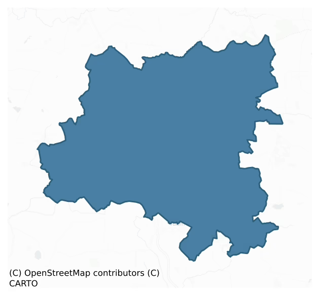
Dunmore is a barony of County Galway, in the historical province of Connacht (Irish: Dún Mór), covering 288 km² of land. The barony records 788 NMS archaeological sites and 57 NIAH listed buildings, placing it at around the 76th percentile among 280 ROI baronies for sites per km². This means it is in the top third of all baronies for sites per km². Dated archaeological evidence runs from the Neolithic through to the Modern, spanning 8 of 9 archaeological periods, placing the barony in the 64th percentile among 280 ROI baronies for chronological depth. This means it is in the upper half of all baronies for chronological depth. The largest dated subset of recorded sites dates to the Early Medieval. Logainm flags 41 placenames in the barony as carrying a recognised heritage root; the largest share — around 44% — are names associated with pre-christian defensive.

Heritage at a glance
Percentile rankings throughout this profile compare each barony only against the other 279 Republic of Ireland baronies.
The recorded heritage of Dunmore
The National Monuments Service Sites and Monuments Record (SMR) is the statutory inventory of archaeological sites for the Republic of Ireland, maintained by the Department of Tourism, Culture, Arts, Gaeltacht, Sport and Media. Sites recorded here include earthworks, ringforts, megalithic tombs, ecclesiastical remains, and post-medieval features; not every record is legally protected, but each is registered as a monument of archaeological interest.
The National Monuments Service records 788 archaeological sites in Dunmore, putting it at the 76th percentile among 280 ROI baronies for sites per km². This means it is in the top third of all baronies for sites per km². Of these, 706 (90%) fall within a recorded monument protection zone. The dominant category is defensive sites — ringforts, enclosures, hillforts, and stone forts (440 sites, 56% of the record). Ringfort – rath is the most prevalent type, making up 33% of the barony's recorded sites (263 records) — well above the ROI average of 20% across all baronies where this type occurs. Ringfort – rath is an earthen ringfort enclosed by a bank and external ditch — the most common Early Medieval farmstead, broadly dated 500–1000 AD. Other significant types include Enclosure (66) and Children's burial ground (56). Enclosure is a banked or ditched feature of uncertain type, used as a catch-all where the original function cannot be determined from surface evidence; Children's burial ground is an unconsecrated medieval and early-modern burial ground for unbaptised or stillborn children, often called a cillín or ceallúnach. Across the barony's 288 km², this gives a recorded density of 2.74 sites per km².
Most common monument types
Hover or tap a monument type to see its definition.
| Type | Count |
|---|---|
| Ringfort – rath an earthen ringfort enclosed by a bank and external ditch — the most common Early Medieval farmstead, broadly dated 500–1000 AD | 263 |
| Enclosure a banked or ditched feature of uncertain type, used as a catch-all where the original function cannot be determined from surface evidence | 66 |
| Children's burial ground an unconsecrated medieval and early-modern burial ground for unbaptised or stillborn children, often called a cillín or ceallúnach | 56 |
| Souterrain an underground stone-built passage and chamber, generally Early Medieval and often associated with ringforts as a defensive or storage feature | 36 |
| Earthwork an unclassified earthen structure with no diagnostic features that allow a more specific classification | 22 |
| Church a building used for public Christian worship, of any date from c. 500 AD onwards | 19 |
Chronological distribution
The dated archaeological record for Dunmore spans from the Neolithic through to the Modern, with activity attested across 8 of 9 archaeological periods. Every period from earliest to latest is represented in the record — an unbroken sequence of dated activity across the full chronological span. Activity concentrates most heavily in the Early Medieval (331 sites, 57% of dated material), with the Iron Age forming a secondary peak (153 sites, 27%). A further 212 recorded sites (27% of the overall NMS register for the barony) carry no period attribution — appearing as 'Unknown' in the bar chart below. This typically reflects either records that pre-date the standardised period vocabulary or sites awaiting specialist dating review, rather than a genuine absence of chronological evidence.
Sample of recorded monuments
Show 25 sample monuments (of 788 total)
A representative sample of 25 recorded monuments drawn from the barony’s 788 total NMS entries. Sites within a recorded monument protection zone and rarer site types are prioritised so the list shows a meaningful cross-section rather than only the most common type. Each entry shows the official Sites and Monuments Record reference number and the description published by the National Monuments Service.
Water mill – horizontal-wheeled
On S bank of the Dalgan River, to ENE of a trackway (GA004-015—-). In 1971, a long plank of wood (L 1.53m), mortised at each end, and a pointed wooden stake were found in cutaway bog. The plank is probably part of a…
On S bank of the Dalgan River, to ENE of a trackway (GA004-015—-). In 1971, a long plank of wood (L 1.53m), mortised at each end, and a pointed wooden stake were found in cutaway bog. The plank is probably part of a horizontal watermill (Topgr. Files, NMI).
The above description is derived from the published 'Archaeological Inventory of County Galway Vol. II – North Galway'. Compiled by Olive Alcock, Kathy de hÓra and Paul Gosling (Dublin: Stationery Office, 1999).
Date of upload: 05 August 2010
Standing stone
On N-facing slope of a low rise in undulating grassland. An irregularly shaped standing stone of sandstone (H 1.6m). The numerous small depressions on its surface are probably due to erosion. A ringfort (GA044-019—-)…
On N-facing slope of a low rise in undulating grassland. An irregularly shaped standing stone of sandstone (H 1.6m). The numerous small depressions on its surface are probably due to erosion. A ringfort (GA044-019—-) lies 135m to NW.
The above description is derived from the published 'Archaeological Inventory of County Galway Vol. II – North Galway'. Compiled by Olive Alcock, Kathy de hÓra and Paul Gosling (Dublin: Stationery Office, 1999).
Date of upload: 05 August 2010
Altar
In the Inventory this 'Altar' is described under the entry Ecclesiastical Remains – No. 3321.
Hillfort
Encompassing the summit of Belmont Hill in undulating grassland. A large subcircular enclosure (N-S 170m, E-W 150m), in fair condition, defined by a bank and external fosse. Traces of an outer bank are visible beneath…
Encompassing the summit of Belmont Hill in undulating grassland. A large subcircular enclosure (N-S 170m, E-W 150m), in fair condition, defined by a bank and external fosse. Traces of an outer bank are visible beneath the modern stone wall which encloses the hill summit and Raftery (1976, 90) also noted traces of an outer fosse especially at S. An internal stone-facing is visible along the inner bank at E. There are entrances at S (Wth 5.5m) and W (Wth 3m), both with corresponding causeways across the fosse: Raftery (ibid., 90-91) suggests that the latter may be modern. A graveyard (GA015-016001-) is associated. (Costello 1902b, 109; Knox 1911a, 109)
The above description is derived from the published 'Archaeological Inventory of County Galway Vol. II – North Galway'. Compiled by Olive Alcock, Kathy de hÓra and Paul Gosling (Dublin: Stationery Office, 1999).
Date of upload: 05 August 2010
Gatehouse
In level grassland within the former Blindwell Demesne. All that survives are the remains of an E-facing pointed arch gateway (Wth 1.8m) with two hanging eyes: possibly the entrance to the bawn. This is flanked on S by…
In level grassland within the former Blindwell Demesne. All that survives are the remains of an E-facing pointed arch gateway (Wth 1.8m) with two hanging eyes: possibly the entrance to the bawn. This is flanked on S by a section of contemporary wall (L c. 2m) within which are a number of gun loops. Traces of a barrel vault are visible towards the top of this wall. This is matched by a corresponding bulge in the pebble-dashed wall of the modern stables which flank the gateway to N. These remains suggest that the gateway formed part of a vaulted two-storey structure; possibly a small gate-tower. Incorporated into the adjoining field walls are numerous cut-stone fragments, including the top of a decorated ogee-headed window.
The above description is derived from the published 'Archaeological Inventory of County Galway Vol. II – North Galway'. Compiled by Olive Alcock, Kathy de hÓra and Paul Gosling (Dublin: Stationery Office, 1999).
Date of upload: 05 August 2010
Icehouse
The Archaeological Survey of Ireland (ASI) is in the process of providing information on all monuments on The Historic Environment Viewer (HEV). Currently the information for this record has not been uploaded. To…
The Archaeological Survey of Ireland (ASI) is in the process of providing information on all monuments on The Historic Environment Viewer (HEV). Currently the information for this record has not been uploaded. To access available information for research purposes please make an appointment in advance with the Archive Unit (open Fridays 10.00 am – 5.00 pm), Department of Culture, Heritage and the Gaeltacht, The Custom House, Dublin 1 D01W6XO or email nmarchive@chg.gov.ie.
Settlement deserted – medieval
In pastureland immediately to the SE side of a roughly NE-SW running esker ridge. A series of earthworks, covering an area of c. 367m N-S by c. 320m NE-SW and visible across two fields, comprise a number of rectangular…
In pastureland immediately to the SE side of a roughly NE-SW running esker ridge. A series of earthworks, covering an area of c. 367m N-S by c. 320m NE-SW and visible across two fields, comprise a number of rectangular and irregular earthen field banks and enclosures, possible house sites and a routeway. The banks vary in base width from 2m to 4m and their maximum height is 1m. Traces of old cultivation ridges are visible in the N half of the complex. The earthworks were formerly overlooked by ‘Tolendal Castle’ (GA016-034—-), the site of which is located near the SW end of the esker. They may have extended further to the NE where some may have been destroyed when the road bypassing the Tullenadaly Cross Roads junction was built (SMR file, 1984). The N17 has subsequently been constructed to the W of them. It is possible that the earthworks are the remains of a medieval settlement which was associated with the castle, both of which are recorded in 1618 as part of the holdings of Isaac Lally: ‘the castle, town and lands of Tullendally’ (Cal. pat. Rolls Ire., Jas I). A possible church (GA016-138—-) may also be associated. (Alcock et al. 1999, 421)
The following images have been uploaded:
GA016-035—-_01 General view from E; esker visible right background.jpg
GA016-035—-_02 General view from E.jpg
GA016-035—-_03 Looking NE.jpg
GA016-035—-_04 Looking SE.jpg
Compiled by: Olive Alcock
Date of upload: 4 February 2022
Castle – motte and bailey
In gently undulating grassland, overlooking bogland and a stream to S. Poorly preserved, partially natural, flat-topped earthen mound (14.5m N-S, 10.6m E-W) surrounded by an egg-shaped enclosure (40m N-S, E-W 28m)…
In gently undulating grassland, overlooking bogland and a stream to S. Poorly preserved, partially natural, flat-topped earthen mound (14.5m N-S, 10.6m E-W) surrounded by an egg-shaped enclosure (40m N-S, E-W 28m) defined by a fosse. Traces of an outer bank survive at SSW. A castle (GA016-056002-) occupied the top of the mound. (Neary 1914, 124, no. 150)
The above description is derived from the published 'Archaeological Inventory of County Galway Vol. II – North Galway'. Compiled by Olive Alcock, Kathy de hÓra and Paul Gosling (Dublin: Stationery Office, 1999).
Date of upload: 05 August 2010
Gate lodge
The Archaeological Survey of Ireland (ASI) is in the process of providing information on all monuments on The Historic Environment Viewer (HEV). Currently the information for this record has not been uploaded. To…
The Archaeological Survey of Ireland (ASI) is in the process of providing information on all monuments on The Historic Environment Viewer (HEV). Currently the information for this record has not been uploaded. To access available information for research purposes please make an appointment in advance with the Archive Unit (open Fridays 10.00 am – 5.00 pm), Department of Culture, Heritage and the Gaeltacht, The Custom House, Dublin 1 D01W6XO or email nmarchive@chg.gov.ie.
Inscribed stone (present location)
This record was formerly classified as ‘Ogham stone (present location)’. This was based on local information provided to survey staff in 1984 and 1990 which recorded that the stone had been broken in two with one half…
This record was formerly classified as ‘Ogham stone (present location)’. This was based on local information provided to survey staff in 1984 and 1990 which recorded that the stone had been broken in two with one half buried and the other half lost (SMR file). As the so-called ogham markings have never been verified as genuine this stone cannot be classified with certainty as an ogham stone and a proper elucidation of the monument must await further investigation. The stone was supposedly located c. 400m north-west of this position (see GA016-134—-).
Compiled by: Paul Walsh
Date of upload: 14 November 2016
Historic town
At a fording point on the Sinking River, 1km downstream from Dunmore Castle (GA017-069—-). Like the castle, the borough was probably founded by Piers de Bermingham sometimes before his death in 1249 (Bradley and Dunne…
At a fording point on the Sinking River, 1km downstream from Dunmore Castle (GA017-069—-). Like the castle, the borough was probably founded by Piers de Bermingham sometimes before his death in 1249 (Bradley and Dunne 1992, 65-6). The above authors (ibid., 67) suggest that it may have been 'concentrated' on N side of the river. A reference to the construction of a town wall exists as early as 1280 (Graham 1972, 14), though no visible surface trace of its line or fabric survives. However, the modern street plan, plot pattern and street names — High St., Gater St. — reflect a long urban ancestry. The surviving monuments comprise the Augustinian friary (GA017-005001-), in Barrack St., and the 'Abbey' (GA017-001001-), on N side of Chapel St.; probably the site of the medieval parish church. There is also an enigmatic earthwork (GA017-004—-), marked 'Mote' on OS 6-inch map, on E outskirts. (Neary 1914, 101-4; Holland 1988, 77-81)
The above description is derived from the published 'Archaeological Inventory of County Galway Vol. II – North Galway'. Compiled by Olive Alcock, Kathy de hÓra and Paul Gosling (Dublin: Stationery Office, 1999).
Date of upload: 05 August 2010
Water mill – vertical-wheeled
The Archaeological Survey of Ireland (ASI) is in the process of providing information on all monuments on The Historic Environment Viewer (HEV). Currently the information for this record has not been uploaded. To…
The Archaeological Survey of Ireland (ASI) is in the process of providing information on all monuments on The Historic Environment Viewer (HEV). Currently the information for this record has not been uploaded. To access available information for research purposes please make an appointment in advance with the Archive Unit (open Fridays 10.00 am – 5.00 pm), Department of Culture, Heritage and the Gaeltacht, The Custom House, Dublin 1 D01W6XO or email nmarchive@chg.gov.ie.
Castle – hall-house
In NW corner of a large enclosure (GA017-069001-). This Nat. Mon. consists of a massive multiperiod castle which Harbison (1975, 91) suggests dates from the early 14th C. However, the lower sections may incorporate part…
In NW corner of a large enclosure (GA017-069001-). This Nat. Mon. consists of a massive multiperiod castle which Harbison (1975, 91) suggests dates from the early 14th C. However, the lower sections may incorporate part of the original castle built by de Bermingham c. 1225. At any rate, it was evidently rebuilt in the late 16th or early 17th C when an extra floor was added. The remains comprise the sharply battered shell of a rectangular keep (L 14m, Wth 8.2m), five storeys in height. The original castle was probably of two or three storeys with a hall at 1st-floor level. The original doorway (now robbed) is at S end of E wall at 1st-floor level. Two beam holes which supported the framework for an external stairs are visible below it. A later doorway inserted directly below this, on ground floor, now provides access. A broken spiral stairs in NE angle connects ground and 1st floors. There is no evidence of a stone vault. Traces of the line of gables are visible internally on E and W walls between 2nd/3rd floor. Fireplaces occur in N wall on 1st and 2nd floors, in E gable on 2nd and 3rd floors, and in W gable on 3rd floor. There is a garderobe in NW angle on 1st floor. Slop-stones occur on N, E and S walls at parapet level. The gables rise inside the parapets and while the chimney breast on W gable is on the outer face, that on E gable is on the inner face The surviving windows include an oculis on 3rd floor of N wall, two mullioned windows with hood mouldings in S wall and…
Hilltop enclosure
On a low hill surrounded by flat bogland. An oval enclosure (E-W 112m, N-S 95m), in fair condition, defined by a bank/scarp, an intervening fosse and outer bank. The inner bank survives as a low denuded bank/scarp (H c.…
On a low hill surrounded by flat bogland. An oval enclosure (E-W 112m, N-S 95m), in fair condition, defined by a bank/scarp, an intervening fosse and outer bank. The inner bank survives as a low denuded bank/scarp (H c. 0.3m max.) except from N to NE where an attempt was made to level it, and at W where a disused silage pit now stands. The fosse is shallow (Wth 4-8.5m) but intact save at W, and at WNW where it is overlain by a modern causeway. The outer bank (Wth 2.3m, H 1.3m max.) is incorporated into a modern field boundary. A CBG (GA017-071001-) lies in NE quadrant of the interior and a probable souterrain (GA017-071002-) is also associated. While the presence of the CBG and probable souterrain might indicate an early ecclesiastical connection, the size and location of the enclosure suggest a prehistoric origin. (Neary 1914, 113-14, no. 139)
The above description is derived from the published 'Archaeological Inventory of County Galway Vol. II – North Galway'. Compiled by Olive Alcock, Kathy de hÓra and Paul Gosling (Dublin: Stationery Office, 1999).
Date of upload: 05 August 2010
Platform
In pastureland. Marked on 1st ed. of OS 6-inch map as a small circular earthwork (D c. 20m) surmounted by a trigonometrical station. Along with GA017-145—-, it was described by Neary (1914, 116, no. 156) as 'circular,…
In pastureland. Marked on 1st ed. of OS 6-inch map as a small circular earthwork (D c. 20m) surmounted by a trigonometrical station. Along with GA017-145—-, it was described by Neary (1914, 116, no. 156) as 'circular, earthen raths … now mere mounds 6 ft. [1.82m] above roadway in Prospect demesne'. What is visible is a small circular platform (D 8.9m), in fair condition, defined by a scarp (H 1.2m max.). There is a small circular grassed-over heap of stone (D 1.2m, H 0.2m) in N half of the interior: possibly a house or a landscape feature.
The above description is derived from the published 'Archaeological Inventory of County Galway Vol. II – North Galway'. Compiled by Olive Alcock, Kathy de hÓra and Paul Gosling (Dublin: Stationery Office, 1999).
Date of upload: 05 August 2010
Dovecote
The Archaeological Survey of Ireland (ASI) is in the process of providing information on all monuments on The Historic Environment Viewer (HEV). Currently the information for this record has not been uploaded. To…
The Archaeological Survey of Ireland (ASI) is in the process of providing information on all monuments on The Historic Environment Viewer (HEV). Currently the information for this record has not been uploaded. To access available information for research purposes please make an appointment in advance with the Archive Unit (open Fridays 10.00 am – 5.00 pm), Department of Culture, Heritage and the Gaeltacht, The Custom House, Dublin 1 D01W6XO or email nmarchive@chg.gov.ie.
Round tower
Standing 5m W of the church (GA029-017002-) on W boundary wall of the graveyard. This ruined circular tower (D 4.8m, H 16.5m), which stands on a plinth, was a least three storeys in height. It is built of roughly cut…
Standing 5m W of the church (GA029-017002-) on W boundary wall of the graveyard. This ruined circular tower (D 4.8m, H 16.5m), which stands on a plinth, was a least three storeys in height. It is built of roughly cut and regularly coursed limestone save for the plain round-headed doorway on NE side which is of sandstone. This stands 4.55m above ground level. There are traces of a window on NNE side in the broken wall just above 2nd-floor level. (Kelly 1901b; O'Flanagan 1927, Vol. 1, 92-5; Barrow 1979, 97-8)
The above description is derived from the published 'Archaeological Inventory of County Galway Vol. II – North Galway'. Compiled by Olive Alcock, Kathy de hÓra and Paul Gosling (Dublin: Stationery Office, 1999).
Date of upload: 05 August 2010
The monument was taken into Ownership under the National Monuments Acts 1930 to 2014 – National Monument 48.
Memorial stone
The Archaeological Survey of Ireland (ASI) is in the process of providing information on all monuments on The Historic Environment Viewer (HEV). Currently the information for this record has not been uploaded. To…
The Archaeological Survey of Ireland (ASI) is in the process of providing information on all monuments on The Historic Environment Viewer (HEV). Currently the information for this record has not been uploaded. To access available information for research purposes please make an appointment in advance with the Archive Unit (open Fridays 10.00 am – 5.00 pm), Department of Culture, Heritage and the Gaeltacht, The Custom House, Dublin 1 D01W6XO or email nmarchive@chg.gov.ie.
Cross – Market cross
The Archaeological Survey of Ireland (ASI) is in the process of providing information on all monuments on The Historic Environment Viewer (HEV). Currently the information for this record has not been uploaded. To…
The Archaeological Survey of Ireland (ASI) is in the process of providing information on all monuments on The Historic Environment Viewer (HEV). Currently the information for this record has not been uploaded. To access available information for research purposes please make an appointment in advance with the Archive Unit (open Fridays 10.00 am – 5.00 pm), Department of Culture, Heritage and the Gaeltacht, The Custom House, Dublin 1 D01W6XO or email nmarchive@chg.gov.ie.
Cross – Tau cross
Within a children’s burial ground (GA005-035007-) immediately to the N of a church (GA005-035002-). This roughly worked and undecorated tau cross (H 0.67m; Wth 0.49m; T 0.09m) was recorded by Higgins (1987, ii, 396, no.…
Within a children’s burial ground (GA005-035007-) immediately to the N of a church (GA005-035002-). This roughly worked and undecorated tau cross (H 0.67m; Wth 0.49m; T 0.09m) was recorded by Higgins (1987, ii, 396, no. 116). It is set upright and appears to have been reused as a grave-marker. A cross-slab (GA005-035005-) has also been reused as a grave-marker.
The above description is derived from the published 'Archaeological Inventory of County Galway Vol. II – North Galway'. Compiled by Olive Alcock, Kathy de hÓra and Paul Gosling (Dublin: Stationery Office, 1999). In certain instances the entries have been revised and updated in the light of recent research.
Updated by: Olive Alcock
Date of revised upload: 28 May 2018
Chapel
In Kilconly village, c. 50m S of an ecclesiastical building (GA015-013—-). Marked on 1st ed. of OS 6-inch map as rectangular chapel, aligned E-W. No visible surface trace survives apart from a number of mortared…
In Kilconly village, c. 50m S of an ecclesiastical building (GA015-013—-). Marked on 1st ed. of OS 6-inch map as rectangular chapel, aligned E-W. No visible surface trace survives apart from a number of mortared stones.
The above description is derived from the published 'Archaeological Inventory of County Galway Vol. II – North Galway'. Compiled by Olive Alcock, Kathy de hÓra and Paul Gosling (Dublin: Stationery Office, 1999).
Date of upload: 05 August 2010
Cross – High cross
Marked on OS 6-inch maps 65m WNW of a church (GA016-013001-) and graveyard, this high cross now lies against the outer face of W wall of the latter (see GA016-013008- for present location). The original site appears to…
Marked on OS 6-inch maps 65m WNW of a church (GA016-013001-) and graveyard, this high cross now lies against the outer face of W wall of the latter (see GA016-013008- for present location). The original site appears to have been on the summit of a hillock (Topgr. Files, NMI) but this has since been quarried away. It consists of the unfinished head of a granite cross (Wth 1.2m, H 1.4m) some 0.25m in thickness. The short arms appear to spring from a small solid ring. Both the arms and shaft are decorated with volutes. One face bears the raised outline of a figure with a tilted head and drooping outstretched arms; evidently an unfinished figure of Christ. (Neary 1914, 125, no. 76; Crawford 1918, 176; O'Flanagan 1927, Vol. 1, 28; Higgins 1987, 278, P1. 46b; Harbison 1992, 9-10, no. 3) The cross is now affixed to the graveyard wall (pers. comm. Dr. Christy Cunniffe, 2013)
The above description is derived from the published 'Archaeological Inventory of County Galway Vol. II – North Galway'. Compiled by Olive Alcock, Kathy de hÓra and Paul Gosling (Dublin: Stationery Office, 1999).
Date of upload: 05 August 2010
Road – road/trackway
In pastureland, c. 60m to the E of Kilclooy Castle (GA016-062001-). Aerial reconnaissance (CUCAP ATF 57) in July 1967 brought to light a field system (GA016-062002-) and an old roadway to its E. The roadway ran roughly…
In pastureland, c. 60m to the E of Kilclooy Castle (GA016-062001-). Aerial reconnaissance (CUCAP ATF 57) in July 1967 brought to light a field system (GA016-062002-) and an old roadway to its E. The roadway ran roughly SSE-NNW (L c. 140m) and then kinked to a more NNE direction (L c. 100m) and continued on to the old Galway-Tuam road. On inspection in November 1990, only traces (Wth 5m) of it were visible. Current aerial imagery (OSi DigitalGlobe 2011-2013) indicates that the re-aligned N17 cuts through its N limits.
Compiled by: Olive Alcock
Date of upload: 6 December 2022
Mass-rock
The Archaeological Survey of Ireland (ASI) is in the process of providing information on all monuments on The Historic Environment Viewer (HEV). Currently the information for this record has not been uploaded. To…
The Archaeological Survey of Ireland (ASI) is in the process of providing information on all monuments on The Historic Environment Viewer (HEV). Currently the information for this record has not been uploaded. To access available information for research purposes please make an appointment in advance with the Archive Unit (open Fridays 10.00 am – 5.00 pm), Department of Culture, Heritage and the Gaeltacht, The Custom House, Dublin 1 D01W6XO or email nmarchive@chg.gov.ie.
Ringfort – rath
In pastureland on a S-facing slope, some 150m to the WNW of a Kilcloony Castle (GA016-062001-). This poorly preserved circular rath (D 57m) is defined by two banks and an intervening fosse. The inner bank (Wth 4.5m;…
In pastureland on a S-facing slope, some 150m to the WNW of a Kilcloony Castle (GA016-062001-). This poorly preserved circular rath (D 57m) is defined by two banks and an intervening fosse. The inner bank (Wth 4.5m; int. H 0.2m; ext. H 0.9m) is only visible at N and SW; elsewhere a scarp forms the enclosing element. The fosse (Wth 2.8m) and outer bank (Wth 2m; int. H 0.2m; ext. H 0.55m) survive all round except at SE or NW. FitzPatrick (2019, 24) noted field boundaries, on LiDAR imagery, extending off the rath at S, SW and NW. Segments of further curving field banks were also visible on the imagery in the field further to the N and S of the rath, and also in the field adjoining it to the E (see GA016-062002-). They may be part of a field system (GA016-064001-) associated with the rath. (CUCAP ATF 57; Alcock et al. 1999, 114)
Compiled by: Olive Alcock
Date of upload: 7 December 2022
Listed buildings
The National Inventory of Architectural Heritage (NIAH) is a state survey appraising buildings of architectural, historical, archaeological, artistic, cultural, scientific, social, or technical interest. Each surveyed structure receives a rating from International (the highest, for buildings of European importance) through National, Regional, Local, and Record-Only.
The NIAH records 57 listed buildings in Dunmore (28th percentile across ROI baronies). All recorded buildings carry Regional or lower grading; the barony does not contain any structures appraised as being of National or International architectural importance. Construction dates concentrate most heavily in the Victorian (1830-1900) period. The most-recorded building type is house (18 examples, 32% of the listed stock).
Terrain and environment
Mean elevation across the barony is 55m — the 20th percentile among 280 ROI baronies for elevation. This means it is in the bottom third of all baronies for elevation. This is a relatively low-lying landscape by ROI standards. Elevation matters for heritage because higher-altitude baronies typically favour defensive monuments — ringforts and hilltop forts placed on prominent ground — while lowland baronies are more likely to carry the dense settlement and church networks of intensive agricultural landscapes. Mean slope is 2.2° — the 13th percentile among 280 ROI baronies for slope. This means it is in the bottom fifth of all baronies for slope. This is broadly flat terrain, the kind of landscape best suited to intensive agriculture. Slope is a key control on both land use and archaeological preservation: steep ground resists ploughing and tends to preserve earthworks intact, while gentle slopes favour intensive cultivation that damages or destroys surface archaeology over time. The Topographic Wetness Index averages 11.7, the 84th percentile among 280 ROI baronies for wetness. This means it is in the top fifth of all baronies for wetness. This is wet, slow-draining ground by ROI standards — the kind of landscape that may carry waterlogged archaeological sites of unusual preservation value. Drainage matters for heritage because poorly-drained ground preserves organic archaeology (wooden trackways, leather, textiles, and on rare occasions human remains) far better than free-draining soil; well-drained ground favours arable use but destroys organic material rapidly. The land cover is dominated by improved grassland (90%) and woodland (8%). In overall character, this is low-lying, gently-sloping terrain — characteristic of Ireland's central plain and coastal lowlands, with land use dominated by improved grassland.
Terrain measurements
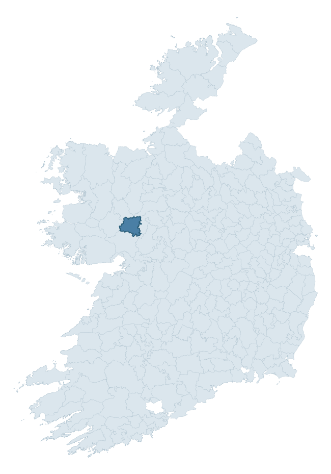
Where this barony sits in the Republic of Ireland
Geology and preservation
Bedrock geology shapes the landscape long before any settlement begins — controlling soil drainage, agricultural potential, the survival of upstanding monuments, and the preservation of buried archaeology. The figures below come from the Geological Survey Ireland 1:100,000 bedrock map.
The bedrock underlying Dunmore is predominantly limestone (48% of the barony by area), laid down during the Carboniferous period (100% by area, around 359 to 299 million years ago). Limestone is the most heritage-rich bedrock in Ireland. It supports fertile, well-drained soils that favoured dense Early Medieval settlement and Norman manorial agriculture, and it weathers into karst features — sinkholes, caves, swallow holes, and souterrains — that frequently carry archaeology. Where peat overlies limestone, organic preservation can be exceptional. A substantial secondary geology of black calcarenites and shales (25%) adds further variety to the underlying landscape. With 7 distinct rock types mapped, the barony sits in the top third of ROI baronies for geological diversity (71st percentile) — typically a sign of complex tectonic history or coastal mosaics of differing rock units.
Rock type composition
Largest mapped unit: Ballymore Limestone Formation (25% of the barony)
Placename evidence
Logainm records 41 heritage-diagnostic placenames for Dunmore, drawn from townland and civil-parish names across the barony. The dominant stratum is pre-Christian and Early Medieval defensive — ráth-, lios-, dún-, and caiseal-prefixed names that mark Iron Age and early historic settlement. The leading diagnostic roots are cill- (13 — church), lios- (11 — ringfort or enclosure), and dún- (4 — hilltop fort or promontory fort). This is above the ROI average of 30.7 heritage placenames per barony. The presence of multiple heritage strata side by side indicates layered occupation of the landscape across successive prehistoric and historic periods. Logainm records 263 placenames for Dunmore (predominantly townland names). Of these, 41 (16%) carry one of the diagnostic Gaelic roots tracked above; the remainder draw on more generic landscape vocabulary that does not encode a heritage period.
Pre-Christian / Early Medieval Defensive
| Root | Count | Meaning |
|---|---|---|
| lios- | 11 | ringfort or enclosure |
| dún- | 4 | hilltop or promontory fort |
| ráth- | 3 | earthen ringfort |
Early Christian Ecclesiastical
| Root | Count | Meaning |
|---|---|---|
| cill- | 13 | church (early) |
| tobar- | 2 | holy well |
| gráinseach- | 2 | monastic farm / grange |
| cillín- | 1 | unconsecrated burial ground |
Burial, Ritual, and Norse-Contact
| Root | Count | Meaning |
|---|---|---|
| feart- | 2 | grave mound |
| tuaim- | 1 | burial mound |
| carn- | 1 | cairn |
| leacht- | 1 | grave monument |
| gall- | 1 | foreigner — Norse settlement marker |
Other baronies in Galway
About this profile
Click any section below to expand.
What is a barony?
A barony is a historic administrative unit in Ireland, broadly equivalent to an English hundred. The 280 baronies used here are from the OSi 2019 National Statutory Boundaries (generalised 20m), covering the 26 counties of the Republic of Ireland. Baronies derive from the Norman period, were formalised in the 17th century, and have not been redrawn for statistical purposes. They vary enormously in area, from compact urban baronies in Dublin to vast upland baronies in Connacht, and should not be compared by raw site count without accounting for area differences.
What counts as a site?
This profile combines three distinct heritage registers, each with its own definition of what constitutes a recordable site:
- Archaeological sites (NMS). The National Monuments Service Sites and Monuments Record (SMR) catalogues every known archaeological monument or site of archaeological interest in the Republic, from prehistoric burial mounds and ringforts to medieval churches and post-medieval defensive works. Inclusion does not require legal protection — only that the site has been identified, surveyed, and assessed as having archaeological value. A separate subset of these sites lies within a recorded protection zone, which gives them statutory protection under the National Monuments Acts.
- Listed buildings (NIAH). The National Inventory of Architectural Heritage records buildings of architectural, historical, archaeological, artistic, cultural, scientific, social, or technical interest. Each surveyed structure is appraised on a five-tier scale: International, National, Regional, Local, and Record-Only. The NIAH appraisal is informational rather than strictly statutory, but it underpins local-authority Record of Protected Structures (RPS) listings.
- Heritage placenames (Logainm). Logainm is the authoritative database of Irish placenames maintained by the Placenames Branch. This profile applies a heritage-diagnostic classifier to the Irish-language form of each townland name, flagging roots that signal defensive sites (ráth-, lios-, dún-, caiseal-, cathair-), ecclesiastical foundations (cill-, teampall-, domhnach-, mainistir-), prehistoric burial-ritual features (tuaim-, carn-, leaba-), or Norse-contact settlement (gall-). Townlands without one of these diagnostic roots are not flagged here — they may still carry historical significance, but that significance is not encoded in the name itself.
Editorial principles
The narrative sections of this profile follow several explicit principles:
- Evidential. Every claim about this barony’s heritage character is anchored in the underlying register data. Where a site count, a placename count, or a percentile rank is cited, it is computed from the source datasets at export time, not estimated.
- Comparative. Counts and metrics are reported alongside their percentile rank against the other 279 ROI baronies. A barony with 50 ringforts in absolute terms could be unusually high or unusually low depending on its size and regional context; percentile ranking removes that ambiguity.
- Transparent on limits. Where a register has known coverage gaps, survey biases, or data-quality issues that affect this barony’s figures, the profile flags them rather than presenting the numbers as definitive.
- No interpretation beyond what the data supports. The narrative does not speculate about historical events, social dynamics, or cultural meaning beyond what the recorded heritage and placename evidence directly attests.
Data caveats and limits
- NMS Sites and Monuments Record is the product of survey campaigns conducted at different intensities across different counties and decades. Some baronies have been surveyed more thoroughly than others, and absolute counts should be read in that light. Sites destroyed by development before survey are typically not represented; sites in heavily forested or upland terrain are sometimes under-recorded.
- NIAH coverage is broadly complete for the Republic of Ireland but the survey was conducted on a rolling county-by-county basis, and the most recent appraisal date varies. Buildings demolished or substantially altered after their original survey may still appear in the register; conversely, recent buildings of merit may not yet have been appraised.
- Logainm classification applies a deliberately conservative pattern-matching approach to the Irish-language townland forms. The classifier prioritises true positives over recall: a townland may carry a heritage signal that the classifier doesn’t recognise, particularly where the diagnostic root has been heavily anglicised or where the townland name draws on a less common term. The 60,000+ townland records and ~9,800 classified placenames give a substantial signal at barony scale, but individual townland names should be checked against Logainm directly for definitive interpretation.
- Period attribution. The chronological distribution reflects only those NMS sites that carry a recognised period attribution in the source data. Sites listed as “Unknown” period are excluded from the dated subset.
- Boundary changes. Some baronies have undergone minor boundary adjustments since their 19th-century definition; the OSi 2019 generalised boundaries used here are the current statutory definition and may differ slightly from historical maps in border areas.
- Bedrock geology is mapped at 1:100,000 scale, which means local variation within a barony — small pockets of different rock type, mineral veins, alluvium overlying bedrock — is generalised. The dominant-system and rocktype figures are area-weighted, so a barony reading “70% Carboniferous limestone” may still contain small but archaeologically important pockets of older or younger rock. Around 3% of GSI polygons do not match the lexicon and contribute no rocktype or system attribution.
Data sources
- National Monuments Service — Sites and Monuments Record (SMR) https://data.gov.ie/dataset/national-monuments-service-archaeological-survey-of-ireland
- National Inventory of Architectural Heritage (NIAH) https://data.gov.ie/dataset/national-inventory-of-architectural-heritage-niah-national-dataset
- Logainm — Placenames Database of Ireland https://www.logainm.ie/
- Ordnance Survey Ireland — National Statutory Barony Boundaries 2019 https://data-osi.opendata.arcgis.com/
- EURODEM — European Digital Elevation Model https://www.mapsforeurope.org/datasets/euro-dem
- ESA WorldCover https://esa-worldcover.org/en
- Geological Survey Ireland — 1:100,000 Bedrock Geology https://www.gsi.ie/en-ie/data-and-maps/Pages/Bedrock.aspx
Explore more: Search any of the 280 ROI baronies, browse by historical province, or read the methodology and data sources for the full Republic of Ireland Heritage Tool.