
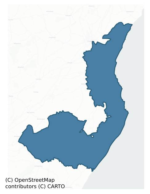
Ballaghkeen North is a barony of County Wexford, in the historical province of Leinster (Irish: An Bealach Caoin Thuaidh), covering 185 km² of land. The barony records 166 NMS archaeological sites and 126 NIAH listed buildings, placing it at around the 8th percentile among 280 ROI baronies for sites per km². This means it is in the bottom tenth of all baronies for sites per km². Dated archaeological evidence runs from the Early Bronze Age through to the Post Medieval, spanning 6 of 9 archaeological periods, placing the barony in the 16th percentile among 280 ROI baronies for chronological depth. This means it is in the bottom fifth of all baronies for chronological depth. The largest dated subset of recorded sites dates to the Iron Age. Logainm flags 40 placenames in the barony as carrying a recognised heritage root; the largest share — around 88% — are names associated with early Christian church and monastic foundations.
Heritage at a glance
Percentile rankings throughout this profile compare each barony only against the other 279 Republic of Ireland baronies.
The recorded heritage of Ballaghkeen North
The National Monuments Service Sites and Monuments Record (SMR) is the statutory inventory of archaeological sites for the Republic of Ireland, maintained by the Department of Tourism, Culture, Arts, Gaeltacht, Sport and Media. Sites recorded here include earthworks, ringforts, megalithic tombs, ecclesiastical remains, and post-medieval features; not every record is legally protected, but each is registered as a monument of archaeological interest.
The National Monuments Service records 166 archaeological sites in Ballaghkeen North, putting it at the 8th percentile among 280 ROI baronies for sites per km². This means it is in the bottom tenth of all baronies for sites per km². A sparse recorded total of this kind in Ireland often reflects survey priority rather than genuine absence of past activity. Protection coverage is near-universal — 151 sites (91%) fall within a recorded monument protection zone, indicating an extensively surveyed landscape. The record is dominated by defensive sites — ringforts, enclosures, hillforts, and stone forts (77 sites, 46% of the total), with ecclesiastical sites forming a substantial secondary presence (39 sites, 23%). Ringfort – rath is the most prevalent type, making up 16% of the barony's recorded sites (27 records), broadly in line with the ROI average of 20% across all baronies where this type occurs. Ringfort – rath is an earthen ringfort enclosed by a bank and external ditch — the most common Early Medieval farmstead, broadly dated 500–1000 AD. Other significant types include Enclosure (21) and Church (13). Enclosure is a banked or ditched feature of uncertain type, used as a catch-all where the original function cannot be determined from surface evidence; Church is a building used for public Christian worship, of any date from c. 500 AD onwards. Across the barony's 185 km², this gives a recorded density of 0.90 sites per km².
Most common monument types
Hover or tap a monument type to see its definition.
| Type | Count |
|---|---|
| Ringfort – rath an earthen ringfort enclosed by a bank and external ditch — the most common Early Medieval farmstead, broadly dated 500–1000 AD | 27 |
| Enclosure a banked or ditched feature of uncertain type, used as a catch-all where the original function cannot be determined from surface evidence | 21 |
| Church a building used for public Christian worship, of any date from c. 500 AD onwards | 13 |
| Moated site | 13 |
| Graveyard a burial area associated with a church, in use from the medieval period onwards | 13 |
| Ritual site – holy well a well or spring traditionally associated with a saint, often credited with healing properties; many trace earlier ritual origins but devotion is documented from the medieval period onwards | 11 |
| Ringfort – unclassified a circular Early Medieval settlement enclosure where surviving evidence does not allow distinction between earthen and stone forms | 10 |
| Standing stone a deliberately set upright stone, used variously as a Bronze/Iron Age burial marker, route marker or commemorative monument | 6 |
Chronological distribution
The dated archaeological record for Ballaghkeen North spans from the Early Bronze Age through to the Post Medieval, with activity attested across 6 of 9 archaeological periods. This is the 16th percentile across ROI baronies — a relatively narrow chronological band, with much of Irish prehistory not represented in the dated record. Every period from earliest to latest is represented in the record — an unbroken sequence of dated activity across the full chronological span. Activity concentrates most heavily in the Iron Age (57 sites, 46% of dated material), with the Early Medieval forming a secondary peak (32 sites, 26%). A further 41 recorded sites (25% of the overall NMS register for the barony) carry no period attribution — appearing as 'Unknown' in the bar chart below. This typically reflects either records that pre-date the standardised period vocabulary or sites awaiting specialist dating review, rather than a genuine absence of chronological evidence.
Sample of recorded monuments
Show 25 sample monuments (of 166 total)
A representative sample of 25 recorded monuments drawn from the barony’s 166 total NMS entries. Sites within a recorded monument protection zone and rarer site types are prioritised so the list shows a meaningful cross-section rather than only the most common type. Each entry shows the official Sites and Monuments Record reference number and the description published by the National Monuments Service.
Cairn – unclassified
Marked as a cairn on the 1839 and 1940 eds of the OS 6-inch map, and situated on the broad summit of Tara Hill, which John O'Donovan, writing c. 1840, considered to be the Teamhair Brogha Nia of early Ireland…
Marked as a cairn on the 1839 and 1940 eds of the OS 6-inch map, and situated on the broad summit of Tara Hill, which John O'Donovan, writing c. 1840, considered to be the Teamhair Brogha Nia of early Ireland (O'Flanagan 1933, vol. 1, 6). The cairn (dims. c. 17m N-S; c. 16m; max. H 1.5m at E) is largely covered with grass and furze, but there is a trig. station at the centre and a a quarry diam. 4m; D 0.5m) towards the SE edge.
The above description is derived from the published 'Archaeological Inventory of County Wexford' (Dublin: Stationery Office, 1996). In certain instances the entries have been revised and updated in the light of recent research.
Compiled by: Michael Moore
Date of upload/revision: 15 March 2012
Sweathouse
Located at the bottom of the SE-facing slope of Tara Hill. It is described as a 'Tumulus' but not depicted on the 1940 ed. of the OS 6-inch map. This is a stone-lined passage (L 1.9m) roofed with three lintels with an…
Located at the bottom of the SE-facing slope of Tara Hill. It is described as a 'Tumulus' but not depicted on the 1940 ed. of the OS 6-inch map. This is a stone-lined passage (L 1.9m) roofed with three lintels with an entrance (Wth of base 0.6m; Wth of top 0.75m; H 0.65m) facing ESE. It is within an overgrown earthen mound (dims c. 2.4m N-S; c. 2.1m E-W; H c. 1.9m) which is stone-faced, except at S and it backs onto a drystone wall that curves around the N side of the mound, but this side is inaccessible. The holy well (WX007-030—) is c. 16m to the N and the remains of a nineteenth century house is c. 5m to the NE.
The above description is derived from the published 'Archaeological Inventory of County Wexford' (Dublin: Stationery Office, 1996). In certain instances the entries have been revised and updated in the light of recent research.
See the attached view of the entrance
Compiled by: Michael Moore
Date of upload/revision: 15 March 2012
Amended: 24/06/2019
Cross – High cross
Situated on the outer edge of a wooded shelf overlooking the W-E Owenavorragh Stream, which is c. 70m to the N, and c. 1km from the sea-shore. A stone patio with benches is laid out around it, and paths lead through the…
Situated on the outer edge of a wooded shelf overlooking the W-E Owenavorragh Stream, which is c. 70m to the N, and c. 1km from the sea-shore. A stone patio with benches is laid out around it, and paths lead through the wood to it from a carpark to the E. This is a shale Latin cross (H 2.25m; T 0.15m) with one broken arm (Wth 1.03m). There is an incised cross in a circle (diam. 0.46m) at the intersection of the arms on both faces. (deVal 1970, 25; Ranson 1948, 102-03; Harbison 1992, vol. 1, 23)
The above description is derived from the published 'Archaeological Inventory of County Wexford' (Dublin: Stationery Office, 1996). In certain instances the entries have been revised and updated in the light of recent research.
Michael Moore
Date of upload/revision: 13 April, 2012.
Cross – Wayside cross
Situated on the highest point of the sand-dunes in the vicinity, with the sea-shore c. 150m to the E. A plain Latin cross (H 1.2m; Wth 0.72m; T 0.12-0.16m), probably 17th century in date, is now set up over a grave in…
Situated on the highest point of the sand-dunes in the vicinity, with the sea-shore c. 150m to the E. A plain Latin cross (H 1.2m; Wth 0.72m; T 0.12-0.16m), probably 17th century in date, is now set up over a grave in St Mary's graveyard. It has a slightly expanded base but no decoration. The site of Ardamine church (WX012-009003-) is c. 120m to the N, and the motte and bailey (WX012-010—-) is c. 15m to the S.
Compiled by: Michael Moore
Date of upload: 13 April, 2012
Water mill – horizontal-wheeled
Located in the bed of a NW-SE stream where it is visible as timbers prodtruding from the NE bank c. 1.3m below the ground surface. A large oak base-beam (L 2.65m; H 0.4m) is probably from the NE side of the mill pool…
Located in the bed of a NW-SE stream where it is visible as timbers prodtruding from the NE bank c. 1.3m below the ground surface. A large oak base-beam (L 2.65m; H 0.4m) is probably from the NE side of the mill pool but a plank (L 2m; Wth 0.42m plus; T 0.1m) from the wall obove it collapsed into the stream in antiquity with a weight of riverbank clay on top of it. The base-beam on the NW side (L 0.8m; dims 0.23m x 0.15m) partially survives in situ. Part of a mill-wheel arm (L 0.77m) had been found at the location in the 1970s and is kept at a nearby house.
Compiled by: Michael Moore
Date of upload: 21 May, 2012
Religious house – Monks of the Order of Tiron
Located on a gentle E-facing slope with a slight fold just to the S and the seashere is c. 50m to the NE. Monks of the Order of Tiron founded St Mary's Priory at Glascarrig, which in 1193 was made a dependency by the…
Located on a gentle E-facing slope with a slight fold just to the S and the seashere is c. 50m to the NE. Monks of the Order of Tiron founded St Mary's Priory at Glascarrig, which in 1193 was made a dependency by the Cauntetons or Condons of the daughter-house of St Dogmells' in Pembrokeshire (Gwynn and Hadcock 1970, 142-3, although the date may be later (Hore 1900-11, vol. 6, 142-3). It held many properties and benefices in Wexford and Carlow. It was suppressed in 1543. In 1560 the site was leased to Walter Pepard of Kilkea, Co. Kildare, at which time the remains included a cell, a church, a hall, two rooms, a chantry and a small yard (Grattan Flood 1905, 168-9). In 1605 the site was granted to the Earl of Thomond but by mid-century it was owned by Sir Walsingham Cooke (ibid. 170).
One wall (L 12.7m; T 0.8m; max. surviving H 3.3m) with no distinguishing features remains. Archaeological testing (99E0170) just S of this uncovered a pit (dims. 1.4m x 1.1m) containing four sherds of 12th/13th century pottery (Ó Drisceoil 2000), but further work (08E0033) failed to produce any material (Ó Drisceoil 2011). Lady's Well or Tobermurry, a rectangular well (dims. 2.5m x 3m) with concrete surrounds, lies c. 150m to SW.
The above description is derived from the published 'Archaeological Inventory of County Wexford' (Dublin: Stationery Office, 1996). In certain instances the entries have been revised and updated in the light of recent research.
Compiled by: Michael Moore
Da…
Castle – tower house
Located just off the crest of the E-facing slope of a low ridge with a N-S stream c. 540m to the E and a W-E stream c. 280m the S. The coast is c. 2.3km to the E. The Peppard family are associated with Ireland from the…
Located just off the crest of the E-facing slope of a low ridge with a N-S stream c. 540m to the E and a W-E stream c. 280m the S. The coast is c. 2.3km to the E. The Peppard family are associated with Ireland from the 13th century but there are no historical references to them in Wexford before the 16th century. In 1550 Walter Peppard of Kilkea, Co. Kildare, was granted a lease of the precinct of the suppressed monastery of Glascarrig (WX017-017001-) (Hore 1900-11, vol. 6, 147), which is c. 4.5km to the NE. He may have acquired or built the castle at Peppardstown then, but neither the Peppards nor their castle are recorded in the Civil Survey (1654-6) (Simington (1953, 41-3). Parts of the present 18th century house, which has a five-bay, two storey, W-facing front, are thought to incorporate an older building, probably a tower house, the only indication being the thickness of some walls (c. 1.5m) in the return at the back (E) side. (Jeffrey 1979, 192)
The above description is derived from the published 'Archaeological Inventory of County Wexford' (Dublin: Stationery Office, 1996). In certain instances the entries have been revised and updated in the light of recent research.
Compiled by: Michael Moore
Date of upload/revision: 15 June, 2012
Castle – unclassified
Described as the site of Morris Castle on the 1839 and 1924 eds of the OS 6-inch map, and situated on a fairly steep SE-facing slope with a small W-E stream immediately to the S. This is thought to be the castle of the…
Described as the site of Morris Castle on the 1839 and 1924 eds of the OS 6-inch map, and situated on a fairly steep SE-facing slope with a small W-E stream immediately to the S. This is thought to be the castle of the O'Morchoe or Murphy, but there is no documented history associated with it. According to the Civil Survey (1654-6) Castle Morcho was one of the many townlands in Kilmuckridge parish where Lord Mount Norris owned land in 1641, but there is no mention of the castle (Simington 1953, 43). One wall of this castle remained until 1936 when it was quarried away (Jeffrey 1979, 183–4). There are no visible remains at ground level.
The above description is derived from the published 'Archaeological Inventory of County Wexford' (Dublin: Stationery Office, 1996). In certain instances the entries have been revised and updated in the light of recent research.
Compiled by: Michael Moore
Date of upload/revision: 18 June, 2012
Castle – motte
Situated at the E end of a low W-E spur with a slight N-S stream flowing around the base of the spur NE-E-S c. 100m distant. The sea-shore is c. 2 km to the SE. Strongbow granted Kilmuckridge to de Borrard for two…
Situated at the E end of a low W-E spur with a slight N-S stream flowing around the base of the spur NE-E-S c. 100m distant. The sea-shore is c. 2 km to the SE. Strongbow granted Kilmuckridge to de Borrard for two kinghts fees and the motte can be attributed to de Borrard (Colfer 1987, 96, No. 20). This is a grass and scrub-covered, flat-topped earthen mound (diam. of top 22.5m; diam. of base c. 36m; H 6.5–7m) with an earthen bank (Wth c. 2m; int. H 1m) at summit SW-N-E and a complete flat-bottomed fosse (D below exterior 1.8m at W to 3m at N) at the base. There is an outer bank (Wth c. 2m; ext. H c. 1m) SW-NW. A rectangular bailey may have existed in the flat overgrown platform (dims. c. 30m N–S; c. 30m E–W) immediately to the N.
The above description is derived from the published 'Archaeological Inventory of County Wexford' (Dublin: Stationery Office, 1996). In certain instances the entries have been revised and updated in the light of recent research.
Compiled by: Michael Moore
Date of upload/revision: 18 June, 2012
Well
It is called Toberindiry in the Civil Survey (1654-6) where it is a significant point on the boundary between Meelinagh and Castle Ellis parishes (Simington 1953, 51). It is described as Toberdeera on the 1839 ed. of…
It is called Toberindiry in the Civil Survey (1654-6) where it is a significant point on the boundary between Meelinagh and Castle Ellis parishes (Simington 1953, 51). It is described as Toberdeera on the 1839 ed. of the OS 6-inch map, and is located just off the SW-facing slope of a col between hills c. 900m to the NNW and c. 370m to the SSE and at a point where three townlands meet. This is a natural spring that is the source of two streams, one of which is the River Sow and runs off to the SW and the other runs off the to the S but joins the Sow below Ballaghkeen village, c. 1.5km distant. There is no evidence that it was ever venerated.
Compiled by: Michael Moore
Date of upload: 17 July, 2012
Flat cemetery
Situated on a NE-facing slope with a small NW-SE stream c. 100m to the NE, and the sea-shore is c. 700m to the SE. A Vase urn with a cremation (Grattan-Esmonde 1903, 69-70), a bowl food vessel with a crouched inhumation…
Situated on a NE-facing slope with a small NW-SE stream c. 100m to the NE, and the sea-shore is c. 700m to the SE. A Vase urn with a cremation (Grattan-Esmonde 1903, 69-70), a bowl food vessel with a crouched inhumation in a cist that may have been discovered in 1888 and a bowl food vessel, possibly with cremation in a cist, (Ó Ríordáin 1936, 187-90) were discovered in close proximity to each other. (Waddell 1990. 157)
The above description is derived from the published 'Archaeological Inventory of County Wexford' (Dublin: Stationery Office, 1996). In certain instances the entries have been revised and updated in the light of recent research.
Compiled by: Michael Moore
Date of upload/revision: 18 July 2012
Graveslab
Within the graveyard (WX019-003002-). A graveslab commemorating Mary, the wife of Walsingham Cooke and her grandson Walsingham Parsons, dated 1641, is within the church (WX019-003001-) at the E end. It may cover a…
Within the graveyard (WX019-003002-). A graveslab commemorating Mary, the wife of Walsingham Cooke and her grandson Walsingham Parsons, dated 1641, is within the church (WX019-003001-) at the E end. It may cover a vault. (Hore 1911, vol. 6, 570–1).
Compiled by: Michael Moore
Date of upload: 21 May, 2012
Cremation pit
Excavated (E3486) during 2005 by E. Moore as part of Site 21 at Coolnaveagh, which was one of the excavations undertaken in advance of the construction of the N11 Arklow-Gorey link-road. Situated on a slight E-facing…
Excavated (E3486) during 2005 by E. Moore as part of Site 21 at Coolnaveagh, which was one of the excavations undertaken in advance of the construction of the N11 Arklow-Gorey link-road. Situated on a slight E-facing slope with the canalised N-S Banoge River c. 100m to the E. A single pit (dims 1.23m NW-SE; 1.06m NE-SW; D 0.25m) contained three fills, two of which had cremated bone. The ring-ditch (WX012-033001-) is c. 60m to the WSW, fulacht fia (WX012-034003-) is c. 100m t the ESE and fulacht fia (WX012-034008-) is c. 55m to the NE with the rath (WX012-003—-) c. 75m to the NE. (Moore 2008, 5)
Compiled by: Michael Moore
Date of upload: 8 May, 2012
Bawn
By 1621 Sir Francis Annesley had built a house (WX022-019—-) with a court or bawn (Loeber and Stouthamer-Loeber 1987, 189-90). Only one D-shaped mural tower (int. dims. 2.9m N-S; 1.4m E-W) from the E side of the bawn…
By 1621 Sir Francis Annesley had built a house (WX022-019—-) with a court or bawn (Loeber and Stouthamer-Loeber 1987, 189-90). Only one D-shaped mural tower (int. dims. 2.9m N-S; 1.4m E-W) from the E side of the bawn survives (H 3.5) with walls of roughly coursed stone (T 1m). The tower is now open-backed, but it may have had an entrance (Wth 1.5m) at W to the ground floor that has five lights (Wth 7-11cm; H 32cm). There was at least one light on the first floor.
Compiled by: Michael Moore
Date of upload: 18 June, 2012
Habitation site
Situated on a slight N-facing slope. Archaeological testing (18E0334) in the area between the church of Ballynure (WX022-013001-) and its associated holy well (WX022-014—-) located c. 130m to the E identified numerous…
Situated on a slight N-facing slope. Archaeological testing (18E0334) in the area between the church of Ballynure (WX022-013001-) and its associated holy well (WX022-014—-) located c. 130m to the E identified numerous features in Upton townland including a pit (dims 2.3m plus; D 0.25m plus) which produced medieval pottery. There was also an E-W fosse (Wth c. 3m; L 10m plus), gullies, a charcoal-flecked clay floor (dims c. 20m plus E-W; c. 3m N-S), pits and a second clay floor (dim. 12m plus). Medieval pottery was recovered from the first pit, but other wares together with worked flints were found throughout the tested area, suggesting that the habitation floors are prehistoric, perhaps Bronze Age, in date. (McLoughlin 2018)
Compiled by: Michael Moore
Date of upload: 10 August, 2018
Bullaun stone
A bullaun stone in a green stone (dims 0.85m plus x 0.8m; T 0.1-0.22m) with a single basin (diam. 0.42-00.45m; D 0.1-0.13m) in its upper surface that is now built into the wall of the graveyard at Boleyvogue Roman…
A bullaun stone in a green stone (dims 0.85m plus x 0.8m; T 0.1-0.22m) with a single basin (diam. 0.42-00.45m; D 0.1-0.13m) in its upper surface that is now built into the wall of the graveyard at Boleyvogue Roman Catholic Church (WX021-050—-) was originally from the this graveyard. It had been moved out of the graveyard onto the wet ground around it before being moved to Boleyvogue in 1934 (IFC: Schools’ MSS Volume 0890, 102).
Compiled by: Michael Moore
Date of upload: 17 April, 2023
IFC Schools’ MSS: Irish Folklore Commission Schools Manuscripts. Department of Folklore, University College, Dublin
Enclosure – large enclosure
Situated on a S-facing slope. The cropmark of a large oval enclosure (dims c. 105m N-S; c. 75m E-W) is visible only on iMAPs (2022). It is defined by what are probably two closely spaced ditch features NW-E-SE which…
Situated on a S-facing slope. The cropmark of a large oval enclosure (dims c. 105m N-S; c. 75m E-W) is visible only on iMAPs (2022). It is defined by what are probably two closely spaced ditch features NW-E-SE which combine into a wider E-W ditch (L c. 40m) at S and then turns NW. The perimeter is truncated by a N-S field bank at W (L c. 65m) and an E-W field bank runs through the E part. It was first reported by Jean Charles Caillére.
See the attached enhanced view from iMAPs (2022)
Compiled by: Michael Moore
Date of upload: 6 June 2023
House – 17th century
Lands were granted to Sir Edward Fisher in 1612 as the manor of Chichester, but it was called Fisherstown in 1618. By this time a brick castle with two square flankers, a court or bawn with square flankers and a walled…
Lands were granted to Sir Edward Fisher in 1612 as the manor of Chichester, but it was called Fisherstown in 1618. By this time a brick castle with two square flankers, a court or bawn with square flankers and a walled garden '110 feet by 72 feet' had been built. It passed by marriage to Sir Edward Chichester but it was described as 'a decayed Manor House' at Prospect in the Civil Survey (1654-56) (Simington 1953, 35-6). The estate amounted to 1650 acres that was probably the entirety of Kiltennell parish. The location of the manor house at Prospect is generally know, but there are no visible features at ground level. (Loeber and Stouthamer-Loeber 1987, 196–7)
The above description is derived from the published 'Archaeological Inventory of County Wexford' (Dublin: Stationery Office, 1996). In certain instances the entries have been revised and updated in the light of recent research.
Compiled by: Michael Moore
Date of upload/revision: 16 March, 2012
Castle – motte and bailey
Situated on the sand-dunes overlooking the sea-shore c. 100m to the E. This is a flat-topped, scrub-covered earthen mound (dims. of top 7m N-S: 5m E-W; H 6m; diam. of base c. 25m). The remains of a bailey (dims 10m N-S;…
Situated on the sand-dunes overlooking the sea-shore c. 100m to the E. This is a flat-topped, scrub-covered earthen mound (dims. of top 7m N-S: 5m E-W; H 6m; diam. of base c. 25m). The remains of a bailey (dims 10m N-S; 10m E-W) are SE of the motte but it may have extended further W. The stone cross (WX012-009002-) is c. 15m to the N, and the church site (WX012-009003-) is c. 140m to the N. It is traditionally thought to be Ard Ladhran, the burial place of a mythical warrior (Ua Dubhghaill 1925, 90).
The above description is derived from the published 'Archaeological Inventory of County Wexford' (Dublin: Stationery Office, 1996). In certain instances the entries have been revised and updated in the light of recent research.
Compiled by: Michael Moore
Date of upload/revision: 17 July 2007
Promontory fort – coastal
Situated on the coast at Polshone Head with the sea immedately adjacent NW-SE and a ravine on the S side. This grass-covered area is defended by two fosses. The inner enclosure is subcircular or D-shaped (dims. 32m E-W;…
Situated on the coast at Polshone Head with the sea immedately adjacent NW-SE and a ravine on the S side. This grass-covered area is defended by two fosses. The inner enclosure is subcircular or D-shaped (dims. 32m E-W; 29m N-S) defined by scarps (H 1.6-2m) at N and S and destroyed by sea erosion at E, but a curving bank (Wth 5m; int. H 0.4m; ext. H 1.2m) with an external fosse (Wth of top 8m; Wth of base 3m; D 1.2m) and counterscarp bank (Wth c. 4m; ext. H 0.3m) survive S-NW. The outer enclosure to the W is triangular (dims. 28m E-W; 23m N-S at E) with the apex at W whre it is defined by a fosse across the promontory (Wth of top 6m; D 2m). The inner enclosure may have been a rath imposed on earlier defences.
The above description is derived from the published 'Archaeological Inventory of County Wexford' (Dublin: Stationery Office, 1996). In certain instances the entries have been revised and updated in the light of recent research.
Compiled by: Michael Moore
Date of upload/revision: 13 April, 2012
Castle – motte and bailey
Returning from Wales in 1167 Diarmuid Mac Murchada landed at Glascarrig, which may have served as a port for Ferns (Colfer 2002, 11). After the Anglo-Norman invasion of 1170 Glascarrig was granted to Raymond le Gros and…
Returning from Wales in 1167 Diarmuid Mac Murchada landed at Glascarrig, which may have served as a port for Ferns (Colfer 2002, 11). After the Anglo-Norman invasion of 1170 Glascarrig was granted to Raymond le Gros and by the end of the century it had passed to his nephew William de Caunteton, who may have constructed the motte. The Cauntetons continued to hold the manor of Glascarrig until it was destroyed by MacMurchada in 1311, after which it may have been abandoned. Forty eight burgages are recorded in 1311 (Griffith 1952, 160), indicating a substantial settlement. (Breen 2007, 67-8).
The motte is located on a slight promontory (H c. 10m) overlooking the seashore immediately to the N and E. It is a flat-topped, grass-covered earthen mound (diam. of top 13m; diam. of base 36m; H 5.8-6m) defined by a flat-bottomed fosse (Wth of top 6–8m; D 0.5m at N to 1.7m at S). A possible bailey (dims. 37m E-W; 24-27m N-S) is a grass-covered area to the S defined by the sea at E, a gorge (D 4m) at S and an earthen bank (Wth 4-05m; ext. H 1m; L 27m) at W. The E side of the motte's fosse is being eroded by the sea.
The above description is derived from the published 'Archaeological Inventory of County Wexford' (Dublin: Stationery Office, 1996). In certain instances the entries have been revised and updated in the light of recent research.
Compiled by: Michael Moore
Date of upload/revision: 21 May, 2012
Mound
Marked as a hachured feature with an adjacent quarry only on the 1924 ed. of the OS 6-inch map. It is located on a broad, low-lying ridge. This is a grass-covered earthen mound with some trees. It has a flat top (diam.…
Marked as a hachured feature with an adjacent quarry only on the 1924 ed. of the OS 6-inch map. It is located on a broad, low-lying ridge. This is a grass-covered earthen mound with some trees. It has a flat top (diam. of base 12m; diam. of top 7m; H 2.5m), but no visible ditch or other features.
The above description is derived from the published 'Archaeological Inventory of County Wexford' (Dublin: Stationery Office, 1996). In certain instances the entries have been revised and updated in the light of recent research.
Compiled by: Michael Moore
Date of upload/revision: 15 June, 2012
House – 17th century
The manor of Annesley was granted to Sir Francis Annesley in 1618, and by 1621 he had built what is described as a small castle, which probably consisted of a two-and-a-half- storey house and court (Loeber and…
The manor of Annesley was granted to Sir Francis Annesley in 1618, and by 1621 he had built what is described as a small castle, which probably consisted of a two-and-a-half- storey house and court (Loeber and Stouthamer-Loeber 1987, 189–90). According to the Civil Survey (1654-6) Lord Annesley had an estate of 1270 acres in Kilmuckridge parish in 1641 (Simington 1953, 43), but the castle is not mentioned. The land, which probably consisted of the holding of the Ó Morchoes of Morris Castle (WX022-017—-), was in the townlands of Castle Moro, Litter, Ballinure, Ballyheige, Tanekrie, Kilmockrish, Ballingarran, Ballinloe, Ballyhoboge, and the unknown Taininvony and Taneddan, which together may be Dundrum townland.
The house is located at the head of a small N-S valley, with the source of a small stream just to the W. The site of a the house is now occupied by a farm complex. Only one D-shaped mural tower (int. dims 2.9m N-S; 1.4m E-W) from the E side of the bawn survives (H 3.5) with walls of roughly coursed stone (T 1m). The tower is now open-backed, but it may have had an entrance (Wth 1.5m) at W to the ground floor that has five lights (Wth 7-11cm; H 32cm). There was at least one light on the first floor.
The above description is derived from the published 'Archaeological Inventory of County Wexford' (Dublin: Stationery Office, 1996). In certain instances the entries have been revised and updated in the light of recent research.
Compiled by: Michael Moore
Da…
Mound
Located on a rise in a low-lying landscape with the sea-shore c. 1 km to the SE. A mound (diam. of base 13m; diam. of top 3m; H 3m) at the SW corner of moated site (WX022-011001-) is known locally as the…
Located on a rise in a low-lying landscape with the sea-shore c. 1 km to the SE. A mound (diam. of base 13m; diam. of top 3m; H 3m) at the SW corner of moated site (WX022-011001-) is known locally as the 'moat'.
Compiled by: Michael Moore
Date of upload: 18 June, 2012
Ringfort – rath
Located at the W edge of a slight N-S ridge. This is a slightly raised and overgrown circular area (diam. 32m) defined by the remains of an earthen bank (Wth 2.5m; int. H 0.5m; ext. H 1–1.5m) E–S-W and a scarp…
Located at the W edge of a slight N-S ridge. This is a slightly raised and overgrown circular area (diam. 32m) defined by the remains of an earthen bank (Wth 2.5m; int. H 0.5m; ext. H 1–1.5m) E–S-W and a scarp elsewhere. There is no visible fosse or entrance. Archaeological monitoring (02E0261) outside a 20m buffer zone SW-N-E failed to produce any related material (O'Donnell, 2004).
The above description is derived from the published 'Archaeological Inventory of County Wexford' (Dublin: Stationery Office, 1996). In certain instances the entries have been revised and updated in the light of recent research.
Compiled by: Michael Moore
Date of upload/revision: 18 June, 2012
Listed buildings
The National Inventory of Architectural Heritage (NIAH) is a state survey appraising buildings of architectural, historical, archaeological, artistic, cultural, scientific, social, or technical interest. Each surveyed structure receives a rating from International (the highest, for buildings of European importance) through National, Regional, Local, and Record-Only.
The NIAH records 126 listed buildings in Ballaghkeen North (60th percentile across ROI baronies). The highest-graded structures include 2 of National significance. The Republic holds 937 National-graded buildings in total, so this barony accounts for around 0% of the national total. Construction dates concentrate most heavily in the Victorian (1830-1900) period. The most-recorded building type is farm house (32 examples, 25% of the listed stock).
Terrain and environment
Mean elevation across the barony is 51m — the 16th percentile among 280 ROI baronies for elevation. This means it is in the bottom fifth of all baronies for elevation. This is a relatively low-lying landscape by ROI standards. Elevation matters for heritage because higher-altitude baronies typically favour defensive monuments — ringforts and hilltop forts placed on prominent ground — while lowland baronies are more likely to carry the dense settlement and church networks of intensive agricultural landscapes. A maximum elevation of 249m gives the barony meaningful vertical relief. Mean slope is 3.2° — the 42nd percentile among 280 ROI baronies for slope. This means it is in the lower half of all baronies for slope. Slope is a key control on both land use and archaeological preservation: steep ground resists ploughing and tends to preserve earthworks intact, while gentle slopes favour intensive cultivation that damages or destroys surface archaeology over time. The Topographic Wetness Index averages 10.9, the 52nd percentile among 280 ROI baronies for wetness. This means it is in the upper half of all baronies for wetness. Drainage matters for heritage because poorly-drained ground preserves organic archaeology (wooden trackways, leather, textiles, and on rare occasions human remains) far better than free-draining soil; well-drained ground favours arable use but destroys organic material rapidly. The land-cover mosaic combines improved grassland (70%), arable farmland (14%), and woodland (13%), giving a mixed agricultural and semi-natural landscape.
Terrain measurements
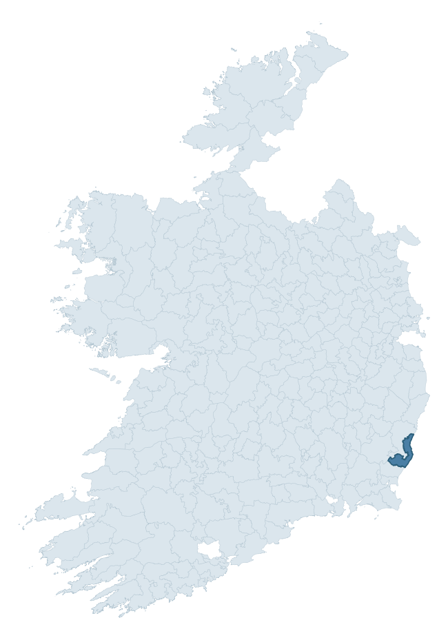
Where this barony sits in the Republic of Ireland
Geology and preservation
Bedrock geology shapes the landscape long before any settlement begins — controlling soil drainage, agricultural potential, the survival of upstanding monuments, and the preservation of buried archaeology. The figures below come from the Geological Survey Ireland 1:100,000 bedrock map.
The bedrock underlying Ballaghkeen North is predominantly slate (48% of the barony by area), laid down during the Ordovician period (71% by area, around 485 to 444 million years ago). Slate weathers to thin upland soils but provides high-value building and roofing stone, which often shows in surviving 19th-century rural and ecclesiastical architecture. A substantial secondary geology of sandstone (25%) and rhyolite (10%) adds further variety to the underlying landscape. The single largest mapped unit is the Ballyhoge Formation (46% of the barony's bedrock). With 8 distinct rock types mapped, the barony sits in the top third of ROI baronies for geological diversity (79th percentile) — typically a sign of complex tectonic history or coastal mosaics of differing rock units.
Rock type composition
Largest mapped unit: Ballyhoge Formation (46% of the barony)
Placename evidence
Logainm records 40 heritage-diagnostic placenames for Ballaghkeen North, drawn from townland and civil-parish names across the barony. The dominant stratum is Early Christian ecclesiastical — cill-, teampall-, and domhnach-prefixed names that record the dense network of early church foundations established between the fifth and tenth centuries. The leading diagnostic roots are cill- (26 — church), cillín- (3 — killeen), and ráth- (2 — earthen ringfort). This is above the ROI average of 30.7 heritage placenames per barony. The presence of multiple heritage strata side by side indicates layered occupation of the landscape across successive prehistoric and historic periods. Logainm records 234 placenames for Ballaghkeen North (predominantly townland names). Of these, 40 (17%) carry one of the diagnostic Gaelic roots tracked above; the remainder draw on more generic landscape vocabulary that does not encode a heritage period.
Pre-Christian / Early Medieval Defensive
| Root | Count | Meaning |
|---|---|---|
| ráth- | 2 | earthen ringfort |
| dún- | 1 | hilltop or promontory fort |
Early Christian Ecclesiastical
| Root | Count | Meaning |
|---|---|---|
| cill- | 26 | church (early) |
| cillín- | 3 | unconsecrated burial ground |
| domhnach- | 2 | pre-Patrician or earliest Patrician church |
| tobar- | 2 | holy well |
| teampall- | 1 | church (later medieval) |
| gráinseach- | 1 | monastic farm / grange |
Burial, Ritual, and Norse-Contact
| Root | Count | Meaning |
|---|---|---|
| tuaim- | 2 | burial mound |
Other baronies in Wexford
About this profile
Click any section below to expand.
What is a barony?
A barony is a historic administrative unit in Ireland, broadly equivalent to an English hundred. The 280 baronies used here are from the OSi 2019 National Statutory Boundaries (generalised 20m), covering the 26 counties of the Republic of Ireland. Baronies derive from the Norman period, were formalised in the 17th century, and have not been redrawn for statistical purposes. They vary enormously in area, from compact urban baronies in Dublin to vast upland baronies in Connacht, and should not be compared by raw site count without accounting for area differences.
What counts as a site?
This profile combines three distinct heritage registers, each with its own definition of what constitutes a recordable site:
- Archaeological sites (NMS). The National Monuments Service Sites and Monuments Record (SMR) catalogues every known archaeological monument or site of archaeological interest in the Republic, from prehistoric burial mounds and ringforts to medieval churches and post-medieval defensive works. Inclusion does not require legal protection — only that the site has been identified, surveyed, and assessed as having archaeological value. A separate subset of these sites lies within a recorded protection zone, which gives them statutory protection under the National Monuments Acts.
- Listed buildings (NIAH). The National Inventory of Architectural Heritage records buildings of architectural, historical, archaeological, artistic, cultural, scientific, social, or technical interest. Each surveyed structure is appraised on a five-tier scale: International, National, Regional, Local, and Record-Only. The NIAH appraisal is informational rather than strictly statutory, but it underpins local-authority Record of Protected Structures (RPS) listings.
- Heritage placenames (Logainm). Logainm is the authoritative database of Irish placenames maintained by the Placenames Branch. This profile applies a heritage-diagnostic classifier to the Irish-language form of each townland name, flagging roots that signal defensive sites (ráth-, lios-, dún-, caiseal-, cathair-), ecclesiastical foundations (cill-, teampall-, domhnach-, mainistir-), prehistoric burial-ritual features (tuaim-, carn-, leaba-), or Norse-contact settlement (gall-). Townlands without one of these diagnostic roots are not flagged here — they may still carry historical significance, but that significance is not encoded in the name itself.
Editorial principles
The narrative sections of this profile follow several explicit principles:
- Evidential. Every claim about this barony’s heritage character is anchored in the underlying register data. Where a site count, a placename count, or a percentile rank is cited, it is computed from the source datasets at export time, not estimated.
- Comparative. Counts and metrics are reported alongside their percentile rank against the other 279 ROI baronies. A barony with 50 ringforts in absolute terms could be unusually high or unusually low depending on its size and regional context; percentile ranking removes that ambiguity.
- Transparent on limits. Where a register has known coverage gaps, survey biases, or data-quality issues that affect this barony’s figures, the profile flags them rather than presenting the numbers as definitive.
- No interpretation beyond what the data supports. The narrative does not speculate about historical events, social dynamics, or cultural meaning beyond what the recorded heritage and placename evidence directly attests.
Data caveats and limits
- NMS Sites and Monuments Record is the product of survey campaigns conducted at different intensities across different counties and decades. Some baronies have been surveyed more thoroughly than others, and absolute counts should be read in that light. Sites destroyed by development before survey are typically not represented; sites in heavily forested or upland terrain are sometimes under-recorded.
- NIAH coverage is broadly complete for the Republic of Ireland but the survey was conducted on a rolling county-by-county basis, and the most recent appraisal date varies. Buildings demolished or substantially altered after their original survey may still appear in the register; conversely, recent buildings of merit may not yet have been appraised.
- Logainm classification applies a deliberately conservative pattern-matching approach to the Irish-language townland forms. The classifier prioritises true positives over recall: a townland may carry a heritage signal that the classifier doesn’t recognise, particularly where the diagnostic root has been heavily anglicised or where the townland name draws on a less common term. The 60,000+ townland records and ~9,800 classified placenames give a substantial signal at barony scale, but individual townland names should be checked against Logainm directly for definitive interpretation.
- Period attribution. The chronological distribution reflects only those NMS sites that carry a recognised period attribution in the source data. Sites listed as “Unknown” period are excluded from the dated subset.
- Boundary changes. Some baronies have undergone minor boundary adjustments since their 19th-century definition; the OSi 2019 generalised boundaries used here are the current statutory definition and may differ slightly from historical maps in border areas.
- Bedrock geology is mapped at 1:100,000 scale, which means local variation within a barony — small pockets of different rock type, mineral veins, alluvium overlying bedrock — is generalised. The dominant-system and rocktype figures are area-weighted, so a barony reading “70% Carboniferous limestone” may still contain small but archaeologically important pockets of older or younger rock. Around 3% of GSI polygons do not match the lexicon and contribute no rocktype or system attribution.
Data sources
- National Monuments Service — Sites and Monuments Record (SMR) https://data.gov.ie/dataset/national-monuments-service-archaeological-survey-of-ireland
- National Inventory of Architectural Heritage (NIAH) https://data.gov.ie/dataset/national-inventory-of-architectural-heritage-niah-national-dataset
- Logainm — Placenames Database of Ireland https://www.logainm.ie/
- Ordnance Survey Ireland — National Statutory Barony Boundaries 2019 https://data-osi.opendata.arcgis.com/
- EURODEM — European Digital Elevation Model https://www.mapsforeurope.org/datasets/euro-dem
- ESA WorldCover https://esa-worldcover.org/en
- Geological Survey Ireland — 1:100,000 Bedrock Geology https://www.gsi.ie/en-ie/data-and-maps/Pages/Bedrock.aspx
Explore more: Search any of the 280 ROI baronies, browse by historical province, or read the methodology and data sources for the full Republic of Ireland Heritage Tool.