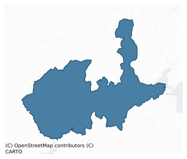
Shelmaliere West is a barony of County Wexford, in the historical province of Leinster (Irish: Síol Maoluír Thiar), covering 206 km² of land. The barony records 328 NMS archaeological sites and 172 NIAH listed buildings, placing it at around the 38th percentile among 280 ROI baronies for sites per km². This means it is in the lower half of all baronies for sites per km². Dated archaeological evidence runs from the Neolithic through to the Modern, spanning 8 of 9 archaeological periods, placing the barony in the 87th percentile among 280 ROI baronies for chronological depth. This means it is in the top fifth of all baronies for chronological depth. The largest dated subset of recorded sites dates to the Iron Age. Logainm flags 20 placenames in the barony as carrying a recognised heritage root; the largest share — around 45% — are names associated with early Christian church and monastic foundations.
Heritage at a glance
Percentile rankings throughout this profile compare each barony only against the other 279 Republic of Ireland baronies.
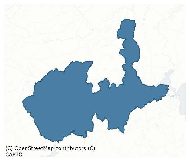
The recorded heritage of Shelmaliere West
The National Monuments Service Sites and Monuments Record (SMR) is the statutory inventory of archaeological sites for the Republic of Ireland, maintained by the Department of Tourism, Culture, Arts, Gaeltacht, Sport and Media. Sites recorded here include earthworks, ringforts, megalithic tombs, ecclesiastical remains, and post-medieval features; not every record is legally protected, but each is registered as a monument of archaeological interest.
The National Monuments Service records 328 archaeological sites in Shelmaliere West, putting it at the 38th percentile among 280 ROI baronies for sites per km². This means it is in the lower half of all baronies for sites per km². Protection coverage is near-universal — 306 sites (93%) fall within a recorded monument protection zone, indicating an extensively surveyed landscape. The record is dominated by defensive sites — ringforts, enclosures, hillforts, and stone forts (138 sites, 42% of the total), with ecclesiastical sites forming a substantial secondary presence (72 sites, 22%). Ringfort – rath is the most prevalent type, making up 17% of the barony's recorded sites (55 records), broadly in line with the ROI average of 20% across all baronies where this type occurs. Ringfort – rath is an earthen ringfort enclosed by a bank and external ditch — the most common Early Medieval farmstead, broadly dated 500–1000 AD. Other significant types include Moated site (31) and Church (26). Church is a building used for public Christian worship, of any date from c. 500 AD onwards. Across the barony's 206 km², this gives a recorded density of 1.60 sites per km².
Most common monument types
Hover or tap a monument type to see its definition.
| Type | Count |
|---|---|
| Ringfort – rath an earthen ringfort enclosed by a bank and external ditch — the most common Early Medieval farmstead, broadly dated 500–1000 AD | 55 |
| Moated site | 31 |
| Church a building used for public Christian worship, of any date from c. 500 AD onwards | 26 |
| Ritual site – holy well a well or spring traditionally associated with a saint, often credited with healing properties; many trace earlier ritual origins but devotion is documented from the medieval period onwards | 20 |
| Graveyard a burial area associated with a church, in use from the medieval period onwards | 20 |
| Enclosure a banked or ditched feature of uncertain type, used as a catch-all where the original function cannot be determined from surface evidence | 20 |
| Burnt mound a heap of fire-cracked stone, ash and charcoal, with no surviving trough, dated Bronze Age to early medieval | 20 |
| Castle – tower house a fortified residential tower of four or five storeys, mostly built by lords in the 15th and 16th centuries and often within a defended bawn | 11 |
Chronological distribution
The dated archaeological record for Shelmaliere West spans from the Neolithic through to the Modern, with activity attested across 8 of 9 archaeological periods. This is the 87th percentile across ROI baronies for chronological depth — an above-average span. Every period from earliest to latest is represented in the record — an unbroken sequence of dated activity across the full chronological span. Activity concentrates most heavily in the Iron Age (100 sites, 40% of dated material), with the Medieval forming a secondary peak (53 sites, 21%). A further 81 recorded sites (25% of the overall NMS register for the barony) carry no period attribution — appearing as 'Unknown' in the bar chart below. This typically reflects either records that pre-date the standardised period vocabulary or sites awaiting specialist dating review, rather than a genuine absence of chronological evidence.
Sample of recorded monuments
Show 25 sample monuments (of 328 total)
A representative sample of 25 recorded monuments drawn from the barony’s 328 total NMS entries. Sites within a recorded monument protection zone and rarer site types are prioritised so the list shows a meaningful cross-section rather than only the most common type. Each entry shows the official Sites and Monuments Record reference number and the description published by the National Monuments Service.
Promontory fort – inland
Marked as a circular embanked enclosure (ext. diam. c. 55m) on the 1839 ed. of the OS 6-inch map and situated on the W side of a broad N-S spur between the River Slaney on the E and a N-S tributary stream on the W that…
Marked as a circular embanked enclosure (ext. diam. c. 55m) on the 1839 ed. of the OS 6-inch map and situated on the W side of a broad N-S spur between the River Slaney on the E and a N-S tributary stream on the W that is called Redenegh in the Civil Survey (1654-6) (Simington 1953, 101, 104). This is a natural triangular or oval promontory (dims 49m E-W; 38m N-S) in mixed woodland with cliffs (H c. 10m) at N and S, and the remains of a fosse visible as a vegetation change (Wth 4-8m) in pasture at the E (landward) side.
The following above is derived from the published 'Archaeological Inventory of County Wexford' (Dublin: Stationery Office, 1996). In certain instances the entries have been revised and updated in the light of recent research.
Compiled by: Michael Moore
Date of upload/revision: 31 August, 2012
Megalithic tomb – portal tomb
Situated on a slight E-facing slope. The tomb has collapsed, but it is oriented N-S and faces N. At present it consists of a large roofstone resting on two portal stones, two sidestones and a split backstone but these…
Situated on a slight E-facing slope. The tomb has collapsed, but it is oriented N-S and faces N. At present it consists of a large roofstone resting on two portal stones, two sidestones and a split backstone but these stones have fallen inwards. (Grattan Flood 1912, 15-17: Ó Nuallain 1983, 103)
The above description is derived from the published 'Archaeological Inventory of County Wexford' (Dublin: Stationery Office, 1996). In certain instances the entries have been revised and updated in the light of recent research.
Compiled by: Michael Moore
Date of upload/revision: 16 October, 2012
House – 16th/17th century
References date certainly from the early 17th century when a castle, possibly not this structure, was owned by David Synnott (Jeffrey 1979, 99 100). According to the Civil Survey (1654-6) David Synnott owned 180 acres…
References date certainly from the early 17th century when a castle, possibly not this structure, was owned by David Synnott (Jeffrey 1979, 99 100). According to the Civil Survey (1654-6) David Synnott owned 180 acres at Brownscastle and the castle is described as ‘a small pile of stone out of repair’ (Simington 1953, 82). It is situated on rock outcrop overlooking the E-W Corrock river c. 60m to the N, and a defile through the S escarpment of the steep-sided valley is immediately to the W. The defile now has a roadway leading to Taghmon, c. 2 km to the S, but an old roadway winds up the escarpment from the NE and passes immediately W of the monument before turning SE.
This is a small two storey house (int. dims. 8.1m N-S; 2.75m E-W) constructed of shale with no dressed stone. There is a doorway (Wth 1.25m) towards the N end of the W wall, and there was probably a similar doorway at the same point on the E wall. There are two small slit windows in the long walls and one in the end walls at the ground floor. The joists for the ceiling are set directly into the long walls, but there are arches (D c. 1m) attached to the inner faces of the N and S walls, spanning the building. The first floor has two narrow lights on the E wall and one each on the other walls, that on the W wall with a horizontal slit beneath it. There is no evidence of a fireplace or of a stairs. There W doorway opens into a D-shaped enclosure (int. dims 5.9m N-S; 5.7m E-W) defined by masonry walls (T 0.3-0….
House – 17th/18th century
Located on a gentle S-facing slope. The castle of Ballinloskran (WX036-054—-) may have been located where Tottenhamgreen House was built c. 1700. Ballinloskran is thought to be Tottenhamgreen now as it is described in…
Located on a gentle S-facing slope. The castle of Ballinloskran (WX036-054—-) may have been located where Tottenhamgreen House was built c. 1700. Ballinloskran is thought to be Tottenhamgreen now as it is described in the Civil Survey (1654-6) as being between the Corrock River (river of Pill), Shanowle and Horetown (Simington 1953, 87). A grant of 478 acres in Ballyloskan was made in 1667 to a Charles Collins, who subsequently sold it to John Tottenham of Ballyduff, Co. Waterford (Jeffrey 1979, 95). The house at Tottenhamgreen was a five-bay one story over a high basement and attic house with a large pediment on the entrance front. A wing was added to one end in the same style c. 1712. The house was demolished c. 1950. (Bence-Jones 1978, 274-5)
Compiled by: Michael Moore
Date of upload: 8 November, 2012
Castle – ringwork
Situated on a promontory (H c. 10m) overlooking the W-E River Slaney at a narrow point (Wth c. 100m NE-SW) before it enters the inner harbour of Wexford. When the Anglo-Normans captured Wexford town in 1169, Dermot Mac…
Situated on a promontory (H c. 10m) overlooking the W-E River Slaney at a narrow point (Wth c. 100m NE-SW) before it enters the inner harbour of Wexford. When the Anglo-Normans captured Wexford town in 1169, Dermot Mac Murrough granted it and the surrounding area to Maurice FitzGerald and Robert FitzStephen, and the latter fortified the steep rock at ‘Karrech’ with an earthen bank and a palisade. On the death of Dermot in May 1171, the Irish rebelled, captured Wexford town and besieged FitzStephen behind the ‘earthen rampart’ at Carraig. FitzStephen surrendered to trickery and was handed over the King Henry II at Waterford later in the year. The enclosure is described as the ‘castrum de Karrich’ in 1231-34, testifying to its continued use as a strongpoint. The castle is mentioned again in 1307 when it appears to have been in good repair, but by 1323-4 it is described in an inquisition as vacant and consisting of an unroofed hall and chapel (Orpen 1906, 33). The castle is described as burnt in 1420 but it would still be the centre of the manor (Hore 1900-11, vol. 5, 130). References to the manor and castle continue into the late 16th century, and in time it came to be known as Shanacourt (Old Castle) (Orpen 1906 29-34). An antiquarian footnote by J. Hooker in Holinshed’s ‘Chronicles of Ireland’ (1587, vol. 2, 11) and quoted by Orpen describes the castle as ‘first made of rods and turfs, according to the manner in those daies, but since builded with stone, and was the strong…
Pit-burial
Situated towards the N end of a N-S ridge with the narrow part of the W-E River Slaney (Wth c. 100m NE-SW) c. 170m to the NE. The rim of a collared urn and a small sample of cremated bone, probably representing an older…
Situated towards the N end of a N-S ridge with the narrow part of the W-E River Slaney (Wth c. 100m NE-SW) c. 170m to the NE. The rim of a collared urn and a small sample of cremated bone, probably representing an older adolescent, were recovered from what was probably a pit-burial in 1984 (Sikora 2011).
The above description is derived from the published 'Archaeological Inventory of County Wexford' (Dublin: Stationery Office, 1996). In certain instances the entries have been revised and updated in the light of recent research.
Compiled by: Michael Moore
Date of upload/revision: 14 December, 2012
Castle – motte and bailey
The manor of Rosegarland was held in 1247 by Maurice de London (or de Londres) by the service of two knights from the Vallence purpartry and he also held Duncormick (WX046-035001-) (Brooks 1950, 103). Rosegarland…
The manor of Rosegarland was held in 1247 by Maurice de London (or de Londres) by the service of two knights from the Vallence purpartry and he also held Duncormick (WX046-035001-) (Brooks 1950, 103). Rosegarland occupied the territory between the Owenduff and Corock rivers, and embraced the parishes of Inch, Clongeen and Ballylannan (Orpen 1934, 60), but by 1308 it had passed through marriage to George le Poer. In 1385 it passed by marriage to Simon de Neville and the Nevilles held it in a feodary of 1425 (Brooks 1950, 104-05). The Nevilles may have moved the centre of the manor to Rosegarland (WX040-042—-).
The motte at Newcastle, which was also known as Rath Gorey moat according to John O’Donovan writing c. 1840 (O’Flanagan 1933, vol. 2, 355), may have been the first caput of the Rosegarland manor. It is located on a slight rise at the E edge of a fairly level landscape with a small valley opening off the NE. It is an overgrown and flat topped earthen mound (diam. of top 10m; diam. of base 30m; H 7.3m) defined by a flat-bottomed fosse (Wth of base 2.3m; ext. D 1.8-2.5m). The motte is at the W side of a crescent-shaped bailey (dims. 40m N-S; 29m E-W) defined by an earthen bank (at E: Wth 6.5m; int. H 1m; ext. H 2.7m) and an external, flat-bottomed fosse (at E: Wth of top 7m; Wth of base c. 1.5m; ext. D 1.8m). The bailey may have been adapted from a pre-existing rath, as evidenced by the upstanding bank on its perimeter and its local name of Rathgorey (Murphy, c. 1994…
Cross – High cross
Situated in the NW corner of the graveyard (WX041-008012-) associated with the present St. Munna’s Church of Ireland church that is probably on the site of the medieval parish church (WX041-007016-). The head of a…
Situated in the NW corner of the graveyard (WX041-008012-) associated with the present St. Munna’s Church of Ireland church that is probably on the site of the medieval parish church (WX041-007016-). The head of a granite cross is set on one of its side-arms in what was probably its original granite base, but it is unlikely that this is the original position of the cross. The head (H 1.41m; Wth 1.36m; T 0.22m) has a solid ring with a moulding around the edges of both faces and it is decorated with five simple bosses on each side. The base (dims of bottom 1.36m x 1.2m; dims of top 1.07m x 0.92m; H 1.18m) has a ringless cross in false relief with one central boss and expanded terminals on the arms on one of the larger panels but is otherwise plain. (Harbison 1992, vol. 1, 168)
The above description is derived from the published 'Archaeological Inventory of County Wexford' (Dublin: Stationery Office, 1996). In certain instances the entries have been revised and updated in the light of recent research.
Compiled by: Michael Moore
Date of upload/revision: 20 March, 2013
Religious house – Augustinian, of Arrouaise nuns
Depicted as a small rectangular structure (dims c. 10m x c. 5m) described as a 'Nunnery (in ruins)' on the 1839 Ed. of the OS 6-inch map and located on a gentle S-facing slope adjacent to the site of St Munna's church…
Depicted as a small rectangular structure (dims c. 10m x c. 5m) described as a 'Nunnery (in ruins)' on the 1839 Ed. of the OS 6-inch map and located on a gentle S-facing slope adjacent to the site of St Munna's church (WX041-008003-). This may be the site of a pre-Anglo-Norman nunnery which became Arroasian in 12th century but was derelict by c. 1330 (Gwynn and Hadcock 1970, 324). It might also be the site of St Bridget's church mentioned in 1543, 1558 and 1615, which was part of the possessions of the Knights Hospitallers of Kilcolgan (Hore 1906, vol. 5, 420 21; vol. 4, 287 ). According to a Visitation by Thomas Ram, the Protestant bishop of Ferns, in 1615 there was no priest, and the condition of the church building was not recorded (ibid. vol. 6, 271). The outline of a rectangular structure (dims. 18.5m E-W; 12.8m N-S) defined by low earthen banks (Wth 4m; H 0.2-0.8m) with a possible entrance (Wth 2m) at S was visible in 1988. A possible trackway (Wth c. 5m) running E-W (L c. 70m), defined by low earthen banks, was c. 30m to the S. The site of the Nunnery Well (WX041-008005-) is c. 75m to the SE. Archaeological testing (97E0450) in the vicinity failed to recovery any related material (Hurley 1998).
The above description is derived from the published 'Archaeological Inventory of County Wexford' (Dublin: Stationery Office, 1996). In certain instances the entries have been revised and updated in the light of recent research.
Compiled by: Michael Moore
Date of uplo…
House – fortified house
References date from 1640 when a ‘castle in good repair’ and 180 acres at Hilltown were owned by William Esmond, together with 190 acres in Ballymitty and 180 acres in Ballyknock (Simington 1953, 89). It is situated on…
References date from 1640 when a ‘castle in good repair’ and 180 acres at Hilltown were owned by William Esmond, together with 190 acres in Ballymitty and 180 acres in Ballyknock (Simington 1953, 89). It is situated on a level landscape. This is a rectangular house of three storeys with an entrance tower offset to the E and S. The rectangular entrance tower (ext. dims. 7.8m NW-SE; 4.35m NE-SW) with granite quoins survives complete to the simple crenellations, although the doorway cannot be identified and there are no internal stairs or other features surviving. The stairs tower has four floors with many inserted features, but only one slit window and two double- light windows are original.
The house (ext. dims 12.8m NE-SW; 7.45m NW-SE) has three floors surviving to the top of the second storey windows, with a machicolation at the SW angle. Four rectangular windows, two with double-lights, and all with square hood-mouldings are the only original windows at the first floor. One window on the ground floor and three double-light and two single-light windows at the second floor are also original. There is a fireplace at the first floor in the NE wall and projecting chimney flues are visible at the second floor on the SW and NW walls. The upper floors of the house were supported on corbels in the NW and SE walls, and there is no evidence of vaulting, garderobes, stairs, or of the original doorways between the house and the services tower. Both the house and the tower had gable…
Enclosure – large enclosure
Situated on a broad N-S ridge. The cropmark of a large enclosure (dims. c. 145m NE-SW; c. 115m NW-SE) with straight sides at SE and SW is faintly visible on aerial photographs (MM (8) 10-15; (57) 0, 1). This is either a…
Situated on a broad N-S ridge. The cropmark of a large enclosure (dims. c. 145m NE-SW; c. 115m NW-SE) with straight sides at SE and SW is faintly visible on aerial photographs (MM (8) 10-15; (57) 0, 1). This is either a field boundary or the perimeter of what might have been an enclosed wood.
The above description is derived from the published 'Archaeological Inventory of County Wexford' (Dublin: Stationery Office, 1996). In certain instances the entries have been revised and updated in the light of recent research.
Compiled by: Michael Moore
Date of upload/revision: 20 March, 2013
Cairn – unclassified
Situated on one of the summits of the ENE-WSW Forth Mountain ridge. A cairn known as ‘Clorane’ was described by John O'Donovan writing c. 1840 as being ‘one hundred paces in circumference and six feet in perpendicular…
Situated on one of the summits of the ENE-WSW Forth Mountain ridge. A cairn known as ‘Clorane’ was described by John O'Donovan writing c. 1840 as being ‘one hundred paces in circumference and six feet in perpendicular height (diam. c. 30m; H c. 1.8m)’ (O'Flanagan, 1933, vol. 2, 76). Some stones are visible at the site although there is no cairn.
The above description is derived from the published 'Archaeological Inventory of County Wexford' (Dublin: Stationery Office, 1996). In certain instances the entries have been revised and updated in the light of recent research.
Compiled by: Michael Moore
Date of upload/revision: 27 May, 2013
Ritual site – holy/saint's stone
Located towards the top of a N-facing slope that forms the S side of the steep-sided valley of the E-W Corrock River. It is on the S side of a forest road in a coniferous forest. The name of the townland to the E,…
Located towards the top of a N-facing slope that forms the S side of the steep-sided valley of the E-W Corrock River. It is on the S side of a forest road in a coniferous forest. The name of the townland to the E, Cloghulatagh, is derived from Cloch Chodlata – the stone of sleep – and undoubtedly refers to the saint's stone (Pers. com. Conchubhar Ó Crualaoich). Traditionally, St. Munna (Ó Riain 2011, 505-07) of Taghmon (WX041-008—-), which is c. 2km to the S, slept here overnight, having watered his horse at the well (WX036-036001-), c. 100m to the E. The bed is an area bedrock (L c. 3m; Wth c. 1m) sloping down to the W.
Compiled by: Michael Moore
Date of upload: 8 November, 2012
Amended: 16 July, 2014
House – medieval
Partially excavated (00E0471) as part of the N25 Wexford to New Ross re-alignment. The moated site (WX036-079001-) has the remains of a wooden house in the interior. This is defined by wide, shallow foundation trenches…
Partially excavated (00E0471) as part of the N25 Wexford to New Ross re-alignment. The moated site (WX036-079001-) has the remains of a wooden house in the interior. This is defined by wide, shallow foundation trenches providing uncertain dimensions for the house. A hearth in the N extremity of the structure produced a C14 date of cal AD 1400-1450, but a second more central hearth is more likely to be primary and there was evidence of the destruction of the building which produced a C14 date of cal AD 1318-1450 (Eogan and Kelly 2016, 222). (Tierney and Johnston 2006, 10, 11; Tierney 2009, 193-4)
Compiled by: Michael Moore
Date of revised upload: 1 February, 2017
Metalworking site
Situated on the SW bank of a NW-SE stream. Archaeological testing (06E0187) in advance of development identified an area with metalworking waste and burnt clay located c. 15m S of the possible mill-race (WX040-027005-).…
Situated on the SW bank of a NW-SE stream. Archaeological testing (06E0187) in advance of development identified an area with metalworking waste and burnt clay located c. 15m S of the possible mill-race (WX040-027005-). (McLoughlin 2006b, 8)
Compiled by: Michael Moore
Date of upload: 19 February, 2013
Road – hollow-way
Situated on level ground at the SW base of Forth Mountain. Immediately to the W of the castle (WX041-027—-) is a N-S sunken track or fosse (L 150m; Wth 4-8m). There was exposed stonework visible at the N end of this…
Situated on level ground at the SW base of Forth Mountain. Immediately to the W of the castle (WX041-027—-) is a N-S sunken track or fosse (L 150m; Wth 4-8m). There was exposed stonework visible at the N end of this feature in 1988. All the features have eroded further through ploughing.
Compiled by: Michael Moore
Date of upload: 19 March, 2013
Habitation site
Situated on a slight S-facing slope. This was identified by R. Tobin in monitoring work (08E0627 ext.) associated with the development of a Community Centre outside the W edge of Taghmon. An area (dims. c. 20m x c. 20m)…
Situated on a slight S-facing slope. This was identified by R. Tobin in monitoring work (08E0627 ext.) associated with the development of a Community Centre outside the W edge of Taghmon. An area (dims. c. 20m x c. 20m) contains extensive archaeological deposits suggesting habitation, including post-holes, a possible ditch and a possible kiln. The excavated kiln (WX041-067001-) is c. 40m to the NW, (Tobin 2009).
Compiled by: Michael Moore
Date of upload: 20 March, 2013
Water mill – unclassified
Located in the valley of a small NW-SE stream. Archaeological testing (06E0187) in advance of development c. 120m S and SW of the parish church of Clongeen (WX040-027001-) identified a number of features including a…
Located in the valley of a small NW-SE stream. Archaeological testing (06E0187) in advance of development c. 120m S and SW of the parish church of Clongeen (WX040-027001-) identified a number of features including a linear ditch (Wth 4m; D 0.9-1.3m) running E-W (L c. 125m) (McLoughlin 2006b, addendum), which was further tested (06E0834) leading to the conclusion that it may have been a mill-race, although no structure of a mill was recorded (Purcell 2009).
Compiled by: Michael Moore
Date of upload: 19 February, 2013
Ritual site – holy tree/bush
St. Eusebius’ Well (WX037-023—-) is situated towards the head of a small W-E valley and in an recess cut into an embankment on the N side of an E-W laneway. John O’Donovan writing c. 1840 recorded that the well…
St. Eusebius’ Well (WX037-023—-) is situated towards the head of a small W-E valley and in an recess cut into an embankment on the N side of an E-W laneway. John O’Donovan writing c. 1840 recorded that the well provided a cure for sore eyes and headaches, and that there was a rag tree adjacent. (O’Flanagan 1933, vol. 1, 359). A holly tree growing from the embankment of the recess at N has some hanging baskets and plastic bags, some of which appear to contain samples of medical bandages. The church (WX037-024001-) is c. 100m to the S.
Compiled by: Michael Moore
Date of upload: 7 June, 2013
Midden
Excavated completely (00E0471) as part of the investigation of the moated site (WX036-079001-) on the N25 Wexford to New Ross re-alignment. Outside the NE moat and about 10m NE of the kiln (WX036-079002-) was an area…
Excavated completely (00E0471) as part of the investigation of the moated site (WX036-079001-) on the N25 Wexford to New Ross re-alignment. Outside the NE moat and about 10m NE of the kiln (WX036-079002-) was an area where occupation deposits containing ceramic waste and one small semi-circle of stake-holes representing a temporary shelter were recovered. This area is likely to have been the location of a midden and dung-heap, and it produced a calibrated C14 date of cal. AD 1297-1431 (Eogan and Kelly 2016, 218). The area was bordered at N by an E-W ditch that contained ceramic waste and turned N at its E end. (Tierney 2002; 2009, 194-5; Tierney and Johnston 2006, 14, 15)
Compiled by: Michael Moore
Date of upload: 1 February, 2017
Settlement cluster
Situated on the floodplain of the meandering N-S Corrock River, which is c. 50m to the W at the closest point, and on land that was once part of the demesne of Coolcliffe House. A magnetic gradiometer survey (20R0129)…
Situated on the floodplain of the meandering N-S Corrock River, which is c. 50m to the W at the closest point, and on land that was once part of the demesne of Coolcliffe House. A magnetic gradiometer survey (20R0129) over an extensive area identified numerous linear features in a fairly small area (dims c. 180m N-S; c. 60-90m E-W) with features extending outside the surveyed area to the W. At least three small rectangular enclosures (max. dims c. 17m x c. 7m) could represent houses or farm buildings and there are associated small plots (dims c. 20m x c. 10-30m). (Nicholls 2020, 12 F 50-52; Figs 14, 27)
Compiled by: Michael Moore
Date of upload: 30 December 2020
Mound
Marked as a small mound only on the 1925 ed. of the OS 6-inch map and situated in the valley of a small W-E stream on a steep E-facing slope, with the stream immediately to the S. It is described as an earthen mound ’20…
Marked as a small mound only on the 1925 ed. of the OS 6-inch map and situated in the valley of a small W-E stream on a steep E-facing slope, with the stream immediately to the S. It is described as an earthen mound ’20 feet by 18 feet and about 2 feet high’ (dims. c. 6m; H c. 0.6m) known as ‘Mullaun a plaugh’ that was thought locally to be a burial place of plague victims (Sheil 1921, 116). It was removed in 1978 when no human remains were recorded (Wexford People, 09-06-1978; 16-06-1978), and it may have been a fulacht fia.
The above description is derived from the published 'Archaeological Inventory of County Wexford' (Dublin: Stationery Office, 1996). In certain instances the entries have been revised and updated in the light of recent research.
Compiled by: Michael Moore
Date of upload/revision: 28 August, 2012
Water mill – horizontal-wheeled
Located in the valley of a NW-SE stream, c. 55m upstream from Fary Bridge. A number of worked oak timbers are visible under water, protruding from the NE bank of the fast flowing stream.
The above description is…
Located in the valley of a NW-SE stream, c. 55m upstream from Fary Bridge. A number of worked oak timbers are visible under water, protruding from the NE bank of the fast flowing stream.
The above description is derived from the published 'Archaeological Inventory of County Wexford' (Dublin: Stationery Office, 1996). In certain instances the entries have been revised and updated in the light of recent research.
Compiled by: Michael Moore
Date of upload/revision: 12 October, 2012
House – 17th century
References date from the early seventeenth century when it was occupied by Thomas Roche, although owned by the Suttons (Jeffrey 1979, 110). In 1641 Robert Roche owned 180 acres at Dungeer and Mulmontry but the castle is…
References date from the early seventeenth century when it was occupied by Thomas Roche, although owned by the Suttons (Jeffrey 1979, 110). In 1641 Robert Roche owned 180 acres at Dungeer and Mulmontry but the castle is not mentioned (Simington 1953, 82). However, the castle is described in the boundary of Bantry barony (ibid. 199), and it is marked on the 1839 and 1924 eds of the OS 6 inch map where it is described in gothic lettering as ‘Castle (in Ruins)’. It is situated on a bluff on the N side of the ravine of the E-W Corrock river, with the valley of a smaller N-S stream immediately to the W.
One Z-shaped section of wall survives to three storeys (H c. 8m) that probably represents the SE angle of a house with a return to the S. The remains consists of one wall (L 6m E-W) with fragments of wall extending N from the E end (int. L 0.2m) and S from the W end (int. L 2m) at ground level. The ceiling of the ground and second floors was supported on rebates in the S wall, but granite corbels supported the ceiling of the first floor. At the ground floor there is a musket loop and window (Wth 0.85m) in the E-W wall and a musket loop in the S return. There is a fireplace in the S wall at the first floor and a cupboard in the wall at the second floor. Archaeological testing (05E1252) within c. 35m to N produced no related material, (Stafford 2008).
See the attached section from the Down Survey (1656-8) parish map (N at top) reproduced courtesy of the National Library of I…
Ringfort – rath
Located on a slight SE-facing slope. A circular enclosure (diam. c. 30m), probably defined by two fosse features, is visible on aerial photograph (CUCAP: BDR 12). It is not visible at ground level. Archaeological…
Located on a slight SE-facing slope. A circular enclosure (diam. c. 30m), probably defined by two fosse features, is visible on aerial photograph (CUCAP: BDR 12). It is not visible at ground level. Archaeological testing (19E0130) c. 100m to the E produced no related material (McLoughlin 2019; excavations.ie 2019:065).
The above description is derived from the published 'Archaeological Inventory of County Wexford' (Dublin: Stationery Office, 1996). In certain instances the entries have been revised and updated in the light of recent research.
Compiled by: Michael Moore
Date of upload: 8 November, 2012
Revised: 9 November 2020
Listed buildings
The National Inventory of Architectural Heritage (NIAH) is a state survey appraising buildings of architectural, historical, archaeological, artistic, cultural, scientific, social, or technical interest. Each surveyed structure receives a rating from International (the highest, for buildings of European importance) through National, Regional, Local, and Record-Only.
The NIAH records 172 listed buildings in Shelmaliere West, the 72nd percentile across ROI baronies for listed-building density. The highest-graded structure include 1 of National significance. The Republic holds 937 National-graded buildings in total, so this barony accounts for around 0% of the national total. Construction dates concentrate most heavily in the Victorian (1830-1900) period. The most-recorded building type is farm house (36 examples, 21% of the listed stock).
Terrain and environment
Mean elevation across the barony is 56m — the 20th percentile among 280 ROI baronies for elevation. This means it is in the bottom third of all baronies for elevation. This is a relatively low-lying landscape by ROI standards. Elevation matters for heritage because higher-altitude baronies typically favour defensive monuments — ringforts and hilltop forts placed on prominent ground — while lowland baronies are more likely to carry the dense settlement and church networks of intensive agricultural landscapes. A maximum elevation of 231m gives the barony meaningful vertical relief. Mean slope is 3.5° — the 48th percentile among 280 ROI baronies for slope. This means it is in the lower half of all baronies for slope. Slope is a key control on both land use and archaeological preservation: steep ground resists ploughing and tends to preserve earthworks intact, while gentle slopes favour intensive cultivation that damages or destroys surface archaeology over time. The Topographic Wetness Index averages 10.8, the 46th percentile among 280 ROI baronies for wetness. This means it is in the lower half of all baronies for wetness. Drainage matters for heritage because poorly-drained ground preserves organic archaeology (wooden trackways, leather, textiles, and on rare occasions human remains) far better than free-draining soil; well-drained ground favours arable use but destroys organic material rapidly. The land-cover mosaic combines improved grassland (58%), woodland (20%), and arable farmland (20%), giving a mixed agricultural and semi-natural landscape.
Terrain measurements
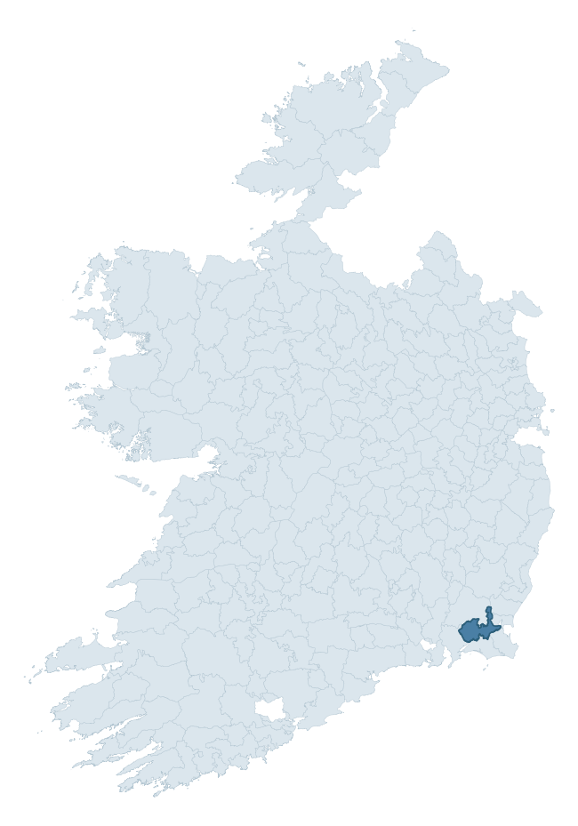
Where this barony sits in the Republic of Ireland
Geology and preservation
Bedrock geology shapes the landscape long before any settlement begins — controlling soil drainage, agricultural potential, the survival of upstanding monuments, and the preservation of buried archaeology. The figures below come from the Geological Survey Ireland 1:100,000 bedrock map.
The bedrock underlying Shelmaliere West is predominantly slate (33% of the barony by area), laid down during the Ordovician period (51% by area, around 485 to 444 million years ago). Slate weathers to thin upland soils but provides high-value building and roofing stone, which often shows in surviving 19th-century rural and ecclesiastical architecture. A substantial secondary geology of rhyolite (21%) and sandstone (16%) adds further variety to the underlying landscape. With 9 distinct rock types mapped, the barony sits in the top third of ROI baronies for geological diversity (88th percentile) — typically a sign of complex tectonic history or coastal mosaics of differing rock units.
Rock type composition
Largest mapped unit: Campile Formation (21% of the barony)
Placename evidence
Logainm records 20 heritage-diagnostic placenames for Shelmaliere West, drawn from townland and civil-parish names across the barony. The dominant stratum is Early Christian ecclesiastical — cill-, teampall-, and domhnach-prefixed names that record the dense network of early church foundations established between the fifth and tenth centuries. The leading diagnostic roots are cill- (8 — church), ráth- (5 — earthen ringfort), and tuaim- (3 — burial mound). This is below the ROI average of 30.7 heritage placenames per barony, suggesting either lighter survey coverage or a townland-naming tradition that draws more on generic landscape vocabulary. The presence of multiple heritage strata side by side indicates layered occupation of the landscape across successive prehistoric and historic periods. Logainm records 181 placenames for Shelmaliere West (predominantly townland names). Of these, 20 (11%) carry one of the diagnostic Gaelic roots tracked above; the remainder draw on more generic landscape vocabulary that does not encode a heritage period.
Pre-Christian / Early Medieval Defensive
| Root | Count | Meaning |
|---|---|---|
| ráth- | 5 | earthen ringfort |
| dún- | 2 | hilltop or promontory fort |
Early Christian Ecclesiastical
| Root | Count | Meaning |
|---|---|---|
| cill- | 8 | church (early) |
| teampall- | 1 | church (later medieval) |
Burial, Ritual, and Norse-Contact
| Root | Count | Meaning |
|---|---|---|
| tuaim- | 3 | burial mound |
| uaimh- | 1 | cave / souterrain |
Other baronies in Wexford
About this profile
Click any section below to expand.
What is a barony?
A barony is a historic administrative unit in Ireland, broadly equivalent to an English hundred. The 280 baronies used here are from the OSi 2019 National Statutory Boundaries (generalised 20m), covering the 26 counties of the Republic of Ireland. Baronies derive from the Norman period, were formalised in the 17th century, and have not been redrawn for statistical purposes. They vary enormously in area, from compact urban baronies in Dublin to vast upland baronies in Connacht, and should not be compared by raw site count without accounting for area differences.
What counts as a site?
This profile combines three distinct heritage registers, each with its own definition of what constitutes a recordable site:
- Archaeological sites (NMS). The National Monuments Service Sites and Monuments Record (SMR) catalogues every known archaeological monument or site of archaeological interest in the Republic, from prehistoric burial mounds and ringforts to medieval churches and post-medieval defensive works. Inclusion does not require legal protection — only that the site has been identified, surveyed, and assessed as having archaeological value. A separate subset of these sites lies within a recorded protection zone, which gives them statutory protection under the National Monuments Acts.
- Listed buildings (NIAH). The National Inventory of Architectural Heritage records buildings of architectural, historical, archaeological, artistic, cultural, scientific, social, or technical interest. Each surveyed structure is appraised on a five-tier scale: International, National, Regional, Local, and Record-Only. The NIAH appraisal is informational rather than strictly statutory, but it underpins local-authority Record of Protected Structures (RPS) listings.
- Heritage placenames (Logainm). Logainm is the authoritative database of Irish placenames maintained by the Placenames Branch. This profile applies a heritage-diagnostic classifier to the Irish-language form of each townland name, flagging roots that signal defensive sites (ráth-, lios-, dún-, caiseal-, cathair-), ecclesiastical foundations (cill-, teampall-, domhnach-, mainistir-), prehistoric burial-ritual features (tuaim-, carn-, leaba-), or Norse-contact settlement (gall-). Townlands without one of these diagnostic roots are not flagged here — they may still carry historical significance, but that significance is not encoded in the name itself.
Editorial principles
The narrative sections of this profile follow several explicit principles:
- Evidential. Every claim about this barony’s heritage character is anchored in the underlying register data. Where a site count, a placename count, or a percentile rank is cited, it is computed from the source datasets at export time, not estimated.
- Comparative. Counts and metrics are reported alongside their percentile rank against the other 279 ROI baronies. A barony with 50 ringforts in absolute terms could be unusually high or unusually low depending on its size and regional context; percentile ranking removes that ambiguity.
- Transparent on limits. Where a register has known coverage gaps, survey biases, or data-quality issues that affect this barony’s figures, the profile flags them rather than presenting the numbers as definitive.
- No interpretation beyond what the data supports. The narrative does not speculate about historical events, social dynamics, or cultural meaning beyond what the recorded heritage and placename evidence directly attests.
Data caveats and limits
- NMS Sites and Monuments Record is the product of survey campaigns conducted at different intensities across different counties and decades. Some baronies have been surveyed more thoroughly than others, and absolute counts should be read in that light. Sites destroyed by development before survey are typically not represented; sites in heavily forested or upland terrain are sometimes under-recorded.
- NIAH coverage is broadly complete for the Republic of Ireland but the survey was conducted on a rolling county-by-county basis, and the most recent appraisal date varies. Buildings demolished or substantially altered after their original survey may still appear in the register; conversely, recent buildings of merit may not yet have been appraised.
- Logainm classification applies a deliberately conservative pattern-matching approach to the Irish-language townland forms. The classifier prioritises true positives over recall: a townland may carry a heritage signal that the classifier doesn’t recognise, particularly where the diagnostic root has been heavily anglicised or where the townland name draws on a less common term. The 60,000+ townland records and ~9,800 classified placenames give a substantial signal at barony scale, but individual townland names should be checked against Logainm directly for definitive interpretation.
- Period attribution. The chronological distribution reflects only those NMS sites that carry a recognised period attribution in the source data. Sites listed as “Unknown” period are excluded from the dated subset.
- Boundary changes. Some baronies have undergone minor boundary adjustments since their 19th-century definition; the OSi 2019 generalised boundaries used here are the current statutory definition and may differ slightly from historical maps in border areas.
- Bedrock geology is mapped at 1:100,000 scale, which means local variation within a barony — small pockets of different rock type, mineral veins, alluvium overlying bedrock — is generalised. The dominant-system and rocktype figures are area-weighted, so a barony reading “70% Carboniferous limestone” may still contain small but archaeologically important pockets of older or younger rock. Around 3% of GSI polygons do not match the lexicon and contribute no rocktype or system attribution.
Data sources
- National Monuments Service — Sites and Monuments Record (SMR) https://data.gov.ie/dataset/national-monuments-service-archaeological-survey-of-ireland
- National Inventory of Architectural Heritage (NIAH) https://data.gov.ie/dataset/national-inventory-of-architectural-heritage-niah-national-dataset
- Logainm — Placenames Database of Ireland https://www.logainm.ie/
- Ordnance Survey Ireland — National Statutory Barony Boundaries 2019 https://data-osi.opendata.arcgis.com/
- EURODEM — European Digital Elevation Model https://www.mapsforeurope.org/datasets/euro-dem
- ESA WorldCover https://esa-worldcover.org/en
- Geological Survey Ireland — 1:100,000 Bedrock Geology https://www.gsi.ie/en-ie/data-and-maps/Pages/Bedrock.aspx
Explore more: Search any of the 280 ROI baronies, browse by historical province, or read the methodology and data sources for the full Republic of Ireland Heritage Tool.