
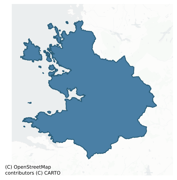
Boylagh is a barony of County Donegal, in the historical province of Ulster (Irish: Baollaigh), covering 645 km² of land. The barony records 178 NMS archaeological sites and 124 NIAH listed buildings, placing it at around the 0th percentile among 280 ROI baronies for sites per km². This means it is in the bottom tenth of all baronies for sites per km². Dated archaeological evidence runs from the Mesolithic through to the Modern, spanning 8 of 9 archaeological periods, placing the barony in the 87th percentile among 280 ROI baronies for chronological depth. This means it is in the top fifth of all baronies for chronological depth. The largest dated subset of recorded sites dates to the Early Medieval. Logainm flags 25 placenames in the barony as carrying a recognised heritage root; the largest share — around 48% — are names associated with early Christian church and monastic foundations.
Heritage at a glance
Percentile rankings throughout this profile compare each barony only against the other 279 Republic of Ireland baronies.
The recorded heritage of Boylagh
The National Monuments Service Sites and Monuments Record (SMR) is the statutory inventory of archaeological sites for the Republic of Ireland, maintained by the Department of Tourism, Culture, Arts, Gaeltacht, Sport and Media. Sites recorded here include earthworks, ringforts, megalithic tombs, ecclesiastical remains, and post-medieval features; not every record is legally protected, but each is registered as a monument of archaeological interest.
The National Monuments Service records 178 archaeological sites in Boylagh, putting it at the 0th percentile among 280 ROI baronies for sites per km². This means it is in the bottom tenth of all baronies for sites per km². A sparse recorded total of this kind in Ireland often reflects survey priority rather than genuine absence of past activity. Protection coverage is near-universal — 161 sites (90%) fall within a recorded monument protection zone, indicating an extensively surveyed landscape. The record is dominated by ecclesiastical sites — churches, graveyards, and holy wells (58 sites, 33% of the total), with defensive sites forming a substantial secondary presence (33 sites, 19%). Ritual site – holy well is the most prevalent type, making up 8% of the barony's recorded sites (15 records) — well above the ROI average of 3% across all baronies where this type occurs. Ritual site – holy well is a well or spring traditionally associated with a saint, often credited with healing properties; many trace earlier ritual origins but devotion is documented from the medieval period onwards. Other significant types include Cross-slab (14) and Ringfort – cashel (11). Cross-slab is a stone slab inscribed with a cross, used as a grave-marker or memorial, dated pre-1200 AD; Ringfort – cashel is the stone-walled equivalent of the rath, found mainly in upland or western areas, broadly dated 500–1000 AD. Across the barony's 645 km², this gives a recorded density of 0.28 sites per km².
Most common monument types
Hover or tap a monument type to see its definition.
| Type | Count |
|---|---|
| Ritual site – holy well a well or spring traditionally associated with a saint, often credited with healing properties; many trace earlier ritual origins but devotion is documented from the medieval period onwards | 15 |
| Cross-slab a stone slab inscribed with a cross, used as a grave-marker or memorial, dated pre-1200 AD | 14 |
| Ringfort – cashel the stone-walled equivalent of the rath, found mainly in upland or western areas, broadly dated 500–1000 AD | 11 |
| Church a building used for public Christian worship, of any date from c. 500 AD onwards | 10 |
| Graveyard a burial area associated with a church, in use from the medieval period onwards | 9 |
| Burial ground an area set apart for burial that is not associated with a church, in use from the medieval period onwards | 7 |
Chronological distribution
The dated archaeological record for Boylagh spans from the Mesolithic through to the Modern, with activity attested across 8 of 9 archaeological periods. This is the 87th percentile across ROI baronies for chronological depth — an above-average span. The record is near-continuous, with only the Medieval period falling inside the span without any recorded sites. Activity concentrates most heavily in the Early Medieval (65 sites, 54% of dated material), with the Iron Age forming a secondary peak (21 sites, 17%). A further 57 recorded sites (32% of the overall NMS register for the barony) carry no period attribution — appearing as 'Unknown' in the bar chart below. This typically reflects either records that pre-date the standardised period vocabulary or sites awaiting specialist dating review, rather than a genuine absence of chronological evidence.
Sample of recorded monuments
Show 25 sample monuments (of 178 total)
A representative sample of 25 recorded monuments drawn from the barony’s 178 total NMS entries. Sites within a recorded monument protection zone and rarer site types are prioritised so the list shows a meaningful cross-section rather than only the most common type. Each entry shows the official Sites and Monuments Record reference number and the description published by the National Monuments Service.
Cist
In 1937 workmen levelling a mound discovered a double cist burial here. The mound was oval 19ft E-W × 16ft 6in N-S × 3ft 6in high. It was composed of dry sandy soil held in position by a kerb of large boulders and…
In 1937 workmen levelling a mound discovered a double cist burial here. The mound was oval 19ft E-W × 16ft 6in N-S × 3ft 6in high. It was composed of dry sandy soil held in position by a kerb of large boulders and similarly sized boulders were scattered over the mound surface. A cist covered by two capstones lay 3ft below the mound surface near the W kerb i.e. approximately level with the outside ground surface. It consisted of two compartments each 32in E-W × 11in and 14in deep and was formed of thin limestone slabs. The slabs were held in place by packing stones. Each compartment contained an individual disarticulated burial, head to the W. Other skeletal material was found in the mound, including two tiny skulls probably representing the use of the site as a Cillin or burial ground for unbaptized children up to c. AD 1850. The site is located E of Lough Fad in an area of good pasture interrupted by patches of rougher ground.
(Raftery 1942, 122-6)
The above description was derived from the 'Archaeological Survey of County Donegal. A description of the field antiquities of the County from the Mesolithic Period to the 17th century.' Compiled by: Brian Lacey with Eamon Cody, Claire Cotter, Judy Cuppage, Noel Dunne, Vincent Hurley, Celie O'Rahilly, Paul Walsh and Seán Ó Nualláin (Lifford: Donegal County Council, 1983). In certain instances the entries have been revised and updated.
Date of upload: 22 September 2008
Burial mound
The Archaeological Survey of Ireland (ASI) is in the process of providing information on all monuments on The Historic Environment Viewer (HEV). Currently the information for this record has not been uploaded. To…
The Archaeological Survey of Ireland (ASI) is in the process of providing information on all monuments on The Historic Environment Viewer (HEV). Currently the information for this record has not been uploaded. To access available information for research purposes please make an appointment in advance with the Archive Unit (open Fridays 10.00 am – 5.00 pm), Department of Culture, Heritage and the Gaeltacht, The Custom House, Dublin 1 D01W6XO or email nmarchive@chg.gov.ie.
Castle – unclassified
Castle: In 1601, Bishop O'Boyle is recorded as living in this castle, and the island is described in the Civil Survey as having 'aband [a bawn?] and one decayed house' (CSPI 1600-1, 278; Simmington 1937, 82). An early…
Castle: In 1601, Bishop O'Boyle is recorded as living in this castle, and the island is described in the Civil Survey as having 'aband [a bawn?] and one decayed house' (CSPI 1600-1, 278; Simmington 1937, 82). An early 19th century tradition ascribed the construction of this castle to a Bishop O'Boyle (Flanagan 1927, 137; see Verschoyle 1961, 80-2). In 1847, Fagan recorded that 'to its eastern end stood a round tower, the base of which is still traceable and which together with two gables of the castle, stood within memory about 40 ft high. The castle and courtyard (DG073-001002-) is supposed to have stood 150 ft by 150 ft. . . . much of the walls were without cement . . .' One gable fell in 1793 the other in 1844 and its tower fell around the time of the latter date. There were formally three cannon on the island but two were lost in an attempt to bring them across the lake in the 18th century, the third lay within a few yards of the castle in 1847 (Fagan Bk. 22, 24-31). The 'island' is now joined to the mainland on the SW and only c. 6m of the W wall of the castle survives, 2m thick and 3.5m high. It is in a parlous condition and has a mural stairs, 1.3m wide and 1.5m high, rising from S to N. The S section set back to c. 92 cms thick above the stairs, preserves the remains of a simple rectangular window. The grass-covered lower courses of-a number of walls survive to the W.
The above description was derived from the 'Archaeological Survey of County Donegal. A descript…
Architectural fragment
A modern graveyard wall possibly built on traces of an older enclosure. Within the graveyard (DG074-009008-) is Kilrean church (DG074-009001-). This church, 16m by 6.2m, is represented by the lower rubble-built wall…
A modern graveyard wall possibly built on traces of an older enclosure. Within the graveyard (DG074-009008-) is Kilrean church (DG074-009001-). This church, 16m by 6.2m, is represented by the lower rubble-built wall courses, c. 1m-1.3m in height. A secondary wall abuts the SW corner and incorporates a chamfered block, probably of a door-jamb. A number of dressed fragments (DG074-009007-) lie at the E end of the church. These include the sill for a single-light window, a small section, 20 cms of a medieval hollow-chamfered hood-mould and a round head (two moulded sandstone voussoirs with internal splay) of a single-light window which, together with other diagonally-tooled sandstone blocks in the S wall and graveyard gate posts, are possibly 12th century in date. S of the SW corner of the church is a cross-slab (DG074-009004-) with embryonic cross arms. The slab is 1.57m in height, .55m wide and 0.1m thick. On the W face is an elaborate ringed Latin cross covering most of the surface of the slab. At the centre of the cross are two concentric circles. At the top and base of the cross are two square-shaped designs consisting of interlocking triangles. In each of these is a smaller triangle all linked together by lines in a swastika fashion. On the E face of the cross there are five artificial notches. Also S of the church is a slab (DG074-009008) .63m high, .39m wide and 0.07m thick. On the W face vague traces of a worn cross can be discerned. Close to the W side of the enclos…
Barrow – ring-barrow
Internal diam. 10.9m N-S, 12m E-W. A low mound up to .37m high, enclosed by a fosse c. 0.4m in width. There are traces of a low external bank c. 0.1m high and up to 4.2m wide on the S half. It is situated in good…
Internal diam. 10.9m N-S, 12m E-W. A low mound up to .37m high, enclosed by a fosse c. 0.4m in width. There are traces of a low external bank c. 0.1m high and up to 4.2m wide on the S half. It is situated in good pasture in the basin of the Owenea river.
The above description was derived from the 'Archaeological Survey of County Donegal. A description of the field antiquities of the County from the Mesolithic Period to the 17th century.' Compiled by: Brian Lacey with Eamon Cody, Claire Cotter, Judy Cuppage, Noel Dunne, Vincent Hurley, Celie O'Rahilly, Paul Walsh and Seán Ó Nualláin (Lifford: Donegal County Council, 1983). In certain instances the entries have been revised and updated.
Date of upload: 22 September 2008
Bawn
Castle (DG073-001-): In 1601, Bishop O'Boyle is recorded as living in this castle, and the island is described in the Civil Survey as having 'aband [a bawn?] and one decayed house' (CSPI 1600-1, 278; Simmington 1937,…
Castle (DG073-001-): In 1601, Bishop O'Boyle is recorded as living in this castle, and the island is described in the Civil Survey as having 'aband [a bawn?] and one decayed house' (CSPI 1600-1, 278; Simmington 1937, 82). An early 19th century tradition ascribed the construction of this castle to a Bishop O'Boyle (Flanagan 1927, 137; see Verschoyle 1961, 80-2). In 1847, Fagan recorded that 'to its eastern end stood a round tower, the base of which is still traceable and which together with two gables of the castle, stood within memory about 40 ft high. The castle and courtyard (DG073-001002-) is supposed to have stood 150 ft by 150 ft. . . . much of the walls were without cement . . .' One gable fell in 1793 the other in 1844 and its tower fell around the time of the latter date. There were formally three cannon on the island but two were lost in an attempt to bring them across the lake in the 18th century, the third lay within a few yards of the castle in 1847 (Fagan Bk. 22, 24-31). The 'island' is now joined to the mainland on the SW and only c. 6m of the W wall of the castle survives, 2m thick and 3.5m high. It is in a parlous condition and has a mural stairs, 1.3m wide and 1.5m high, rising from S to N. The S section set back to c. 92 cms thick above the stairs, preserves the remains of a simple rectangular window. The grass-covered lower courses of-a number of walls survive to the W.
The above description was derived from the 'Archaeological Survey of County Donega…
Cairn – unclassified
A subcircular area enclosed by a completely collapsed stone wall. There is a 1.6m gap through the collapse to the SE. From the gap to just N of E there is a depression along the centre of the wall collapse possibly…
A subcircular area enclosed by a completely collapsed stone wall. There is a 1.6m gap through the collapse to the SE. From the gap to just N of E there is a depression along the centre of the wall collapse possibly indicating a mural passage. In the SW quadrant there is a rectangular structure (DG064-014003-) formed of collapsed stone wall, 3.1m NW-SE × 2m NE-SW, internally. In the NE quadrant is a cairn 3.5m NE-SW 2.5m NW-SE and 0.57m in height. There is the remains of a souterrain (DG064-014002-) in the N half of the site consisting of a short stretch of underground passage and a depression 16m NW-SE × 2.6m. The stones from this were robbed for local building purposes. The NW end of the souterrain may have continued under the enclosing wall. The site is located in fair to good pasture on the crest of a NW-SE ridge.
The above description was derived from the 'Archaeological Survey of County Donegal. A description of the field antiquities of the County from the Mesolithic Period to the 17th century.' Compiled by: Brian Lacey with Eamon Cody, Claire Cotter, Judy Cuppage, Noel Dunne, Vincent Hurley, Celie O'Rahilly, Paul Walsh and Seán Ó Nualláin (Lifford: Donegal County Council, 1983). In certain instances the entries have been revised and updated.
Date of upload: 22 September 2008
Cross – High cross
Located within a graveyard (DG064-003001-) which encloses two medieval churches, St Mary’s (DG064-003002-) and St. Connell’s (DG064-003006-), a fragment of a high cross (DG064-003008-), four cross slabs (DG064-003004-;…
Located within a graveyard (DG064-003001-) which encloses two medieval churches, St Mary’s (DG064-003002-) and St. Connell’s (DG064-003006-), a fragment of a high cross (DG064-003008-), four cross slabs (DG064-003004-; DG064-003005-; DG064-0030009-; DG064-003010-) and a graveslab (DG064-003007-). Another cross-slab (DG064-003003-) is now missing. This complex of monuments, a National Monument in state ownership (No. 658), is located on the E side of Inishkeel Island in good pasture land. This small island which lies in a sheltered spot c. 500m offshore is accessible on foot at low tide.
This fragment (1.21m × .46m × .095m) of a cross was recorded by Harbison (2002, 99) as follows:
'Among the interesting remains on the island of Inishkeel, off Portnoo, there is one fragment of a cross. It is 1.25m high, 47cm wide and 9cm deep. On its east face it bears a panel of broad interlace, framed by raised moulding at the edges. The stump of a segment of the ring can be seen at the top of the south side. The back is undecorated, but it has a vertical reveal 6cm wide and between 2 and 3cm deep at each side.'
Compiled by: Jane O'Shaughnessy
Date of upload: 6 March 2019
Habitation site
The Archaeological Survey of Ireland (ASI) is in the process of providing information on all monuments on The Historic Environment Viewer (HEV). Currently the information for this record has not been uploaded. To…
The Archaeological Survey of Ireland (ASI) is in the process of providing information on all monuments on The Historic Environment Viewer (HEV). Currently the information for this record has not been uploaded. To access available information for research purposes please make an appointment in advance with the Archive Unit (open Fridays 10.00 am – 5.00 pm), Department of Culture, Heritage and the Gaeltacht, The Custom House, Dublin 1 D01W6XO or email nmarchive@chg.gov.ie.
House – vernacular house
Situated on the SE facing slope of rising ground in mountain valley overlooking valley to the S and E with higher ground to the N and W. A long bog road runs off the S side of the main road ( R254) which runs through…
Situated on the SE facing slope of rising ground in mountain valley overlooking valley to the S and E with higher ground to the N and W. A long bog road runs off the S side of the main road ( R254) which runs through the Glenveagh National park. Approximately 1.2km in from the R254 there are a cluster of ruinous buildings with several small fields around the ruined house defined by a low stone drystone wall. The main house consists of a two bay single storey high rectangular building built with intermittently coursed granite rubble which is covered with an external render. The main room (int. dims. 4.1m NW-SE x 6.7m NE-SW; wall T 0.6m) of this house is accessed directly from a doorway in the centre of the SE wall, a second room (int. dims. 4.1m NW-SE x 3.9m NE-SW) is accessed through a doorway in the partition wall to the NE of the main room. The front doorway of the house was protected by a projecting porch. The internal walls of the house are covered in a lime render. The main room of this building was heated by a fireplace now mainly broken out that is located in the centre of the SW gable. This fireplace has a stone chimney hood that was supported on corbels which projected into the room of the house in a manner reminiscent of medieval fireplaces. This unusual stone fireplace may suggest that this house was built as early as the 17th century as this type of fireplace construction is not found in the 18th/19th century vernacular houses of this region. Alternatively this…
Stone circle – embanked
Situated on a low rise of ground in an area of rock outcrop overlooking a sea inlet known as Casloughtermon to the E. The ruins of Templecrone Church (DG048-008001-) can be seen 435m to the NE overlooking the N…
Situated on a low rise of ground in an area of rock outcrop overlooking a sea inlet known as Casloughtermon to the E. The ruins of Templecrone Church (DG048-008001-) can be seen 435m to the NE overlooking the N shoreline of Casloughtermon. The W shoreline of this inlet is 60m E of the possible stone circle. An iregular shaped enclosure which may be the wall footings of a large house site (DG048-012—-) are located c. 20m to the NE. The site consists of a circular area (int. diam. c. 16m) enclosed by a circle of contiguous upright orthostats (avg. H 0.5m) with no evidence of an entrance gap into the circle. In some places there is evidence or traces of a possible bank or small packing stones supporting the base of an on the external face of the upright stones. The monument is located in a field known as the 'Rath Liath [Grey Fort]' (Pers. comm. J. Doherty 21/10/2011) and may be the remains of a denuded cashel rather than a stone circle but the lack of a clearly defined entrance feature and the single upright stones suggests that it may be the remains of a stone circle.
Compiled by Caimin O'Brien
Date of upload/revision: 27th October 2011
Building
The church ruins of Templecrone (DG048-008001-) are located in the centre of a rectangular shaped graveyard (DG048-008003-) measuring 35m NE-SW by 21m NW-SE and is enclosed by a stone wall of 18th century date…
The church ruins of Templecrone (DG048-008001-) are located in the centre of a rectangular shaped graveyard (DG048-008003-) measuring 35m NE-SW by 21m NW-SE and is enclosed by a stone wall of 18th century date (DG048-008003-) that is entered via a flight of stone steps located at the W end of the N wall of the graveyard. 34m WSW of the graveyard wall is a turas or pilgrimage station (DG048-008002-) where dedicatory offerings are left. Located 20m to the W of the church (DG048-008001-) and graveyard (DG048-008003-) are the grass covered wall footings of a possible rectangular building (DG048-008004-) of unknown date. According to the History of the Diocese of Raphoe, 'the Franciscan monks, who planted their church and monastery on the old grounds adjoining St. Crone's, acquired no title to any other part of the church lands; and the Termon or sanctuary ground remained the property of the Bishop. Their three very extensive buildings, within a few hundred yards from the old church, were traced and beautifully described (in Irish) to the writer, by Sean O'Donnell, of Inishal' (Maguire 1920, vol. 2, 221). The remains of these buildings have not been identified it may be possible that the grass covered wall footings of this building to the W of the church may be one of the buildings described in 1920.
Compiled by Caimin O'Brien
Date of upload / revision : 01 November 2011
Cairn – burial cairn
Crowning a prominent, steep-sided hill rising from an expanse of boggy ground on the NE shore of Aghnish Lough. A promontory fort (DG056-002—-) occupies a small promontory jutting into the NW end of the lough. The…
Crowning a prominent, steep-sided hill rising from an expanse of boggy ground on the NE shore of Aghnish Lough. A promontory fort (DG056-002—-) occupies a small promontory jutting into the NW end of the lough. The lough occupies a natural hollow bordered at SE−SW by the steeply rising slopes of a high rocky, heather and sedge-covered ridge. From the cairn, the lough dominates the view to W; to NE the boggy ground gives way to views of a sea inlet and coastal lowlands in the middle distance, with the summit of Errigal Mountain visible on the far horizon to ENE.
A substantial oblong or roughly oval cairn (22-23m N−S; c. 15m E-S; H 1-1.5m) of loosely heaped, large stones and boulders, its shape dictated by the available space on the hill summit. It appears to be set in by c. 0.5-1m from the break of slope of the summit on the N and E side but merges with the slope at S and W. The outer edges of the cairn and portions of the SW and W slopes are cloaked in mossy sod and heather, and the cairn is concealed by bracken for much of the year.
The cairn has been disturbed in the past; a number of subcircular or irregular-shaped depressions (diam. 1-2m; D 0.4-0.5m) are visible in its surface, and on the NW side cairn stones have been used to build a low ‘wall’ (Wth 0.4m; H 0.5m) defining a small roughly circular space (max. dims. 2.5m) open to W.
Notified to NMS by Michael Gibbons
DG056-004—-_01 Viewed from NE
DG056-004—-_02 View over lake from cairn
DG056-004—-_03…
Causeway
In Maghery Lough, associated with an island crannog (DG056-005001-).
This causeway (L 32m; Wth 0.6-1m; H 0.2-0.4m) extends from the E side of the crannog to the mainland on the E shoreline of the lake. It is roughly…
In Maghery Lough, associated with an island crannog (DG056-005001-).
This causeway (L 32m; Wth 0.6-1m; H 0.2-0.4m) extends from the E side of the crannog to the mainland on the E shoreline of the lake. It is roughly constructed, consisting of a low narrow pile of stones and boulders barely rising above water level. It incorporates a large natural boulder towards its E, landward end.
Notified to NMS by Michael Gibbons.
Attached images:
DG056-005002-_01.JPG Viewed from W, looking towards crannog/island (DG056-005001-)
DG056-005002-_02.JPG Viewed from E, looking towards mainland
Compiled by: Jane O'Shaughnessy
Date of upload: 28 February 2022
Children's burial ground
Recorded as 'Old Burial Ground (Disused)' on the 2nd and 3rd editions of the OS 6-inch map on the island named 'Illannamarve' (Oileán na Marbh). The island was used as a place of burial for stillborn and upbaptised…
Recorded as 'Old Burial Ground (Disused)' on the 2nd and 3rd editions of the OS 6-inch map on the island named 'Illannamarve' (Oileán na Marbh). The island was used as a place of burial for stillborn and upbaptised infants during the 19th and 20th centuries. Several unidentified adult bodies washed ashore during that period were also buried there. A cross and plague were erected on the island in 2009 to commemorate those interred. The inscription on the plaque reads:
‘I ndíl chuimhne / ar na hAingle Beaga / agus na Mairnéalaigh / atá adhlachta ar Oileán na Marbh / ón 19ú to dtí 20ú aois / Suaimhneas síoraí tabhair daofa, a Thiarna / “Yes we will gather here at the river”/ Tógtha at on Phobal Áitúil / 9ú Lúnasa 2009’.
In memory of the little angels and the mariners who are buried on Oileán na Marbh from the 19th to the 20th centuries. Grant them eternal rest, O Lord. “Yes we will gather at the river”. Erected by the local community, 9th July 2009.
(Lacy et al. 1983, 312; No. 1771)
Compiled by: Paul Walsh
Date of upload: 30 August 2012
Penitential station
Templecrone Old Church (DG048-008001-) is located inside an 18th century graveyard (DG048-008003-). 34m WSW of the graveyard wall is a turas or pilgrimage station (DG048-008002-) where dedicatory offerings are left…
Templecrone Old Church (DG048-008001-) is located inside an 18th century graveyard (DG048-008003-). 34m WSW of the graveyard wall is a turas or pilgrimage station (DG048-008002-) where dedicatory offerings are left beside a holy stone which is believed to have curative properties. 150m W of the church is a holy well known as Tobercrone (DG048-007—-). The holy stone was recorded in 1980 as 'The turas station is a rock outcrop 34m WSW of the wall enclosing Templecrone church and graveyard. Medals, coins, bottles and other objects have been placed here. The most conspicuous item here is a block of stone, circular in plan which has been shaped to give it a slight waist in the middle. Its dimensions are : 0.15m in height, 0.15-0.16m across at its base and 0.1-0.12m across at the top. The purpose and/or significance of the stone is unclear but there are two similarly shaped stones at an early church site on Tory Island, where they are said to be candles for the altar' (SMR File 1980). An earlier report from 1978 recorded that the holy stone was located in a 'cave' formed of natural boulders. Within the 'cave' there was a healing stone and votive offerings' (Kelly 2002, 26). The list of votive offerings inside the 'cave' included 'bottles, coins, household items, Christian objects, hair accessories, fragments of clothing, small souvenirs, written tracts, marine shells and pebbles' (Kelly 2002, 26). The two holy wells along with the holy stone or penitential station (DG048…
Megalithic tomb – unclassified
This monument, which is not shown on any edition of the OS 6-inch map, is on poor pasture broken by outcropping rock near Dooey Point, which is around midway along the W coast of County Donegal. From the site the ground…
This monument, which is not shown on any edition of the OS 6-inch map, is on poor pasture broken by outcropping rock near Dooey Point, which is around midway along the W coast of County Donegal. From the site the ground falls gently toward Trawenagh Bay, itself an inlet of Gweebarra Bay, c. 400m to the N. The outlook to the S is limited by rising ground.
The remains are scant and difficult to interpret. Two tall opposed stones at the W seem to mark the entrance to a chamber, the only other certain surviving stone of which is a sidestone leaning against the outer face of the northern entrance stone. On the line of the S side of the chamber and 1.7m E of the sidestone is another set stone, but it is not clear whether it represents a continuation of the structure. There is a partly concealed stone S of and at right angles to the E end of this and another 3m N of it, neither of which is definitely a set stone. There is another largely concealed stone just S of the entrance to the chamber, which measures at least 0.35m in maximum dimension.
The two opposed stones at the W are 0.4m apart at ground level. That at the S is 1.4m high, and that at the N, which leans against it, would stand 1.4m high if upright. The base of the sidestone at the N is 0.4m E of and slightly outside the line of this. It leans to the S, and a prow-like extension of its outer end rests against the outer face of the northern entrance stone. If upright it would stand 1m high at its W end. Toward the E it…
Graveslab
Kilmacanny Graveyard (DG065-011001-) consists of a subcircular mound (DG065-011002-) 17m in diameter and up to 2m in height. The mound undulates unevenly and its edge is difficult to determine in some places. There are…
Kilmacanny Graveyard (DG065-011001-) consists of a subcircular mound (DG065-011002-) 17m in diameter and up to 2m in height. The mound undulates unevenly and its edge is difficult to determine in some places. There are a number of featureless grave-markers on the mound. One slab (DG065-011003-) on the W side of the mound has a small oval perforation (6.5cms × 4cms). In a ditch along a field boundary to the SE of the mound is a small cross-slab (DG065-011004-) 1.6m × 0.3m at the arms. On one face is a simple cross in relief at the centre of a broad cross-shaped groove. The site is located in a low-lying field with a wooded area to the S and W. To the E is pasture land and to the N the sea.
The above description was derived from the 'Archaeological Survey of County Donegal. A description of the field antiquities of the County from the Mesolithic Period to the 17th century.' Compiled by: Brian Lacey with Eamon Cody, Claire Cotter, Judy Cuppage, Noel Dunne, Vincent Hurley, Celie O'Rahilly, Paul Walsh and Seán Ó Nualláin (Lifford: Donegal County Council, 1983). In certain instances the entries have been revised and updated.
Date of upload: 22 September 2008
Megalithic tomb – court tomb
The monument is not shown on any edition of the OS 6-inch map. It is close to the coast on a fall of ground overlooking Gweebarra Bay to the W and the estuary of the Gweebarra River c. 1km to the S. Rising ground…
The monument is not shown on any edition of the OS 6-inch map. It is close to the coast on a fall of ground overlooking Gweebarra Bay to the W and the estuary of the Gweebarra River c. 1km to the S. Rising ground restricts the outlook to the N and E. The fair pasture in the locality is broken by numerous occurrences of outcropping rock.
The monument consists of an unroofed but otherwise well-preserved gallery that is preceded at the E by the remains of a court. A peculiarity of this monument is the use of a large erratic as the inner end of the N side of the gallery. A projection of the outer end of this rock narrows the gallery just beyond mid-length and was apparently availed of to effect a division of the gallery into two chambers. The incorporation of this large rock in the structure may account for the positioning of the monument on a fall of ground that, 3m to the S, gives way to a steep rocky ledge. A modern field wall runs diagonally across the gallery. There are some humps and hollows in the ground to the N of the gallery but no reliable trace of any cairn material. The fall in ground level to the S and W of the tomb would have presented difficulties in any attempts to raise a cairn.
Seven courtstones survive, of which two serve as the entrance jambs of the gallery. A single orthostat flanks the southern entrance jamb, and four contiguous ones survive beyond the northern jamb. The courtstones are small, and a decrease in height toward the outermost is apparent a…
Megalithic tomb – unclassified
This monument stands in rough pasture on the boggy saddle between Aghla Mountain to the SW and Scraigs Mountain to the E. The site overlooks Lough Finn to the N and Lough Muck to the S.
The monument, deeply embedded in…
This monument stands in rough pasture on the boggy saddle between Aghla Mountain to the SW and Scraigs Mountain to the E. The site overlooks Lough Finn to the N and Lough Muck to the S.
The monument, deeply embedded in the bog, consists of a narrow gallery, 5m long, orientated SSW-NNE. It is described as if it lay W-E. The present floor of the gallery is somewhat below the level of the surrounding ground. There is a set stone, 0.55m high, N of and at right angles to the western end of the gallery. A slab covering the W end of the gallery may not be an original feature.
There are six stones along the N side of the gallery and six along the S side. Only those definitely in situ are hatched on the plan. The westernmost stone at the S side is 0.5m high. The next, 0.5m to the E, is 0.3m high. The third stone, 0.3m beyond this, is outside the line of the first two and is 0.45m high. Approximately 2m beyond the last is a stone 0.3m high. Approximately 0.4m beyond this is a set stone 0.25m high. Immediately beside it to the E the top of another stone rises just above the boggy surface.
The westernmost stone at the N side of the gallery, 0.4m high, is loose in the ground. The second is 0.15m high. There is a gap of 0.2m to the third stone, which leans outward. It is 0.4m high. The fourth is slightly outside the line of the other three and is 0.1m high. There is a gap of 0.35m to the fifth stone, 0.25m high, the eastern end of which is concealed in the bog. From the point where t…
Megalithic tomb – court tomb
This monument is shown as a small rectangular enclosure on the revised OS 6-inch map of 1847-50 but is not named there. However, it is named 'Dermot and Grania's Bed' on the pre-publication field map. It is 700m NNE of…
This monument is shown as a small rectangular enclosure on the revised OS 6-inch map of 1847-50 but is not named there. However, it is named 'Dermot and Grania's Bed' on the pre-publication field map. It is 700m NNE of the last monument (Dg. 68) on a slight local rise in an extensive area of wet, boggy pasture broken by rock outcrops c. 2.3km NE of Ballinreavy Strand at the inner end of Loughros More Bay. The site commands an extensive outlook in all directions. One of the two portal tombs in the same townland (Dg. 70), 500m to the E, is visible from it.
The monument consists of a gallery c. 6m long and 2-2.5m wide. Entry to it is at the E between two jambs. Outside the northern of these are two courtstones. A tier of three contiguous corbels overlies the inner half of the S side of the gallery, and outside this are two slipped corbels of, it appears, a second tier. A lintel, c. 1m inside the entrance jambs, spans the gallery sides. Between this and the entrance jambs are four displaced slabs on the floor of the gallery. Approximately 1m in front of the gallery is a large prostrate slab that appears to be a displaced lintel. There are two slabs just outside the front half of the N side of the gallery, the eastern one of which may be a slipped corbel. Some small slabs lying in the inner half of the gallery and others heaped just outside it are not shown on the plan. A slightly raised area can, with some difficulty, be traced around the sides and back of the gallery, which…
Hut site
The Archaeological Survey of Ireland (ASI) is in the process of providing information on all monuments on The Historic Environment Viewer (HEV). Currently the information for this record has not been uploaded. To…
The Archaeological Survey of Ireland (ASI) is in the process of providing information on all monuments on The Historic Environment Viewer (HEV). Currently the information for this record has not been uploaded. To access available information for research purposes please make an appointment in advance with the Archive Unit (open Fridays 10.00 am – 5.00 pm), Department of Culture, Heritage and the Gaeltacht, The Custom House, Dublin 1 D01W6XO or email nmarchive@chg.gov.ie.
Children's burial ground
In 1937 workmen levelling a mound discovered a double cist burial here. The mound was oval 19ft E-W × 16ft 6in N-S × 3ft 6in high. It was composed of dry sandy soil held in position by a kerb of large boulders and…
In 1937 workmen levelling a mound discovered a double cist burial here. The mound was oval 19ft E-W × 16ft 6in N-S × 3ft 6in high. It was composed of dry sandy soil held in position by a kerb of large boulders and similarly sized boulders were scattered over the mound surface. A cist covered by two capstones lay 3ft below the mound surface near the W kerb i.e. approximately level with the outside ground surface. It consisted of two compartments each 32in E-W × 11in and 14in deep and was formed of thin limestone slabs. The slabs were held in place by packing stones. Each compartment contained an individual disarticulated burial, head to the W. Other skeletal material was found in the mound, including two tiny skulls probably representing the use of the site as a Cillin or burial ground for unbaptized children up to c. AD 1850. The site is located E of Lough Fad in an area of good pasture interrupted by patches of rougher ground.
(Raftery 1942, 122-6)
The above description was derived from the 'Archaeological Survey of County Donegal. A description of the field antiquities of the County from the Mesolithic Period to the 17th century.' Compiled by: Brian Lacey with Eamon Cody, Claire Cotter, Judy Cuppage, Noel Dunne, Vincent Hurley, Celie O'Rahilly, Paul Walsh and Seán Ó Nualláin (Lifford: Donegal County Council, 1983). In certain instances the entries have been revised and updated.
Date of upload: 22 September 2008
Penitential station
Marked 'Penitential Stations' on the 1907 ed. of the OS 6-inch map. This is located at or adjacent to a 'holy well' which is described the 'Archaeological Survey of County Donegal' (1983), p.304; Site No. 1690. There is…
Marked 'Penitential Stations' on the 1907 ed. of the OS 6-inch map. This is located at or adjacent to a 'holy well' which is described the 'Archaeological Survey of County Donegal' (1983), p.304; Site No. 1690. There is no mention of the 'penitential stations' in the description of the well.
Ritual site – holy well
The OS 6-inch maps record St. Bridget's Wells in Cruit graveyard. Five wells are to be found today, consisting of simple holes dug in the sand. Apparently new wells are constantly dug. A turas or pilgrimage involving…
The OS 6-inch maps record St. Bridget's Wells in Cruit graveyard. Five wells are to be found today, consisting of simple holes dug in the sand. Apparently new wells are constantly dug. A turas or pilgrimage involving these still takes place here.
Described by Ó Muirgheasa in 1936 as 'In Cruit Islands there are three Holy Wells: (1) Tobar Bhrighde, or St. Brigid's Well. (2) Tobar Mhuire (DG040-003001-), or the B. V. Mary's Well, and a third nameless (DG040-003002-). There were also three leachta there. There is a Leac Phroinseis, or St. Francis's flag-stone, which suggests a Franciscan foundation on the island. Sick persons used to be brought to sleep during one night on the Leacht Mhdr and if they slept it was a sign that they would get better. Stations are made on the 15th August. It is said that in Cruit graveyard there is an inscription which cannot be deciphered' (Ó Muirgheasa 1936, 152).
The above description was derived from the 'Archaeological Survey of County Donegal. A description of the field antiquities of the County from the Mesolithic Period to the 17th century.' Compiled by: Brian Lacey with Eamon Cody, Claire Cotter, Judy Cuppage, Noel Dunne, Vincent Hurley, Celie O'Rahilly, Paul Walsh and Seán Ó Nualláin (Lifford: Donegal County Council, 1983). In certain instances the entries have been revised and updated.
Compiled by Caimin O'Brien
Date of upload/revision: 02 November 2011
Listed buildings
The National Inventory of Architectural Heritage (NIAH) is a state survey appraising buildings of architectural, historical, archaeological, artistic, cultural, scientific, social, or technical interest. Each surveyed structure receives a rating from International (the highest, for buildings of European importance) through National, Regional, Local, and Record-Only.
The NIAH records 124 listed buildings in Boylagh (59th percentile across ROI baronies). All recorded buildings carry Regional or lower grading; the barony does not contain any structures appraised as being of National or International architectural importance. Construction dates concentrate most heavily in the Victorian (1830-1900) period. The most-recorded building type is house (50 examples, 40% of the listed stock).
Terrain and environment
Mean elevation across the barony is 110m — the 67th percentile among 280 ROI baronies for elevation. This means it is in the top third of all baronies for elevation. Elevation matters for heritage because higher-altitude baronies typically favour defensive monuments — ringforts and hilltop forts placed on prominent ground — while lowland baronies are more likely to carry the dense settlement and church networks of intensive agricultural landscapes. The barony reaches 590m at its highest point — a vertical span of more than 479m within its boundary, indicating significant topographic diversity. Mean slope is 6.6° — the 89th percentile among 280 ROI baronies for slope. This means it is in the top fifth of all baronies for slope. This is consistently steep terrain by ROI standards, the kind of landscape that tends to preserve upstanding archaeological features well. Slope is a key control on both land use and archaeological preservation: steep ground resists ploughing and tends to preserve earthworks intact, while gentle slopes favour intensive cultivation that damages or destroys surface archaeology over time. Localised maximum slopes reach 18°, typical of stream-cut valleys, escarpments, or coastal bluffs within the wider landscape. The Topographic Wetness Index averages 9.7, the 12th percentile among 280 ROI baronies for wetness. This means it is in the bottom fifth of all baronies for wetness. This is well-drained ground by ROI standards — typical of upland or steeply-sloping country that sheds water rapidly. Drainage matters for heritage because poorly-drained ground preserves organic archaeology (wooden trackways, leather, textiles, and on rare occasions human remains) far better than free-draining soil; well-drained ground favours arable use but destroys organic material rapidly. The land cover is dominated by improved grassland (81%) and woodland (12%). In overall character, this is steeply-sloping terrain at modest elevation, with land use dominated by improved grassland.
Terrain measurements
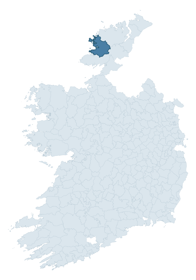
Where this barony sits in the Republic of Ireland
Geology and preservation
Bedrock geology shapes the landscape long before any settlement begins — controlling soil drainage, agricultural potential, the survival of upstanding monuments, and the preservation of buried archaeology. The figures below come from the Geological Survey Ireland 1:100,000 bedrock map.
The bedrock underlying Boylagh is predominantly granite (43% of the barony by area), laid down during the Silurian-Devonian period (64% by area, around 444 to 359 million years ago). Granite weathers slowly and produces thin, acidic, often poorly-drained soils that historically limited arable agriculture but favoured pastoralism, upland settlement, and the construction of stone monuments. Granite-dominated landscapes typically carry fewer ringforts but a higher density of megalithic tombs, standing stones, and stone circles, which survive well against the resistant bedrock. With 14 distinct rock types mapped, the barony sits in the top third of ROI baronies for geological diversity (98th percentile) — typically a sign of complex tectonic history or coastal mosaics of differing rock units.
Rock type composition
Largest mapped unit: Main Donegal Granite (22% of the barony)
Placename evidence
Logainm records 25 heritage-diagnostic placenames for Boylagh, drawn from townland and civil-parish names across the barony. The dominant stratum is Early Christian ecclesiastical — cill-, teampall-, and domhnach-prefixed names that record the dense network of early church foundations established between the fifth and tenth centuries. The leading diagnostic roots are cill- (10 — church), dún- (3 — hilltop fort or promontory fort), and ráth- (2 — earthen ringfort). This is broadly in line with the ROI average of 30.7 heritage placenames per barony. The presence of multiple heritage strata side by side indicates layered occupation of the landscape across successive prehistoric and historic periods. Logainm records 258 placenames for Boylagh (predominantly townland names). Of these, 25 (10%) carry one of the diagnostic Gaelic roots tracked above; the remainder draw on more generic landscape vocabulary that does not encode a heritage period.
Pre-Christian / Early Medieval Defensive
| Root | Count | Meaning |
|---|---|---|
| dún- | 3 | hilltop or promontory fort |
| ráth- | 2 | earthen ringfort |
| caiseal- | 2 | stone ringfort |
| lios- | 1 | ringfort or enclosure |
Early Christian Ecclesiastical
| Root | Count | Meaning |
|---|---|---|
| cill- | 10 | church (early) |
| teampall- | 1 | church (later medieval) |
| tobar- | 1 | holy well |
Burial, Ritual, and Norse-Contact
| Root | Count | Meaning |
|---|---|---|
| carn- | 2 | cairn |
| tuaim- | 1 | burial mound |
| dumha- | 1 | mound |
| leacht- | 1 | grave monument |
| gall- | 1 | foreigner — Norse settlement marker |
Other baronies in Donegal
About this profile
Click any section below to expand.
What is a barony?
A barony is a historic administrative unit in Ireland, broadly equivalent to an English hundred. The 280 baronies used here are from the OSi 2019 National Statutory Boundaries (generalised 20m), covering the 26 counties of the Republic of Ireland. Baronies derive from the Norman period, were formalised in the 17th century, and have not been redrawn for statistical purposes. They vary enormously in area, from compact urban baronies in Dublin to vast upland baronies in Connacht, and should not be compared by raw site count without accounting for area differences.
What counts as a site?
This profile combines three distinct heritage registers, each with its own definition of what constitutes a recordable site:
- Archaeological sites (NMS). The National Monuments Service Sites and Monuments Record (SMR) catalogues every known archaeological monument or site of archaeological interest in the Republic, from prehistoric burial mounds and ringforts to medieval churches and post-medieval defensive works. Inclusion does not require legal protection — only that the site has been identified, surveyed, and assessed as having archaeological value. A separate subset of these sites lies within a recorded protection zone, which gives them statutory protection under the National Monuments Acts.
- Listed buildings (NIAH). The National Inventory of Architectural Heritage records buildings of architectural, historical, archaeological, artistic, cultural, scientific, social, or technical interest. Each surveyed structure is appraised on a five-tier scale: International, National, Regional, Local, and Record-Only. The NIAH appraisal is informational rather than strictly statutory, but it underpins local-authority Record of Protected Structures (RPS) listings.
- Heritage placenames (Logainm). Logainm is the authoritative database of Irish placenames maintained by the Placenames Branch. This profile applies a heritage-diagnostic classifier to the Irish-language form of each townland name, flagging roots that signal defensive sites (ráth-, lios-, dún-, caiseal-, cathair-), ecclesiastical foundations (cill-, teampall-, domhnach-, mainistir-), prehistoric burial-ritual features (tuaim-, carn-, leaba-), or Norse-contact settlement (gall-). Townlands without one of these diagnostic roots are not flagged here — they may still carry historical significance, but that significance is not encoded in the name itself.
Editorial principles
The narrative sections of this profile follow several explicit principles:
- Evidential. Every claim about this barony’s heritage character is anchored in the underlying register data. Where a site count, a placename count, or a percentile rank is cited, it is computed from the source datasets at export time, not estimated.
- Comparative. Counts and metrics are reported alongside their percentile rank against the other 279 ROI baronies. A barony with 50 ringforts in absolute terms could be unusually high or unusually low depending on its size and regional context; percentile ranking removes that ambiguity.
- Transparent on limits. Where a register has known coverage gaps, survey biases, or data-quality issues that affect this barony’s figures, the profile flags them rather than presenting the numbers as definitive.
- No interpretation beyond what the data supports. The narrative does not speculate about historical events, social dynamics, or cultural meaning beyond what the recorded heritage and placename evidence directly attests.
Data caveats and limits
- NMS Sites and Monuments Record is the product of survey campaigns conducted at different intensities across different counties and decades. Some baronies have been surveyed more thoroughly than others, and absolute counts should be read in that light. Sites destroyed by development before survey are typically not represented; sites in heavily forested or upland terrain are sometimes under-recorded.
- NIAH coverage is broadly complete for the Republic of Ireland but the survey was conducted on a rolling county-by-county basis, and the most recent appraisal date varies. Buildings demolished or substantially altered after their original survey may still appear in the register; conversely, recent buildings of merit may not yet have been appraised.
- Logainm classification applies a deliberately conservative pattern-matching approach to the Irish-language townland forms. The classifier prioritises true positives over recall: a townland may carry a heritage signal that the classifier doesn’t recognise, particularly where the diagnostic root has been heavily anglicised or where the townland name draws on a less common term. The 60,000+ townland records and ~9,800 classified placenames give a substantial signal at barony scale, but individual townland names should be checked against Logainm directly for definitive interpretation.
- Period attribution. The chronological distribution reflects only those NMS sites that carry a recognised period attribution in the source data. Sites listed as “Unknown” period are excluded from the dated subset.
- Boundary changes. Some baronies have undergone minor boundary adjustments since their 19th-century definition; the OSi 2019 generalised boundaries used here are the current statutory definition and may differ slightly from historical maps in border areas.
- Bedrock geology is mapped at 1:100,000 scale, which means local variation within a barony — small pockets of different rock type, mineral veins, alluvium overlying bedrock — is generalised. The dominant-system and rocktype figures are area-weighted, so a barony reading “70% Carboniferous limestone” may still contain small but archaeologically important pockets of older or younger rock. Around 3% of GSI polygons do not match the lexicon and contribute no rocktype or system attribution.
Data sources
- National Monuments Service — Sites and Monuments Record (SMR) https://data.gov.ie/dataset/national-monuments-service-archaeological-survey-of-ireland
- National Inventory of Architectural Heritage (NIAH) https://data.gov.ie/dataset/national-inventory-of-architectural-heritage-niah-national-dataset
- Logainm — Placenames Database of Ireland https://www.logainm.ie/
- Ordnance Survey Ireland — National Statutory Barony Boundaries 2019 https://data-osi.opendata.arcgis.com/
- EURODEM — European Digital Elevation Model https://www.mapsforeurope.org/datasets/euro-dem
- ESA WorldCover https://esa-worldcover.org/en
- Geological Survey Ireland — 1:100,000 Bedrock Geology https://www.gsi.ie/en-ie/data-and-maps/Pages/Bedrock.aspx
Explore more: Search any of the 280 ROI baronies, browse by historical province, or read the methodology and data sources for the full Republic of Ireland Heritage Tool.