
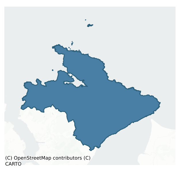
Inishowen East is a barony of County Donegal, in the historical province of Ulster (Irish: Inis Eoghain Thoir), covering 501 km² of land. The barony records 599 NMS archaeological sites and 406 NIAH listed buildings, placing it at around the 19th percentile among 280 ROI baronies for sites per km². This means it is in the bottom fifth of all baronies for sites per km². Dated archaeological evidence runs from the Mesolithic through to the Modern, spanning 9 of 9 archaeological periods, placing the barony in the 94th percentile among 280 ROI baronies for chronological depth. This means it is in the top tenth of all baronies for chronological depth. The largest dated subset of recorded sites dates to the Early Medieval.
Heritage at a glance
Percentile rankings throughout this profile compare each barony only against the other 279 Republic of Ireland baronies.
The recorded heritage of Inishowen East
The National Monuments Service Sites and Monuments Record (SMR) is the statutory inventory of archaeological sites for the Republic of Ireland, maintained by the Department of Tourism, Culture, Arts, Gaeltacht, Sport and Media. Sites recorded here include earthworks, ringforts, megalithic tombs, ecclesiastical remains, and post-medieval features; not every record is legally protected, but each is registered as a monument of archaeological interest.
The National Monuments Service records 599 archaeological sites in Inishowen East, putting it at the 19th percentile among 280 ROI baronies for sites per km². This means it is in the bottom fifth of all baronies for sites per km². Protection coverage is near-universal — 563 sites (94%) fall within a recorded monument protection zone, indicating an extensively surveyed landscape. The record is dominated by prehistoric ritual monuments — standing stones, stone circles, and rock art (180 sites, 30% of the total), with defensive sites forming a substantial secondary presence (98 sites, 16%). Rock art is the most prevalent type, making up 21% of the barony's recorded sites (123 records) — well above the ROI average of 4% across all baronies where this type occurs. Rock art is geometric and other motifs carved on earthfast boulders or rock outcrops, mainly Bronze Age but with possible Neolithic origins. Other significant types include Standing stone (55) and Ringfort – rath (23). Standing stone is a deliberately set upright stone, used variously as a Bronze/Iron Age burial marker, route marker or commemorative monument; Ringfort – rath is an earthen ringfort enclosed by a bank and external ditch — the most common Early Medieval farmstead, broadly dated 500–1000 AD. Across the barony's 501 km², this gives a recorded density of 1.19 sites per km².
Most common monument types
Hover or tap a monument type to see its definition.
| Type | Count |
|---|---|
| Rock art geometric and other motifs carved on earthfast boulders or rock outcrops, mainly Bronze Age but with possible Neolithic origins | 123 |
| Standing stone a deliberately set upright stone, used variously as a Bronze/Iron Age burial marker, route marker or commemorative monument | 55 |
| Ringfort – rath an earthen ringfort enclosed by a bank and external ditch — the most common Early Medieval farmstead, broadly dated 500–1000 AD | 23 |
| Cross-slab a stone slab inscribed with a cross, used as a grave-marker or memorial, dated pre-1200 AD | 20 |
| Ringfort – cashel the stone-walled equivalent of the rath, found mainly in upland or western areas, broadly dated 500–1000 AD | 20 |
| Cairn – unclassified a stone mound that cannot be assigned to a specific cairn type | 18 |
| Souterrain an underground stone-built passage and chamber, generally Early Medieval and often associated with ringforts as a defensive or storage feature | 18 |
| Ritual site – holy well a well or spring traditionally associated with a saint, often credited with healing properties; many trace earlier ritual origins but devotion is documented from the medieval period onwards | 17 |
Chronological distribution
The dated archaeological record for Inishowen East spans from the Mesolithic through to the Modern, with activity attested across 9 of 9 archaeological periods. This places Inishowen East in the top 6% of ROI baronies for chronological depth — few baronies record evidence across as many distinct archaeological periods. Every period from earliest to latest is represented in the record — an unbroken sequence of dated activity across the full chronological span. Activity concentrates most heavily in the Early Medieval (124 sites, 32% of dated material), with the Early Bronze Age forming a secondary peak (109 sites, 28%). A further 207 recorded sites (35% of the overall NMS register for the barony) carry no period attribution — appearing as 'Unknown' in the bar chart below. This typically reflects either records that pre-date the standardised period vocabulary or sites awaiting specialist dating review, rather than a genuine absence of chronological evidence.
Sample of recorded monuments
Show 25 sample monuments (of 599 total)
A representative sample of 25 recorded monuments drawn from the barony’s 599 total NMS entries. Sites within a recorded monument protection zone and rarer site types are prioritised so the list shows a meaningful cross-section rather than only the most common type. Each entry shows the official Sites and Monuments Record reference number and the description published by the National Monuments Service.
Cave
Cut into a rock face on the N shoreline of Malin Head.
Recorded by the Donegal Survey (Lacy et al 1983, 242, no. 1516) as follows: To the SW of the church (DG002-002001-) is a rock-cut cave, known as the 'Wee House…
Cut into a rock face on the N shoreline of Malin Head.
Recorded by the Donegal Survey (Lacy et al 1983, 242, no. 1516) as follows: To the SW of the church (DG002-002001-) is a rock-cut cave, known as the 'Wee House of Malin'. It is 1.3m across the opening which has been partly built up with stones allegedly from the church. It is 2.75m deep and 2.25m high. To the E of the church along the shore is a holy well (DG002-003—-).
The following details have been kindly supplied by Dr Marion Dowd (August 2013):
This small cave (2.75m long x 1.3m wide x 2.25m high) is located on the seashore at Malin. It is partially, if not entirely, artificially rock-cut and a relatively modern wall has been constructed across the entrance. The cave is associated with a holy well (DG002-003—-) known as Malin Well or Tobar Muireadagh and a Medieval church (DG002-002001-) known as Gorman Church (Lacy et al. 1983, 242). All three sites are associated with St. Muirdhealach, a hermit who is said to have lived in The Wee House of Malin (Ó Muirgheasa 1936, 160-1; Fitzgerald n.y., 2). Local tradition claims that the cave ‘holds all that goes into it, and the more goes into it, it holds the more’ (Beattie et al. 2000, 40). The pátrún to the site, known as Malin Well Fair, was held on the 15th of August but formerly on the 1st May and at midsummer (Ó Muirgheasa 1936; Fitzgerald n.y., 2). Pilgrims bathed in the holy well and prayed in the cave (Logan 1980, 61). The date at which this cave came t…
Castle – tower house
Carrickabraghy Castle: Probably 16th century in date this tower-house was occupied by Phelemy Brasleigh O'Doherty in 1600. Granted to Chichester at the time of the Plantation in 1611, it was let to 'Liuetent Hoan, who…
Carrickabraghy Castle: Probably 16th century in date this tower-house was occupied by Phelemy Brasleigh O'Doherty in 1600. Granted to Chichester at the time of the Plantation in 1611, it was let to 'Liuetent Hoan, who is bound to rebuild the castle. He hath already finished a good bawne (DG003-002002-) of lyme and stone' (Davies and Swan 1939, 195-7; Hunter 1975, 82). It is prominently sited on a high promontory of outcrop on the seashore. The keep is small and built of rubble with ashlar quoins laid in a coarse sea-sand mortar; the walls are of uneven thickness and are battered to first-floor level. A ragged opening in the E wall is probably the site of the door and some protruding stones at ground level are probably the footings of the splayed ingoings. There is a splayed window (jambs missing) in the S wall and a wall-press at the SW comer. The N section of the embrasure in the N wall has been completely rebuilt and incorporates a small loop. There is a scarcement at first-floor level and the opposing holes for three joists survive in the E and W walls. Centrally set in the W wall is a large wall-press, 1.15m high with a smaller extension to the S .35m high, built in the thickness of the wall. The segment-headed embrasure in the S wall preserves impressions of the wicker centering on the soffit; it has a small loop. There is another splayed loop in the E wall and a doorway and window (jambs missing) in the N wall. The stairs in the thickness of this wall led to the floo…
Megalithic tomb – portal tomb
The monument, c. 3km W of Culdaff, is prominently sited toward the western end of a boggy ridge broken by rock outcrops. To the S and W is a fall to lower ground mainly devoted to pasture. The sea inlet of Trawbreaga…
The monument, c. 3km W of Culdaff, is prominently sited toward the western end of a boggy ridge broken by rock outcrops. To the S and W is a fall to lower ground mainly devoted to pasture. The sea inlet of Trawbreaga Bay, 4km distant, is visible to the W.
The tomb consists of a small SE-facing chamber, the front of which has collapsed. The chamber was at least 1.8m long and is 1 m wide at the rear. A backstone at the NW and two opposed sidestones are in place. A displaced roofstone, its front end resting on the ground, is supported on the outer end of the southern sidestone and on a small stone (not on plan) on top of the northern sidestone. A prostrate stone in front of the southern sidestone appears to be a displaced portal-stone. It measures 2m by 0.65m by 0.2m thick. This seems to be the stone referred to in an OS Revision Name Book (1848) as 'an upright stone 4 feet [c. 1.2m] high which appears to have originally supported the covering stone but having leaned a little toward the south by some unknown cause leaves one end of the covering stone resting on the ground'. Some loose stones (not on plan) lie in the chamber. A slightly raised grassy patch, c. 5m across, alongside the southern sidestone may be the remains of an enclosing mound.
The backstone, set between the ends of the sidestones, leans inward slightly and is gabled in profile. It is 0.6m high, c. 0.3m lower than the sidestones, both of which lean in against it. The southern sidestone is 0.9m high. The nort…
Pillar stone
Templemoyle ecclesiastical complex consists of a modern rectangular graveyard 22m N-S, 20.5m E-W. To the N is a sub-rectangular area 12m E-W, 10.4m N-S with a level interior enclosed by a stone wall 1m high…
Templemoyle ecclesiastical complex consists of a modern rectangular graveyard 22m N-S, 20.5m E-W. To the N is a sub-rectangular area 12m E-W, 10.4m N-S with a level interior enclosed by a stone wall 1m high (DG004-052001-). There is a possible entrance to the S. E of this is a D-shaped mound (DG004-052008-) of earth and stone, up to 1.5m high and 8m in diameter with its flat edge to the E. Abutting this mound on its W side is a small circular stone foundation (DG004-052002-) 2.2m in diameter. A small stone cross (DG004-052003-) stands in the interior. Nearby, but now destroyed was a holy well (DG004-052004-) and a dallan or pillar stone (DG004-052007-) dedicated to St. Adomnán (Ó Muirgheasa No. 92).
The above description was derived from the 'Archaeological Survey of County Donegal. A description of the field antiquities of the County from the Mesolithic Period to the 17th century.' Compiled by: Brian Lacey with Eamon Cody, Claire Cotter, Judy Cuppage, Noel Dunne, Vincent Hurley, Celie O'Rahilly, Paul Walsh and Seán Ó Nualláin (Lifford: Donegal County Council, 1983). In certain instances the entries have been revised and updated.
Date of upload: 22 September 2008
Ritual site – holy/saint's stone
This is believed to be the early ecclesiastical site of Culmaine (Gwynn and Hadcock 1970, 377). The site presently consists of a graveyard (DG010-011001-) surrounding a ruined 18th century church. 14m from the SE corner…
This is believed to be the early ecclesiastical site of Culmaine (Gwynn and Hadcock 1970, 377). The site presently consists of a graveyard (DG010-011001-) surrounding a ruined 18th century church. 14m from the SE corner of the church is a flat-surfaced stone, .3m x .52m, on which are two small cupmarks. Traditionally these are known as St. Colmcille's knee-prints (DG010-011002-). It is situated in a band of good land in generally rough pasture sloping NE to the Clonmany river. Beside the church there stood in 1600 a castle (DG010-011004-) (probably a stone house) which was inhabited by a priest called Amerson (Davies and Swan 1939, 198). No visible trace of this structure survives and its exact location is unknown.
The above description was derived from the 'Archaeological Survey of County Donegal. A description of the field antiquities of the County from the Mesolithic Period to the 17th century.' Compiled by: Brian Lacey with Eamon Cody, Claire Cotter, Judy Cuppage, Noel Dunne, Vincent Hurley, Celie O'Rahilly, Paul Walsh and Seán Ó Nualláin (Lifford: Donegal County Council, 1983). In certain instances the entries have been revised and updated.
Date of upload: 22 September 2008
Anomalous stone group
This feature, named 'Darby's Bed' on the original edition of the OS 6-inch map (1834), is shown but not named on the revised 6-inch map of 1848. It stands at the western edge of a stream and consists of two stones at…
This feature, named 'Darby's Bed' on the original edition of the OS 6-inch map (1834), is shown but not named on the revised 6-inch map of 1848. It stands at the western edge of a stream and consists of two stones at right angles to each other. The larger one, an upright slab, lies ENE-WSW and is 1.07m long, 0.2m thick and 1m high. The smaller stone is just S of the eastern end of the larger. This is a low stone, 1m long, 0.5m thick and 0.3m high. The nature of this artificial feature is unclear.
Borlase 1897, 229, Inishowen East no. 7; Lacy 1983, 88, no. 501; Ó Nualláin 1983a, 49, no. 184 (the description here arose from a misidentification of the site); SMR 1987, 10:20; RMP 1995, 10:20.
The above description was published in the 'Survey of the Megalithic Tombs of Ireland. Volume VI, County Donegal.' Compiled by: Eamon Cody (Dublin: Stationery Office, 2002).
Date of upload: 22 September 2008
Crannog
A small island in Lough Fad 14m N-S × 13m E-W apparently consisting of an artificial mound of stones rises 1m out of the water at present.
The above description was derived from the 'Archaeological Survey of County…
A small island in Lough Fad 14m N-S × 13m E-W apparently consisting of an artificial mound of stones rises 1m out of the water at present.
The above description was derived from the 'Archaeological Survey of County Donegal. A description of the field antiquities of the County from the Mesolithic Period to the 17th century.' Compiled by: Brian Lacey with Eamon Cody, Claire Cotter, Judy Cuppage, Noel Dunne, Vincent Hurley, Celie O'Rahilly, Paul Walsh and Seán Ó Nualláin (Lifford: Donegal County Council, 1983). In certain instances the entries have been revised and updated.
Date of upload: 22 September 2008
Architectural feature
The Carndonagh complex (National Monument number 271) is the site of one of the main early ecclesiastical centres in Donegal. It consists of a modern graveyard (DG011-035007-) surrounding the 18th century Church of…
The Carndonagh complex (National Monument number 271) is the site of one of the main early ecclesiastical centres in Donegal. It consists of a modern graveyard (DG011-035007-) surrounding the 18th century Church of Ireland church. The W entrance of the church consists of a reused 15th-century door with pointed head (DG011-035002-). The jambs are stop-chamfered with a central right-angled groove, suggestive of two orders. Each of the tapering stops of the chamfered hood-mould terminates in a small moulded band, now defaced, from which a double vine leaf and single vine bunch enrichment springs. The door has been heightened by the insertion, in the jambs, of two dressed blocks below the hood-mould stops, and two others below the chamfer stops. To the S of this doorway and lying against the church wall is a small carved stone (DG011-035003-). On the face of this is a central wheeled cross, three or four figures on the left and interlacing on the right. It is, presumably, a lintel from an earlier church (DG011-035001-).
The above description was derived from the 'Archaeological Survey of County Donegal. A description of the field antiquities of the County from the Mesolithic Period to the 17th century.' Compiled by: Brian Lacey with Eamon Cody, Claire Cotter, Judy Cuppage, Noel Dunne, Vincent Hurley, Celie O'Rahilly, Paul Walsh and Seán Ó Nualláin (Lifford: Donegal County Council, 1983). In certain instances the entries have been revised and updated.
Date of upload/revis…
Penitential station
Carrowmore ecclesiastical complex has been identified with Both Chonais an early monastic site (Gwynn and Hadcock 1970, 30). The site consists of a series of monuments (DG011-049—-/049010-) divided by a modern road,…
Carrowmore ecclesiastical complex has been identified with Both Chonais an early monastic site (Gwynn and Hadcock 1970, 30). The site consists of a series of monuments (DG011-049—-/049010-) divided by a modern road, but obviously it originally formed part of a larger unit. On the W side of the road there is a rectangular enclosure of a burial ground (DG011-049001-). Near the SW corner of the enclosure two jamb-stones 1.5m apart, and at right-angles to the line of the wall, probably indicate an entrance. Just beyond the N side of this wall is a flat-topped boulder (DG011-049003-) which may be the base of a high cross. Inside the dividing wall is a possible cross-slab (DG011-049004-) partially buried in the ground. Also close to the S end is a tall plain cross (DG011-049005-). E of the road is a second cross (DG011-049006-). There is a small cairn possibly a penitential cairn of stones about the base of the cross. This cairn is marked on the 1903 ed. OS 6-inch map (Lacy et. al. 1983, 248). 18m to the S there is an earth-fast cross-inscribed boulder (DG011-049008-). To the NE against a field and townland boundary there was a holy well (DG012-021—) which has been closed up (Ó Muirgheasa, No. 94). In 2012 the Bernician Studies Group carried out a magnetometer survey in the fields surrounding the high crosses (DG011-049005-/006-) at Carrowmore which revealed the sub-surface remains of a bi-vallate early Christian ecclesiastical enclosure (DG011-049—-) (O'Brien and Ada…
Inscribed stone
Set into the wall of Clonca church (DG012-002001-), National Monument (no. 25).
Built into the external wall face at the N end of the W wall is a small stone (L 0.32; H 0.15m) bearing a mallet and chisel device above…
Set into the wall of Clonca church (DG012-002001-), National Monument (no. 25).
Built into the external wall face at the N end of the W wall is a small stone (L 0.32; H 0.15m) bearing a mallet and chisel device above a now fragmentary inscription which reads: '(. . . . . .) An O'Dubdagan do Ri (gne. . . . . . cl) og so do Domnall o (R. . . . . .)’ [Translation: …O'Dubdagan who made. . . this stone for Domnall O R]. (Macalister 1949, 115-6, No. 948).
The above description is derived from the 'Archaeological Survey of County Donegal. A description of the field antiquities of the County from the Mesolithic Period to the 17th century.' Compiled by: Brian Lacy with Eamon Cody, Claire Cotter, Judy Cuppage, Noel Dunne, Vincent Hurley, Celie O'Rahilly, Paul Walsh and Seán Ó Nualláin (Lifford: Donegal County Council, 1983). In certain instances the entries have been revised and updated.
Attached images:
DG012-002003_01.JPG
DG012-002003_02.JPG
Date of upload: 22 September 2008
Building
A standing stone is marked here on the OS 6-inch maps. It is 1.96m high. The stone stands in the midst of a large complex of stone field walls and stone enclosures some of which are buried under or sticking up out of…
A standing stone is marked here on the OS 6-inch maps. It is 1.96m high. The stone stands in the midst of a large complex of stone field walls and stone enclosures some of which are buried under or sticking up out of the bog. It is not possible to say to what extent these are associated with, or are of similar date to, one another. A modern field boundary divides the area and is built of stone similar to those buried in the bog. It is likely that this was, at least in part, constructed by robbing the earlier structures. (b) S of the modern wall is a series of walls and enclosures all definitely associated. Some are buried up to 1m in the bog and have been revealed by probing. Other sections of this series are visible in turf cuttings and at the edges of the bog, where it is less deep and peters out. The series consists of a number of small 'fields' and two small oval cairns, 6m × 4m and 8m × 3m. A larger semicircle of stones to the N fades out on the S side of the modern field wall. It is now c. 32m in diameter. (c) To the N of the modern field boundary is a second series of walls and enclosures. These are distributed about the standing stone (a) above. W of this standing stone are three other stones standing in a roughly N-S line. To the S of these is a large circular stone enclosure c. 35m in diameter. A stone wall divides this enclosure N-S into an eastern 2/3 and a western 1/3. The wall stops c. 6m from the S side of the enclosure. On the N side, between the enclosure…
Cross-inscribed pillar (present location)
A cross-inscribed pillar stone (DG012-017001-) 1.1m high × 0.39m maximum width at the upper half. There is a plain Latin cross with a T-bar terminal at the bottom, and the upper half of a circle joining the top and the…
A cross-inscribed pillar stone (DG012-017001-) 1.1m high × 0.39m maximum width at the upper half. There is a plain Latin cross with a T-bar terminal at the bottom, and the upper half of a circle joining the top and the two arms. There is another complete circle in the centre at the point where the arms cross the shaft. The cross is .5m high × 0.24m across the arms. It is now situated in a field wall, but was originally sited in the centre of the field known as 'Lacht Field'. There was a cairn (DG012-017002-) some 6ft high associated with it; this has now disappeared. Flat grazing land, overlooking Tremone Bay, some distance to the North.
The above description was derived from the 'Archaeological Survey of County Donegal. A description of the field antiquities of the County from the Mesolithic Period to the 17th century.' Compiled by: Brian Lacey with Eamon Cody, Claire Cotter, Judy Cuppage, Noel Dunne, Vincent Hurley, Celie O'Rahilly, Paul Walsh and Seán Ó Nualláin (Lifford: Donegal County Council, 1983). In certain instances the entries have been revised and updated.
Date of upload: 22 September 2008
Shrine
The early ecclesiastical site here consists of a sub-rectangular shaped graveyard inside of which are a number of earlier features. The site is located on excellent land sloping to Lough Foyle to the E and is…
The early ecclesiastical site here consists of a sub-rectangular shaped graveyard inside of which are a number of earlier features. The site is located on excellent land sloping to Lough Foyle to the E and is traditionally claimed to have been founded by St. Patrick (Gwynn and Hadcock 1970, 399; Lacy et. al. 1983, 261). To the W outside the entrance to the graveyard (DG021-008001-) is a tall, plain, ringed high-cross (DG021-008005-). Inside the graveyard are the remains of two churches (DG021-008002-/003-) and a mortuary house or tomb shrine (DG021-008004-). One of the churches served as a medieval parish church (Leslie 1937, 265).
Mortuary House or tomb shrine known locally as the 'Skull House' (DG021-008004-): NE of the South Church (DG021-008002-) is a small gabled structure with a stone roof, built of rubble masonry 2.6m × 1.8m externally. The gable is 2m high. It contains a single chamber with a corbelled roof rising to a central capstone. The E wall has a small light 0.38m × 0.12m with slightly splayed ingoings. There is a small lintelled door 0.37m square in the W gable (Waterman 1960, 82-8). E of the Mortuary House is a small basin stone or possible bullaun stone (DG021-008007-) and to the NW a small cross-inscribed stone (DG021-008006-). A fragment of a cross-slab (DG021-008018-) with a wheeled-cross was found lying in the interior of the South Church.
The above description was derived from the 'Archaeological Survey of County Donegal. A description…
Bridge
In the grounds of Gulladoo House are three bridges. Two of them cross the River Bredagh which goes through a U-turn at this point. The river no longer passes under the third bridge. This was pointed out to us as the…
In the grounds of Gulladoo House are three bridges. Two of them cross the River Bredagh which goes through a U-turn at this point. The river no longer passes under the third bridge. This was pointed out to us as the 'Old Bridge' which previous authorities had attributed to the sixth, eight or ninth centuries (Swan 1949, 31). It consists of four bays, each c. 1m in width separated by three rectangular masonry pillars c. 0.5m in width and with the ends of the bridge resting on the banks. The pillars were pointed to deflect the water flow on their N side but only the pointing of the W pillar survives. They now stand c. 1m in height above the silted-up bed. On these are laid grass-grown slab-stones. The bridge is c. 2.5m in width. The bridge gives access now only to a field, but points in the general direction of Cooley graveyard (DG021–008001-) three quarters of a mile to the W. It seems clear that Swan, in describing 'The Arch' with 'Wattle marks', is referring to the small bridge leading to the house. It is difficult to assess the antiquity of any of these bridges but a pre-medieval date for that described above seems unlikely. It is situated in good land near the SE end of Breadth Glen where the river enters Lough Foyle close to the town of Moville.
The above description was derived from the 'Archaeological Survey of County Donegal. A description of the field antiquities of the County from the Mesolithic Period to the 17th century.' Compiled by: Brian Lacey with Eamon…
Cross-slab (present location)
Situated in the parochial house, Moville for safe keeping. Small cross-slab, measuring 0.61m long by 0.15m widest. It tapers to 0.08m at the end. The cross is carved on the upper (wider) end and is 0.37m long x 0.14m…
Situated in the parochial house, Moville for safe keeping. Small cross-slab, measuring 0.61m long by 0.15m widest. It tapers to 0.08m at the end. The cross is carved on the upper (wider) end and is 0.37m long x 0.14m across. It is a latin wheeled cross (raised). The shaft is 0.04m wide, while the top and arms 0.03m and 0.025m respectively. The wheel is 0.017m wide. There is a groove in the centre of the wheel which doubles at the 2 arms and top and extends down the shaft for a distance of 0.085m. This doubling at the arms top and shaft has the effecet of creating an inner cross which has an expanded (sq.) at the centre. There is some damage to the lower end of the shaft. The cross originally came from Glennagiveny (DG013-003002-) and was dug up from about 3ft under the soil (Donegal Archaeological Survey).
Castle – Anglo-Norman masonry castle
Greencastle: Greencastle was the principal Norman castle in NW Ulster and was built by the 'Red' Earl of Ulster, Richard de Burgo, in 1305. The castle, then known as Northburgh or Newcastle, was captured by the Scots in…
Greencastle: Greencastle was the principal Norman castle in NW Ulster and was built by the 'Red' Earl of Ulster, Richard de Burgo, in 1305. The castle, then known as Northburgh or Newcastle, was captured by the Scots in 1316 during the invasion of Ireland by Edward Bruce. On the defeat of Bruce two years later, the castle reverted to the Earl and on his death passed to his grandson, the 'Brown' Earl. When he was murdered in 1333, the de Burgo influence in Ireland collapsed. The lordship of Inishowen finally passed to the O'Donnells in the early 15th century, and their dependants, the O'Dohertys, established themselves at Greencastle. It was considerably damaged in 1555 as a result of an internecine war among the O'Donnells, but was still wardable in 1586. Granted to Chichester, the Lord Deputy, at the time of the Plantation, it is recorded in 1611 that 'There was one hundred men's worke 20 wicks bestowede in cleeringe the ruynes of Green Castle'. Chichester maintained a small garrison there and in 1623, in a report on the repair of forts, Greencastle was described as 'fitter for a ward than Culmore'. It subsequently went into decline and was abandoned and allowed to decay (Waterman 1958, 74-5; Hunter 1975, 82).
Situated on the W shore of Lough Foyle, the site encompasses a massive platform of cropping rock whose cliffs and fissured slopes on the SE and S afforded protection on these sides. The upper ward (DG022-003001-) of the castle with its massive NE polygonal tower wa…
Font (present location)
A short right-angled stretch of masonry in the graveyard (DG004-005003-) adjacent to the modern church seems to be all that survives of a pre-17th century church (DG004-005001-) here. A small stone cross (DG004-005002-)…
A short right-angled stretch of masonry in the graveyard (DG004-005003-) adjacent to the modern church seems to be all that survives of a pre-17th century church (DG004-005001-) here. A small stone cross (DG004-005002-) stands to the N of these remains. It is situated in a natural enclosure of the sandhills to the N of the channel to Trawbreaga Bay. Just outside the door of the modern church is a painted stone font (DG004-007-), hexagonal in shape, c. 0.5m across with a hollow .3m in diameter and 0.2m deep. It is believed to have originally come from Fahan (DG038-013001-).
The above description was derived from the 'Archaeological Survey of County Donegal. A description of the field antiquities of the County from the Mesolithic Period to the 17th century.' Compiled by: Brian Lacey with Eamon Cody, Claire Cotter, Judy Cuppage, Noel Dunne, Vincent Hurley, Celie O'Rahilly, Paul Walsh and Seán Ó Nualláin (Lifford: Donegal County Council, 1983). In certain instances the entries have been revised and updated.
Date of upload: 22 September 2008
House – 18th/19th century
This is Whitecastle, 'a late 18th century house' (Rowan 1979, 477).
The above description was published in the 'Archaeological Survey of County Donegal. A description of the field antiquities of the County from the…
This is Whitecastle, 'a late 18th century house' (Rowan 1979, 477).
The above description was published in the 'Archaeological Survey of County Donegal. A description of the field antiquities of the County from the Mesolithic Period to the 17th century.' Compiled by: Brian Lacey with Eamon Cody, Claire Cotter, Judy Cuppage, Noel Dunne, Vincent Hurley, Celie O'Rahilly, Paul Walsh and Seán Ó Nualláin (Lifford: Donegal County Council, 1983).
Date of upload: 22 September 2008
Leacht
'Kilblaney Burial Ground' (DG022-002005-) consists of a subrectangular enclosure c. 25m E-W and c. 15m N-S defined on three sides by a wall and on the fourth by a cliff edge. Near the centre of the graveyard are three…
'Kilblaney Burial Ground' (DG022-002005-) consists of a subrectangular enclosure c. 25m E-W and c. 15m N-S defined on three sides by a wall and on the fourth by a cliff edge. Near the centre of the graveyard are three drystone walls each c. 1m wide and 0.8m high forming a rectangle, 4m N-S and. 5m E-W internally, open to the W end. This is said to be the remains of a 'church' (DG022-002001-) but may alternatively be the remains of a small drystone enclosure. In the NE quadrant of this structure there are the remains of a low rectangular flat-topped rubble cairn known as an 'altar' (DG022-002007-) which may be the remains of a leacht (ext. dims. 1.75m E-W by 2.8m N-S; H 0.5m). The rectangular shaped leacht is defined by a series of low orthostats set on edge forming a rectangular area which is infilled with smaller stones and appears to have been roofed by a series of capstones (L 1.05m; Wth 0.39m) of which only one survives in situ. On the W edge of the leacht there is a pillar stone (DG022-002002-), (dims. H 0.85m × T .26m to .33m). On the W face of the pillar stone a plain Latin cross (DG022-002004-) has been hollowed out of the surface of the stone which gives the cross a sunken appearance. Beside this slab and lying on top of the leacht there was a quern-stone that has since been moved to the maritime museum in Greencastle. Just N of the entrance on the W side of the graveyard is a small, stone cross (DG022-002004-) supported by one half of a stone socket. There are ma…
Cross – High cross (present location)
This monument number records the present location of a high cross, which is a National Monument in state ownership (no. 271). The high cross, and the two stone sculptures (DG011-035010-; DG011-035011-) associated with…
This monument number records the present location of a high cross, which is a National Monument in state ownership (no. 271). The high cross, and the two stone sculptures (DG011-035010-; DG011-035011-) associated with it, were moved to this location to protect them from erosion. The original location of these monuments, indicated as ‘Cross’ on the 183 and 1903 OS 6-inch maps, is recorded under the numbers: DG011-035005-; DG011-035007-; DG011-035008-.
The following description is derived from the 'Archaeological Survey of County Donegal. A description of the field antiquities of the County from the Mesolithic Period to the 17th century.' Compiled by: Brian Lacey with Eamon Cody, Claire Cotter, Judy Cuppage, Noel Dunne, Vincent Hurley, Celie O'Rahilly, Paul Walsh and Seán Ó Nualláin (Lifford: Donegal County Council, 1983):
The Carndonagh complex (National Monument number 271) is the site of one of the main early ecclesiastical centres in Donegal. It consists of a modern graveyard (DG011-035007-) surrounding the 18th century Church of Ireland church. At the NE corner of the graveyard but outside it on the roadside is a group of carved stones consisting of a cross (DG011-035009-) flanked on each side by a stele, one to the N (DG011-035010-) and the other to the S (DG011-035011-). This group originally stood c. 20m NE on the opposite side of the road. The cross which is c. 2.5m high, c. 0.6m wide at the shaft, c. 1.1m wide at the arms and 0.15m thick, is decorated on both…
Fulacht fia
Testing was carried out by Angela Wallace of Connacht Archaeological Services, under licence No. 08E0226 in advance of two adjacent developments with combined green areas at Drumcarbit, Malin. The southern development…
Testing was carried out by Angela Wallace of Connacht Archaeological Services, under licence No. 08E0226 in advance of two adjacent developments with combined green areas at Drumcarbit, Malin. The southern development area measured 75m north–south by 200m. Test-trenches 1–4 were located in this portion of the development. The northern area for development measured c. 225m north–south by 150m at the southern end and 115m at the northern end. A total of seven test-trenches were excavated using a machine with a grading bucket. Trenches 1 and 2 measured 150m in length east–west. Trench 3 was 70m in length north–south and Trench 4 was 40m in length east–west. Trenches 5–7 were located within the northern area and measured c. 100m in length north–south. No archaeological finds or features were uncovered in Trenches 2–7. A portion of a burnt spread or fulacht fiadh was uncovered within a marshy environment at the west end of Trench 1. The burnt spread measured c. 6m across at its northern end and c. 2–3m in width. This spread was only partially exposed; it appeared to extend further southwards. Redesign or full excavation was recommended to the developer (Bennett 2011, 84).
Compiled by Caimin O'Brien
Date of upload/revision : 21 November 2011
Rock scribing
On poorly drained land with good views of Trawbreaga Bay to N. Earth-fast boulder decorated with prehistoric rock art (DG011-065—-) 3m to S. Rock outcrop protruding from N edge of cliff face forming a small cave or…
On poorly drained land with good views of Trawbreaga Bay to N. Earth-fast boulder decorated with prehistoric rock art (DG011-065—-) 3m to S. Rock outcrop protruding from N edge of cliff face forming a small cave or rock shelter in the cliff face with views out to Trawbreaga Bay. The surface of the rock outcrop contains two prehistoric cup marks (DG011-065002-) located at the top of the stone. Beneath these cup marks there is the faint outline of an incised figure wearing a conical cap with some letters carved to the left of the head. The naïve figure represents John McColgan (1702-65), R.C. Bishop of Derry (1752) who is holding a crosier standing in a boat with the letters of his name carved above his head on the left hand side. Folklore collected in 1937 from nearby Glasalt [Treanfasy] School records the local story which explains the meaning behind the carving of Bishop John McColgan standing in a boat (The Schools’ Collection, Volume 1116, Pages 90-1; www.duchas.ie). The carving of the face of the Bishop is similar in its naive style to the carved face of the crucified Christ figure on the early Christian slab (MA023-014005-) at Inishkea, Co. Mayo.
Image with file number DG011-065001-_07.jpg has been uploaded courtesy of Bauke Roof who took the original photograph.
Compiled by: Caimin O’Brien
Date of revised upload: 24 April 2020
Cairn – burial cairn
Situated on rise of ground with good views to N. Present remains consist of standing stone (DG011-016—-) rising from SE side of possible low flat-topped cairn (diam. 7m N-S; H 0.4m) with kerb stones visible along…
Situated on rise of ground with good views to N. Present remains consist of standing stone (DG011-016—-) rising from SE side of possible low flat-topped cairn (diam. 7m N-S; H 0.4m) with kerb stones visible along egde of cairn on SE side only.
Compiled by: Caimin O'Brien
Date of upload: 21 October 2015
Burnt mound
In pasture, located on the E bank of a canalised stream (Wth base c. 1.2m; D c. 1.8m). The ground immediately around the mound is damp and lowlying, but rises very gradually to E.
This burnt mound appears to have been…
In pasture, located on the E bank of a canalised stream (Wth base c. 1.2m; D c. 1.8m). The ground immediately around the mound is damp and lowlying, but rises very gradually to E.
This burnt mound appears to have been partly levelled in the past. It is evident as a low, grass-covered D-shaped mound (12m E–W; 12m N–S; H 0.3-0.4m), with the straight side at W bordered by the stream. It is composed of black soil and fragments of stone with a heat-shattered appearance.
Attached images:
DG012-048—-_01.JPG: viewed from NE
DG012-048—-_02.JPG: viewed from S
Compiled by: Jane O’Shaughnessy
Date of upload: 10 March 2020
Rock art
Described in the Donegal Survey (Lacy et al. 1983, 99, no.651) as 'Two sets of concentric circles were noted on a slab of rock. It is located in an area of extensive rock outcrop and bog on the E slopes of…
Described in the Donegal Survey (Lacy et al. 1983, 99, no.651) as 'Two sets of concentric circles were noted on a slab of rock. It is located in an area of extensive rock outcrop and bog on the E slopes of Craigawannia'. Van Hoek described this site in 1987 as 'Reported from the same field as DON 5 is a slab with two cup-and-ring devices. One has four gapped rings and the other has four and part of a fifth ring. Both have a tail from the central cup. Even after several visits, this rock could not be located, and is probably completely overgrown' (Van Hoek and Van Hoek 1985, fig. 37)' (Van Hoek 1987, 28).
Van Hoek, M.A. M. (1987) 'The prehistoric rock art of County Donegal (part 1)' UJA vol. 50, 23-46.
Described by Van Hoek in 1988 as 'This rock has now been located. It is not covered (as was suggested by Van Hoek, 1987a), but the inscriptions are very much weathered. The rock lies a few metres to the W of the nearby standing stone (DG003-020) (Van Hoek 1987a, fig. 2) and is a large slab projecting northwards from an old low wall; it slopes 15 degrees SE. On it are the two cup-and-ring devices previously reported, plus three extra cupmarks. In the vicinity of DON 10 (DG003-007-) have come to light eight further decorated stones (DON 10A to 10H)' (Van Hoek 1988, 46).
Van Hoek, M.A. M. (1988) 'The prehistoric rock art of County Donegal (part II)' UJA vol. 51, 21-48.
Listed buildings
The National Inventory of Architectural Heritage (NIAH) is a state survey appraising buildings of architectural, historical, archaeological, artistic, cultural, scientific, social, or technical interest. Each surveyed structure receives a rating from International (the highest, for buildings of European importance) through National, Regional, Local, and Record-Only.
The National Inventory of Architectural Heritage records 406 listed buildings in Inishowen East, placing it in the top 8% of ROI baronies for listed-building density. All recorded buildings carry Regional or lower grading; the barony does not contain any structures appraised as being of National or International architectural importance. Construction dates concentrate most heavily in the Victorian (1830-1900) period. The most-recorded building type is house (224 examples, 55% of the listed stock).
Terrain and environment
Mean elevation across the barony is 123m — the 74th percentile among 280 ROI baronies for elevation. This means it is in the top third of all baronies for elevation. This is a relatively elevated landscape by ROI standards. Elevation matters for heritage because higher-altitude baronies typically favour defensive monuments — ringforts and hilltop forts placed on prominent ground — while lowland baronies are more likely to carry the dense settlement and church networks of intensive agricultural landscapes. The barony reaches 612m at its highest point — a vertical span of more than 489m within its boundary, indicating significant topographic diversity. Mean slope is 6.5° — the 88th percentile among 280 ROI baronies for slope. This means it is in the top fifth of all baronies for slope. This is consistently steep terrain by ROI standards, the kind of landscape that tends to preserve upstanding archaeological features well. Slope is a key control on both land use and archaeological preservation: steep ground resists ploughing and tends to preserve earthworks intact, while gentle slopes favour intensive cultivation that damages or destroys surface archaeology over time. Localised maximum slopes reach 18°, typical of stream-cut valleys, escarpments, or coastal bluffs within the wider landscape. The Topographic Wetness Index averages 9.7, the 12th percentile among 280 ROI baronies for wetness. This means it is in the bottom fifth of all baronies for wetness. This is well-drained ground by ROI standards — typical of upland or steeply-sloping country that sheds water rapidly. Drainage matters for heritage because poorly-drained ground preserves organic archaeology (wooden trackways, leather, textiles, and on rare occasions human remains) far better than free-draining soil; well-drained ground favours arable use but destroys organic material rapidly. The land cover is dominated by improved grassland (86%) and woodland (12%). In overall character, this is steeply-sloping terrain at modest elevation, with land use dominated by improved grassland.
Terrain measurements
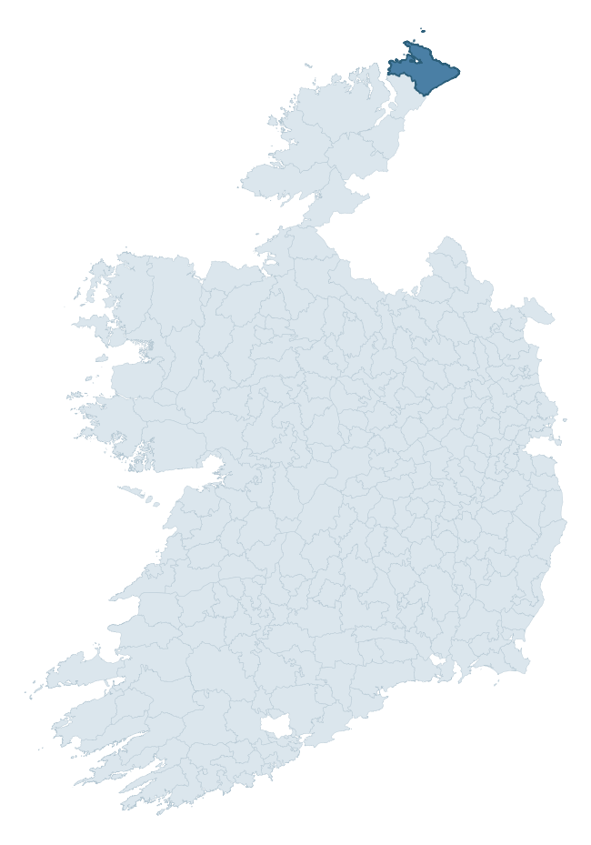
Where this barony sits in the Republic of Ireland
Geology and preservation
Bedrock geology shapes the landscape long before any settlement begins — controlling soil drainage, agricultural potential, the survival of upstanding monuments, and the preservation of buried archaeology. The figures below come from the Geological Survey Ireland 1:100,000 bedrock map.
The bedrock underlying Inishowen East is predominantly schist (41% of the barony by area), laid down during the Precambrian period (97% by area, over 540 million years ago). Schist forms upland, often steep terrain with thin soils that limited agriculture but favoured the construction of stone-built monuments and field walls. Schist landscapes commonly carry megalithic monuments and prehistoric ritual sites. A substantial secondary geology of grits (22%) and quartzite (14%) adds further variety to the underlying landscape. With 8 distinct rock types mapped, the barony sits in the top third of ROI baronies for geological diversity (80th percentile) — typically a sign of complex tectonic history or coastal mosaics of differing rock units.
Rock type composition
Largest mapped unit: Inishowen Head Grits and Phyllites Formation (22% of the barony)
Placename evidence
Logainm records 13 heritage-diagnostic placenames for Inishowen East, a modest sample drawn predominantly from the townland record. The dominant stratum is pre-christian defensive. The most frequent diagnostic roots are dún- (3) and caiseal- (2). With a sample of this size the count should be treated as indicative rather than definitive.
Pre-Christian / Early Medieval Defensive
| Root | Count | Meaning |
|---|---|---|
| dún- | 3 | hilltop or promontory fort |
| caiseal- | 2 | stone ringfort |
| ráth- | 1 | earthen ringfort |
Early Christian Ecclesiastical
| Root | Count | Meaning |
|---|---|---|
| cill- | 2 | church (early) |
| teampall- | 2 | church (later medieval) |
| domhnach- | 1 | pre-Patrician or earliest Patrician church |
Burial, Ritual, and Norse-Contact
| Root | Count | Meaning |
|---|---|---|
| carn- | 2 | cairn |
| gall- | 1 | foreigner — Norse settlement marker |
Other baronies in Donegal
About this profile
Click any section below to expand.
What is a barony?
A barony is a historic administrative unit in Ireland, broadly equivalent to an English hundred. The 280 baronies used here are from the OSi 2019 National Statutory Boundaries (generalised 20m), covering the 26 counties of the Republic of Ireland. Baronies derive from the Norman period, were formalised in the 17th century, and have not been redrawn for statistical purposes. They vary enormously in area, from compact urban baronies in Dublin to vast upland baronies in Connacht, and should not be compared by raw site count without accounting for area differences.
What counts as a site?
This profile combines three distinct heritage registers, each with its own definition of what constitutes a recordable site:
- Archaeological sites (NMS). The National Monuments Service Sites and Monuments Record (SMR) catalogues every known archaeological monument or site of archaeological interest in the Republic, from prehistoric burial mounds and ringforts to medieval churches and post-medieval defensive works. Inclusion does not require legal protection — only that the site has been identified, surveyed, and assessed as having archaeological value. A separate subset of these sites lies within a recorded protection zone, which gives them statutory protection under the National Monuments Acts.
- Listed buildings (NIAH). The National Inventory of Architectural Heritage records buildings of architectural, historical, archaeological, artistic, cultural, scientific, social, or technical interest. Each surveyed structure is appraised on a five-tier scale: International, National, Regional, Local, and Record-Only. The NIAH appraisal is informational rather than strictly statutory, but it underpins local-authority Record of Protected Structures (RPS) listings.
- Heritage placenames (Logainm). Logainm is the authoritative database of Irish placenames maintained by the Placenames Branch. This profile applies a heritage-diagnostic classifier to the Irish-language form of each townland name, flagging roots that signal defensive sites (ráth-, lios-, dún-, caiseal-, cathair-), ecclesiastical foundations (cill-, teampall-, domhnach-, mainistir-), prehistoric burial-ritual features (tuaim-, carn-, leaba-), or Norse-contact settlement (gall-). Townlands without one of these diagnostic roots are not flagged here — they may still carry historical significance, but that significance is not encoded in the name itself.
Editorial principles
The narrative sections of this profile follow several explicit principles:
- Evidential. Every claim about this barony’s heritage character is anchored in the underlying register data. Where a site count, a placename count, or a percentile rank is cited, it is computed from the source datasets at export time, not estimated.
- Comparative. Counts and metrics are reported alongside their percentile rank against the other 279 ROI baronies. A barony with 50 ringforts in absolute terms could be unusually high or unusually low depending on its size and regional context; percentile ranking removes that ambiguity.
- Transparent on limits. Where a register has known coverage gaps, survey biases, or data-quality issues that affect this barony’s figures, the profile flags them rather than presenting the numbers as definitive.
- No interpretation beyond what the data supports. The narrative does not speculate about historical events, social dynamics, or cultural meaning beyond what the recorded heritage and placename evidence directly attests.
Data caveats and limits
- NMS Sites and Monuments Record is the product of survey campaigns conducted at different intensities across different counties and decades. Some baronies have been surveyed more thoroughly than others, and absolute counts should be read in that light. Sites destroyed by development before survey are typically not represented; sites in heavily forested or upland terrain are sometimes under-recorded.
- NIAH coverage is broadly complete for the Republic of Ireland but the survey was conducted on a rolling county-by-county basis, and the most recent appraisal date varies. Buildings demolished or substantially altered after their original survey may still appear in the register; conversely, recent buildings of merit may not yet have been appraised.
- Logainm classification applies a deliberately conservative pattern-matching approach to the Irish-language townland forms. The classifier prioritises true positives over recall: a townland may carry a heritage signal that the classifier doesn’t recognise, particularly where the diagnostic root has been heavily anglicised or where the townland name draws on a less common term. The 60,000+ townland records and ~9,800 classified placenames give a substantial signal at barony scale, but individual townland names should be checked against Logainm directly for definitive interpretation.
- Period attribution. The chronological distribution reflects only those NMS sites that carry a recognised period attribution in the source data. Sites listed as “Unknown” period are excluded from the dated subset.
- Boundary changes. Some baronies have undergone minor boundary adjustments since their 19th-century definition; the OSi 2019 generalised boundaries used here are the current statutory definition and may differ slightly from historical maps in border areas.
- Bedrock geology is mapped at 1:100,000 scale, which means local variation within a barony — small pockets of different rock type, mineral veins, alluvium overlying bedrock — is generalised. The dominant-system and rocktype figures are area-weighted, so a barony reading “70% Carboniferous limestone” may still contain small but archaeologically important pockets of older or younger rock. Around 3% of GSI polygons do not match the lexicon and contribute no rocktype or system attribution.
Data sources
- National Monuments Service — Sites and Monuments Record (SMR) https://data.gov.ie/dataset/national-monuments-service-archaeological-survey-of-ireland
- National Inventory of Architectural Heritage (NIAH) https://data.gov.ie/dataset/national-inventory-of-architectural-heritage-niah-national-dataset
- Logainm — Placenames Database of Ireland https://www.logainm.ie/
- Ordnance Survey Ireland — National Statutory Barony Boundaries 2019 https://data-osi.opendata.arcgis.com/
- EURODEM — European Digital Elevation Model https://www.mapsforeurope.org/datasets/euro-dem
- ESA WorldCover https://esa-worldcover.org/en
- Geological Survey Ireland — 1:100,000 Bedrock Geology https://www.gsi.ie/en-ie/data-and-maps/Pages/Bedrock.aspx
Explore more: Search any of the 280 ROI baronies, browse by historical province, or read the methodology and data sources for the full Republic of Ireland Heritage Tool.