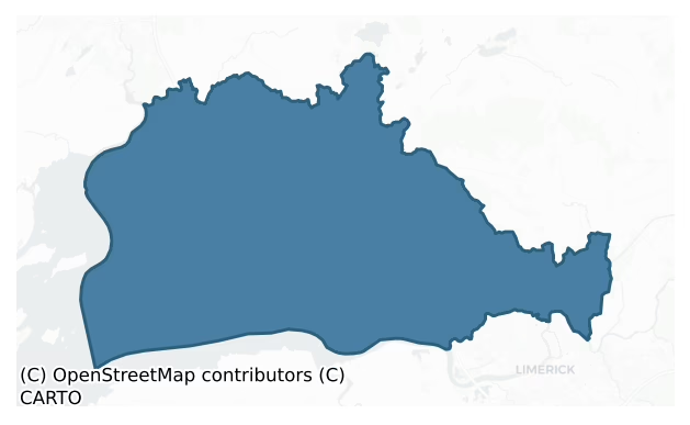
Bunratty Lower is a barony of County Clare, in the historical province of Munster (Irish: Bun Raite Íochtarach), covering 280 km² of land. The barony records 713 NMS archaeological sites and 33 NIAH listed buildings, placing it at around the 72nd percentile among 280 ROI baronies for sites per km². This means it is in the top third of all baronies for sites per km². Dated archaeological evidence runs from the Neolithic through to the Post Medieval, spanning 7 of 9 archaeological periods, placing the barony in the 31st percentile among 280 ROI baronies for chronological depth. This means it is in the bottom third of all baronies for chronological depth. The largest dated subset of recorded sites dates to the Iron Age. Logainm flags 41 placenames in the barony as carrying a recognised heritage root; the largest share — around 49% — are names associated with early Christian church and monastic foundations.
Heritage at a glance
Percentile rankings throughout this profile compare each barony only against the other 279 Republic of Ireland baronies.
The recorded heritage of Bunratty Lower
The National Monuments Service Sites and Monuments Record (SMR) is the statutory inventory of archaeological sites for the Republic of Ireland, maintained by the Department of Tourism, Culture, Arts, Gaeltacht, Sport and Media. Sites recorded here include earthworks, ringforts, megalithic tombs, ecclesiastical remains, and post-medieval features; not every record is legally protected, but each is registered as a monument of archaeological interest.
The National Monuments Service records 713 archaeological sites in Bunratty Lower, putting it at the 72nd percentile among 280 ROI baronies for sites per km². This means it is in the top third of all baronies for sites per km². Of these, 627 (88%) fall within a recorded monument protection zone. The dominant category is defensive sites — ringforts, enclosures, hillforts, and stone forts (365 sites, 51% of the record). The most diagnostically specific type is Ringfort – rath (55 records, 8% of the barony's NMS total) — compared to an ROI average of 20% across all baronies where this type occurs. Ringfort – rath is an earthen ringfort enclosed by a bank and external ditch — the most common Early Medieval farmstead, broadly dated 500–1000 AD. The broader 'Enclosure' classification — which catches unclassified ringforts and field enclosures — accounts for a further 164 records (23%) and reflects the difficulty of sub-classifying degraded earthworks from surface evidence alone. Across the barony's 280 km², this gives a recorded density of 2.55 sites per km².
Most common monument types
Hover or tap a monument type to see its definition.
| Type | Count |
|---|---|
| Enclosure a banked or ditched feature of uncertain type, used as a catch-all where the original function cannot be determined from surface evidence | 164 |
| Ringfort – rath an earthen ringfort enclosed by a bank and external ditch — the most common Early Medieval farmstead, broadly dated 500–1000 AD | 55 |
| Ringfort – unclassified a circular Early Medieval settlement enclosure where surviving evidence does not allow distinction between earthen and stone forms | 41 |
| Fulacht fia a horseshoe-shaped Bronze Age burnt mound built around a sunken trough beside a water source, traditionally interpreted as a cooking site | 38 |
| Ringfort – cashel the stone-walled equivalent of the rath, found mainly in upland or western areas, broadly dated 500–1000 AD | 35 |
| Standing stone a deliberately set upright stone, used variously as a Bronze/Iron Age burial marker, route marker or commemorative monument | 19 |
| Earthwork an unclassified earthen structure with no diagnostic features that allow a more specific classification | 17 |
Chronological distribution
The dated archaeological record for Bunratty Lower spans from the Neolithic through to the Post Medieval, with activity attested across 7 of 9 archaeological periods. Every period from earliest to latest is represented in the record — an unbroken sequence of dated activity across the full chronological span. Activity concentrates most heavily in the Iron Age (189 sites, 35% of dated material), with the Early Medieval forming a secondary peak (169 sites, 31%). A further 171 recorded sites (24% of the overall NMS register for the barony) carry no period attribution — appearing as 'Unknown' in the bar chart below. This typically reflects either records that pre-date the standardised period vocabulary or sites awaiting specialist dating review, rather than a genuine absence of chronological evidence.
Sample of recorded monuments
Show 25 sample monuments (of 713 total)
A representative sample of 25 recorded monuments drawn from the barony’s 713 total NMS entries. Sites within a recorded monument protection zone and rarer site types are prioritised so the list shows a meaningful cross-section rather than only the most common type. Each entry shows the official Sites and Monuments Record reference number and the description published by the National Monuments Service.
Gateway (present location)
A large stone gateway, formerly located in front of the 17th-century fortified house at Leamaneh North (CL016-032002-) possibly on the line of a wall defining a courtyard and moved to Dromoland gardens in 1907. The…
A large stone gateway, formerly located in front of the 17th-century fortified house at Leamaneh North (CL016-032002-) possibly on the line of a wall defining a courtyard and moved to Dromoland gardens in 1907. The gateway has a round arch with a stepped hood-moulding under which are two coats of arms. One is of Conor O'Brien, 1643, the other those of his son Sir Donat O'Brien about 1690. Under them in worn letters are the words 'This was built in the year of our Lord 1643 by Conor O'Brien and by Mary ni Mahon, wife of the said Connor.' (Westropp 1900, 404).
Compiled by: Mary Tunney
Date of upload: 14 November 2018
Cross-inscribed stone
The Archaeological Survey of Ireland (ASI) is in the process of providing information on all monuments on The Historic Environment Viewer (HEV). Currently the information for this record has not been uploaded. To…
The Archaeological Survey of Ireland (ASI) is in the process of providing information on all monuments on The Historic Environment Viewer (HEV). Currently the information for this record has not been uploaded. To access available information for research purposes please make an appointment in advance with the Archive Unit (open Fridays 10.00 am – 5.00 pm), Department of Culture, Heritage and the Gaeltacht, The Custom House, Dublin 1 D01W6XO or email nmarchive@chg.gov.ie.
Ecclesiastical enclosure
The Archaeological Survey of Ireland (ASI) is in the process of providing information on all monuments on The Historic Environment Viewer (HEV). Currently the information for this record has not been uploaded. To…
The Archaeological Survey of Ireland (ASI) is in the process of providing information on all monuments on The Historic Environment Viewer (HEV). Currently the information for this record has not been uploaded. To access available information for research purposes please make an appointment in advance with the Archive Unit (open Fridays 10.00 am – 5.00 pm), Department of Culture, Heritage and the Gaeltacht, The Custom House, Dublin 1 D01W6XO or email nmarchive@chg.gov.ie.
Enclosure – large enclosure
The Archaeological Survey of Ireland (ASI) is in the process of providing information on all monuments on The Historic Environment Viewer (HEV). Currently the information for this record has not been uploaded. To…
The Archaeological Survey of Ireland (ASI) is in the process of providing information on all monuments on The Historic Environment Viewer (HEV). Currently the information for this record has not been uploaded. To access available information for research purposes please make an appointment in advance with the Archive Unit (open Fridays 10.00 am – 5.00 pm), Department of Culture, Heritage and the Gaeltacht, The Custom House, Dublin 1 D01W6XO or email nmarchive@chg.gov.ie.
House – fortified house
See attached document with details from Risteárd Ua Cróinín and Martin Breen, The Castles and Tower-houses of Co. Clare (unpublished report). Uploaded courtesy of R. Ua Cróinín and M. Breen.
Date of upload: 18…
See attached document with details from Risteárd Ua Cróinín and Martin Breen, The Castles and Tower-houses of Co. Clare (unpublished report). Uploaded courtesy of R. Ua Cróinín and M. Breen.
Date of upload: 18 December 2014
Moated site
The Archaeological Survey of Ireland (ASI) is in the process of providing information on all monuments on The Historic Environment Viewer (HEV). Currently the information for this record has not been uploaded. To…
The Archaeological Survey of Ireland (ASI) is in the process of providing information on all monuments on The Historic Environment Viewer (HEV). Currently the information for this record has not been uploaded. To access available information for research purposes please make an appointment in advance with the Archive Unit (open Fridays 10.00 am – 5.00 pm), Department of Culture, Heritage and the Gaeltacht, The Custom House, Dublin 1 D01W6XO or email nmarchive@chg.gov.ie.
Megalithic tomb – unclassified
The Archaeological Survey of Ireland (ASI) is in the process of providing information on all monuments on The Historic Environment Viewer (HEV). Currently the information for this record has not been uploaded. To…
The Archaeological Survey of Ireland (ASI) is in the process of providing information on all monuments on The Historic Environment Viewer (HEV). Currently the information for this record has not been uploaded. To access available information for research purposes please make an appointment in advance with the Archive Unit (open Fridays 10.00 am – 5.00 pm), Department of Culture, Heritage and the Gaeltacht, The Custom House, Dublin 1 D01W6XO or email nmarchive@chg.gov.ie.
Mill – unclassified
The Archaeological Survey of Ireland (ASI) is in the process of providing information on all monuments on The Historic Environment Viewer (HEV). Currently the information for this record has not been uploaded. To…
The Archaeological Survey of Ireland (ASI) is in the process of providing information on all monuments on The Historic Environment Viewer (HEV). Currently the information for this record has not been uploaded. To access available information for research purposes please make an appointment in advance with the Archive Unit (open Fridays 10.00 am – 5.00 pm), Department of Culture, Heritage and the Gaeltacht, The Custom House, Dublin 1 D01W6XO or email nmarchive@chg.gov.ie.
Water mill – unclassified
The Archaeological Survey of Ireland (ASI) is in the process of providing information on all monuments on The Historic Environment Viewer (HEV). Currently the information for this record has not been uploaded. To…
The Archaeological Survey of Ireland (ASI) is in the process of providing information on all monuments on The Historic Environment Viewer (HEV). Currently the information for this record has not been uploaded. To access available information for research purposes please make an appointment in advance with the Archive Unit (open Fridays 10.00 am – 5.00 pm), Department of Culture, Heritage and the Gaeltacht, The Custom House, Dublin 1 D01W6XO or email nmarchive@chg.gov.ie.
Gallows
The Archaeological Survey of Ireland (ASI) is in the process of providing information on all monuments on The Historic Environment Viewer (HEV). Currently the information for this record has not been uploaded. To…
The Archaeological Survey of Ireland (ASI) is in the process of providing information on all monuments on The Historic Environment Viewer (HEV). Currently the information for this record has not been uploaded. To access available information for research purposes please make an appointment in advance with the Archive Unit (open Fridays 10.00 am – 5.00 pm), Department of Culture, Heritage and the Gaeltacht, The Custom House, Dublin 1 D01W6XO or email nmarchive@chg.gov.ie.
Castle – motte and bailey
See attached document with details from Risteárd Ua Cróinín and Martin Breen, The Castles and Tower-houses of Co. Clare (unpublished report). Uploaded courtesy of R. Ua Cróinín and M. Breen.
Date of upload: 19…
See attached document with details from Risteárd Ua Cróinín and Martin Breen, The Castles and Tower-houses of Co. Clare (unpublished report). Uploaded courtesy of R. Ua Cróinín and M. Breen.
Date of upload: 19 December 2014
Historic town
Situated on a low hill at ‘Bun Ráite’ (the mouth of the Ráite, now the Owenogarney River) in an area of considerable strategic importance since the Middle Ages as it controlled the passage of ships on the Shannon. The…
Situated on a low hill at ‘Bun Ráite’ (the mouth of the Ráite, now the Owenogarney River) in an area of considerable strategic importance since the Middle Ages as it controlled the passage of ships on the Shannon. The area, surrounded in the early 20th century by marshes to the S, W and N (Westropp 1917, 14-15), was at that time still isolated at high tide forming a naturally defensive location. According to Bradley et al. (1988, 19) the borough of Bunratty was situated in this area, most likely on the high ground to the N and W of the castle. The area is known as ‘Tradraighe’ or ‘Traderry’ and was first mentioned in the 12th century Cogadh Gaedhel re Gallaibh which states that c. 960 the Vikings of North Munster built a fort at ‘Tratraighe’ (Bradley 1988, 20). The precise location of this fort has not been determined. The Anglo-Norman settlement of Bunratty began in 1248 when Tradery was granted to Robert de Muscegros. A castle (see CL062-001004-) was under construction in 1251 and in 1253 de Muscegros was granted the right to have a vill, with a weekly market and yearly fair, in his land of ‘Bunraty’. The earliest evidence for a parish church occurs in 1256 when the priest Peter was appointed perpetual vicar. In 1277 the settlement passed to Thomas de Clare by which time it had acquired borough status. No charter survives but an extent of the manor of Bunratty from 1287 noted that the burgesses of the vill held 226 burgages, paying 131. 6s. annual rent. The extent also n…
Religious house – unclassified
The Archaeological Survey of Ireland (ASI) is in the process of providing information on all monuments on The Historic Environment Viewer (HEV). Currently the information for this record has not been uploaded. To…
The Archaeological Survey of Ireland (ASI) is in the process of providing information on all monuments on The Historic Environment Viewer (HEV). Currently the information for this record has not been uploaded. To access available information for research purposes please make an appointment in advance with the Archive Unit (open Fridays 10.00 am – 5.00 pm), Department of Culture, Heritage and the Gaeltacht, The Custom House, Dublin 1 D01W6XO or email nmarchive@chg.gov.ie.
Bridge
Situated 1.5km N of Limerick City over a stream flowing W to E into the River Shannon. A bridge built by the Mayor of Limerick in 1635. An inscribed limestone slab (1.21m x 0.61m) is built into the W parapet at ground…
Situated 1.5km N of Limerick City over a stream flowing W to E into the River Shannon. A bridge built by the Mayor of Limerick in 1635. An inscribed limestone slab (1.21m x 0.61m) is built into the W parapet at ground level. The inscription, in low relief, is in capital letters and reads, ‘HUNC PONTEM AC UIAM STRATAM FIERI FECIT PETRUS CREAGH FILIUS ANDREAE MAIOR CIVITATIS LIMERICENSIS SUMPTIBUS EIUSDEM CIVITATIS ANNO DNI 1635’ which translates ‘Peter Creagh, sone of Andrew [Creagh], Mayor of Limerick, had this bridge and street made at the expense of the city of Limerick, the year of the Lord 1635’. (Rynne 1977, 69-71 and Plate V)
Compiled by: Mary Tunney
Date of upload: 15 May 2017
Castle – ringwork
The Archaeological Survey of Ireland (ASI) is in the process of providing information on all monuments on The Historic Environment Viewer (HEV). Currently the information for this record has not been uploaded. To…
The Archaeological Survey of Ireland (ASI) is in the process of providing information on all monuments on The Historic Environment Viewer (HEV). Currently the information for this record has not been uploaded. To access available information for research purposes please make an appointment in advance with the Archive Unit (open Fridays 10.00 am – 5.00 pm), Department of Culture, Heritage and the Gaeltacht, The Custom House, Dublin 1 D01W6XO or email nmarchive@chg.gov.ie.
Hillfort
A trivallate hillfort, occupying the entire summit of a prominent limestone hill, c. 2.5km NE of Newmarket-on-Fergus, with commanding views over SE Clare, the Shannon Estuary to the S and the river Fergus to the W. It…
A trivallate hillfort, occupying the entire summit of a prominent limestone hill, c. 2.5km NE of Newmarket-on-Fergus, with commanding views over SE Clare, the Shannon Estuary to the S and the river Fergus to the W. It has three roughly concentric ramparts comprising massive walls of uncoursed stone. The outer rampart encloses an area of about 11 hectares and the ramparts have a total length of 2.1km. Each rampart is set along the outer edge of a natural step in the limestone thereby enhancing the apparent height. It is believed that the ramparts were built as a single enterprise over a period of about a decade and the radiocarbon evidence as a whole suggests that this would have occurred in the final two decades of the tenth century BC. Survey and excavation (licence no. 92E0093) by the Discovery Programme, as part of the North Munster Project, took place in 1992-4.
The inner rampart (av. H 1.5m; Wth 6-9m) encloses an area of 0.75 hectares (diam. 110m E-W; 90m N-S). Variations in slope and topography account for some differences in construction and the building of a later cashel (CL042-074002-) on top of the middle rampart caused considerable destruction at SW. While Westropp (1908-9) indicated three gaps in this rampart, these represent modern access points. A previously unrecorded gap (av. Wth 0.9m) at SE faced with slabs and upright blocks was identified during pre-excavation clearance. The track leading to this had to meander around the hill following a circuit betwe…
Kiln – lime
The Archaeological Survey of Ireland (ASI) is in the process of providing information on all monuments on The Historic Environment Viewer (HEV). Currently the information for this record has not been uploaded. To…
The Archaeological Survey of Ireland (ASI) is in the process of providing information on all monuments on The Historic Environment Viewer (HEV). Currently the information for this record has not been uploaded. To access available information for research purposes please make an appointment in advance with the Archive Unit (open Fridays 10.00 am – 5.00 pm), Department of Culture, Heritage and the Gaeltacht, The Custom House, Dublin 1 D01W6XO or email nmarchive@chg.gov.ie.
Mass-rock
The Archaeological Survey of Ireland (ASI) is in the process of providing information on all monuments on The Historic Environment Viewer (HEV). Currently the information for this record has not been uploaded. To…
The Archaeological Survey of Ireland (ASI) is in the process of providing information on all monuments on The Historic Environment Viewer (HEV). Currently the information for this record has not been uploaded. To access available information for research purposes please make an appointment in advance with the Archive Unit (open Fridays 10.00 am – 5.00 pm), Department of Culture, Heritage and the Gaeltacht, The Custom House, Dublin 1 D01W6XO or email nmarchive@chg.gov.ie.
Town defences
The 14th century Caithréim Thoirdhealbhaigh refers to the borough of Bunratty being defended by ‘broad-based high-crested ramparts, running from the stream to the sea’ (Bradley 1988, 22). Monitoring of foundation…
The 14th century Caithréim Thoirdhealbhaigh refers to the borough of Bunratty being defended by ‘broad-based high-crested ramparts, running from the stream to the sea’ (Bradley 1988, 22). Monitoring of foundation trenches for an extension to the Shannon Shamrock Hotel in 1991 (O’Rahilly 1992) showed evidence for a ditch (Wth 8.5m) extending E-W, filled and recut with finds dating it to the 13th/14th century. Test trenching (Wiggins 2000) in advance of a development of houses in the area revealed a substantial ditch (Wth greater than 8m, aligned E-W), likely part of the same ditch found by Celie O’Rahilly in 1991. Given its dimensions, the ditch must be considered part of the defences of the medieval borough of Bunratty (Wiggins 2000, 7-8). Some outer earthworks around Bunratty, planned by Westropp (1917, opp. p. 14) and traditionally interpreted as fortified ramparts for either 10th-century Viking or 13th-century Anglo-Norman settlements, have been shown to be 17th century in date (Bradley and King 1991). Historical and cartographic sources indicate that reclamation banks were in place by the mid-seventeenth century, built to protect the low-lying lands around Bunratty from high spring tide flooding (O’Sullivan (2001, 52).
Compiled by: Mary Tunney
Date of upload: 2 October 2019
Dovecote
Situated c. 60m SW of the 17th-century church within the historic town of Bunratty. According to Westropp (1915, 316) ‘beyond the church is the massive buttressed pier of the ancient pigeon house’. In 1917 (opp. p. 14)…
Situated c. 60m SW of the 17th-century church within the historic town of Bunratty. According to Westropp (1915, 316) ‘beyond the church is the massive buttressed pier of the ancient pigeon house’. In 1917 (opp. p. 14) Westropp indicates and names a pigeon house on his plan of Bunratty. The surviving portion is very ruined and overgrown. It comprises a straight stretch of roughly coursed limestone rubble extending S-N for 2.1m, angling at 45 degrees to E for 1.5m and continuing W-E for 1.17m (max. H 3m). It is not possible to make out definite niches on the interior.
The following image has been uploaded:
CL061-011004-_01.jpg View of remaining portion of dovecote from N.
Compiled by: Mary Tunney
Date of upload: 2 October 2019.
Castle – hall-house
Within the historic town of Bunratty (CL061-011—-/CL062-001000*), the castle is situated on low ground immediately W of the Owenogarney River. Four castles are recorded at Bunratty, beginning in 1251 when the…
Within the historic town of Bunratty (CL061-011—-/CL062-001000*), the castle is situated on low ground immediately W of the Owenogarney River. Four castles are recorded at Bunratty, beginning in 1251 when the Anglo-Norman Robert de Muscegros erected a fortification, having been granted the area known as ‘Tradraighe’ in 1248 (Bradley 1988, 20). This may have been an earthen and wooden construction as there is reference to it acquiring a palisade of oaks in 1252 (Bradley et al. 1988, 22). The precise location of this fortification is unknown. In 1277 the settlement at Bunratty passed to Thomas de Clare who built the first stone castle (ibid., 23). This withstood attacks by the Irish in the 1290s but was burnt by 1306 and, according to the sources, finally destroyed in 1332 (Bradley 1988, 24). In 1353 the castle was refortified by Thomas de Rokeby but after only two years it was captured and again destroyed (Salter 2004, 22). The destruction appears to have been exaggerated as there is physical evidence, discussed below, of the 14th-century castle, probably a form of hall-house, surviving within the fabric of the present castle.
The castle, in its current manifestation, is attributed to Maccon MacNamara (Bradley et al. 1988, 25), and was constructed in the 15th century, incorporating the remains of the earlier structure. It passed into the hands of the O’Briens around 1500 (ibid, 25). Between 1583 and 1588 Donough O’Brien, the ‘Great Earl’, made Bunratty his headquart…
Battery
Situated on high ground to the NW of Bunratty Castle (CL062-001004-) this consists of a rectangular mound measuring c. 23m E-W by 30m N-S at the base and 11.7m E-W by 18m N-S on the top (Bradley et al. 1988, 21).…
Situated on high ground to the NW of Bunratty Castle (CL062-001004-) this consists of a rectangular mound measuring c. 23m E-W by 30m N-S at the base and 11.7m E-W by 18m N-S on the top (Bradley et al. 1988, 21). Westropp (1915, 315) suggested that this may have been the original motte castle and recorded a fosse and outer mound or ‘bailey’. The fosse has been removed by landscaping and the sub-rectangular lawn, south of the mound, which is raised about 1-3m above surrounding ground level may be identified with Westropp’s ‘bailey’ (Bradley et al. 1988, ). The mound was partially excavated by John Hunt in 1959 (Hunt 1959) who also discovered the lower courses of a possible 16th century house (CL062-001008-) beside it. He considered that the mound was not the original Anglo-Norman motte but a gun emplacement erected for four cannon mentioned by Admiral Penn in his account of the defense of the castle (O’Brien 1990): this position would have defended the broad deep channel of water then separating the castle from the high ground to the N. He further suggested that ‘some sort of 'Herd' or fence of stout logs or perhaps gabions of basketwork and earth would presumably have been erected on the top edge of the mound to protect the guns and gunners from musket and cannon shot. The subsequent burning of this, after the capture of the castle by the Confederates, would account for the burned material in its present position in the fosse.’ (Hunt 1959, 89). The precise location of the…
Structure
The Archaeological Survey of Ireland (ASI) is in the process of providing information on all monuments on The Historic Environment Viewer (HEV). Currently the information for this record has not been uploaded. To…
The Archaeological Survey of Ireland (ASI) is in the process of providing information on all monuments on The Historic Environment Viewer (HEV). Currently the information for this record has not been uploaded. To access available information for research purposes please make an appointment in advance with the Archive Unit (open Fridays 10.00 am – 5.00 pm), Department of Culture, Heritage and the Gaeltacht, The Custom House, Dublin 1 D01W6XO or email nmarchive@chg.gov.ie.
Flat cemetery
The Archaeological Survey of Ireland (ASI) is in the process of providing information on all monuments on The Historic Environment Viewer (HEV). Currently the information for this record has not been uploaded. To…
The Archaeological Survey of Ireland (ASI) is in the process of providing information on all monuments on The Historic Environment Viewer (HEV). Currently the information for this record has not been uploaded. To access available information for research purposes please make an appointment in advance with the Archive Unit (open Fridays 10.00 am – 5.00 pm), Department of Culture, Heritage and the Gaeltacht, The Custom House, Dublin 1 D01W6XO or email nmarchive@chg.gov.ie.
Enclosure
The Archaeological Survey of Ireland (ASI) is in the process of providing information on all monuments on The Historic Environment Viewer (HEV). Currently the information for this record has not been uploaded. To…
The Archaeological Survey of Ireland (ASI) is in the process of providing information on all monuments on The Historic Environment Viewer (HEV). Currently the information for this record has not been uploaded. To access available information for research purposes please make an appointment in advance with the Archive Unit (open Fridays 10.00 am – 5.00 pm), Department of Culture, Heritage and the Gaeltacht, The Custom House, Dublin 1 D01W6XO or email nmarchive@chg.gov.ie.
Listed buildings
The National Inventory of Architectural Heritage (NIAH) is a state survey appraising buildings of architectural, historical, archaeological, artistic, cultural, scientific, social, or technical interest. Each surveyed structure receives a rating from International (the highest, for buildings of European importance) through National, Regional, Local, and Record-Only.
The NIAH records only 33 listed buildings in Bunratty Lower, the 15th percentile across ROI baronies — a relatively thin architectural record. Among these, 6 are graded National — buildings of interest to the whole of Ireland rather than only its region. The Republic holds 937 National-graded buildings in total, so this barony accounts for around 1% of the national total. Construction dates concentrate most heavily in the Late Georgian (1800-1830) period. The most-recorded building type is house (12 examples, 36% of the listed stock).
Terrain and environment
Mean elevation across the barony is 34m — the 8th percentile among 280 ROI baronies for elevation. This means it is in the bottom tenth of all baronies for elevation. This is a relatively low-lying landscape by ROI standards. Elevation matters for heritage because higher-altitude baronies typically favour defensive monuments — ringforts and hilltop forts placed on prominent ground — while lowland baronies are more likely to carry the dense settlement and church networks of intensive agricultural landscapes. The barony reaches 307m at its highest point — a vertical span of more than 273m within its boundary, indicating significant topographic diversity. Mean slope is 3.2° — the 41st percentile among 280 ROI baronies for slope. This means it is in the lower half of all baronies for slope. Slope is a key control on both land use and archaeological preservation: steep ground resists ploughing and tends to preserve earthworks intact, while gentle slopes favour intensive cultivation that damages or destroys surface archaeology over time. The Topographic Wetness Index averages 11.3, the 68th percentile among 280 ROI baronies for wetness. This means it is in the top third of all baronies for wetness. Drainage matters for heritage because poorly-drained ground preserves organic archaeology (wooden trackways, leather, textiles, and on rare occasions human remains) far better than free-draining soil; well-drained ground favours arable use but destroys organic material rapidly. The land-cover mosaic combines improved grassland (61%), woodland (19%), and open water (16%), giving a mixed agricultural and semi-natural landscape.
Terrain measurements
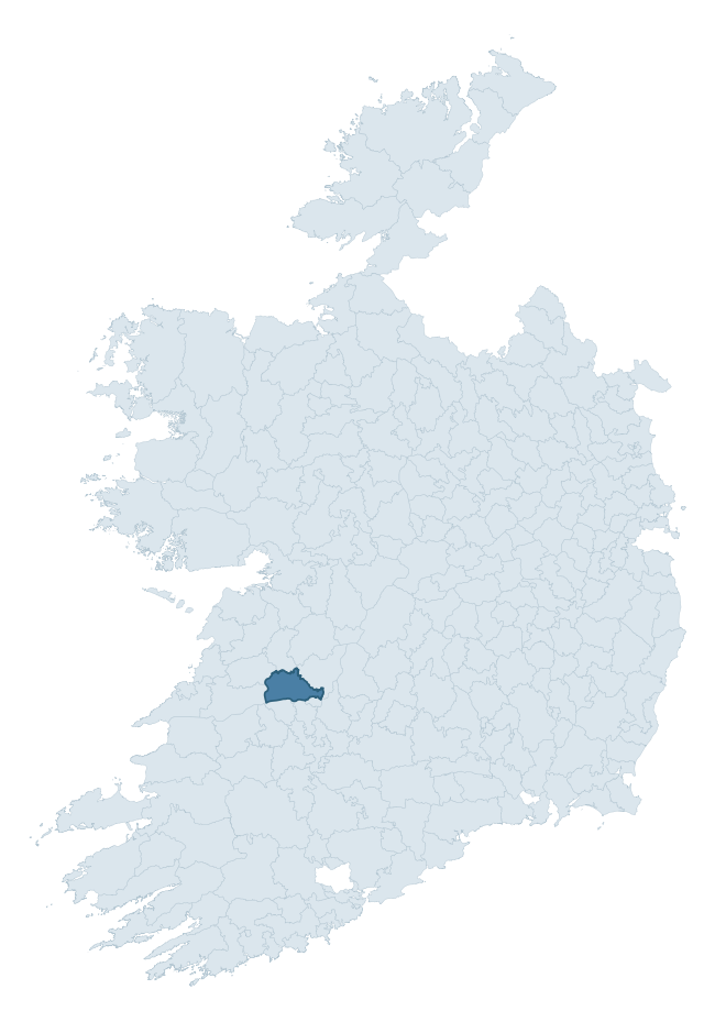
Where this barony sits in the Republic of Ireland
Geology and preservation
Bedrock geology shapes the landscape long before any settlement begins — controlling soil drainage, agricultural potential, the survival of upstanding monuments, and the preservation of buried archaeology. The figures below come from the Geological Survey Ireland 1:100,000 bedrock map.
The bedrock underlying Bunratty Lower is predominantly limestone (62% of the barony by area), laid down during the Carboniferous period (80% by area, around 359 to 299 million years ago). Limestone is the most heritage-rich bedrock in Ireland. It supports fertile, well-drained soils that favoured dense Early Medieval settlement and Norman manorial agriculture, and it weathers into karst features — sinkholes, caves, swallow holes, and souterrains — that frequently carry archaeology. Where peat overlies limestone, organic preservation can be exceptional. A substantial secondary geology of red clastics (17%) and limestones (12%) adds further variety to the underlying landscape. The single largest mapped unit is the Ballysteen Formation (25% of the barony's bedrock).
Rock type composition
Largest mapped unit: Ballysteen Formation (25% of the barony)
Placename evidence
Logainm records 41 heritage-diagnostic placenames for Bunratty Lower, drawn from townland and civil-parish names across the barony. The dominant stratum is Early Christian ecclesiastical — cill-, teampall-, and domhnach-prefixed names that record the dense network of early church foundations established between the fifth and tenth centuries. The leading diagnostic roots are cill- (18 — church), ráth- (5 — earthen ringfort), and lios- (4 — ringfort or enclosure). This is above the ROI average of 30.7 heritage placenames per barony. The presence of multiple heritage strata side by side indicates layered occupation of the landscape across successive prehistoric and historic periods. Logainm records 252 placenames for Bunratty Lower (predominantly townland names). Of these, 41 (16%) carry one of the diagnostic Gaelic roots tracked above; the remainder draw on more generic landscape vocabulary that does not encode a heritage period.
Pre-Christian / Early Medieval Defensive
| Root | Count | Meaning |
|---|---|---|
| ráth- | 5 | earthen ringfort |
| lios- | 4 | ringfort or enclosure |
| cathair- | 4 | stone fort |
| caiseal- | 2 | stone ringfort |
| dún- | 1 | hilltop or promontory fort |
Early Christian Ecclesiastical
| Root | Count | Meaning |
|---|---|---|
| cill- | 18 | church (early) |
| domhnach- | 1 | pre-Patrician or earliest Patrician church |
| cillín- | 1 | unconsecrated burial ground |
Burial, Ritual, and Norse-Contact
| Root | Count | Meaning |
|---|---|---|
| tuaim- | 2 | burial mound |
| gall- | 2 | foreigner — Norse settlement marker |
| leacht- | 1 | grave monument |
Other baronies in Clare
- Tulla Lower
- Islands
- Clonderalaw
- Leitrim
- Tulla Upper
- Inchiquin
- Bunratty Upper
- Coshmore And Coshbride — Waterford
- Burren
- Moyarta
See all 280 baronies in the Republic of Ireland Heritage Tool.

Explore further
Grounding History: 10 Maps of Northern Ireland’s Past
If you’re interested in Irish heritage more widely, the companion report for Northern Ireland brings together the analysis of all 462 NI wards into one place through 10 high-quality maps — covering monument density, archaeological periods, placename heritage, terrain, wetland, and the historic landscape at first survey. Take a look.
About this profile
Click any section below to expand.
What is a barony?
A barony is a historic administrative unit in Ireland, broadly equivalent to an English hundred. The 280 baronies used here are from the OSi 2019 National Statutory Boundaries (generalised 20m), covering the 26 counties of the Republic of Ireland. Baronies derive from the Norman period, were formalised in the 17th century, and have not been redrawn for statistical purposes. They vary enormously in area, from compact urban baronies in Dublin to vast upland baronies in Connacht, and should not be compared by raw site count without accounting for area differences.
What counts as a site?
This profile combines three distinct heritage registers, each with its own definition of what constitutes a recordable site:
- Archaeological sites (NMS). The National Monuments Service Sites and Monuments Record (SMR) catalogues every known archaeological monument or site of archaeological interest in the Republic, from prehistoric burial mounds and ringforts to medieval churches and post-medieval defensive works. Inclusion does not require legal protection — only that the site has been identified, surveyed, and assessed as having archaeological value. A separate subset of these sites lies within a recorded protection zone, which gives them statutory protection under the National Monuments Acts.
- Listed buildings (NIAH). The National Inventory of Architectural Heritage records buildings of architectural, historical, archaeological, artistic, cultural, scientific, social, or technical interest. Each surveyed structure is appraised on a five-tier scale: International, National, Regional, Local, and Record-Only. The NIAH appraisal is informational rather than strictly statutory, but it underpins local-authority Record of Protected Structures (RPS) listings.
- Heritage placenames (Logainm). Logainm is the authoritative database of Irish placenames maintained by the Placenames Branch. This profile applies a heritage-diagnostic classifier to the Irish-language form of each townland name, flagging roots that signal defensive sites (ráth-, lios-, dún-, caiseal-, cathair-), ecclesiastical foundations (cill-, teampall-, domhnach-, mainistir-), prehistoric burial-ritual features (tuaim-, carn-, leaba-), or Norse-contact settlement (gall-). Townlands without one of these diagnostic roots are not flagged here — they may still carry historical significance, but that significance is not encoded in the name itself.
Editorial principles
The narrative sections of this profile follow several explicit principles:
- Evidential. Every claim about this barony’s heritage character is anchored in the underlying register data. Where a site count, a placename count, or a percentile rank is cited, it is computed from the source datasets at export time, not estimated.
- Comparative. Counts and metrics are reported alongside their percentile rank against the other 279 ROI baronies. A barony with 50 ringforts in absolute terms could be unusually high or unusually low depending on its size and regional context; percentile ranking removes that ambiguity.
- Transparent on limits. Where a register has known coverage gaps, survey biases, or data-quality issues that affect this barony’s figures, the profile flags them rather than presenting the numbers as definitive.
- No interpretation beyond what the data supports. The narrative does not speculate about historical events, social dynamics, or cultural meaning beyond what the recorded heritage and placename evidence directly attests.
Data caveats and limits
- NMS Sites and Monuments Record is the product of survey campaigns conducted at different intensities across different counties and decades. Some baronies have been surveyed more thoroughly than others, and absolute counts should be read in that light. Sites destroyed by development before survey are typically not represented; sites in heavily forested or upland terrain are sometimes under-recorded.
- NIAH coverage is broadly complete for the Republic of Ireland but the survey was conducted on a rolling county-by-county basis, and the most recent appraisal date varies. Buildings demolished or substantially altered after their original survey may still appear in the register; conversely, recent buildings of merit may not yet have been appraised.
- Logainm classification applies a deliberately conservative pattern-matching approach to the Irish-language townland forms. The classifier prioritises true positives over recall: a townland may carry a heritage signal that the classifier doesn’t recognise, particularly where the diagnostic root has been heavily anglicised or where the townland name draws on a less common term. The 60,000+ townland records and ~9,800 classified placenames give a substantial signal at barony scale, but individual townland names should be checked against Logainm directly for definitive interpretation.
- Period attribution. The chronological distribution reflects only those NMS sites that carry a recognised period attribution in the source data. Sites listed as “Unknown” period are excluded from the dated subset.
- Boundary changes. Some baronies have undergone minor boundary adjustments since their 19th-century definition; the OSi 2019 generalised boundaries used here are the current statutory definition and may differ slightly from historical maps in border areas.
- Bedrock geology is mapped at 1:100,000 scale, which means local variation within a barony — small pockets of different rock type, mineral veins, alluvium overlying bedrock — is generalised. The dominant-system and rocktype figures are area-weighted, so a barony reading “70% Carboniferous limestone” may still contain small but archaeologically important pockets of older or younger rock. Around 3% of GSI polygons do not match the lexicon and contribute no rocktype or system attribution.
Data sources
- National Monuments Service — Sites and Monuments Record (SMR) https://data.gov.ie/dataset/national-monuments-service-archaeological-survey-of-ireland
- National Inventory of Architectural Heritage (NIAH) https://data.gov.ie/dataset/national-inventory-of-architectural-heritage-niah-national-dataset
- Logainm — Placenames Database of Ireland https://www.logainm.ie/
- Ordnance Survey Ireland — National Statutory Barony Boundaries 2019 https://data-osi.opendata.arcgis.com/
- EURODEM — European Digital Elevation Model https://www.mapsforeurope.org/datasets/euro-dem
- ESA WorldCover https://esa-worldcover.org/en
- Geological Survey Ireland — 1:100,000 Bedrock Geology https://www.gsi.ie/en-ie/data-and-maps/Pages/Bedrock.aspx
Explore more: Search any of the 280 ROI baronies, browse by historical province, or read the methodology and data sources for the full Republic of Ireland Heritage Tool.