
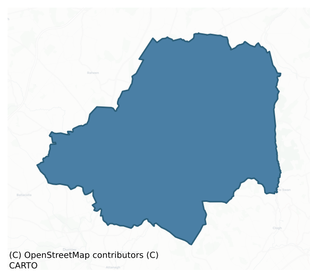
Cullenagh is a barony of County Laois, in the historical province of Leinster (Irish: Cuileannach), covering 178 km² of land. The barony records 179 NMS archaeological sites and 89 NIAH listed buildings, placing it at around the 13th percentile among 280 ROI baronies for sites per km². This means it is in the bottom fifth of all baronies for sites per km². Dated archaeological evidence runs from the Neolithic through to the Post Medieval, spanning 6 of 9 archaeological periods, placing the barony in the 19th percentile among 280 ROI baronies for chronological depth. This means it is in the bottom fifth of all baronies for chronological depth. The largest dated subset of recorded sites dates to the Iron Age. Logainm flags 15 placenames in the barony as carrying a recognised heritage root; the largest share — around 53% — are names associated with early Christian church and monastic foundations.
Heritage at a glance
Percentile rankings throughout this profile compare each barony only against the other 279 Republic of Ireland baronies.
The recorded heritage of Cullenagh
The National Monuments Service Sites and Monuments Record (SMR) is the statutory inventory of archaeological sites for the Republic of Ireland, maintained by the Department of Tourism, Culture, Arts, Gaeltacht, Sport and Media. Sites recorded here include earthworks, ringforts, megalithic tombs, ecclesiastical remains, and post-medieval features; not every record is legally protected, but each is registered as a monument of archaeological interest.
The National Monuments Service records 179 archaeological sites in Cullenagh, putting it at the 13th percentile among 280 ROI baronies for sites per km². This means it is in the bottom fifth of all baronies for sites per km². A sparse recorded total of this kind in Ireland often reflects survey priority rather than genuine absence of past activity. Protection coverage is near-universal — 172 sites (96%) fall within a recorded monument protection zone, indicating an extensively surveyed landscape. The dominant category is defensive sites — ringforts, enclosures, hillforts, and stone forts (99 sites, 55% of the record). The most diagnostically specific type is Ringfort – rath (20 records, 11% of the barony's NMS total) — compared to an ROI average of 20% across all baronies where this type occurs. Ringfort – rath is an earthen ringfort enclosed by a bank and external ditch — the most common Early Medieval farmstead, broadly dated 500–1000 AD. The broader 'Enclosure' classification — which catches unclassified ringforts and field enclosures — accounts for a further 50 records (28%) and reflects the difficulty of sub-classifying degraded earthworks from surface evidence alone. Across the barony's 178 km², this gives a recorded density of 1.00 sites per km².
Most common monument types
Hover or tap a monument type to see its definition.
| Type | Count |
|---|---|
| Enclosure a banked or ditched feature of uncertain type, used as a catch-all where the original function cannot be determined from surface evidence | 50 |
| Ringfort – rath an earthen ringfort enclosed by a bank and external ditch — the most common Early Medieval farmstead, broadly dated 500–1000 AD | 20 |
| Church a building used for public Christian worship, of any date from c. 500 AD onwards | 13 |
| Moated site | 13 |
| Graveyard a burial area associated with a church, in use from the medieval period onwards | 12 |
| Burial an isolated interment of human or animal remains, not associated with a formal burial ground | 5 |
| Castle – unclassified a castle whose form cannot be precisely classified, dating somewhere between the late 12th and 16th centuries | 3 |
| Standing stone a deliberately set upright stone, used variously as a Bronze/Iron Age burial marker, route marker or commemorative monument | 3 |
Chronological distribution
The dated archaeological record for Cullenagh spans from the Neolithic through to the Post Medieval, with activity attested across 6 of 9 archaeological periods. This is the 19th percentile across ROI baronies — a relatively narrow chronological band, with much of Irish prehistory not represented in the dated record. The record is near-continuous, with only the Middle Late Bronze Age period falling inside the span without any recorded sites. Activity concentrates most heavily in the Iron Age (69 sites, 54% of dated material), with the Early Medieval forming a secondary peak (31 sites, 24%). A further 51 recorded sites (28% of the overall NMS register for the barony) carry no period attribution — appearing as 'Unknown' in the bar chart below. This typically reflects either records that pre-date the standardised period vocabulary or sites awaiting specialist dating review, rather than a genuine absence of chronological evidence.
Sample of recorded monuments
Show 25 sample monuments (of 179 total)
A representative sample of 25 recorded monuments drawn from the barony’s 179 total NMS entries. Sites within a recorded monument protection zone and rarer site types are prioritised so the list shows a meaningful cross-section rather than only the most common type. Each entry shows the official Sites and Monuments Record reference number and the description published by the National Monuments Service.
Water mill – horizontal-wheeled
Reference to a horizontal watermill (NMI files). No visible remains.
The above description is derived from the published 'Archaeological Inventory of County Laois' (Dublin Stationery Office, 1995) compiled by P.…
Reference to a horizontal watermill (NMI files). No visible remains.
The above description is derived from the published 'Archaeological Inventory of County Laois' (Dublin Stationery Office, 1995) compiled by P. David Sweetman, Olive Alcock and Bernie Moran. In certain instances the entries have been revised and updated in the light of recent research.
Date of upload: 17 December 2007
Ecclesiastical enclosure
Reference to an enclosure here (O'Hanlon and O'Leary 1907, vol. 1, 188, 189). No visible surface remains. Described in the History of Queens County as 'The graveyard of Kilvahan occupies an elevated situation and its…
Reference to an enclosure here (O'Hanlon and O'Leary 1907, vol. 1, 188, 189). No visible surface remains. Described in the History of Queens County as 'The graveyard of Kilvahan occupies an elevated situation and its surrounded by a nearly circular fosse, which was formerly entered by an old road leading from the adjoining village of Moneeenafullagh, the little marshy spot of blood' on the direction from Ballyknockan Castle. The passage of funeral processions to the cemetery (LA018-017002-), at present, leads along a headland of the adjacent field to the boreen, where traces of the old road (LA018-017004-) are to be seen. Of late a wall of enclosure has been built around the cemetery by the Poor Law Guardians. Formerly and indeed to the beginning of the present century, an old ruined church (LA018-017001-) was to be seen within the burial enclosure of Kilvahan. From a perfect local knowledge of the spot, the writer has not been able to trace a single vetsige of those ancient walls' (O'Hanlon and O'Leary 1907, vol. 1, 189).
The above description is derived from the published 'Archaeological Inventory of County Laois' (Dublin Stationery Office, 1995) compiled by P. David Sweetman, Olive Alcock and Bernie Moran. In certain instances the entries have been revised and updated in the light of recent research.
Date of upload: 17 December 2007
Tomb – unclassified
Not marked on the 1841 or 1909 eds OS 6-inch maps. Burial place of the Moores of Cremorgan (Comerford 1886, vol. 3, 375). Visible are four O'More tombstones post 1700 AD in date.
The above description is derived from…
Not marked on the 1841 or 1909 eds OS 6-inch maps. Burial place of the Moores of Cremorgan (Comerford 1886, vol. 3, 375). Visible are four O'More tombstones post 1700 AD in date.
The above description is derived from the published 'Archaeological Inventory of County Laois' (Dublin Stationery Office, 1995) compiled by P. David Sweetman, Olive Alcock and Bernie Moran. In certain instances the entries have been revised and updated in the light of recent research.
Date of upload: 17 December 2007
Road – road/trackway
Not marked on the 1838 or 1909 eds OS 6-inch maps. In undulating countryside. Reference to a road in this area (Feehan 1983, 457). No visible surface remains.
The above description is derived from the published…
Not marked on the 1838 or 1909 eds OS 6-inch maps. In undulating countryside. Reference to a road in this area (Feehan 1983, 457). No visible surface remains.
The above description is derived from the published 'Archaeological Inventory of County Laois' (Dublin Stationery Office, 1995) compiled by P. David Sweetman, Olive Alcock and Bernie Moran. In certain instances the entries have been revised and updated in the light of recent research.
Date of upload: 17 December 2007
Ecclesiastical site
St. Mochua, who died c. 657 founded an Early Christian monastery at Timahoe (Teach Mochua). The saint's feastday is commemorated on the 24th of December (Ó Riain 2011, 469). It was plundered and burnt in 919 and 1142…
St. Mochua, who died c. 657 founded an Early Christian monastery at Timahoe (Teach Mochua). The saint's feastday is commemorated on the 24th of December (Ó Riain 2011, 469). It was plundered and burnt in 919 and 1142 (Gwynn and Hadcock 1970, 45). In later medieval times, the O'Mores refounded the monastery, and in 1609 it was granted to Richard Cosby. The round tower (LA018-031005-) is the only surviving feature of the early foundation. It probably dates to the twelfth century, though its base may be earlier. Built of sandstone and limestone, it is six storeys high (H 29.6m) and is roofed with a conical cap (Barrow 1979, 135-9). No floors survive. It is renowned for its Romanesque doorway, visible at first floor level, which has four receding orders, in two pairs, and is finely decorated with human heads with intertwined hair. A window decorated in a similar style is visible at second floor level. Slit, square-headed and pointed windows are on the other floors.
The fifteenth century church, to SE of tower, was transformed in the sixteenth century into a tower house (LA018-031006-) (Harbison 1970, 141), probably by one of the Cosbys. The only surviving feature of this church is a large arch (Wth 3.95m), possibly the chancel arch, which was blocked up and incorporated into the E wall of the castle. It is composed of punch-dressed chamfered limestone with evidence of diagonal tooling (Petrie 1845, 234-43; Crawford 1924, 31-42).
The above description is derived from the…
Round tower
National Monument No. 114. Built with sandstone and limestone blocks standing 96 feet [29m] high (Crawford 1924, 31-45). Circumference at base of main body c. 17.5m, circumference of foundation level c. 20.75m. It…
National Monument No. 114. Built with sandstone and limestone blocks standing 96 feet [29m] high (Crawford 1924, 31-45). Circumference at base of main body c. 17.5m, circumference of foundation level c. 20.75m. It contains a Romanesque doorway with four orders of sandstone blocks at first floor level in the E face. At the W is a single stone round-arch window, at the S is a pointed arched window of four stones and at the top of the tower is a two stone pointed arch window at each point of the compass. The tower is six storeys high each wooden floor being carried on an offset. The two first floors were not lighted by any windows, the third storey was lit by a doorway on the E face which was approx. 15 ft. above the level of the ground. The fourth floor was lit by a pointed window in the S face, small square window in the N face at fifth floor level, and the sixth floor was lit by a square window on the W face. Four triangular headed windows facing the four cardinal points are situated on the top floor immediately beneath the conical cap. The internal arch of the doorway is decorated with lozenge patterns or chevrons while the doorway is decorated with typical Romanesque features such as human faces on the angles of the capitals.
The round tower (LA018-031005-) is the only surviving feature of the early foundation. It probably dates to the twelfth century, though its base may be earlier. Built of sandstone and limestone, it is six storeys high (H 29.6m) and is roofed with…
Sheela-na-gig
Reference to a strange figure in stone at the doorway of Timahoe tower house (LA018-031006-) and a grotesque stone figure (Anon 1894, 80, 393). Not clear whether this is referring to the same or a second figure.…
Reference to a strange figure in stone at the doorway of Timahoe tower house (LA018-031006-) and a grotesque stone figure (Anon 1894, 80, 393). Not clear whether this is referring to the same or a second figure. According to local information, there was a figure on the part of the N wall which has fallen; it may be buried beneath debris (Guest 1936, 114). No visible surface remains. In 1894 it was recorded that at Timahoe there was ‘a grotesque figure requiring further inquiry’ (Anon 1894, 393). In the same year it was recorded that at Timahoe Castle (LA018-031006-) there was ‘a strange figure in stone, at the doorway of this castle. Its claim to admission in the list is open to doubt; but it is figured in a series of drawings belonging to the late Thomas Cooke, Esq., of Parsonstown, in 1870, and now owned by a gentleman in the south of Ireland, who kindly lent them to the writer’ (Anon 1894, 80). In 1935 Guest wrote that ‘it is not clear whether one figure is referred to, or two; none at all can now be seen. From personal information it appears that there was a figure on the part of the north wall that has now fallen, and it probably lies buried in the debris’ (Guest 1936, 114)
The above description is derived from the published 'Archaeological Inventory of County Laois' (Dublin Stationery Office, 1995) compiled by P. David Sweetman, Olive Alcock and Bernie Moran. In certain instances the entries have been revised and updated in the light of recent research….
Shrine
The shrine was known as the Caimmin and was probably a Crosier. It was taken by O'More in 1069. (JRSAI, 1923, 76).
The above description is derived from the published 'Archaeological Inventory of County Laois'…
The shrine was known as the Caimmin and was probably a Crosier. It was taken by O'More in 1069. (JRSAI, 1923, 76).
The above description is derived from the published 'Archaeological Inventory of County Laois' (Dublin Stationery Office, 1995) compiled by P. David Sweetman, Olive Alcock and Bernie Moran. In certain instances the entries have been revised and updated in the light of recent research.
Date of upload: 17 December 2007
House – fortified house
In 1646 Owen Roe O'Neill marched from Ballyshean in Laois where he stayed four nights to Coilleadh a Laois and Caislean na Cuilenthoi (Cullenagh). The general treated the captain of that place very leniently and placed…
In 1646 Owen Roe O'Neill marched from Ballyshean in Laois where he stayed four nights to Coilleadh a Laois and Caislean na Cuilenthoi (Cullenagh). The general treated the captain of that place very leniently and placed a garrison of his own there. Cullenagh castle at the time was probably in the hands of the Barringtons (O'Hanlon and O'Leary 1981, 195). On the slope of the Black Mountain, the Barringtons, who had acquired a large estate in Cullenagh barony, built a castellated mansion the remains of which are still to be seen (O'Hanlon and O'Leary 1907, vol. 1, 187).
Early to mid seventeenth century fortified house (int. Dims. 6.15m E-W x 1.7m N-S; wall T 0.95-1.2m) situated in the garden of a nineteenth century house on the upper reaches of a gentle E facing slope affording extensive views of the countryside from NNE to E to S. Clear view of Dysart Hill to the NE, Gallows Hill to the E and Fossy Hill to the SE. Cullenagh Mountain rises up to the SW of the site. House comprises of the ivy-clad N gable and rudimentary remains of the N ends of the E and W walls of a four storey fortified house built with roughly coursed limestone rubble with larger stones used for the quoins. The gable is surmounted by a tall chimney stack, with a broad external chimney projection (Wth 3.45m; D 0.8m) running the length and greater part of the width of the gable. At first floor level, flanking either side of the chimney projection there are two finely executed cut and dressed limestone rect…
Urn burial
Discovered under a flag near Timahoe Castle (LA017-031006-) was a vessel containing small human bones (JRSAI 1849-51, 139; JRSAI 1958, 106-107).
The above description is derived from the published 'Archaeological…
Discovered under a flag near Timahoe Castle (LA017-031006-) was a vessel containing small human bones (JRSAI 1849-51, 139; JRSAI 1958, 106-107).
The above description is derived from the published 'Archaeological Inventory of County Laois' (Dublin Stationery Office, 1995) compiled by P. David Sweetman, Olive Alcock and Bernie Moran. In certain instances the entries have been revised and updated in the light of recent research.
Date of upload: 17 December 2007
Designed landscape – tree-ring
In undulating countryside. This is a tree-ring.
Compiled by: Caimin O'Brien
Date of upload: 17 December 2007
Mound
Marked on the 1841 and 1909 editions of the OS 6-inch maps as a tree-covered mound (max. dim. 60m N-S). Situated on E face of a N-S ridge. A fosse (Wth c. 5m; int. D c. 1.8m; ext. D c. 1m) survives at SE, with faint…
Marked on the 1841 and 1909 editions of the OS 6-inch maps as a tree-covered mound (max. dim. 60m N-S). Situated on E face of a N-S ridge. A fosse (Wth c. 5m; int. D c. 1.8m; ext. D c. 1m) survives at SE, with faint remains at N. Remains of an external bank (Wth c. 4.8m, ext. H c. 1.6m) survive at SE. No other visible remains. Quarried at E, W and interior. Possible remains of a landscape feature.
The above description is derived from the published 'Archaeological Inventory of County Laois' (Dublin Stationery Office, 1995) compiled by P. David Sweetman, Olive Alcock and Bernie Moran. In certain instances the entries have been revised and updated in the light of recent research.
Date of upload/revision: 09 December 2011
Building
17th century building described by Craig as 'located on the W side of O'Nuallains premises in Ballyroan Village' (An Foras Forbartha Report 1972, p. 6).
In the centre of Ballyroan village facing onto the main street…
17th century building described by Craig as 'located on the W side of O'Nuallains premises in Ballyroan Village' (An Foras Forbartha Report 1972, p. 6).
In the centre of Ballyroan village facing onto the main street are the ruins of a single pile gable-ended three storey high 17th-century house running parallel to the main street on a N-S axis. It is built of roughly coursed limestone rubble, with external render with no base batter. The single pile house was three storeys high with an attic and was two rooms long. The front E façade facing onto the road has been altered in the 18th century by the insertion of a central doorway and large brick lined flat headed windows. At NE angle there is a 19th-century shop premises known as O'Nuallains built onto the external face of the house. On the N gable the stepped chimney stack protrudes externally beyond the N gable and is surmounted by a stout rectangular brick chimney stack. The S gable chimney stack is topped by a triple arrangement of diamond shaped rubble limestone stacks in typical Jacobean style.
Compiled by: Caimin O'Brien
Date of upload: 17 December 2007
Settlement deserted – medieval
The parish and town of Balliroane are represented on Sir William Petty's Map of Cullenagh barony. A few houses mark the site of the town; and a considerable strip of bog is marked. Its town is represened by a group of…
The parish and town of Balliroane are represented on Sir William Petty's Map of Cullenagh barony. A few houses mark the site of the town; and a considerable strip of bog is marked. Its town is represened by a group of seven detached houses near its celebrated moat (O'Hanlon and O'Leary 1907, vol. 1, 187). On the Old Map of Leix and Ophaly Ballyrone is marked, as Tolouer, now Tullore, and Dromselege, now Drimashellig, a townland in this parish. Coulinleigh and Koulingh is marked on the old Map of Leix and Ophaly (O'Hanlon and O'Leary 19807, vol. 1, 186).
17th-century house (LA024-059) running parallel to the main street may be all that survives above ground of the seventeenth century town of Ballyroan. Church and graveyard at the N end of the village of Ballyroan may be located on site of earlier church (LA024-06001-) and graveyard (LA024-06002-).
Area of possible medieval settlement was archaeologically tested by Martin Byrne in 1998 under excavation licence no. 98E0460.
Compiled by: Caimin O'Brien
Date of upload: 17 December 2007
Tomb – effigial (present location)
Marked only on the 1907 edition of the OS 6-inch map. Situated in the NE angle of a walled garden in an enclosed area in the grounds of Abbeyleix Demesne. The altar-tomb of Melaghlin O'More contains an effigy of a…
Marked only on the 1907 edition of the OS 6-inch map. Situated in the NE angle of a walled garden in an enclosed area in the grounds of Abbeyleix Demesne. The altar-tomb of Melaghlin O'More contains an effigy of a knight in armour on it's covering slab. He is covered by chain and plate armour, one of his hands is holding a sword and the other is resting on his thigh. It contains the following inscription 'Here lies Melaghlin, son of Owny O'More, who caused this tomb to be made, AD 1502. On whose soul may God have mercy. Amen' (Carrigan 1905, vol. 2, 392; Stalley 1987, 241).
The above description is derived from the published 'Archaeological Inventory of County Laois' (Dublin Stationery Office, 1995) compiled by P. David Sweetman, Olive Alcock and Bernie Moran. In certain instances the entries have been revised and updated in the light of recent research.
Compiled by Caimin O'Brien
Date of upload/revision: 07 December 2011
Graveslab
Not marked on the 1841 or 1907 editions of the OS 6-inch map. Recently placed beside altar-tomb (LA029-012). A rectangular-shaped slab (H c. 2m) with a simple cross in relief and an inscription. It commemorates William…
Not marked on the 1841 or 1907 editions of the OS 6-inch map. Recently placed beside altar-tomb (LA029-012). A rectangular-shaped slab (H c. 2m) with a simple cross in relief and an inscription. It commemorates William O'Kelly who died in 1531. Found in the garden of Abbeyleix Demesne. Site of abbey (LA-29-013001-) nearby.
Described by Carrigan as 'The second of the Abbeyleix monuments is a floor-slab and when discovered, must have occupied its original position, which was in the floor of the Abbey church. It is broken across near the top; two of the corners are broken, and the pieces are lost. A raised eight pointed cross, resting on a graduated base or calvary, occupies the centre of the slab. There are two inscriptions, both in raised Old English lettering. One runs around the edge, on the four sides, the other, giving the name of the sculptor, is cut on the calvary. Both inscriptions are as follows, the missing portions, where the corners have been broken off, also an obliterated letter of the date, being supllied in brackets : Here lies William O'Kelly who got me made A.D. 1531. Pray for William O'Tunny, made me. (Carrigan 1905, vol. 2, 393).
The above description is derived from the published 'Archaeological Inventory of County Laois' (Dublin Stationery Office, 1995) compiled by P. David Sweetman, Olive Alcock and Bernie Moran. In certain instances the entries have been revised and updated in the light of recent research.
Date of upload: 17 December 2007
Cross
Described by Comerford as 'The ruins of the former parochial church (LA030-011001-) of Dysart Gallen still remains. The old ecclesiastical building here has been divided into, nave and choir…The choir is utterly…
Described by Comerford as 'The ruins of the former parochial church (LA030-011001-) of Dysart Gallen still remains. The old ecclesiastical building here has been divided into, nave and choir…The choir is utterly ruinous, as indeed it is described to have been so far back as 1615, as we find from the Liber Regalis Visitationis of that date. The foundations show it to have been about 20 feet in length by 14 in width. The nave walls are in much better preservation. These measure 40 feet in length by 20 in breadth. The walls are over three feet in thickness. A great part of the side walls are removed, but in two of them doorways may yet be traced. Two windows are also visible. The western gable is still very perfect, but it is terminated by a tottering belfry. A large window likewise topped it. A gable wall surmounted the beautifully pointed arch near the choir. The base of an old cross is to be seen built into a wall in the adjacent roadside. This has been probably removed from its former place in connection with the church' (Comerford 1886, vol. 3, 105). Sandstone cross base (LA030-047002-) with rectangular socket (dims. 0.20 x 0.25 x 0.12m) with chamfered surround, situated beside public road in upland area at the base of a holy bush (LA030-047001-) covered in rags which have been tied to the branches of the bush.
The above description is derived from the published 'Archaeological Inventory of County Laois' (Dublin Stationery Office, 1995) compiled by P. David Sweetman,…
Kiln – lime
Situated in undulating countryside. Depicted as a lime-kiln on the 1838 edition of the OS 6-inch map and shown as a horseshoe-shaped mound on the 1908 edition of the OS 6-inch map and the 25-inch map as a mound (diam.…
Situated in undulating countryside. Depicted as a lime-kiln on the 1838 edition of the OS 6-inch map and shown as a horseshoe-shaped mound on the 1908 edition of the OS 6-inch map and the 25-inch map as a mound (diam. c. 20m) with a raised area (c. 60m E-W) around it from E-NNW. This mound probably represents the levelled remains of the lime-kiln depicted on the 1838 edition of the OS 6-inch map. Today there are no visible surface remains. Reference to a moated site here (Feehan 1983, 247).
The above description is derived from the published 'Archaeological Inventory of County Laois' (Dublin Stationery Office, 1995) compiled by P. David Sweetman, Olive Alcock and Bernie Moran. In certain instances the entries have been revised and updated in the light of recent research.
Compiled by Caimin O'Brien
Date of upload/revision: 11 December 2011
Historic town
The earliest documenatry references to Ballinakill occur in the late sixteenth century (Urban Survey 1986, 13). In 1570 the lands of 'Ballenekyll' were granted to Alexander Cosby and his wife Dorcas Sydney (12 RDKPRI,…
The earliest documenatry references to Ballinakill occur in the late sixteenth century (Urban Survey 1986, 13). In 1570 the lands of 'Ballenekyll' were granted to Alexander Cosby and his wife Dorcas Sydney (12 RDKPRI, 19: no. 1623), a grant which was renewed in 1593 (16 RDKPRI, 238: no. 5825). In 1606 Sir T. Coatch was granted the right to hold a market and fair there (Erck 1846-52, ii, 307). An English colony was established soon after by Sir Thomas Ridgeway (O'Hanlon and O'Leary 1907-14, 234) and in 1613 the town was incorporated by a charter of James I (Ir Rec Comm 1830, 236). The borough owed its development primarily to the proximity of the ironworks at Kilrush located 1.3 km SE of Ballinakill (Feehan 1983, 378). On his death in 1641 Ridgeway, then Earl of Londonderry, was described a holding the manor of Gallenridgeway alias Balinekill, containing a large mansion or castle, one hundred messuages, a dovecot, two watermills, a fulling mill, an iron-mill (LA030-040), courts leet and baron, three fairs and two markets in the town (Ir Rec Comm 1826, com. Regine : 16 Car I). In 1642 the town was described as 'seated among woods in a place soe watered with springs as afforded the Earle convenience to make many fish ponds neare the Castle hee built there; which hee liekwise fortified with a strong wall, and that with turrets and flankers; besides that the towne since it had been planted was well inhabited, the iron mill there kept many lustie men at work' (Feehan 1983, 377)….
Ford
Marked on the 1908 eds OS 6-inch map. Situated at the end of a ridge. No visible surface remains.
The above description is derived from the published 'Archaeological Inventory of County Laois' (Dublin Stationery…
Marked on the 1908 eds OS 6-inch map. Situated at the end of a ridge. No visible surface remains.
The above description is derived from the published 'Archaeological Inventory of County Laois' (Dublin Stationery Office, 1995) compiled by P. David Sweetman, Olive Alcock and Bernie Moran. In certain instances the entries have been revised and updated in the light of recent research.
Date of upload: 17 December 2007
Well
Spring well within the townland that is indicated on 1563 Map of Leix and Offaly and mentioned by Feehan as 'Ladywell' in Kilcronan (Feehan 1983, 434). Marked on the current edition of the OS 6-inch map as Catty's…
Spring well within the townland that is indicated on 1563 Map of Leix and Offaly and mentioned by Feehan as 'Ladywell' in Kilcronan (Feehan 1983, 434). Marked on the current edition of the OS 6-inch map as Catty's Well.
Compiled by: Caimin O'Brien
Date of upload: 17 December 2007
Ritual site – holy tree/bush
Holy bush located at the side of a road leading to the village of Ballinakill in an upland area 480m to the NW of Dysart church (LA030-011001-). Whitethorn bush covered with rags attached to the branches of the bush.…
Holy bush located at the side of a road leading to the village of Ballinakill in an upland area 480m to the NW of Dysart church (LA030-011001-). Whitethorn bush covered with rags attached to the branches of the bush. Base of high cross (LA030-011003; LA030-047002-) located at the base of the bush, this cross base appears to have been moved from Dysart church (LA030-011001-).
Compiled by: Caimin O'Brien
Date of upload: 17 December 2007
Cross (present location)
Described by Comerford as 'The ruins of the former parochial church (LA030-011001-) of Dysart Gallen still remains. The base of an old cross is to be seen built into a wall in the adjacent roadside. This has been…
Described by Comerford as 'The ruins of the former parochial church (LA030-011001-) of Dysart Gallen still remains. The base of an old cross is to be seen built into a wall in the adjacent roadside. This has been probably removed from its former place in connection with the church' (Comerford 1886, vol. 3, 105). Located at side of public road leading to the village of Ballinakill in upland area, 480m NW of Dysart church (LA030-011001-). Sandstone cross base with rectangular socket (dims. 0.20 x 0.25 x 0.12m) with chamfered surround, situated beside public road in upland area at the base of a holy bush (LA030-047001-) covered in rags which have been tied to the branches of the bush.
Compiled by: Caimin O'Brien
Date of upload: 17 December 2007
Burial ground
Quakers Burial Ground which according to Chirsty O'Shea is the resting place of only one Quaker who was interred in this burial ground in the seventeenth century.
Compiled by: Caimin O'Brien
Date of upload: 17…
Quakers Burial Ground which according to Chirsty O'Shea is the resting place of only one Quaker who was interred in this burial ground in the seventeenth century.
Compiled by: Caimin O'Brien
Date of upload: 17 December 2007
Enclosure
Marked on the 1841 and 1909 editions of the OS 6-inch maps; a subcircular enclosure (diam. c. 47.8m). A slight rise in the ground level indicates the site.
The above description is derived from the published…
Marked on the 1841 and 1909 editions of the OS 6-inch maps; a subcircular enclosure (diam. c. 47.8m). A slight rise in the ground level indicates the site.
The above description is derived from the published 'Archaeological Inventory of County Laois' (Dublin Stationery Office, 1995) compiled by P. David Sweetman, Olive Alcock and Bernie Moran. In certain instances the entries have been revised and updated in the light of recent research.
Date of upload: 17 December 2007
Listed buildings
The National Inventory of Architectural Heritage (NIAH) is a state survey appraising buildings of architectural, historical, archaeological, artistic, cultural, scientific, social, or technical interest. Each surveyed structure receives a rating from International (the highest, for buildings of European importance) through National, Regional, Local, and Record-Only.
The NIAH records 89 listed buildings in Cullenagh (45th percentile across ROI baronies). Among these, 5 are graded National — buildings of interest to the whole of Ireland rather than only its region. The Republic holds 937 National-graded buildings in total, so this barony accounts for around 1% of the national total. Construction dates concentrate most heavily in the Victorian (1830-1900) period.
Terrain and environment
Mean elevation across the barony is 160m — the 90th percentile among 280 ROI baronies for elevation. This means it is in the top tenth of all baronies for elevation. This is a relatively elevated landscape by ROI standards. Elevation matters for heritage because higher-altitude baronies typically favour defensive monuments — ringforts and hilltop forts placed on prominent ground — while lowland baronies are more likely to carry the dense settlement and church networks of intensive agricultural landscapes. A maximum elevation of 337m gives the barony meaningful vertical relief. Mean slope is 3.9° — the 55th percentile among 280 ROI baronies for slope. This means it is in the upper half of all baronies for slope. Slope is a key control on both land use and archaeological preservation: steep ground resists ploughing and tends to preserve earthworks intact, while gentle slopes favour intensive cultivation that damages or destroys surface archaeology over time. The Topographic Wetness Index averages 10.6, the 42nd percentile among 280 ROI baronies for wetness. This means it is in the lower half of all baronies for wetness. Drainage matters for heritage because poorly-drained ground preserves organic archaeology (wooden trackways, leather, textiles, and on rare occasions human remains) far better than free-draining soil; well-drained ground favours arable use but destroys organic material rapidly. The land-cover mosaic combines improved grassland (71%), woodland (22%), and arable farmland (6%), giving a mixed agricultural and semi-natural landscape. In overall character, this is elevated but relatively gentle terrain — typical of plateau country, with land use dominated by improved grassland.
Terrain measurements
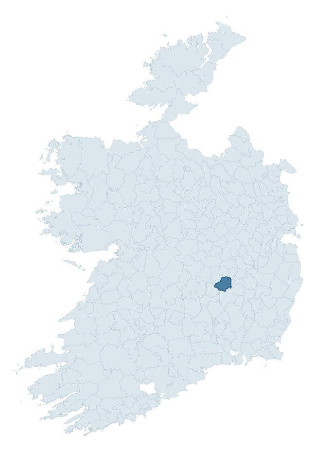
Where this barony sits in the Republic of Ireland
Geology and preservation
Bedrock geology shapes the landscape long before any settlement begins — controlling soil drainage, agricultural potential, the survival of upstanding monuments, and the preservation of buried archaeology. The figures below come from the Geological Survey Ireland 1:100,000 bedrock map.
The bedrock underlying Cullenagh is predominantly siltstone (36% of the barony by area), laid down during the Carboniferous period (100% by area, around 359 to 299 million years ago). Siltstone weathers to fertile, moderately heavy soils that supported Early Medieval ringfort agriculture, often interbedded with mudstone in lowland landscapes. A substantial secondary geology of limestone (31%) and sandstone (12%) adds further variety to the underlying landscape. The single largest mapped unit is the Killeshin Siltstone Formation (36% of the barony's bedrock). With 8 distinct rock types mapped, the barony sits in the top third of ROI baronies for geological diversity (82nd percentile) — typically a sign of complex tectonic history or coastal mosaics of differing rock units.
Rock type composition
Largest mapped unit: Killeshin Siltstone Formation (36% of the barony)
Placename evidence
Logainm records 15 heritage-diagnostic placenames for Cullenagh, drawn from townland and civil-parish names across the barony. The dominant stratum is Early Christian ecclesiastical — cill-, teampall-, and domhnach-prefixed names that record the dense network of early church foundations established between the fifth and tenth centuries. The leading diagnostic roots are cill- (7 — church), ráth- (3 — earthen ringfort), and lios- (2 — ringfort or enclosure). This is below the ROI average of 30.7 heritage placenames per barony, suggesting either lighter survey coverage or a townland-naming tradition that draws more on generic landscape vocabulary. The presence of multiple heritage strata side by side indicates layered occupation of the landscape across successive prehistoric and historic periods. Logainm records 102 placenames for Cullenagh (predominantly townland names). Of these, 15 (15%) carry one of the diagnostic Gaelic roots tracked above; the remainder draw on more generic landscape vocabulary that does not encode a heritage period.
Pre-Christian / Early Medieval Defensive
| Root | Count | Meaning |
|---|---|---|
| ráth- | 3 | earthen ringfort |
| lios- | 2 | ringfort or enclosure |
| caiseal- | 1 | stone ringfort |
Early Christian Ecclesiastical
| Root | Count | Meaning |
|---|---|---|
| cill- | 7 | church (early) |
| díseart- | 1 | hermitage |
Burial, Ritual, and Norse-Contact
| Root | Count | Meaning |
|---|---|---|
| sián- | 1 | fairy mound |
Other baronies in Laois
About this profile
Click any section below to expand.
What is a barony?
A barony is a historic administrative unit in Ireland, broadly equivalent to an English hundred. The 280 baronies used here are from the OSi 2019 National Statutory Boundaries (generalised 20m), covering the 26 counties of the Republic of Ireland. Baronies derive from the Norman period, were formalised in the 17th century, and have not been redrawn for statistical purposes. They vary enormously in area, from compact urban baronies in Dublin to vast upland baronies in Connacht, and should not be compared by raw site count without accounting for area differences.
What counts as a site?
This profile combines three distinct heritage registers, each with its own definition of what constitutes a recordable site:
- Archaeological sites (NMS). The National Monuments Service Sites and Monuments Record (SMR) catalogues every known archaeological monument or site of archaeological interest in the Republic, from prehistoric burial mounds and ringforts to medieval churches and post-medieval defensive works. Inclusion does not require legal protection — only that the site has been identified, surveyed, and assessed as having archaeological value. A separate subset of these sites lies within a recorded protection zone, which gives them statutory protection under the National Monuments Acts.
- Listed buildings (NIAH). The National Inventory of Architectural Heritage records buildings of architectural, historical, archaeological, artistic, cultural, scientific, social, or technical interest. Each surveyed structure is appraised on a five-tier scale: International, National, Regional, Local, and Record-Only. The NIAH appraisal is informational rather than strictly statutory, but it underpins local-authority Record of Protected Structures (RPS) listings.
- Heritage placenames (Logainm). Logainm is the authoritative database of Irish placenames maintained by the Placenames Branch. This profile applies a heritage-diagnostic classifier to the Irish-language form of each townland name, flagging roots that signal defensive sites (ráth-, lios-, dún-, caiseal-, cathair-), ecclesiastical foundations (cill-, teampall-, domhnach-, mainistir-), prehistoric burial-ritual features (tuaim-, carn-, leaba-), or Norse-contact settlement (gall-). Townlands without one of these diagnostic roots are not flagged here — they may still carry historical significance, but that significance is not encoded in the name itself.
Editorial principles
The narrative sections of this profile follow several explicit principles:
- Evidential. Every claim about this barony’s heritage character is anchored in the underlying register data. Where a site count, a placename count, or a percentile rank is cited, it is computed from the source datasets at export time, not estimated.
- Comparative. Counts and metrics are reported alongside their percentile rank against the other 279 ROI baronies. A barony with 50 ringforts in absolute terms could be unusually high or unusually low depending on its size and regional context; percentile ranking removes that ambiguity.
- Transparent on limits. Where a register has known coverage gaps, survey biases, or data-quality issues that affect this barony’s figures, the profile flags them rather than presenting the numbers as definitive.
- No interpretation beyond what the data supports. The narrative does not speculate about historical events, social dynamics, or cultural meaning beyond what the recorded heritage and placename evidence directly attests.
Data caveats and limits
- NMS Sites and Monuments Record is the product of survey campaigns conducted at different intensities across different counties and decades. Some baronies have been surveyed more thoroughly than others, and absolute counts should be read in that light. Sites destroyed by development before survey are typically not represented; sites in heavily forested or upland terrain are sometimes under-recorded.
- NIAH coverage is broadly complete for the Republic of Ireland but the survey was conducted on a rolling county-by-county basis, and the most recent appraisal date varies. Buildings demolished or substantially altered after their original survey may still appear in the register; conversely, recent buildings of merit may not yet have been appraised.
- Logainm classification applies a deliberately conservative pattern-matching approach to the Irish-language townland forms. The classifier prioritises true positives over recall: a townland may carry a heritage signal that the classifier doesn’t recognise, particularly where the diagnostic root has been heavily anglicised or where the townland name draws on a less common term. The 60,000+ townland records and ~9,800 classified placenames give a substantial signal at barony scale, but individual townland names should be checked against Logainm directly for definitive interpretation.
- Period attribution. The chronological distribution reflects only those NMS sites that carry a recognised period attribution in the source data. Sites listed as “Unknown” period are excluded from the dated subset.
- Boundary changes. Some baronies have undergone minor boundary adjustments since their 19th-century definition; the OSi 2019 generalised boundaries used here are the current statutory definition and may differ slightly from historical maps in border areas.
- Bedrock geology is mapped at 1:100,000 scale, which means local variation within a barony — small pockets of different rock type, mineral veins, alluvium overlying bedrock — is generalised. The dominant-system and rocktype figures are area-weighted, so a barony reading “70% Carboniferous limestone” may still contain small but archaeologically important pockets of older or younger rock. Around 3% of GSI polygons do not match the lexicon and contribute no rocktype or system attribution.
Data sources
- National Monuments Service — Sites and Monuments Record (SMR) https://data.gov.ie/dataset/national-monuments-service-archaeological-survey-of-ireland
- National Inventory of Architectural Heritage (NIAH) https://data.gov.ie/dataset/national-inventory-of-architectural-heritage-niah-national-dataset
- Logainm — Placenames Database of Ireland https://www.logainm.ie/
- Ordnance Survey Ireland — National Statutory Barony Boundaries 2019 https://data-osi.opendata.arcgis.com/
- EURODEM — European Digital Elevation Model https://www.mapsforeurope.org/datasets/euro-dem
- ESA WorldCover https://esa-worldcover.org/en
- Geological Survey Ireland — 1:100,000 Bedrock Geology https://www.gsi.ie/en-ie/data-and-maps/Pages/Bedrock.aspx
Explore more: Search any of the 280 ROI baronies, browse by historical province, or read the methodology and data sources for the full Republic of Ireland Heritage Tool.