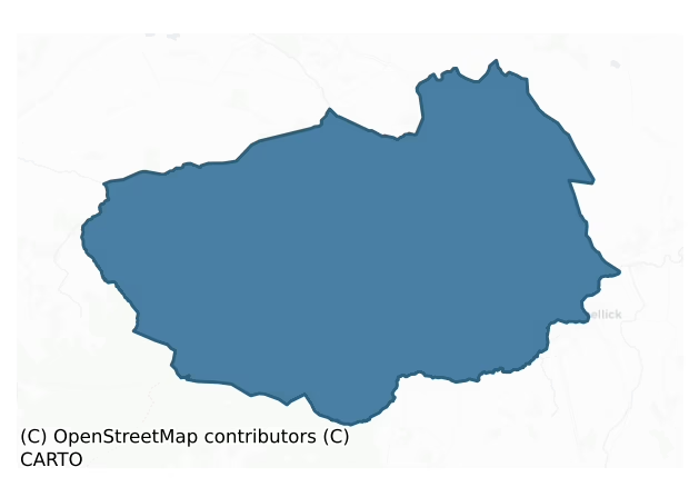
Tinnahinch is a barony of County Laois, in the historical province of Leinster (Irish: Tigh na hInse), covering 220 km² of land. The barony records 100 NMS archaeological sites and 68 NIAH listed buildings, placing it at around the 1st percentile among 280 ROI baronies for sites per km². This means it is in the bottom tenth of all baronies for sites per km². Dated archaeological evidence runs from the Neolithic through to the Modern, spanning 7 of 9 archaeological periods, placing the barony in the 28th percentile among 280 ROI baronies for chronological depth. This means it is in the bottom third of all baronies for chronological depth. The largest dated subset of recorded sites dates to the Early Medieval.
Heritage at a glance
Percentile rankings throughout this profile compare each barony only against the other 279 Republic of Ireland baronies.
The recorded heritage of Tinnahinch
The National Monuments Service Sites and Monuments Record (SMR) is the statutory inventory of archaeological sites for the Republic of Ireland, maintained by the Department of Tourism, Culture, Arts, Gaeltacht, Sport and Media. Sites recorded here include earthworks, ringforts, megalithic tombs, ecclesiastical remains, and post-medieval features; not every record is legally protected, but each is registered as a monument of archaeological interest.
The National Monuments Service records 100 archaeological sites in Tinnahinch, putting it at the 1st percentile among 280 ROI baronies for sites per km². This means it is in the bottom tenth of all baronies for sites per km². A sparse recorded total of this kind in Ireland often reflects survey priority rather than genuine absence of past activity. Protection coverage is near-universal — 94 sites (94%) fall within a recorded monument protection zone, indicating an extensively surveyed landscape. The record is dominated by defensive sites — ringforts, enclosures, hillforts, and stone forts (37 sites, 37% of the total), with ecclesiastical sites forming a substantial secondary presence (35 sites, 35%). The most diagnostically specific type is Graveyard (8 records, 8% of the barony's NMS total) — compared to an ROI average of 4% across all baronies where this type occurs. Graveyard is a burial area associated with a church, in use from the medieval period onwards. The broader 'Enclosure' classification — which catches unclassified ringforts and field enclosures — accounts for a further 17 records (17%) and reflects the difficulty of sub-classifying degraded earthworks from surface evidence alone. Across the barony's 220 km², this gives a recorded density of 0.46 sites per km².
Most common monument types
Hover or tap a monument type to see its definition.
| Type | Count |
|---|---|
| Enclosure a banked or ditched feature of uncertain type, used as a catch-all where the original function cannot be determined from surface evidence | 17 |
| Graveyard a burial area associated with a church, in use from the medieval period onwards | 8 |
| Cross-slab a stone slab inscribed with a cross, used as a grave-marker or memorial, dated pre-1200 AD | 8 |
| Church a building used for public Christian worship, of any date from c. 500 AD onwards | 7 |
| Ringfort – rath an earthen ringfort enclosed by a bank and external ditch — the most common Early Medieval farmstead, broadly dated 500–1000 AD | 6 |
| Ritual site – holy well a well or spring traditionally associated with a saint, often credited with healing properties; many trace earlier ritual origins but devotion is documented from the medieval period onwards | 4 |
| Bawn the defended courtyard of a medieval house, tower house or fortified house | 3 |
Chronological distribution
The dated archaeological record for Tinnahinch spans from the Neolithic through to the Modern, with activity attested across 7 of 9 archaeological periods. The record is near-continuous, with only the Middle Late Bronze Age period falling inside the span without any recorded sites. Activity concentrates most heavily in the Early Medieval (36 sites, 43% of dated material), with the Iron Age forming a secondary peak (24 sites, 29%). A further 16 recorded sites (16% of the overall NMS register for the barony) carry no period attribution — appearing as 'Unknown' in the bar chart below. This typically reflects either records that pre-date the standardised period vocabulary or sites awaiting specialist dating review, rather than a genuine absence of chronological evidence.
Sample of recorded monuments
Show 25 sample monuments (of 100 total)
A representative sample of 25 recorded monuments drawn from the barony’s 100 total NMS entries. Sites within a recorded monument protection zone and rarer site types are prioritised so the list shows a meaningful cross-section rather than only the most common type. Each entry shows the official Sites and Monuments Record reference number and the description published by the National Monuments Service.
Settlement deserted – medieval
SW and down-slope from the ruined tower house (LA001-004001-), church (LA001-004003-) and graveyard (LA001-004-) appears to have been the site of a deserted medieval village. Slight remains of earthworks visible. Walls…
SW and down-slope from the ruined tower house (LA001-004001-), church (LA001-004003-) and graveyard (LA001-004-) appears to have been the site of a deserted medieval village. Slight remains of earthworks visible. Walls c. 1m thick discovered some years ago in this area.
In the O'Doyne Manuscript, it claims that Tadhg Mac Laighnigh Ui Duinn (O'Doyne/Dunne) in 1475 was the builder of this castle (K.W. Nicholls (ed.) 1983, p. 116-7.). In 1608 the castle is described as 'a castle , hall, parlour at end of hall, kitchen, brewhouse, Bakehouse and the rest of the houses within the bawn the haggart and bawns on S side of castle, the garden, the orchard, the parke, the stable and houses for cattle on the west side and also the houses and tenements for tenants and other uses on N and W parts of the said town of Castlebrack (Nicholls (ed.) 1983, 40).
Archaeological testing in the vicinity of the tower house and deserted settlement was carried out by John Purcell in 2004 under excavation licence no. 04E1048.
The above description is derived from the published 'Archaeological Inventory of County Laois' (Dublin Stationery Office, 1995) compiled by P. David Sweetman, Olive Alcock and Bernie Moran. In certain instances the entries have been revised and updated in the light of recent research.
Date of upload: 17 December 2007
Structure
Originally listed in the SMR of Laois as a possible castle site located to S of the Roman Catholic church at Clonaslee. However the structure located on the lands of Mr. John Moran was recorded by Henry Wheeler,…
Originally listed in the SMR of Laois as a possible castle site located to S of the Roman Catholic church at Clonaslee. However the structure located on the lands of Mr. John Moran was recorded by Henry Wheeler, Inspector of Monuments with the Office of Public Works in 1967 and was described as follows; 'On E bank of Clodiagh River. Piece of wall 2 ft. (0.6m) thick at existing top, height at present 3' 6"-4' (1.2m). Two offsets at base. Masonry of indeterminate character runs NW-SE. Visible for about 15' (4.5m). A pit has been dug for a tank just outside it (full of water to a depth of several inches). Traces of 2 other walls roughly at right angles in the yard of the owner. If so the exposed wall would be the N.E. side of a rectangular block. Owner thinks sides are c. 45' (13.7m) long, but I could not readily verify this. Bears no relationship to village street of Clonaslee or to oldish farm buildings at back which must be c. 150 years old. These overlie it and are different buildings. Wall is a bit thin for a castle. Water gushed from inside it. ? Water mill. 1839 edition of 6" OS map shows what seems to be this building: no indication of its purpose. It was roughly square, with small annexes at NW & SE corners: no building on street front : apparently a yard there' (SMR File 17 May 1967). The structure recorded in 1967 was deemed not to be the site of a castle and was delisted from the SMR for Co. Laois and was not listed in the RMP for Co. Laois. The site report…
Ritual site – holy tree/bush
Whitethorn bush marked as Fairy Bush on all editions of the OS 6-inch maps.
Compiled by: Caimin O'Brien
Date of upload: 17 December 2007
House – medieval
On slightly elevated site at E side of Glenlahan. Reference to the site of a tower house or fortified house, thought to have been built by Teige Oge O'Doyne c. 1551 (Crossdaile 1959, 12). Site of seventeenth century…
On slightly elevated site at E side of Glenlahan. Reference to the site of a tower house or fortified house, thought to have been built by Teige Oge O'Doyne c. 1551 (Crossdaile 1959, 12). Site of seventeenth century house and bawn (LA002-018003-) situated on slighly elevated ground close to E bank of Glenlahan river. All that remains is W wall of bawn (LA002-018003-) which has three simple splayed gun opes and part of an angle tower at its N end. Bridge (LA002-018002-) which crosses the river and gives access to the house may be early seventeenth century and contemporary with it. A nineteenth century single storey four bay derelict farmhouse (ext. dims. N-S 18m ; E-W 6.2m; wall T 0.6m) orientated on a N -S axis stands on top of a seventeenth century house which is contemporary with the bawn wall (LA002-018003-). The basement of the seventeenth century house was filled in to provide foundations for the farmhouse which has a byre (int. dims. N-S 4.6m ; E-W 5m) at the S end. The concrete floor of the farmhouse has been ripped up in the N room off the kitchen of the farmhouse revealing the basement of an earlier building underneath. This earlier chamber (int. dims. N-S 3.38m; E-W 1.87m; wall T 1.2m) is partly below the ground and is not a true basement and is similar to the ground floors of other seventeenth century fortified houses. There is a blocked up window lighting this chamber in the centre of the N wall and a stone ledge or shelf running N-S along the inner face of the…
Bridge
Over River Glenlahan in mountain valley. Small narrow single-eyed humpbacked bridge (Wth 2.85m) which gives access to seventeenth century house (LA002-18001-) and bawn (LA002-018003-) marked 'Turrets' on OS 6-inch map.…
Over River Glenlahan in mountain valley. Small narrow single-eyed humpbacked bridge (Wth 2.85m) which gives access to seventeenth century house (LA002-18001-) and bawn (LA002-018003-) marked 'Turrets' on OS 6-inch map. Built with rubble sandstone and founded on bedrock. No evidence of plank or wattle centring in the barrel vault of the bridge, the elliptical arch measures 3.85m wide. The size and shape of this structure and its position in relation to the seventeenth century house would suggest a late-medieval date.
The above description is derived from the published 'Archaeological Inventory of County Laois' (Dublin Stationery Office, 1995) compiled by P. David Sweetman, Olive Alcock and Bernie Moran. In certain instances the entries have been revised and updated in the light of recent research.
Date of upload: 17 December 2007
Children's burial ground
Possible killeen consisting of a flat subcircular area enclosed by a modern hedge and iron railings; no surface evidence of grave-markers, stonework etc. which might indicate the exact type of site.
The above…
Possible killeen consisting of a flat subcircular area enclosed by a modern hedge and iron railings; no surface evidence of grave-markers, stonework etc. which might indicate the exact type of site.
The above description is derived from the published 'Archaeological Inventory of County Laois' (Dublin Stationery Office, 1995) compiled by P. David Sweetman, Olive Alcock and Bernie Moran. In certain instances the entries have been revised and updated in the light of recent research.
Date of upload: 17 December 2007
House – 17th century
Brittas House current house was constructed in the nineteenth century possibly built on or near to the site of an earlier dwelling of seventeenth century date. The house was described in 1978 as a 'Castellated house of…
Brittas House current house was constructed in the nineteenth century possibly built on or near to the site of an earlier dwelling of seventeenth century date. The house was described in 1978 as a 'Castellated house of sandstone with limestone dressings built 1869 by Major Gen Rt Hon Francis Plunkett Dunne, MP, to the design of John McCurdy' (Bence-Jones 1978, 48). In 1990 this building was recorded as a 'Castellated house with terraces to E and built of hammer dressed limestone which has fine drafting on its edges. There is a castellated gate tower with entranceway of four pointed arches, the inner three being of brick and the outermost of limestone. The gate tower stands close to the NE angle and gave access to a courtyard. The outer arch of the gateway has limestone roll mouldings. Window at first floor level over the archway is a three-light oriel built with sandstone. The rest of the house is very ruined in some instances down to its foundations' (SMR File 1990).
Described by the National Inventory of Architectural Heritage as the 'Remains of detached country house, built in 1869 to designs by John McCurdy, comprising three-storey over basement tower. Remainder of house dismantled to ground level. No roof to main structure. Sandstone ashlar walls with buttresses and castellated parapet to turret on corbels. Pointed-arch window openings to ground floor, square-headed window openings to upper floors and canted oriel window to first floor with sandstone surrounds. Four-…
Round tower
Unlocated Round tower within the village of Rosenallis, marked on current edition of the OS 6-inch map as site of Round Tower. No surface remains visible. O'Donovan describes how an old man remembered a 'narrow steeple…
Unlocated Round tower within the village of Rosenallis, marked on current edition of the OS 6-inch map as site of Round Tower. No surface remains visible. O'Donovan describes how an old man remembered a 'narrow steeple of rough masonry, not so high or well built as the Steeple of Timahoe'. Tradition ascribes its erection to O'Dun, Chief of Dooregan. It was pulled down some years ago by the Minister (O'Flanagan 1933, vol. 1, p. 69). The OS Letters of 1838 recorded the demolition of the round tower by the 'Minister [who] pulled down a slender steeple which stood opposte the door of this church (LA003-016002-), because he found that it was in his way, and converted the stone to a more useful purpose than they had served, while piled together in the shape of a steeple since the time of St. Bridget, that is to indulge the curiosity of a number of cracked people called antiquarians and to serve as a habitation for jackdaws' (O'Flanagan 1933, 57). Sir Charles Coote described the monument as located beside the church and contiguous to it 'stands the walls of a round tower, but not one third as high as those circular towers seen thro the kingdom, nor evidently was it built for the like purpose. The walls of a windmill stand at some distance from the village and bear strong resemblance to the tower just described, but the former has no entrance' (O'Flanagan 1933, 69). The location of this tower was recorded as 'The round tower stood between the gable-end of the old Protestant school…
Settlement cluster
Unlocated medieval and seventeenth century settlement in and around the vicinity of the church and graveyard and the village of Rosenallis. Quaker settlement in Rosenallis by 1660 when there were at least 20 Quaker…
Unlocated medieval and seventeenth century settlement in and around the vicinity of the church and graveyard and the village of Rosenallis. Quaker settlement in Rosenallis by 1660 when there were at least 20 Quaker families (Feehan 1983, 399)
Archaeological testing in the village of Rosenallis was carried out by Ellen O'Carroll in 2004 under excavation licence no. 04E0047.
Compiled by: Caimin O'Brien
Date of upload: 17 December 2007
Burial ground
Friends Burial ground, almost square shaped area, walled and well-kept graves. No head stones pre-1700 AD in date. The present village of Rosenallis was founded by the Quakers in the second half of the 17th century.…
Friends Burial ground, almost square shaped area, walled and well-kept graves. No head stones pre-1700 AD in date. The present village of Rosenallis was founded by the Quakers in the second half of the 17th century. William Edmundson came to Ireland from Scotland and settled first in Virginia in Co. Cavan and then settled in Mountmellick and Rosenallis in 1659. William Edmundson died in 1712 and is buried in the Quaker burial ground in Rosenallis, the oldest in Ireland. The plaque near his grave reads – "Near this spot is buried William Edmundson, the first member of the Society of Friends who settled in Ireland. Died 31st of 6th Month 1712 (old style). Aged nearly 85 years." (www.rosenallis.com)
Compiled by: Caimin O'Brien
Date of upload/revision: 15 September 2010
Metalworking site
No surface evidence of any ironworking in field marked on OS 6-inch map, field in spring wheat when visited. Site of seventeenth century Ironworks set up by Sir Charles Coote located in fork between Owenass River and…
No surface evidence of any ironworking in field marked on OS 6-inch map, field in spring wheat when visited. Site of seventeenth century Ironworks set up by Sir Charles Coote located in fork between Owenass River and River Barrow (Feehan 1983, 338). The Mountrath works were located in the townland of Forest, south of the modern town, in the angle made by the Nore and Mountrath Rivers, this piece of land still bears the name of 'Forgeland' (Feehan 1983, 338).
Compiled by: Caimin O'Brien
Date of upload: 17 December 2007
Megalithic tomb – unclassified
The site, in a clear-felled area of forest, lies just uphill from a stream on the W slope of Barradoos Mountain which is on the N side of the Slieve Bloom range. A stone, 2.30m long, 70cm thick and 70cm high, aligned…
The site, in a clear-felled area of forest, lies just uphill from a stream on the W slope of Barradoos Mountain which is on the N side of the Slieve Bloom range. A stone, 2.30m long, 70cm thick and 70cm high, aligned N-S, seems to be set. Alongside to the W are four prostrate stones measuring 1.50m to 2.10m in maximum dimension and a fifty partly-buried. There may have been some form of megalithic structure here but its nature is notknown. According to a local story the stones were dislodged by the soldiery in 1798. (de Valera and O Nuallain 1972, 97, No. 1.).
The above description is derived from the published 'Archaeological Inventory of County Laois' (Dublin Stationery Office, 1995) compiled by P. David Sweetman, Olive Alcock and Bernie Moran. In certain instances the entries have been revised and updated in the light of recent research.
Date of upload: 17 December 2007
Earthwork
Shown as a circular mound or platform (diam. c. 25m) on 1841 and 1888 editions of the OS 6-inch maps. No visible surface remains.
The above description is derived from the published 'Archaeological Inventory of…
Shown as a circular mound or platform (diam. c. 25m) on 1841 and 1888 editions of the OS 6-inch maps. No visible surface remains.
The above description is derived from the published 'Archaeological Inventory of County Laois' (Dublin Stationery Office, 1995) compiled by P. David Sweetman, Olive Alcock and Bernie Moran. In certain instances the entries have been revised and updated in the light of recent research.
Date of upload: 17 December 2007
Hillfort
An enclosure (max. dims. c. 100m N-S, c. 90m E-W), surrounding the top of a hill, defined by a bank with an entrance at NNW visible on aerial photograph taken c. 1950 (ACAP, V 300, 731-2). The area is now covered with…
An enclosure (max. dims. c. 100m N-S, c. 90m E-W), surrounding the top of a hill, defined by a bank with an entrance at NNW visible on aerial photograph taken c. 1950 (ACAP, V 300, 731-2). The area is now covered with forestry but the remains of earthen bank (H c. 2m, Wth 1.5m), much interfered with, may be in part original. No evidence of fosse. This site might be classified as a hilltop enclosure.
The hillfort was recently described in the Atlas of Hillforts of Britain and Ireland as following; 'Near the modern town of Rosenallis, a circular contour fort positioned in a commanding position at the NE end of a hill ridge known as the 'Ridge of Capard'. The site measures about 100m N-S by 90m E-W and has a total site footprint of approximately 0.9ha. The site is strategically positioned overlooking the River Barrow to the NE and has excellent views of low-lying terrain to the NW, N, E and S and along the crest of the ridge to the SW. Much of the hill ridge, including the contour fort itself, is covered in dense forestry. This has affected the univallate enclosing elements and has prevented detailed survey of the monument. The bank is earthen and measures approximately 2m high an 1.5m wide. A simple entrance feature was identified in Cambridge aerial photographs at the NNW. There are no obvious internal features visible on the surface. The site was first depicted in the second edition Ordnance Survey maps as a circular enclosure. Site survey by Sweetman in 1995.'(http://hil…
Barrow – bowl-barrow
Visible on aerial photographs (ACAP, V 300 736-7) as an embanked enclosure. The area surrounding the site is planted with young trees and is impenetrable with scrub, briars and gorse.
The above description is derived…
Visible on aerial photographs (ACAP, V 300 736-7) as an embanked enclosure. The area surrounding the site is planted with young trees and is impenetrable with scrub, briars and gorse.
The above description is derived from the published 'Archaeological Inventory of County Laois' (Dublin Stationery Office, 1995) compiled by P. David Sweetman, Olive Alcock and Bernie Moran. In certain instances the entries have been revised and updated in the light of recent research.
Date of upload: 17 December 2007
Situated in coniferous plantation on a low rise of ground on SE facing slope of poorly drained land in the Slieve Bloom mountains. Present remains consist of a large round-topped oval-shaped burial mound (approx. base dims. 10m x 16m; H 1.5-2.2m) enclosed around the base of the mound with an external fosse (Wth2m; ext. D 0.4m) which is waterlogged in places. Located in an area of coniferous plantation with a drainage ditch associated with the forestry running across the centre of the bowl barrow. No other features visible.
Mound
Hachured as 3/4 of an almost circular mound on 1838 ed OS 6-inch map and planted with trees but not marked on 1910 edition No visible surface remains.
The above description is derived from the published…
Hachured as 3/4 of an almost circular mound on 1838 ed OS 6-inch map and planted with trees but not marked on 1910 edition No visible surface remains.
The above description is derived from the published 'Archaeological Inventory of County Laois' (Dublin Stationery Office, 1995) compiled by P. David Sweetman, Olive Alcock and Bernie Moran. In certain instances the entries have been revised and updated in the light of recent research.
Date of upload: 17 December 2007
Hermitage
Unlocated structure within townland of Glenbarrow, indicated on first edition of the OS 6-inch map as Hermit's Cell but not indicated on current edition.
Compiled by: Caimin O'Brien
Date of upload: 17 December 2007
Historic town
No town is depicted in Mountmellick on the 1563 Map of Laois and Offaly, nor does Mountmellick appear as a town on the Down Survey (1655-6) map of Laois prepared by Sir William Petty. In 1631 the town was granted a…
No town is depicted in Mountmellick on the 1563 Map of Laois and Offaly, nor does Mountmellick appear as a town on the Down Survey (1655-6) map of Laois prepared by Sir William Petty. In 1631 the town was granted a Royal Licence to Sir Robert Loftus so that he could hold a Saturday market and two annual fairs in Mountmellick. In 1659 William Edmundson and others settled in Mountmellick where they established a Quaker settlement amongst the English colony. In an entry dated 1669 in the diary of William Penn it is stated that Mountmellick was originally an English colony set up alongised a frontier garrison, which had been situated on the bank of the Owenass River (Dunne, p. 11). In 1685 the town had grown and was now included in a set of maps produced by Sir William Petty. In 1691 there was a Williamite garrison in Mountmellick consisting of 300 infantry and 50 calvary, along with about 120 local militia.
The presence of a church of Ireland chapel of ease in Mountmellick can be traced back as far as 1665, the year in which George Clapham, Rector of Mountmellick died. This chapel was repaired in 1736 and again in 1807.
Archaeological monitoring in Patrick St. was carried out by Martin Byrne in 2002 under excavation licence no. 02E0231.
Compiled by: Caimin O'Brien
Date of upload: 17 December 2007
House – 16th/17th century
Land grant in the Calendar of Patent Rolls for James I in 1623 records the following land grant to Giles Rawlins under the plantation of Queens County the lands of Reary More and states that he should 'hold in free and…
Land grant in the Calendar of Patent Rolls for James I in 1623 records the following land grant to Giles Rawlins under the plantation of Queens County the lands of Reary More and states that he should 'hold in free and common soccage; all ancient glebes, rectories and vicarages excepted; with power to make tenures; to enjoy all waifs and strays; to have free warren and all tithes great and small; bound to build a mansion house, with a bawn 200 feet in circuit or to forfeit 300 l (pounds). Subject to the conditions of the Plantation of Queens county as an undertaker.' (Cal. Pat. Rolls. James I, p. 540, entry no. I). Located 65m to the SW of the church and graveyard of Rearymore (LA003-003001-) there is a two storey 8 bay house with a two storey porch off centre to N. The house is E facing and is orientated on a N-S axis. It is a multiperiod building which has been extended to the E by the addition of three bays. Originally the house appears to have been a single pile 5 bay two storey gable ended house with two storey Jacobean style porch in centre of E façade. There is datestone or marriage stone over the doorway of the porch which reads 'July the 1st 1771 M..M'. This porch or datestone may have been added when the house to commemorate the house extension in the 18th century. According to the current house owner the original S gable chimney stack protruded externally beyond the S gable. Only recently has this wall been re-plastered and the external chimney stack has been re…
Well
Remains of a well located 73m to the SE of the castle (LA001-004001-) at Castlebrack which may be medieval in date.
Compiled by: Caimin O'Brien
Date of upload: 17 December 2007
Moated site
Marked on 1888 and 1909 editions of the OS 6-inch maps; an irregular enclosure (max. dims. c. 60m ENE-WSW). No visible surface remains. Depicted on first edition of the OS 6-inch map as a subrectangular enclosure and on…
Marked on 1888 and 1909 editions of the OS 6-inch maps; an irregular enclosure (max. dims. c. 60m ENE-WSW). No visible surface remains. Depicted on first edition of the OS 6-inch map as a subrectangular enclosure and on the current edition as a semi-circular or D-shaped enclosure. No surface remains visible at time of inspection as field was in tillage. Shape of monument on first edition of the OS 6-inch map would suggest that it may have been a moated site. Subrectangular enclosure (approx. dims. 50m E-W; 44m N-S) with straight side at NE (L 45m) which is intersected at NW by a field boundary now removed running on a NE-SW axis. Site was probably levelled when field boundary removed.
The above description is derived from the published 'Archaeological Inventory of County Laois' (Dublin Stationery Office, 1995) compiled by P. David Sweetman, Olive Alcock and Bernie Moran. In certain instances the entries have been revised and updated in the light of recent research.
Castle – tower house
Marked on the 1841 edition of the OS 6-inch map. Situated atop high ground site has been levelled and appears as grass-covered wall foundations. Depicted on first edition of the OS 6-inch map as an L-shaped building…
Marked on the 1841 edition of the OS 6-inch map. Situated atop high ground site has been levelled and appears as grass-covered wall foundations. Depicted on first edition of the OS 6-inch map as an L-shaped building with its long axis orienated on an E-W axis.
The above description is derived from the published 'Archaeological Inventory of County Laois' (Dublin Stationery Office, 1995) compiled by P. David Sweetman, Olive Alcock and Bernie Moran. In certain instances the entries have been revised and updated in the light of recent research.
Date of upload: 17 December 2007
Castle – tower house
Erected by the Dunne family in 1427 (Crossdaile 1959, 13). Situated c. 25m to SSE of Castlebrack church (LA001-004003-) and at a lower level. Consists of a pile of featureless rubble but probably measured 20m E-W.…
Erected by the Dunne family in 1427 (Crossdaile 1959, 13). Situated c. 25m to SSE of Castlebrack church (LA001-004003-) and at a lower level. Consists of a pile of featureless rubble but probably measured 20m E-W. Remains of bawn wall at S with ditch outside it at E and S. Castle appears to have been situated in the centre of a large circular enclosure defined by an earth and stone bank and outer fosse with entrance gap at W. This enclosure or ringwork appears to be the earthen foundations of a bawn wall (LA001-004006-) that enclosed the castle.
Situated c. 25m to SSE of Castlebrack church (LA001-004003-) and graveyard (LA001-004-) and at a lower level. Consists of a pile of featureless rubble but probably measured 20m E-W. Remains of bawn wall (LA001-004006-) at S with ditch outside it at E and S. In the O'Doyne Manuscript, it claims that Tadhg Mac Laighnigh Ui Duinn (Dunne) (O'Doyne) in 1475 was the builder of this castle (Nicholls 1983, 116-7.). In 1608 the castle is described as 'a castle , hall, parlour at end of hall, kitchen, brewhouse, Bakehouse and the rest of the houses within the bawn the haggart and bawns on S side of castle, the garden, the orchard, the parke, the stable and houses for cattle on the west side and also the houses and tenements for tenants and other uses on N and W parts of the said town of Castlebrack (Nicholls 1983, 40). Described by O'Hanlon as 'a castle once strong and stately, hade been erected by the Dunne family. Its last inhabitant was…
House – fortified house
Situated in flat low-lying land. A large limestone-built, semi-fortified house (max. dims. 30.25m by 20.5m, wall T 1.3m and 0.9m) of H-plan with projecting wings at either end of a central rectangular block. Jacobean…
Situated in flat low-lying land. A large limestone-built, semi-fortified house (max. dims. 30.25m by 20.5m, wall T 1.3m and 0.9m) of H-plan with projecting wings at either end of a central rectangular block. Jacobean type chimney stacks and associated fire places similar to those at Ballynakill castle (LA002-011—-). No evidence of outer defences. Would appear to be a mid to late seventeenth century building. Possibly built as early as 1560 by Sir Charles Coote, in the rebellion of 1641 the castle was abandoned and has since fallen into ruins.
H-Plan house with front façade facing S, central rectangular block flanked on E and W by tall projecting rectangular towers surmounted by tall chimney stacks. Central recessed block set back 4.85m from front of projecting flanking wings. N walls built of roughly coursed limestone rubble with good evidence of external render with false quoins stones depicted with smooth finish of render and through use of alternating colour of black and white quoins, this treatment of the quoins has also been applied to the window surrounds. Front door in centre of S façade of recessed central block. Fireplaces in both flanking wings which were probably the private chambers with the public rooms contained within the central block.
The above description is derived from the published 'Archaeological Inventory of County Laois' (Dublin Stationery Office, 1995) compiled by P. David Sweetman, Olive Alcock and Bernie Moran. In certain instances the e…
Enclosure
Polygonal shaped enclosure identified on aerial photograph (GSIAP N 205-06; 406-07; Swan 35BWN_00091_31). Polygonal shape of field boundary on S side of monument may represent part of the monument identified from…
Polygonal shaped enclosure identified on aerial photograph (GSIAP N 205-06; 406-07; Swan 35BWN_00091_31). Polygonal shape of field boundary on S side of monument may represent part of the monument identified from aerial photographs. Slightly elevated site in generally low lying area. Nothing can be seen of this possible site from the ground except for a depression at the N side which may be part of the enclosure.
Compiled by: Caimin O'Brien
Date of upload: 17 December 2007
Listed buildings
The National Inventory of Architectural Heritage (NIAH) is a state survey appraising buildings of architectural, historical, archaeological, artistic, cultural, scientific, social, or technical interest. Each surveyed structure receives a rating from International (the highest, for buildings of European importance) through National, Regional, Local, and Record-Only.
The NIAH records 68 listed buildings in Tinnahinch (36th percentile across ROI baronies). The highest-graded structure include 1 of National significance. The Republic holds 937 National-graded buildings in total, so this barony accounts for around 0% of the national total. Construction dates concentrate most heavily in the Victorian (1830-1900) period.
Terrain and environment
Mean elevation across the barony is 158m — the 88th percentile among 280 ROI baronies for elevation. This means it is in the top fifth of all baronies for elevation. This is a relatively elevated landscape by ROI standards. Elevation matters for heritage because higher-altitude baronies typically favour defensive monuments — ringforts and hilltop forts placed on prominent ground — while lowland baronies are more likely to carry the dense settlement and church networks of intensive agricultural landscapes. The barony reaches 508m at its highest point — a vertical span of more than 350m within its boundary, indicating significant topographic diversity. Mean slope is 3.7° — the 50th percentile among 280 ROI baronies for slope. This means it is in the upper half of all baronies for slope. Slope is a key control on both land use and archaeological preservation: steep ground resists ploughing and tends to preserve earthworks intact, while gentle slopes favour intensive cultivation that damages or destroys surface archaeology over time. The Topographic Wetness Index averages 11.0, the 55th percentile among 280 ROI baronies for wetness. This means it is in the upper half of all baronies for wetness. Drainage matters for heritage because poorly-drained ground preserves organic archaeology (wooden trackways, leather, textiles, and on rare occasions human remains) far better than free-draining soil; well-drained ground favours arable use but destroys organic material rapidly. The land cover is dominated by improved grassland (66%) and woodland (28%). In overall character, this is elevated but relatively gentle terrain — typical of plateau country, with land use dominated by improved grassland.
Terrain measurements
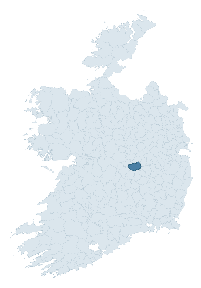
Where this barony sits in the Republic of Ireland
Geology and preservation
Bedrock geology shapes the landscape long before any settlement begins — controlling soil drainage, agricultural potential, the survival of upstanding monuments, and the preservation of buried archaeology. The figures below come from the Geological Survey Ireland 1:100,000 bedrock map.
The bedrock underlying Tinnahinch is predominantly limestone (51% of the barony by area), laid down during the Carboniferous period (55% by area, around 359 to 299 million years ago). Limestone is the most heritage-rich bedrock in Ireland. It supports fertile, well-drained soils that favoured dense Early Medieval settlement and Norman manorial agriculture, and it weathers into karst features — sinkholes, caves, swallow holes, and souterrains — that frequently carry archaeology. Where peat overlies limestone, organic preservation can be exceptional. A substantial secondary geology of sandstone (26%) and sandstone, siltstone (18%) adds further variety to the underlying landscape. The single largest mapped unit is the Ballysteen Formation (47% of the barony's bedrock).
Rock type composition
Largest mapped unit: Ballysteen Formation (47% of the barony)
Placename evidence
Logainm records 10 heritage-diagnostic placenames for Tinnahinch, a modest sample drawn predominantly from the townland record. The dominant stratum is early christian ecclesiastical. The most frequent diagnostic roots are cill- (5) and ráth- (1). With a sample of this size the count should be treated as indicative rather than definitive.
Pre-Christian / Early Medieval Defensive
| Root | Count | Meaning |
|---|---|---|
| ráth- | 1 | earthen ringfort |
| lios- | 1 | ringfort or enclosure |
Early Christian Ecclesiastical
| Root | Count | Meaning |
|---|---|---|
| cill- | 5 | church (early) |
| gráinseach- | 1 | monastic farm / grange |
Burial, Ritual, and Norse-Contact
| Root | Count | Meaning |
|---|---|---|
| leacht- | 1 | grave monument |
| sián- | 1 | fairy mound |
Other baronies in Laois
About this profile
Click any section below to expand.
What is a barony?
A barony is a historic administrative unit in Ireland, broadly equivalent to an English hundred. The 280 baronies used here are from the OSi 2019 National Statutory Boundaries (generalised 20m), covering the 26 counties of the Republic of Ireland. Baronies derive from the Norman period, were formalised in the 17th century, and have not been redrawn for statistical purposes. They vary enormously in area, from compact urban baronies in Dublin to vast upland baronies in Connacht, and should not be compared by raw site count without accounting for area differences.
What counts as a site?
This profile combines three distinct heritage registers, each with its own definition of what constitutes a recordable site:
- Archaeological sites (NMS). The National Monuments Service Sites and Monuments Record (SMR) catalogues every known archaeological monument or site of archaeological interest in the Republic, from prehistoric burial mounds and ringforts to medieval churches and post-medieval defensive works. Inclusion does not require legal protection — only that the site has been identified, surveyed, and assessed as having archaeological value. A separate subset of these sites lies within a recorded protection zone, which gives them statutory protection under the National Monuments Acts.
- Listed buildings (NIAH). The National Inventory of Architectural Heritage records buildings of architectural, historical, archaeological, artistic, cultural, scientific, social, or technical interest. Each surveyed structure is appraised on a five-tier scale: International, National, Regional, Local, and Record-Only. The NIAH appraisal is informational rather than strictly statutory, but it underpins local-authority Record of Protected Structures (RPS) listings.
- Heritage placenames (Logainm). Logainm is the authoritative database of Irish placenames maintained by the Placenames Branch. This profile applies a heritage-diagnostic classifier to the Irish-language form of each townland name, flagging roots that signal defensive sites (ráth-, lios-, dún-, caiseal-, cathair-), ecclesiastical foundations (cill-, teampall-, domhnach-, mainistir-), prehistoric burial-ritual features (tuaim-, carn-, leaba-), or Norse-contact settlement (gall-). Townlands without one of these diagnostic roots are not flagged here — they may still carry historical significance, but that significance is not encoded in the name itself.
Editorial principles
The narrative sections of this profile follow several explicit principles:
- Evidential. Every claim about this barony’s heritage character is anchored in the underlying register data. Where a site count, a placename count, or a percentile rank is cited, it is computed from the source datasets at export time, not estimated.
- Comparative. Counts and metrics are reported alongside their percentile rank against the other 279 ROI baronies. A barony with 50 ringforts in absolute terms could be unusually high or unusually low depending on its size and regional context; percentile ranking removes that ambiguity.
- Transparent on limits. Where a register has known coverage gaps, survey biases, or data-quality issues that affect this barony’s figures, the profile flags them rather than presenting the numbers as definitive.
- No interpretation beyond what the data supports. The narrative does not speculate about historical events, social dynamics, or cultural meaning beyond what the recorded heritage and placename evidence directly attests.
Data caveats and limits
- NMS Sites and Monuments Record is the product of survey campaigns conducted at different intensities across different counties and decades. Some baronies have been surveyed more thoroughly than others, and absolute counts should be read in that light. Sites destroyed by development before survey are typically not represented; sites in heavily forested or upland terrain are sometimes under-recorded.
- NIAH coverage is broadly complete for the Republic of Ireland but the survey was conducted on a rolling county-by-county basis, and the most recent appraisal date varies. Buildings demolished or substantially altered after their original survey may still appear in the register; conversely, recent buildings of merit may not yet have been appraised.
- Logainm classification applies a deliberately conservative pattern-matching approach to the Irish-language townland forms. The classifier prioritises true positives over recall: a townland may carry a heritage signal that the classifier doesn’t recognise, particularly where the diagnostic root has been heavily anglicised or where the townland name draws on a less common term. The 60,000+ townland records and ~9,800 classified placenames give a substantial signal at barony scale, but individual townland names should be checked against Logainm directly for definitive interpretation.
- Period attribution. The chronological distribution reflects only those NMS sites that carry a recognised period attribution in the source data. Sites listed as “Unknown” period are excluded from the dated subset.
- Boundary changes. Some baronies have undergone minor boundary adjustments since their 19th-century definition; the OSi 2019 generalised boundaries used here are the current statutory definition and may differ slightly from historical maps in border areas.
- Bedrock geology is mapped at 1:100,000 scale, which means local variation within a barony — small pockets of different rock type, mineral veins, alluvium overlying bedrock — is generalised. The dominant-system and rocktype figures are area-weighted, so a barony reading “70% Carboniferous limestone” may still contain small but archaeologically important pockets of older or younger rock. Around 3% of GSI polygons do not match the lexicon and contribute no rocktype or system attribution.
Data sources
- National Monuments Service — Sites and Monuments Record (SMR) https://data.gov.ie/dataset/national-monuments-service-archaeological-survey-of-ireland
- National Inventory of Architectural Heritage (NIAH) https://data.gov.ie/dataset/national-inventory-of-architectural-heritage-niah-national-dataset
- Logainm — Placenames Database of Ireland https://www.logainm.ie/
- Ordnance Survey Ireland — National Statutory Barony Boundaries 2019 https://data-osi.opendata.arcgis.com/
- EURODEM — European Digital Elevation Model https://www.mapsforeurope.org/datasets/euro-dem
- ESA WorldCover https://esa-worldcover.org/en
- Geological Survey Ireland — 1:100,000 Bedrock Geology https://www.gsi.ie/en-ie/data-and-maps/Pages/Bedrock.aspx
Explore more: Search any of the 280 ROI baronies, browse by historical province, or read the methodology and data sources for the full Republic of Ireland Heritage Tool.