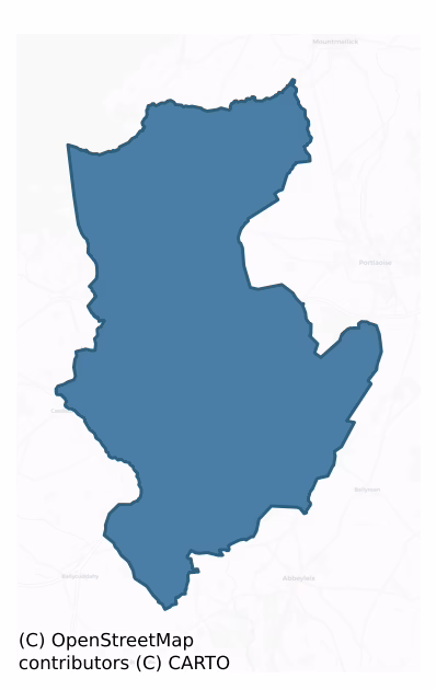
Maryborough West is a barony of County Laois, in the historical province of Leinster (Irish: Port Laoise Thiar), covering 170 km² of land. The barony records 100 NMS archaeological sites and 45 NIAH listed buildings, placing it at around the 2nd percentile among 280 ROI baronies for sites per km². This means it is in the bottom tenth of all baronies for sites per km². Dated archaeological evidence runs from the Middle-Late Bronze Age through to the Post Medieval, spanning 5 of 9 archaeological periods, placing the barony in the 8th percentile among 280 ROI baronies for chronological depth. This means it is in the bottom tenth of all baronies for chronological depth. The largest dated subset of recorded sites dates to the Early Medieval.

Heritage at a glance
Percentile rankings throughout this profile compare each barony only against the other 279 Republic of Ireland baronies.
The recorded heritage of Maryborough West
The National Monuments Service Sites and Monuments Record (SMR) is the statutory inventory of archaeological sites for the Republic of Ireland, maintained by the Department of Tourism, Culture, Arts, Gaeltacht, Sport and Media. Sites recorded here include earthworks, ringforts, megalithic tombs, ecclesiastical remains, and post-medieval features; not every record is legally protected, but each is registered as a monument of archaeological interest.
The National Monuments Service records 100 archaeological sites in Maryborough West, putting it at the 2nd percentile among 280 ROI baronies for sites per km². This means it is in the bottom tenth of all baronies for sites per km². A sparse recorded total of this kind in Ireland often reflects survey priority rather than genuine absence of past activity. Protection coverage is near-universal — 95 sites (95%) fall within a recorded monument protection zone, indicating an extensively surveyed landscape. The record is dominated by defensive sites — ringforts, enclosures, hillforts, and stone forts (40 sites, 40% of the total), with ecclesiastical sites forming a substantial secondary presence (34 sites, 34%). The most diagnostically specific type is Cross-slab (13 records, 13% of the barony's NMS total) — compared to an ROI average of 5% across all baronies where this type occurs. Cross-slab is a stone slab inscribed with a cross, used as a grave-marker or memorial, dated pre-1200 AD. The broader 'Enclosure' classification — which catches unclassified ringforts and field enclosures — accounts for a further 19 records (19%) and reflects the difficulty of sub-classifying degraded earthworks from surface evidence alone. Across the barony's 170 km², this gives a recorded density of 0.59 sites per km².
Most common monument types
Hover or tap a monument type to see its definition.
| Type | Count |
|---|---|
| Enclosure a banked or ditched feature of uncertain type, used as a catch-all where the original function cannot be determined from surface evidence | 19 |
| Cross-slab a stone slab inscribed with a cross, used as a grave-marker or memorial, dated pre-1200 AD | 13 |
| Ringfort – rath an earthen ringfort enclosed by a bank and external ditch — the most common Early Medieval farmstead, broadly dated 500–1000 AD | 10 |
| Church a building used for public Christian worship, of any date from c. 500 AD onwards | 7 |
| Graveyard a burial area associated with a church, in use from the medieval period onwards | 6 |
| Moated site | 5 |
| Ritual site – holy well a well or spring traditionally associated with a saint, often credited with healing properties; many trace earlier ritual origins but devotion is documented from the medieval period onwards | 3 |
| Ecclesiastical enclosure a large enclosure surrounding an Early Medieval church or monastery and its associated activity areas | 3 |
Chronological distribution
The dated archaeological record for Maryborough West spans from the Middle-Late Bronze Age through to the Post Medieval, with activity attested across 5 of 9 archaeological periods. This is the 8th percentile across ROI baronies — a relatively narrow chronological band, with much of Irish prehistory not represented in the dated record. Activity concentrates most heavily in the Early Medieval (34 sites, 43% of dated material), with the Iron Age forming a secondary peak (31 sites, 39%). A further 21 recorded sites (21% of the overall NMS register for the barony) carry no period attribution — appearing as 'Unknown' in the bar chart below. This typically reflects either records that pre-date the standardised period vocabulary or sites awaiting specialist dating review, rather than a genuine absence of chronological evidence.
Sample of recorded monuments
Show 25 sample monuments (of 100 total)
A representative sample of 25 recorded monuments drawn from the barony’s 100 total NMS entries. Sites within a recorded monument protection zone and rarer site types are prioritised so the list shows a meaningful cross-section rather than only the most common type. Each entry shows the official Sites and Monuments Record reference number and the description published by the National Monuments Service.
Designed landscape feature
Marked on the 1841 ed OS 6-inch map. No visible surface remains. Situated witnin Ballyfin estate, indicated on first edition of the OS 6-inch map as a landscape feature.
The above description is derived from the…
Marked on the 1841 ed OS 6-inch map. No visible surface remains. Situated witnin Ballyfin estate, indicated on first edition of the OS 6-inch map as a landscape feature.
The above description is derived from the published 'Archaeological Inventory of County Laois' (Dublin Stationery Office, 1995) compiled by P. David Sweetman, Olive Alcock and Bernie Moran. In certain instances the entries have been revised and updated in the light of recent research.
Date of upload: 17 December 2007
Children's burial ground
A subcircular enclosure (LA012-005—-) with a childrens burial ground in SW quadrant of interior. No evidence of original entrance. Uninscribed grave-markers in the SW corner indicate its use as a children's burial…
A subcircular enclosure (LA012-005—-) with a childrens burial ground in SW quadrant of interior. No evidence of original entrance. Uninscribed grave-markers in the SW corner indicate its use as a children's burial ground.
The above description is derived from the published 'Archaeological Inventory of County Laois' (Dublin Stationery Office, 1995) compiled by P. David Sweetman, Olive Alcock and Bernie Moran. In certain instances the entries have been revised and updated in the light of recent research.
Date of upload: 17 December 2007
Mill – unclassified
In undulating countryside, overlooking river. Not marked on the 1841 or 1909 eds OS 6-inch maps. Reference to corn-mills here on the Nore river (Carrigan 1905, vol. 2, 297). Standing remains of an 18th century mill. No…
In undulating countryside, overlooking river. Not marked on the 1841 or 1909 eds OS 6-inch maps. Reference to corn-mills here on the Nore river (Carrigan 1905, vol. 2, 297). Standing remains of an 18th century mill. No earlier remains visible.
The above description is derived from the published 'Archaeological Inventory of County Laois' (Dublin Stationery Office, 1995) compiled by P. David Sweetman, Olive Alcock and Bernie Moran. In certain instances the entries have been revised and updated in the light of recent research.
Date of upload: 17 December 2007
Architectural fragment
In an elevated area within graveyard. A block of sandstone decorated with Romanesque art was uncovered in 1988 during graveyard (LA017-003007-) clean-up scheme.
This sandstone slab (H 0.5m; Wth 0.26m; T 0.22m) is…
In an elevated area within graveyard. A block of sandstone decorated with Romanesque art was uncovered in 1988 during graveyard (LA017-003007-) clean-up scheme.
This sandstone slab (H 0.5m; Wth 0.26m; T 0.22m) is decorated with an incised double chevron running along the edge of the sandstone block, the space between the two opposed chevrons contains a floral motif. Probably the jambstone of a Romanesque doorway or archway very similar to the carvings found on the chancel arch of the Nuns chapel in Clonmacnoise. This block has been set into concrete against the inner face of the W wall of the graveyard to the N of the gateway into the graveyard.
The above description is derived from the published 'Archaeological Inventory of County Laois' (Dublin Stationery Office, 1995) compiled by P. David Sweetman, Olive Alcock and Bernie Moran. In certain instances the entries have been revised and updated in the light of recent research.
Date of upload: 17 December 2007
Castle – motte
Located i9n field immediately S of Clonenagh church (LA017-003001-) and graveyard (LA017-003002-). A circular platform (diam c. 23m, H c. 2.5m) with evidence of a surrounding fosse. No other visible surface…
Located i9n field immediately S of Clonenagh church (LA017-003001-) and graveyard (LA017-003002-). A circular platform (diam c. 23m, H c. 2.5m) with evidence of a surrounding fosse. No other visible surface remains.
The above description is derived from the published 'Archaeological Inventory of County Laois' (Dublin Stationery Office, 1995) compiled by P. David Sweetman, Olive Alcock and Bernie Moran. In certain instances the entries have been revised and updated in the light of recent research.
Date of upload: 17 December 2007
Font
Reference to a font here (Comerford 1886, vol. 3, 282). In gently undulating countryside. No visible surface remains. At Loughshinahawn there stood a Mass-house beside which there was a stone holy water stoup, used in…
Reference to a font here (Comerford 1886, vol. 3, 282). In gently undulating countryside. No visible surface remains. At Loughshinahawn there stood a Mass-house beside which there was a stone holy water stoup, used in this chapel which was to be seent here until quite recently (Comerford 1886, vol. 3, 282).
The above description is derived from the published 'Archaeological Inventory of County Laois' (Dublin Stationery Office, 1995) compiled by P. David Sweetman, Olive Alcock and Bernie Moran. In certain instances the entries have been revised and updated in the light of recent research.
Date of upload: 17 December 2007
Water mill – horizontal-wheeled
Reference to a horizontal watermill (NMI files). No visible remains.
The above description is derived from the published 'Archaeological Inventory of County Laois' (Dublin Stationery Office, 1995) compiled by P.…
Reference to a horizontal watermill (NMI files). No visible remains.
The above description is derived from the published 'Archaeological Inventory of County Laois' (Dublin Stationery Office, 1995) compiled by P. David Sweetman, Olive Alcock and Bernie Moran. In certain instances the entries have been revised and updated in the light of recent research.
Date of upload: 17 December 2007
Historic town
Situated on E side of the Mountrath River. Historic town that was established in 1620 when Emanuel Downing along with other English families mainly from Suffolk purchased the Lordship of Mountrath from a member of the…
Situated on E side of the Mountrath River. Historic town that was established in 1620 when Emanuel Downing along with other English families mainly from Suffolk purchased the Lordship of Mountrath from a member of the Cosby Family (SMR File, Loeber 17/03/1995). In 1628 Sir Charles Coote obtained a grant 'of two weekly markets and two fairs, and established a very extensive linen and fustian manufactory, which in the war of 1641, together with much of his other property here, was destroyed' (Lewis 1837, vol. 2, 395). In this granted he was licensed to hold 'a Tuesday and Saturday market, and two fairs, on the Thursday before the feasts of St. Philip and Jacob [May 3rd], and All Saints [November 1st]' (Lodge 1789, vol. 2, 65). In the 19th century fairs were held here on February 17th, May 8th, June 20th, August 10th, September 19th and November 6th (Lewis 1837, vol. 2, 396). By 1659 it was the largest and most important settlement in the county. Several buildings are marked on the Down Survey (1655-6) map. The outline of possible town defences (LA017-033004-) are visible on the E side of the town on a map of Mountrath drawn by Thomas Moland in 1730 (NLI n.3947, p.3618). On the W side of Shannon Street, a two storey house (LA017-033001-) with a massive chimney stack crowned by diagonally placed flues probably dates to the seventeenth century. The foundry house, formerly a Quaker's Meeting House, on W side of Bridge Street formerly known as Coote Street possibly incorporates a…
Castle – tower house
Marked on the 1563 map of Leix and Offaly (Hore 1863, f.p. 345). In a low-lying area beside river. Only featureless fragments of masonry remain. Described in 1958 OPW report as a castle which appears to be the remains…
Marked on the 1563 map of Leix and Offaly (Hore 1863, f.p. 345). In a low-lying area beside river. Only featureless fragments of masonry remain. Described in 1958 OPW report as a castle which appears to be the remains of a tower house. One wall stood to a considerable height till 22 or 23 years ago when it was blow up as being dangerous. It is said to have been inhabited until about the middle of the eighteenth century. Some cobbling was disclosed in the course of Land project works, presumably representing the yard.
The above description is derived from the published 'Archaeological Inventory of County Laois' (Dublin Stationery Office, 1995) compiled by P. David Sweetman, Olive Alcock and Bernie Moran. In certain instances the entries have been revised and updated in the light of recent research.
Date of upload: 17 December 2007
House – fortified house
Marked on the 1841 and 1909 eds OS 6-inch maps. No historical references known. On a ridge overlooking river to S. Ruins of a possible late medieval house, rectangular in shape (dims.8.7m NE-SW, 5.6m NW-SE) constructed…
Marked on the 1841 and 1909 eds OS 6-inch maps. No historical references known. On a ridge overlooking river to S. Ruins of a possible late medieval house, rectangular in shape (dims.8.7m NE-SW, 5.6m NW-SE) constructed with limestone rubble. Entrance at NE. Enclosed by a bawn wall (LA023-017002-) of limestone rubble with a slight base-batter.
The above description is derived from the published 'Archaeological Inventory of County Laois' (Dublin Stationery Office, 1995) compiled by P. David Sweetman, Olive Alcock and Bernie Moran. In certain instances the entries have been revised and updated in the light of recent research.
Date of upload: 17 December 2007
Bawn
Outlined on the 1839 and 1909 eds OS 6-inch maps. No historical references known. On a ridge overlooking river to South. Ruins of a possible medieval house (LA023-017001-), rectangular in shape constructed with…
Outlined on the 1839 and 1909 eds OS 6-inch maps. No historical references known. On a ridge overlooking river to South. Ruins of a possible medieval house (LA023-017001-), rectangular in shape constructed with limestone rubble. Entrance at North East. Enclosed by a bawn wall (L. c. 40m, H. c. 3.5m) of limestone rubble with a slight base batter.
The above description is derived from the published 'Archaeological Inventory of County Laois' (Dublin Stationery Office, 1995) compiled by P. David Sweetman, Olive Alcock and Bernie Moran. In certain instances the entries have been revised and updated in the light of recent research.
Date of upload: 17 December 2007
Hilltop enclosure
A circular enclosure (diam. c. 70m), on high ground overlooking surrounding area, defined by a bank of earth and stone (Wth c. 5.3m, ext. D c. 1.9m) and external fosse (Wth c. 7.7m, ext. D c. 0.9m). Now very degraded at…
A circular enclosure (diam. c. 70m), on high ground overlooking surrounding area, defined by a bank of earth and stone (Wth c. 5.3m, ext. D c. 1.9m) and external fosse (Wth c. 7.7m, ext. D c. 0.9m). Now very degraded at S. No evidence of original entrance.
The above description is derived from the published 'Archaeological Inventory of County Laois' (Dublin Stationery Office, 1995) compiled by P. David Sweetman, Olive Alcock and Bernie Moran. In certain instances the entries have been revised and updated in the light of recent research.
Date of upload: 17 December 2007
House – 16th/17th century
A 17th century town (LA017-033) that was flounded during the first quarter of the seventeenth century by Sir Charles Coote which he settled with Protestant families. In its early years the town was a centre for the…
A 17th century town (LA017-033) that was flounded during the first quarter of the seventeenth century by Sir Charles Coote which he settled with Protestant families. In its early years the town was a centre for the manufacture of linen and fustian, and an important centre of the Iron industry (Feehan 1983, 390). The Census of 1659 gives Mountrath a population of 223 families, 49 of which were English, the main landholders were Daniel Carroll, William Lockington, and Thomas Low. The town square is a trapezoidal shaped area, its centre was formerly occupied by an 18th century markethouse which also functioned as a courthouse and now has been replaced by a roundabout. Leading off to the south of the market square in Shannon Street. At its N end on the W side there is a two storey, probably 17th-century house with a massive chimney stack, crowned by diagonally placed flues, Internal features include running timber beams on both floors (Loeber 1995). This building was described by the National Inventory of Architectural Heritage in 2002 as a 'Terraced three-bay three-storey house, built c.1780, incorporating fabric of earlier building on site. Chimneystack with diagonally placed flues. Renovated, c.1985, with shopfront inserted to ground floor. Double-pitched roof with replacement fibre-cement tiles, roughcast chimneystacks and cast-iron rainwater goods' (NIAH 2002-).
Compiled by: Caimin O'Brien
Date of upload: 17 December 2007
Bridge
Spanning the River Nore with nearby castle (LA016-017001-) 150m to the SE and mill site (LA016-017002-) immediately to the N. This six-arch limestone bridge (road Wth 18m) with rubble limestone cutwaters, is a…
Spanning the River Nore with nearby castle (LA016-017001-) 150m to the SE and mill site (LA016-017002-) immediately to the N. This six-arch limestone bridge (road Wth 18m) with rubble limestone cutwaters, is a multi-period structure the earlier bridge is located on the upstream or W side. The arch rings (Wth 4.65m N-S; H 3.4m) on the upriver side consist of undressed roughly cut voussoirs while those on the downriver side consist of cut stone dressed wedge shaped voussoirs. On the underside of the bridge a straight joint is clearly visible where the bridge was widened by 9.1m in the 18th century. The earlier bridge measured 5.6m E-W wide on the underside of the arch, if this bridge had a parapet wall on either side thie original road over the bridge may have measured approx. 4m. The downstream or E face was added to the bridge in the 18th century possibly when the nearby Nore Flour Mills were constructed during this period (c. 1750) The earlier bridge appears to have been contemporary with the medieval castle that is located on the ridge looking down over the crossing point of the River Nore.
Compiled by: Caimin O'Brien
Date of upload: 17 December 2007
Meeting-house
A possible 17th century Quakers Meeting House is situated at the N end of Bridge Street formerly known as Coote Street on the W side of the road near the market square of the town of Mountrath. The foundry house,…
A possible 17th century Quakers Meeting House is situated at the N end of Bridge Street formerly known as Coote Street on the W side of the road near the market square of the town of Mountrath. The foundry house, formerly a Quaker's Meeting House possibly incorporates an earlier seventeenth century house (information from R. Loeber; SMR File 1995). This house was originally built c. 1715 by Gerhon Boat and today stands three storeys high with three gable fronted roofs which face onto Coote Street (info. R. Loeber 1995). This building was described by the National Inventory of Architectural Heritage in 2002 as a 'Detached five-bay three-storey triple gable-fronted house, dated 1713, with remains of shopfront to part ground floor. Renovated c.1997. Detached coach house, c.1715, to site. Triple gable-fronted slate roof with nap rendered chimneystacks with clay pots and cast-iron rainwater goods' (NIAH 2002-).
Compiled by Caimin O'Brien
Date of upload / revision: 17 August 2010
Town defences
A map of Mountrath (LA017-033) dating from 1730 shows the outline of possible defenses (LA017-033003-) on the east side of the town, a projecting line of boundary on the extreme E side of the town on the current edition…
A map of Mountrath (LA017-033) dating from 1730 shows the outline of possible defenses (LA017-033003-) on the east side of the town, a projecting line of boundary on the extreme E side of the town on the current edition of the OS 6-inch map may follow the original line of the town defences (SMR File R. Loeber 1995). On the current edition of the OS six-inch maps the property boundary at the rear of the houses facing onto the E side of the Main St. kicks out forming a triangular shaped projection similar to an earthen bastion. This projecting spur may following the original line of the town defences indicated on the map of Mountrath drawn by Thomas Moland in 1730 (NLI n.3947, p.3618). The Mountrath River appears to have formed the defensive element of the town on the S and E sides. The earthen defences of the town may have run off the N and S end of the Mountrath River forming a possible earthen enclosure around the town of Mountrath in the 17th century.
Compiled by Caimin O'Brien
Date of upload / revision : 17 August 2010
Bullaun stone
Situated in undulating countryside. Cremogue church and graveyard (LA017-014001/002-) located 180m to the N of the holy well (LA017-013—-) and bullaun stone. Holy well visited on St Fintan's feast day, the 17th of…
Situated in undulating countryside. Cremogue church and graveyard (LA017-014001/002-) located 180m to the N of the holy well (LA017-013—-) and bullaun stone. Holy well visited on St Fintan's feast day, the 17th of February. Pebbles from it are thought to act as preservatives against shipwreck or accidental death (Comerford 1886, vol. 3, 337). The bullaun stone is located beside the holy well on the edge of the watercourse running out of the well.
The above description is derived from the published 'Archaeological Inventory of County Laois' (Dublin Stationery Office, 1995) compiled by P. David Sweetman, Olive Alcock and Bernie Moran. In certain instances the entries have been revised and updated in the light of recent research.
Compiled by Caimin O'Brien
Date of upload: 04 May 2012
Castle – unclassified
Ballyfin Castle was built by the Crosbies during the reign of Elizabeth I (1558-1603). Granted to Piriam Pole in 1666, it was later demolished by his son William Pole who built a house on the site (Comerford 1883-86,…
Ballyfin Castle was built by the Crosbies during the reign of Elizabeth I (1558-1603). Granted to Piriam Pole in 1666, it was later demolished by his son William Pole who built a house on the site (Comerford 1883-86, 136-137). The present house was built between 1821 and 1826 (Bence-Jones 1978, 21). Building indicated on 1563 map of Leix and Offaly. On the same map the castle or house of Ballyfin is indicated (O'Flanagan 1933 vol. 2, 35). No surface remains visible.
The above description is derived from the published 'Archaeological Inventory of County Laois' (Dublin Stationery Office, 1995) compiled by P. David Sweetman, Olive Alcock and Bernie Moran. In certain instances the entries have been revised and updated in the light of recent research.
Date of upload: 17 December 2007
Castle – unclassified
In undulating countryside. A Fitzpatrick castle built in the sixteenth century inside a large circular earthwork (LA017-002002-) known as Red Castle Fort (O'Byrne 1856, 73; O'Hanlon & O'Leary 1907, vol. 1, 210). No…
In undulating countryside. A Fitzpatrick castle built in the sixteenth century inside a large circular earthwork (LA017-002002-) known as Red Castle Fort (O'Byrne 1856, 73; O'Hanlon & O'Leary 1907, vol. 1, 210). No visible surface remains. According to local tradition the castle was approached by a laneway known as Cromwell's Road, believed to mark the line of Cromwell's march from Portlaoise to Birr, there are now no traces of building or stonework of any kind and the only remains are those of earthworks, circular in shape and resembling an immense rath (LA017-002002-). On the first edition of the OS 6-inch map the castle is depicted as a castle in ruins and shown as a building aligned on a N-S axis standing on the SE quadrant of the Red Castle Fort (LA017-002002-). On this 6-inch map the building depicted as 'Castle in ruins' is enclosed by a stone wall which forms an L-shaped area to the N, E and S of this building which may represent the remains of a bawn wall associated with the castle ruins. On digital globe aerial photographs the outline of these levelled walls can still be seen. On the first edition OS 6-inch map a well is depicted a short distance to the S of the castle ruins. On subsequent editions of the OS maps the castle site is depicted incorrectly as situated in the west quadrant of the enclosure (LA017-002002-). In the early 1900s a small single storey cottage was built on the site of the castle ruins.
In the S quadrant of the enclosure known as…
Ritual site – holy tree/bush
In an elevated area beside the road. An ash tree containing water which is said to have healing powers (O'Hanlon and O'Leary 1907, 200-209). According to Comerford an old tree, opposite the well (LA017-003003-), is…
In an elevated area beside the road. An ash tree containing water which is said to have healing powers (O'Hanlon and O'Leary 1907, 200-209). According to Comerford an old tree, opposite the well (LA017-003003-), is popularly supposed to be connected with it. In some cavities in the trunk, water is said to be at all times found, in which healing properties are ascribed (Comerford 1886, vol. 3, 298).
The above description is derived from the published 'Archaeological Inventory of County Laois' (Dublin Stationery Office, 1995) compiled by P. David Sweetman, Olive Alcock and Bernie Moran. In certain instances the entries have been revised and updated in the light of recent research.
Date of upload: 17 December 2007
Ritual site – holy tree/bush
Marked as 'thorn' on the 1838 ed OS 6-inch map. A hawthorn bush visible in this area associated with site of church (LA017-004001-) and ecclesiastical enclosure (LA017-004002-).
The above description is derived from…
Marked as 'thorn' on the 1838 ed OS 6-inch map. A hawthorn bush visible in this area associated with site of church (LA017-004001-) and ecclesiastical enclosure (LA017-004002-).
The above description is derived from the published 'Archaeological Inventory of County Laois' (Dublin Stationery Office, 1995) compiled by P. David Sweetman, Olive Alcock and Bernie Moran. In certain instances the entries have been revised and updated in the light of recent research.
Date of upload: 17 December 2007
Field system
Field system visible on aerial photographs (GSI, S 226-7) taken in June 1973. Field system appears to radiate out from oval-shaped enclosure (LA017-018001-) creatong small square-shaped fields on S side of enclosure. …
Field system visible on aerial photographs (GSI, S 226-7) taken in June 1973. Field system appears to radiate out from oval-shaped enclosure (LA017-018001-) creatong small square-shaped fields on S side of enclosure. Field system clearly visible on Digital Globe aerial photographs. No visible surface remains.
The above description is derived from the published 'Archaeological Inventory of County Laois' (Dublin Stationery Office, 1995) compiled by P. David Sweetman, Olive Alcock and Bernie Moran. In certain instances the entries have been revised and updated in the light of recent research.
Compiled by: David Sweetman & Bernie Moran
Revised by: Caimin O'Brien
Date of revised upload: 13 June 2016
Burial ground
Not marked on the 1841 or 1909 editions of the OS 6-inch maps. In a low-lying area beside river.
Human bones discovered here in 1958. No visible surface remains. The bones were found about 100 yards S of the castle…
Not marked on the 1841 or 1909 editions of the OS 6-inch maps. In a low-lying area beside river.
Human bones discovered here in 1958. No visible surface remains. The bones were found about 100 yards S of the castle (LA023-012001-) in the same field. According to the OPW report these bones did not represent burials and probably came from the old burial ground at Killeany which was partly destroyed by building a road through it over a 100 years ago (OPW 1958). Originally a graveyard nearby but the Grand Jury constructed a road through it before 1839 (OPW file 1958).
The above description is derived from the published 'Archaeological Inventory of County Laois' (Dublin Stationery Office, 1995) compiled by P. David Sweetman, Olive Alcock and Bernie Moran. In certain instances the entries have been revised and updated in the light of recent research.
Date of upload: 17 December 2007
Ring-ditch
Aerial photograph (GB90.CJ.13) shows cropmark of a ring-ditch; one of two ring-ditches (LA023-063) in close proximity. First recorded as a positive cropmark in July 1990. Plough-levelled rectilinear field system…
Aerial photograph (GB90.CJ.13) shows cropmark of a ring-ditch; one of two ring-ditches (LA023-063) in close proximity. First recorded as a positive cropmark in July 1990. Plough-levelled rectilinear field system (LA023-064) adjacent to the ring-ditches, but date uncertain (not on first edition of the OS 6-inch map).
The above report has been compiled by Dr. G.F. Barrett and supplied to the Archaeological Survey of Ireland.
Date of this report: 21 January 2010
Compiled by Caimin O'Brien
Date of upload: 13 August 2010
Enclosure
An oval-shaped enclosure located in the centre of a sub-triangular shaped field is visible on aerial photographs (GSI, S 226-7) taken in June, 1973. Digital Globe aerial photographs shows curving enclosing element from…
An oval-shaped enclosure located in the centre of a sub-triangular shaped field is visible on aerial photographs (GSI, S 226-7) taken in June, 1973. Digital Globe aerial photographs shows curving enclosing element from E-S-SW. No visible surface remains. Possible field system (LA017-008002-) radiates out from enclosure from E-S-W. This field system is clearly visible on Digital Globe aerial photographs.
The above description is derived from the published 'Archaeological Inventory of County Laois' (Dublin Stationery Office, 1995) compiled by P. David Sweetman, Olive Alcock and Bernie Moran. In certain instances the entries have been revised and updated in the light of recent research.
Compiled by: David Sweetman & Bernie Moran
Revised by: Caimin O'Brien
Date of revised upload: 13 June 2016
Listed buildings
The National Inventory of Architectural Heritage (NIAH) is a state survey appraising buildings of architectural, historical, archaeological, artistic, cultural, scientific, social, or technical interest. Each surveyed structure receives a rating from International (the highest, for buildings of European importance) through National, Regional, Local, and Record-Only.
The NIAH records 45 listed buildings in Maryborough West (22nd percentile across ROI baronies). The highest-graded structures include 2 of National significance. The Republic holds 937 National-graded buildings in total, so this barony accounts for around 0% of the national total. Construction dates concentrate most heavily in the Victorian (1830-1900) period. The most-recorded building type is house (10 examples, 22% of the listed stock).
Terrain and environment
Mean elevation across the barony is 116m — the 70th percentile among 280 ROI baronies for elevation. This means it is in the top third of all baronies for elevation. Elevation matters for heritage because higher-altitude baronies typically favour defensive monuments — ringforts and hilltop forts placed on prominent ground — while lowland baronies are more likely to carry the dense settlement and church networks of intensive agricultural landscapes. A maximum elevation of 307m gives the barony meaningful vertical relief. Mean slope is 2.3° — the 20th percentile among 280 ROI baronies for slope. This means it is in the bottom third of all baronies for slope. This is broadly flat terrain, the kind of landscape best suited to intensive agriculture. Slope is a key control on both land use and archaeological preservation: steep ground resists ploughing and tends to preserve earthworks intact, while gentle slopes favour intensive cultivation that damages or destroys surface archaeology over time. The Topographic Wetness Index averages 11.6, the 82nd percentile among 280 ROI baronies for wetness. This means it is in the top fifth of all baronies for wetness. This is wet, slow-draining ground by ROI standards — the kind of landscape that may carry waterlogged archaeological sites of unusual preservation value. Drainage matters for heritage because poorly-drained ground preserves organic archaeology (wooden trackways, leather, textiles, and on rare occasions human remains) far better than free-draining soil; well-drained ground favours arable use but destroys organic material rapidly. The land cover is dominated by improved grassland (78%) and woodland (16%).
Terrain measurements
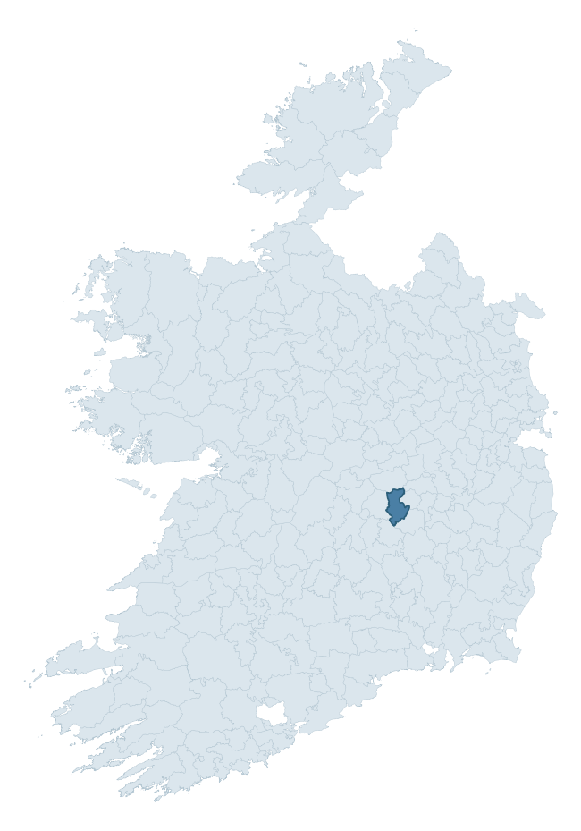
Where this barony sits in the Republic of Ireland
Geology and preservation
Bedrock geology shapes the landscape long before any settlement begins — controlling soil drainage, agricultural potential, the survival of upstanding monuments, and the preservation of buried archaeology. The figures below come from the Geological Survey Ireland 1:100,000 bedrock map.
The bedrock underlying Maryborough West is predominantly limestone (70% of the barony by area), laid down during the Carboniferous period (84% by area, around 359 to 299 million years ago). Limestone is the most heritage-rich bedrock in Ireland. It supports fertile, well-drained soils that favoured dense Early Medieval settlement and Norman manorial agriculture, and it weathers into karst features — sinkholes, caves, swallow holes, and souterrains — that frequently carry archaeology. Where peat overlies limestone, organic preservation can be exceptional. The single largest mapped unit is the Ballysteen Formation (52% of the barony's bedrock).
Rock type composition
Largest mapped unit: Ballysteen Formation (52% of the barony)
Placename evidence
Logainm records 7 heritage-diagnostic placenames for Maryborough West, a modest sample drawn predominantly from the townland record. The dominant stratum is early christian ecclesiastical. The most frequent diagnostic roots are ráth- (2) and cill- (2). With a sample of this size the count should be treated as indicative rather than definitive.
Pre-Christian / Early Medieval Defensive
| Root | Count | Meaning |
|---|---|---|
| ráth- | 2 | earthen ringfort |
| dún- | 1 | hilltop or promontory fort |
Early Christian Ecclesiastical
| Root | Count | Meaning |
|---|---|---|
| cill- | 2 | church (early) |
| mainistir- | 1 | monastery |
| díseart- | 1 | hermitage |
Other baronies in Laois
About this profile
Click any section below to expand.
What is a barony?
A barony is a historic administrative unit in Ireland, broadly equivalent to an English hundred. The 280 baronies used here are from the OSi 2019 National Statutory Boundaries (generalised 20m), covering the 26 counties of the Republic of Ireland. Baronies derive from the Norman period, were formalised in the 17th century, and have not been redrawn for statistical purposes. They vary enormously in area, from compact urban baronies in Dublin to vast upland baronies in Connacht, and should not be compared by raw site count without accounting for area differences.
What counts as a site?
This profile combines three distinct heritage registers, each with its own definition of what constitutes a recordable site:
- Archaeological sites (NMS). The National Monuments Service Sites and Monuments Record (SMR) catalogues every known archaeological monument or site of archaeological interest in the Republic, from prehistoric burial mounds and ringforts to medieval churches and post-medieval defensive works. Inclusion does not require legal protection — only that the site has been identified, surveyed, and assessed as having archaeological value. A separate subset of these sites lies within a recorded protection zone, which gives them statutory protection under the National Monuments Acts.
- Listed buildings (NIAH). The National Inventory of Architectural Heritage records buildings of architectural, historical, archaeological, artistic, cultural, scientific, social, or technical interest. Each surveyed structure is appraised on a five-tier scale: International, National, Regional, Local, and Record-Only. The NIAH appraisal is informational rather than strictly statutory, but it underpins local-authority Record of Protected Structures (RPS) listings.
- Heritage placenames (Logainm). Logainm is the authoritative database of Irish placenames maintained by the Placenames Branch. This profile applies a heritage-diagnostic classifier to the Irish-language form of each townland name, flagging roots that signal defensive sites (ráth-, lios-, dún-, caiseal-, cathair-), ecclesiastical foundations (cill-, teampall-, domhnach-, mainistir-), prehistoric burial-ritual features (tuaim-, carn-, leaba-), or Norse-contact settlement (gall-). Townlands without one of these diagnostic roots are not flagged here — they may still carry historical significance, but that significance is not encoded in the name itself.
Editorial principles
The narrative sections of this profile follow several explicit principles:
- Evidential. Every claim about this barony’s heritage character is anchored in the underlying register data. Where a site count, a placename count, or a percentile rank is cited, it is computed from the source datasets at export time, not estimated.
- Comparative. Counts and metrics are reported alongside their percentile rank against the other 279 ROI baronies. A barony with 50 ringforts in absolute terms could be unusually high or unusually low depending on its size and regional context; percentile ranking removes that ambiguity.
- Transparent on limits. Where a register has known coverage gaps, survey biases, or data-quality issues that affect this barony’s figures, the profile flags them rather than presenting the numbers as definitive.
- No interpretation beyond what the data supports. The narrative does not speculate about historical events, social dynamics, or cultural meaning beyond what the recorded heritage and placename evidence directly attests.
Data caveats and limits
- NMS Sites and Monuments Record is the product of survey campaigns conducted at different intensities across different counties and decades. Some baronies have been surveyed more thoroughly than others, and absolute counts should be read in that light. Sites destroyed by development before survey are typically not represented; sites in heavily forested or upland terrain are sometimes under-recorded.
- NIAH coverage is broadly complete for the Republic of Ireland but the survey was conducted on a rolling county-by-county basis, and the most recent appraisal date varies. Buildings demolished or substantially altered after their original survey may still appear in the register; conversely, recent buildings of merit may not yet have been appraised.
- Logainm classification applies a deliberately conservative pattern-matching approach to the Irish-language townland forms. The classifier prioritises true positives over recall: a townland may carry a heritage signal that the classifier doesn’t recognise, particularly where the diagnostic root has been heavily anglicised or where the townland name draws on a less common term. The 60,000+ townland records and ~9,800 classified placenames give a substantial signal at barony scale, but individual townland names should be checked against Logainm directly for definitive interpretation.
- Period attribution. The chronological distribution reflects only those NMS sites that carry a recognised period attribution in the source data. Sites listed as “Unknown” period are excluded from the dated subset.
- Boundary changes. Some baronies have undergone minor boundary adjustments since their 19th-century definition; the OSi 2019 generalised boundaries used here are the current statutory definition and may differ slightly from historical maps in border areas.
- Bedrock geology is mapped at 1:100,000 scale, which means local variation within a barony — small pockets of different rock type, mineral veins, alluvium overlying bedrock — is generalised. The dominant-system and rocktype figures are area-weighted, so a barony reading “70% Carboniferous limestone” may still contain small but archaeologically important pockets of older or younger rock. Around 3% of GSI polygons do not match the lexicon and contribute no rocktype or system attribution.
Data sources
- National Monuments Service — Sites and Monuments Record (SMR) https://data.gov.ie/dataset/national-monuments-service-archaeological-survey-of-ireland
- National Inventory of Architectural Heritage (NIAH) https://data.gov.ie/dataset/national-inventory-of-architectural-heritage-niah-national-dataset
- Logainm — Placenames Database of Ireland https://www.logainm.ie/
- Ordnance Survey Ireland — National Statutory Barony Boundaries 2019 https://data-osi.opendata.arcgis.com/
- EURODEM — European Digital Elevation Model https://www.mapsforeurope.org/datasets/euro-dem
- ESA WorldCover https://esa-worldcover.org/en
- Geological Survey Ireland — 1:100,000 Bedrock Geology https://www.gsi.ie/en-ie/data-and-maps/Pages/Bedrock.aspx
Explore more: Search any of the 280 ROI baronies, browse by historical province, or read the methodology and data sources for the full Republic of Ireland Heritage Tool.