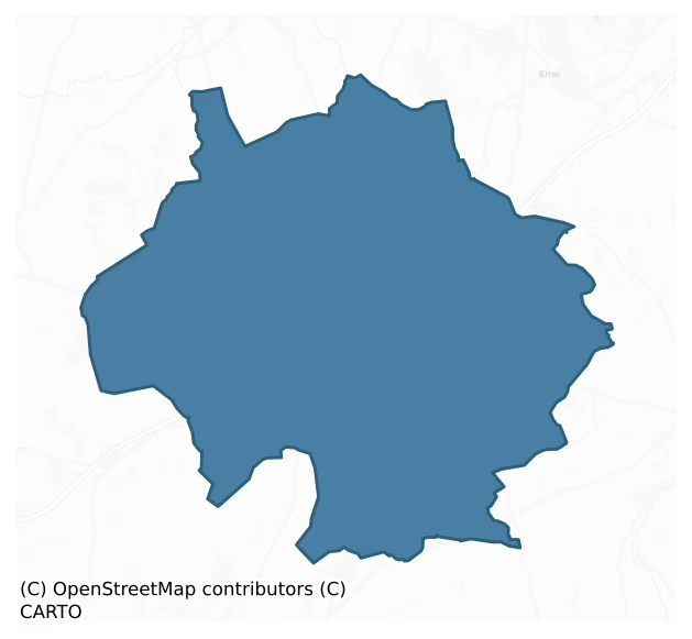
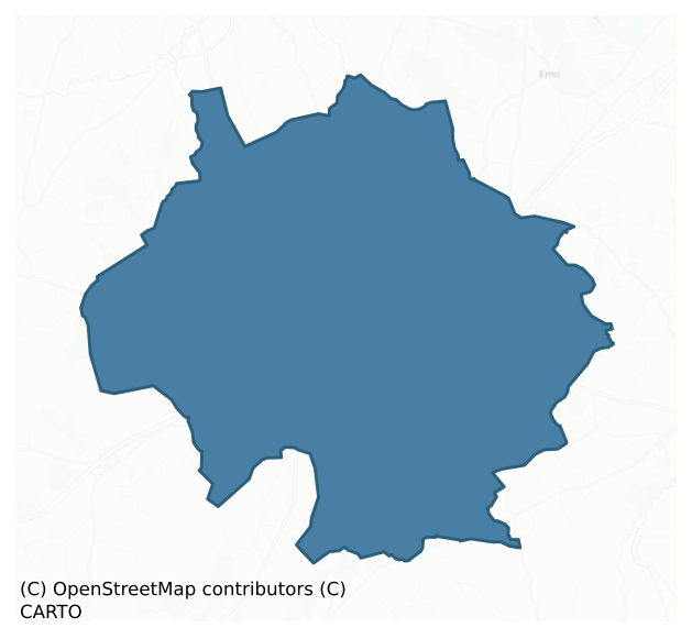
Maryborough East is a barony of County Laois, in the historical province of Leinster (Irish: Port Laoise Thoir), covering 102 km² of land. The barony records 129 NMS archaeological sites and 199 NIAH listed buildings, placing it at around the 21st percentile among 280 ROI baronies for sites per km². This means it is in the bottom third of all baronies for sites per km². Dated archaeological evidence runs from the Early Bronze Age through to the Post Medieval, spanning 6 of 9 archaeological periods, placing the barony in the 14th percentile among 280 ROI baronies for chronological depth. This means it is in the bottom fifth of all baronies for chronological depth. The largest dated subset of recorded sites dates to the Iron Age.
Heritage at a glance
Percentile rankings throughout this profile compare each barony only against the other 279 Republic of Ireland baronies.
The recorded heritage of Maryborough East
The National Monuments Service Sites and Monuments Record (SMR) is the statutory inventory of archaeological sites for the Republic of Ireland, maintained by the Department of Tourism, Culture, Arts, Gaeltacht, Sport and Media. Sites recorded here include earthworks, ringforts, megalithic tombs, ecclesiastical remains, and post-medieval features; not every record is legally protected, but each is registered as a monument of archaeological interest.
The National Monuments Service records 129 archaeological sites in Maryborough East, putting it at the 21st percentile among 280 ROI baronies for sites per km². This means it is in the bottom third of all baronies for sites per km². Of these, 112 (87%) fall within a recorded monument protection zone. The record is dominated by defensive sites — ringforts, enclosures, hillforts, and stone forts (55 sites, 43% of the total), with burial and ritual monuments forming a substantial secondary presence (32 sites, 25%). The most diagnostically specific type is Ringfort – rath (14 records, 11% of the barony's NMS total) — compared to an ROI average of 20% across all baronies where this type occurs. Ringfort – rath is an earthen ringfort enclosed by a bank and external ditch — the most common Early Medieval farmstead, broadly dated 500–1000 AD. The broader 'Enclosure' classification — which catches unclassified ringforts and field enclosures — accounts for a further 27 records (21%) and reflects the difficulty of sub-classifying degraded earthworks from surface evidence alone. Across the barony's 102 km², this gives a recorded density of 1.27 sites per km².
Most common monument types
Hover or tap a monument type to see its definition.
| Type | Count |
|---|---|
| Enclosure a banked or ditched feature of uncertain type, used as a catch-all where the original function cannot be determined from surface evidence | 27 |
| Ringfort – rath an earthen ringfort enclosed by a bank and external ditch — the most common Early Medieval farmstead, broadly dated 500–1000 AD | 14 |
| Barrow – ring-barrow a Bronze/Iron Age burial monument: a low circular area enclosed by ditch and outer bank | 10 |
| Church a building used for public Christian worship, of any date from c. 500 AD onwards | 8 |
| Burial an isolated interment of human or animal remains, not associated with a formal burial ground | 7 |
| Graveyard a burial area associated with a church, in use from the medieval period onwards | 7 |
| Barrow – unclassified a prehistoric burial mound where the specific barrow type cannot be determined from surface evidence | 5 |
| Castle – tower house a fortified residential tower of four or five storeys, mostly built by lords in the 15th and 16th centuries and often within a defended bawn | 4 |
Chronological distribution
The dated archaeological record for Maryborough East spans from the Early Bronze Age through to the Post Medieval, with activity attested across 6 of 9 archaeological periods. This is the 14th percentile across ROI baronies — a relatively narrow chronological band, with much of Irish prehistory not represented in the dated record. Every period from earliest to latest is represented in the record — an unbroken sequence of dated activity across the full chronological span. Activity concentrates most heavily in the Iron Age (39 sites, 39% of dated material), with the Early Medieval forming a secondary peak (25 sites, 25%). A further 29 recorded sites (22% of the overall NMS register for the barony) carry no period attribution — appearing as 'Unknown' in the bar chart below. This typically reflects either records that pre-date the standardised period vocabulary or sites awaiting specialist dating review, rather than a genuine absence of chronological evidence.
Sample of recorded monuments
Show 25 sample monuments (of 129 total)
A representative sample of 25 recorded monuments drawn from the barony’s 129 total NMS entries. Sites within a recorded monument protection zone and rarer site types are prioritised so the list shows a meaningful cross-section rather than only the most common type. Each entry shows the official Sites and Monuments Record reference number and the description published by the National Monuments Service.
Sheela-na-gig
Situated on the summit of a hill is a stone-walled garden whose NW angle has a distinct batter and projects forward from the line of the garden.This section of masonry (3.80m E-W, 3.90m N-S, H 2.80m) is built with…
Situated on the summit of a hill is a stone-walled garden whose NW angle has a distinct batter and projects forward from the line of the garden.This section of masonry (3.80m E-W, 3.90m N-S, H 2.80m) is built with roughly coursed limestone blocks and appears to be part of a castle, probably a tower house (LA008-013001-) (JKAS 1909, Vol. VI, 68) which is said to have been destroyed in 1650. Sheela-na-Gig thought to have come from here (Guest 1936, 117) location not now known. In the Ordnance Survey Letters of Tipperary, John O’Donovan wrote ‘that there was another figure of a similar hideous character on the old Castle of Shane (LA008-013001-) in the Queen’s County – a building erected by the O’Mores of Leix about the beginning of the reign of Queen Elizabeth’ (O’Flanagan 1930, vol. 1, part 2, 121). However in the Ordnance Survey Letters of County Laois, O’Donovan wrote that he ‘had no time to go to Shane Hill when I was in the Parish, to ascertain whether any of the castle remains or not. I have been informed, however, by a creditworthy man, that no part of it exists’ (O’Flanagan 1933, 64).
The above description is derived from the published 'Archaeological Inventory of County Laois' (Dublin Stationery Office, 1995) compiled by P. David Sweetman, Olive Alcock and Bernie Moran. In certain instances the entries have been revised and updated in the light of recent research.
Compiled by: Caimin O'Brien
Date of upload/revision: 23 May 2012
Castle – motte and bailey
Situated on a low hill, site consists of an oval-shaped motte (max. summit diam. 10m max.; base diam. c. 21m; H c. 5.4m) in NE section of bailey (dims. 50m E-W x 90m N-S) and seperated from it by a wide shallow fosse…
Situated on a low hill, site consists of an oval-shaped motte (max. summit diam. 10m max.; base diam. c. 21m; H c. 5.4m) in NE section of bailey (dims. 50m E-W x 90m N-S) and seperated from it by a wide shallow fosse (Wth c. 5.2m; D c. 1m). The bailey, which is probably the remains of an earlier ringfort (LA013-004002-) is defined by a low bank; intervening fosse (Wth c. 2.6m) with stone causeway (Wth c. 3m) and external bank (Wth c. 5.5m; int. H 1.3m; ext. H 1.4m) except at N. The bailey, which is probably the remains of an earlier ringfort that was re-fortified and converted into a motte and Bailey by the Anglo-Normans. Reference to a fort with deep fosses and level interior here (O'Hanlon and O'Leary 1907, vol. 1, 193).
The above description is derived from the published 'Archaeological Inventory of County Laois' (Dublin Stationery Office, 1995) compiled by P. David Sweetman, Olive Alcock and Bernie Moran. In certain instances the entries have been revised and updated in the light of recent research.
Date of upload: 17 December 2007
Burial mound
This was the site of a burial mound that when it was being levelled as part of land reclamation revealed several human skeletons (LA013-027001-). No surface remains of the burial mound survive, site is now a gravel…
This was the site of a burial mound that when it was being levelled as part of land reclamation revealed several human skeletons (LA013-027001-). No surface remains of the burial mound survive, site is now a gravel pit.
The above description is derived from the published 'Archaeological Inventory of County Laois' (Dublin Stationery Office, 1995) compiled by P. David Sweetman, Olive Alcock and Bernie Moran. In certain instances the entries have been revised and updated in the light of recent research.
Date of upload: 17 December 2007
Historic town
In 1556 the Laois 'campa', known to the English as 'Fort Protector' (LA013-041001-) or the Fort of Leix', was renamed Maryborough in honour of Queen Mary. The fort attracted settlers and a map of about 1560 shows a…
In 1556 the Laois 'campa', known to the English as 'Fort Protector' (LA013-041001-) or the Fort of Leix', was renamed Maryborough in honour of Queen Mary. The fort attracted settlers and a map of about 1560 shows a small walled town around the fort at that date. Maryborough was granted a market in 1567, borough in 1569 and was incorporated by charter of Elizabeth I in 1570 (Bradley et al. 1986, 49). The medieval town consists of a walled town (LA013-041006-) enclosing a large settlement with a plantation castle (LA013-041001-) in the centre and a circular tower or castle (LA013-041003-) of sixteenth century date , a church (LA013-041002-) and graveyard (LA013-041004-) and a mill (LA013-041005-). Many settlers moved into the town and the Elizabethan fiants record a particularly high number of property grants between 1569 and 1571. In 1635 the town obtained a grant of two fairs from Charles I and in 1646 the town was captured by Owen Roe O'Neill but was subsequently retaken by Lord Castlehaven (Bradley et al. 1986, 49). The original market place was probably in Main street in the area between the south side of the street and the fort (LA013-041001-) if one is to judge from the map of 1721. The late medieval church and graveyard was located outside the plantation fort (LA013-041001-) to the west. The map of c. 1560 shows 14 houses and are depicted as gabled single floor structures with a loft on the first floor; all have a central heart. Nothing remains of these houses today…
Castle – Anglo-Norman masonry castle
National Monument No. 615. Known as Dun Masc, the fort of Masc, from Masg, son of Augen Urgruidh, 4th son of Sedha Sithbhaic King of Leinster. It was the stronghold of the O'Mores, Kings of Leix. In 1170 Diarmait…
National Monument No. 615. Known as Dun Masc, the fort of Masc, from Masg, son of Augen Urgruidh, 4th son of Sedha Sithbhaic King of Leinster. It was the stronghold of the O'Mores, Kings of Leix. In 1170 Diarmait MacMurchada gave it to Strongbow, as part of his daughter Aoife's dower and it passed to Roger de Mortimer inthe partition of Leinster in 1247. In 1609 it was granted to Donat O'Brien, earl of Thomond. In 1641 it was taken by Sir Charles Coote but it was recaptured by Eoin Rua O'Neill in 1646. It was dismantled by the Cromwellian generals Hewson and Reynolds in 1650. Sir John Parnell constructed banqueting halls and other buildings here in 1795 (O'Leary 1909-11, 161).
Leask states that the castle was built c.1250 by William de Braose, however he had been dead since 1247, when the Marshall lordship was partitioned (Bradley et. al. 1986, 25). An inquisition of De Mortimers lands in 1323 found that the castle had been burned by the Irish, and in 1342, on the death of Laoighseach O Mordha it was recorded that he had destroyed the castrum nobile de Dunmaske and usurped De Mortimers power (O'Leary 1909-11, 165). Dunamase castle is specifically mentioned in the 1538 submission of Piers Mac Maolsheachlainn O Mordha which he made as part of the policy of surrender and regrant (Bradley et. al. 1986, 25). The castle is co-extensive with the rock outcrop and it consists of a Keep with an inner ward, a middle ward with a sallyport in SE side of the curtain wall and a twin-to…
Round tower
Early Christian church associated with Aonghas of Tallaght who gave his name to this foundation known as Díseart Aonghasa anglicised as Dysart Enos. Aonghas was a ninth century bishop who died c. 830 and was author of…
Early Christian church associated with Aonghas of Tallaght who gave his name to this foundation known as Díseart Aonghasa anglicised as Dysart Enos. Aonghas was a ninth century bishop who died c. 830 and was author of Féilire Aonghasa (Martyrology of Aonghas) which was reputedly started at his church in Dysart and finished in the monastery of Tallaght, Co. Dublin (Ó Riain 2011, 79). Unlocated round tower inside or in close proximity to the graveyard (LA013-059003-) at Dysart. In 1792 Daniel Beaufort (1792, 139-40) wrote that in Dysart were the remains of a round tower which the author had seen at this time. It has been suggested that Beaufort mistakenly identified the square tower on the W end of Dysart church (LA013-059001-) for a round tower (SMR file). This seems unlikely as the identification of the round tower was based on a personal visit to the site by Daniel Beaufort in 1792. The precise location of this possible round tower in the townland of Dysart has not been identified.
The above description is derived from the published 'Archaeological Inventory of County Laois' (Dublin Stationery Office, 1995) compiled by P. David Sweetman, Olive Alcock and Bernie Moran. In certain instances the entries have been revised and updated in the light of recent research.
Compiled and revised by: Caimin O'Brien
Date of revision: 2 October 2014
Hermitage
Early Christian church associated with Aonghas of Tallaght who gave his name to this foundation known as Díseart Aonghasa anglicised as Dysart Enos. Aonghas was a ninth century bishop who died c. 830 and was author of…
Early Christian church associated with Aonghas of Tallaght who gave his name to this foundation known as Díseart Aonghasa anglicised as Dysart Enos. Aonghas was a ninth century bishop who died c. 830 and was author of Féilire Aonghasa (Martyrology of Aonghas) which was reputedly started at his church in Dysart and finished in the monastery of Tallaght, Co. Dublin (Ó Riain 2011, 79). No visible surface remains inside Dysart graveyard (LA013-059003-) of any hermitage associated with Aonghas.
The above description is derived from the published 'Archaeological Inventory of County Laois' (Dublin Stationery Office, 1995) compiled by P. David Sweetman, Olive Alcock and Bernie Moran. In certain instances the entries have been revised and updated in the light of recent research.
Compiled and revised by: Caimin O'Brien
Date of revision: 2 October 2014
Earthwork
Situated atop a natural gravel ridge with good views in all directions. Piggott's castle (LA013-061001-) 390m to N amd Dysart church (LA013-059001-) and graveyard (LA013-059003-) 210m to WSW. Depicted as a small…
Situated atop a natural gravel ridge with good views in all directions. Piggott's castle (LA013-061001-) 390m to N amd Dysart church (LA013-059001-) and graveyard (LA013-059003-) 210m to WSW. Depicted as a small circular-shaped earthwork (approx. diam. c. 28m) and annotated as 'Fair Green' on the 1838 ed. OS 6-inch map. Depicted as a circular earthwork on the current ed. OS 6-inch map. No surface remains visible in field where 'Fair Green' and earthwork is marked on 1838 ed. OS 6-inch map. This earthwork acted as the focus point for the Fair Green of Dysart Enos and may represent the remains of an Anglo-Norman earthwork such as a motte or ringwork associated with nearby church and graveyard although this is uncertain. Fairs used to be held at this location on Whit-Monday, and on the 12th of October (O'Hanlon and O'Leary 1907, 231).
Compiled by and revised by: Caimin O'Brien
Date of revision: 2 October 2014
Bawn
Marked on the 1841 edition of the OS 6-inch map; a rectangular enclosure (max. dims. c. 50m N-S, 30m E-W) cut by an internal wall at ENE and WNW. No visible surface remains. 'Pigott's Castle' (LA013-061001-) lies on the…
Marked on the 1841 edition of the OS 6-inch map; a rectangular enclosure (max. dims. c. 50m N-S, 30m E-W) cut by an internal wall at ENE and WNW. No visible surface remains. 'Pigott's Castle' (LA013-061001-) lies on the line of the site at WNW.
The above description is derived from the published 'Archaeological Inventory of County Laois' (Dublin Stationery Office, 1995) compiled by P. David Sweetman, Olive Alcock and Bernie Moran. In certain instances the entries have been revised and updated in the light of recent research.
Date of upload: 17 December 2007
Cist
Discovered in 1845 in a 'Danish Rath' (LA013-062001-) was a cist containing an inhumed burial and two food vessels. Now in the National Museum (Bradley et. al. 1986, 22).
The above description is derived from the…
Discovered in 1845 in a 'Danish Rath' (LA013-062001-) was a cist containing an inhumed burial and two food vessels. Now in the National Museum (Bradley et. al. 1986, 22).
The above description is derived from the published 'Archaeological Inventory of County Laois' (Dublin Stationery Office, 1995) compiled by P. David Sweetman, Olive Alcock and Bernie Moran. In certain instances the entries have been revised and updated in the light of recent research.
Date of upload: 17 December 2007
Kiln – lime
The earthwork indicated on the 1838 edition of the OS 6-inch map is a cliff-edge face or quarry face associated with a lime kiln that is indicated on this edition of the map. The lime-kiln is shown on the S face of the…
The earthwork indicated on the 1838 edition of the OS 6-inch map is a cliff-edge face or quarry face associated with a lime kiln that is indicated on this edition of the map. The lime-kiln is shown on the S face of the cliff-edge which is the result of quarrying into the hillside. This earthwork dates from the post-1700 period and has been re-classified as a lime-kiln of post-1700 date.
The above description is derived from the published 'Archaeological Inventory of County Laois' (Dublin Stationery Office, 1995) compiled by P. David Sweetman, Olive Alcock and Bernie Moran. In certain instances the entries have been revised and updated in the light of recent research.
Compiled by Caimin O'Brien
Date of upload/revision: 09 December 2011
Mill – unclassified
Unlocated mill within the historic town (LA013-041) of Portlaoise known in medieval times as Maryborough. Mill shown on the map of c. 1560 east of the stream from the fort's (LA013-041001-) circular angle tower, its…
Unlocated mill within the historic town (LA013-041) of Portlaoise known in medieval times as Maryborough. Mill shown on the map of c. 1560 east of the stream from the fort's (LA013-041001-) circular angle tower, its site is today occupied by Rank's Mills. Church Avenue now runs along the line of this mill race that powered the mill the location of which is now marked by the site of Ranks Mills. This mill race would appear to be the stream that is shown on the plan of c. 1560.
Area around Pepper's Lane, Portlaoise was investigated by Dominic Delany in the year 1996 under excavation licence no. 96E277. Archaeological test-excavation was undertaken in advance of a proposed commercial and residential development at Pepper's Lane, Portlaoise, in September 1996. The site is located about 150m south-east of the sixteenth-century fort. All OS 6-inch maps show a mill-race running along the site's eastern boundary. This mill-race was formed in the early nineteenth century by revetting the banks of a small stream which is clearly marked on the two surviving sixteenth-century maps of the fort and town. The mill-race powered a large flour mill (recently demolished) which stood on the site of a sixteenth-century mill outside the north-east corner of the old fort. The site is L-shaped in plan and measures 100m north-south by 12-32m east-west. A large nineteenth-century dwelling-house, due to be refurbished, occupies the north end of the site. Following demolition, three trial-trenches…
Town defences
The plan of the town from around 1560 shows that the small settlement clustered around the Fort (LA013-014001-) was enclosed by a wall delimiting a rectangular area. No mural towers or gatehouse are indicated but two…
The plan of the town from around 1560 shows that the small settlement clustered around the Fort (LA013-014001-) was enclosed by a wall delimiting a rectangular area. No mural towers or gatehouse are indicated but two openings in the W wall, immediately N and S of the fort and a probable opening in the E wall are indicated. A lease of 1569-71 mentions the 'east gate' of Maryborough. The towns charter of 1570 empowered the coproration to 'fortify the borough with dicthes and stone walls' which may indicted that the defences shown in the map of c. 1560 were considered inadequate by then. There is no defintive evidence, however, for the fortification of Maryborough after 1570. There are no surviving remains of the defences and it is difficult to gauge their exact route (Bradley 1986, 52-3). The E boundary of the town is probably preserved by the line of the Triogue River, the S wall was probably close to the townland boundary, while the W wall may be preserved in the line of Railway St. and Lyster Lane. The 16th century map shows two openings in the W wall, which may represent gatehouses. These lay immediately N and S of the fort controlling entry to Main St. and Church St. There is a similar opening in the E wall in Bridge St. An unusual feature depicted on the 1560 map is the presence of an intra-mural walled enclosure in the SE angle. Its function is unknown (Bradley 1986, 53).
Compiled by: Caimin O'Brien
Date of upload: 17 December 2007
Hut site
Slightly sunken area (int. diam. 2m; int. D 0.4m) enclosed by an earthen bank (base Wth 2m; top Wth 1m; ext. H 0.2m) most of which is obscured by the dense cover of gorse that is covering the possible…
Slightly sunken area (int. diam. 2m; int. D 0.4m) enclosed by an earthen bank (base Wth 2m; top Wth 1m; ext. H 0.2m) most of which is obscured by the dense cover of gorse that is covering the possible monument.
Compiled by: Caimin O'Brien
Date of upload: 17 December 2007
Burnt spread
During archaeological monitoring of topsoil stripping by Archaeological Consultancy Services Ltd. along the eastern edge of the Ballyclider Road as part of the M7 Heath-Mayfield Motorway scheme, a burnt mound spread was…
During archaeological monitoring of topsoil stripping by Archaeological Consultancy Services Ltd. along the eastern edge of the Ballyclider Road as part of the M7 Heath-Mayfield Motorway scheme, a burnt mound spread was identified (Ballymooney 1). This site is located 3.5m east of the roadtake and outside of it in the townland of Ballymooney, County Laois. As the contractor had no requirement to remove the monument, it was agreed in consultation with the Department of the Environment, Heritage and Local Government to preserve the site in-situ (Murphy 2004, SMR File 2004-). The full extent of the burnt spread was exposed, cleaned back, photographed, recorded by plan. The main burnt spread measured 2.8m by 2.68m and smaller spreads measuring 2m by 0.55m and 0.9m by 0.75m were visible to the NE. There was no evidence of a trough in the burnt spread but it is possible that the trough may be located beneath the main burnt spread (Murphy 2004, i).
Cairn – unclassified
Situated in centre of scrub covered woodland on Coolnacarrick Hill. Irregular-shaped cairn of stones located in area covered with scrub vegetation.
See attached images supplied by Gerry Moloney and Shane…
Situated in centre of scrub covered woodland on Coolnacarrick Hill. Irregular-shaped cairn of stones located in area covered with scrub vegetation.
See attached images supplied by Gerry Moloney and Shane McGrath
Compiled by: Caimin O'Brien based on details provided by Gerry Moloney and Shane McGrath
Date of upload: 6 May 2021
House – 16th century
Ground disturbance works for the Portlaoise and Fort Protector Enhancement Project Phase II at Church Street, Portlaoise, Co. Laois was archaeologically monitored under licence No. 18E0339 by Colm Flynn. The results of…
Ground disturbance works for the Portlaoise and Fort Protector Enhancement Project Phase II at Church Street, Portlaoise, Co. Laois was archaeologically monitored under licence No. 18E0339 by Colm Flynn. The results of the monitoring were summarised as following; ‘It was proposed to construct lighting pillars intermittently along Church Street. To facilitate this, slit trenches were excavated at the location of the lighting pillars, to allow tie-in with the main ESB cable. Two stone walls and a ditch were identified in the first slit trench which is just NW of the corner tower of Fort Protector (LA013-041001-). The walls are 0.2m below existing road level, and are related and form the corner of a building that would have continued northwards. The walls survive as two-course high limestone rubble constructions, with lime mortar bonding. Wall 1 is 0.45m wide (18 inches) and 0.55m high, and appears to continue to the north beyond the limit of works, under the existing roadway. Wall 2 is orientated roughly E x W, and is parallel to the northern wall of Fort Protector, approximately 3.6m from the fort’s wall. There is a grey gravel-rich deposit under the walls (0.12m deep) and this appears to be a foundation or bedding deposit. Possible original natural subsoil is visible below the grey gravel-rich deposit. These walls likely relate to a building that could be contemporary with Fort Protector, and date to the 16th century. A ditch cutting was also identified at the location…
Castle – unclassified
Marked on the 1563 map of Leix and Offaly (Hore 1863, f.p. 345). Originally belonging to the O'Lalor family (O'Hanlon and O'Leary, 1914, vol. 2, 524), this castle was granted to John Piggott in 1577 by Queen Elizabeth…
Marked on the 1563 map of Leix and Offaly (Hore 1863, f.p. 345). Originally belonging to the O'Lalor family (O'Hanlon and O'Leary, 1914, vol. 2, 524), this castle was granted to John Piggott in 1577 by Queen Elizabeth (Comerford 1886, vol. 3, 276-278). In 1646 Dysart was taken by force, and Pigott was killed by Colonel Farrell and Colonel Roger McGuire's regiments (O'Hanlon and O'Leary 1914, vol. 2, 524, 525). Standing remains consist of a NE angle tower of curtain wall built of limestone rubble. No other visible surface remains.
The above description is derived from the published 'Archaeological Inventory of County Laois' (Dublin Stationery Office, 1995) compiled by P. David Sweetman, Olive Alcock and Bernie Moran. In certain instances the entries have been revised and updated in the light of recent research.
Date of upload: 17 December 2007
Castle – unclassified
Housing estate known as Kilminchy Court now located on part of the Castle site, part of the walls of the garden survive and may preserve some of the orignal site of the castle known as Kilminchy Castle. In 1646 O'Neill…
Housing estate known as Kilminchy Court now located on part of the Castle site, part of the walls of the garden survive and may preserve some of the orignal site of the castle known as Kilminchy Castle. In 1646 O'Neill captured the castle of Kilmensie where O'Neill and the Papal Nuncio resided while on their campaign (Kilminchy) (O'Hanlon and O'Leary 1914, vol. 2, 523, 526).
According to O'Hanlon and O'Leary the last remains of Kilminchy Castle were the gateway into the house known as Kilminchy Building. This gateway was of 18th century date, the field tot he north of the gateway was enclosed by a high rubble limestone wall of which these flanking the entrance to the E and W still survive intact. In addition the remains of the N and E wall standing to a height of 2.9m survive in fragmentary condition all of which are approx. 0.6m thick. This wall is a demesne wall that dates from the 18th century. Kilminchy House and outbuildings are now destroyed with a housing estate located where these buildings were situated. One of these outhouses was a small single storey structure located to the NW of the walled garden which has a very pronounced base batter and large quoin stones and small rectangular opes of roughly cut limestone. The area around Kilminchy Building is probably the site of the Kilminchy Castle referred to in the seventeenth century.
Archaeological monitoring was carried out on the site in 1999 by Finola O'Carroll under excavation licence no. 99E0390. Pre-devel…
Castle – unclassified
According to the Annals of the Four Masters this fort was constructed by Francis Bryan, Marshall of Ireland, in 1548 on the lands of O'More. Originally known as 'Fort Protector' it was renamed Maryborough in honour of…
According to the Annals of the Four Masters this fort was constructed by Francis Bryan, Marshall of Ireland, in 1548 on the lands of O'More. Originally known as 'Fort Protector' it was renamed Maryborough in honour of Queen Mary in 1556. Henry Wyse is described as captain of the 'Fort of Leix' in 1552 , while in 1565-6 Francis Cosbie was made constable of the fort, at this time its garrison consisted of 'one porter, one drummer, one ensign, one surgeon and 39 arquebusiers', (Bradley 1986, 51). The town was burnt in 1597 by Orie M'Rory O Mordha and again the following year. (O'Hanlon and O'Leary 1907, vol. 1, 429, 430, 476, 477). The fort was destroyed by Hewson and Reynolds the Cromwellian Generals in 1650 (Feehan 1983, 395). The ground plan of the fort is visible on map c. 1560. A rectangular enclosure (1120 x 1110 yards) with a projecting circular tower at NE corner and rectangular tower at SW corner. Entrance in W wall and in the S of the enclosure were a series of two-storied building. Outside was an external fosse partly fitted with water. The remains consist of N, S and E walls with a circular tower at NE corner (diam. c. 8m, wall T. c. 1.5m) and part of W wall. Within the fort was a rectangular building demolished about 1835 according to the OS letters (O'Flanagan 1933, vol. 1, p. 74). Grose drew an illustration of the rectangular corner tower of the fort in the late eighteenth century (Bradley et al. 1986, 51).
Situated on rising ground SW of the Triogue River. Th…
Fulacht fia
This excavation consisted of one of three areas of fulacht fiadh or burnt spread material (LA013-113; LA013-113002-) along a 125m stretch of the Portlaoise Bypass. There were no surface indications such as a mound prior…
This excavation consisted of one of three areas of fulacht fiadh or burnt spread material (LA013-113; LA013-113002-) along a 125m stretch of the Portlaoise Bypass. There were no surface indications such as a mound prior to machine stripping to suggest the existence of a possible fulacht fia. Referred to in the excavation report as site 2 which consisted of a pit, circular, 1.2m in diameter, 0.2m deep, filled with 85% stones, a D-shaped spread of stony fulacht fiadh material, and a series of shallow trenches 50-100mm deep crossing the spread, forming cultivation ridges. The remainder of this monument still survives intact beneath the surface outside the area of the roadtake.
Site was excavated by C. Duffy in 1995 under excavation licence no. 95E092.
Compiled by: Caimin O'Brien
Date of upload: 17 December 2007
Fulacht fia
This excavation consisted of one of three areas of fulacht fiadh or burnt spread material (LA013-113; LA013-113001-) along a 125m stretch of the Portlaoise Bypass. There were no surface indications such as a mound prior…
This excavation consisted of one of three areas of fulacht fiadh or burnt spread material (LA013-113; LA013-113001-) along a 125m stretch of the Portlaoise Bypass. There were no surface indications such as a mound prior to machine stripping to suggest the existence of a possible fulacht fia. Referred to in the excavation report as site 3 which had a spread of fulacht fia material of indeterminate shape, also apparently crossed by cultivation trenches. The deposit here was 10-250mm deep. At both sites 2 (LA013-113001-) and 3 the deposit ran into the baulk at the edge of the take of the road, so neither planning nor excavation of these features could be completed. There were no surface mounds prior to excavation, no finds or animal bones; the sites were in a boggy depression.
Site was excavated by C. Duffy in 1995 under excavation licence no. 95E092.
Compiled by: Caimin O'Brien
Date of upload: 17 December 2007
Castle – tower house
Situated on the summit of a hill is a stone-walled garden, the NW angle has a distinct batter and projects forward from the line of the garden. This section of masonry (3.8m E-W, 3.9m N-S, H 2.8m) is built of roughly…
Situated on the summit of a hill is a stone-walled garden, the NW angle has a distinct batter and projects forward from the line of the garden. This section of masonry (3.8m E-W, 3.9m N-S, H 2.8m) is built of roughly coursed limestone blocks and appears to be part of a castle, probably a tower house (JKAS 1909, Vol. VI, 68) which is said to have been destroyed in 1650. Sheela-na-Gig (LA008-013002-) is thought to have come from here (Guest 1936, 117).
The above description is derived from the published 'Archaeological Inventory of County Laois' (Dublin Stationery Office, 1995) compiled by P. David Sweetman, Olive Alcock and Bernie Moran. In certain instances the entries have been revised and updated in the light of recent research.
Date of upload: 17 December 2007
Ritual site – holy well
Marked on the 1841 and 1909 eds OS 6-inch maps. Now dry. In low-lying poor land, no surface remains visible.
The above description is derived from the published 'Archaeological Inventory of County Laois' (Dublin…
Marked on the 1841 and 1909 eds OS 6-inch maps. Now dry. In low-lying poor land, no surface remains visible.
The above description is derived from the published 'Archaeological Inventory of County Laois' (Dublin Stationery Office, 1995) compiled by P. David Sweetman, Olive Alcock and Bernie Moran. In certain instances the entries have been revised and updated in the light of recent research.
Date of upload: 17 December 2007
Enclosure
No evidence of any archaeological site, probably was a copse, now in forested land. Depicted as an antiquity on first edition of the OS 6-inch map, but may have been an enclosure for woodland copse of 18th-19th century…
No evidence of any archaeological site, probably was a copse, now in forested land. Depicted as an antiquity on first edition of the OS 6-inch map, but may have been an enclosure for woodland copse of 18th-19th century date. Unsure about antiquity of monument.
Compiled by: Caimin O'Brien
Date of upload: 17 December 2007
Listed buildings
The National Inventory of Architectural Heritage (NIAH) is a state survey appraising buildings of architectural, historical, archaeological, artistic, cultural, scientific, social, or technical interest. Each surveyed structure receives a rating from International (the highest, for buildings of European importance) through National, Regional, Local, and Record-Only.
The NIAH records 199 listed buildings in Maryborough East, the 79th percentile across ROI baronies for listed-building density. Among these, 6 are graded National — buildings of interest to the whole of Ireland rather than only its region. The Republic holds 937 National-graded buildings in total, so this barony accounts for around 1% of the national total. Construction dates concentrate most heavily in the Victorian (1830-1900) period. The most-recorded building type is house (120 examples, 60% of the listed stock).
Terrain and environment
Mean elevation across the barony is 108m — the 66th percentile among 280 ROI baronies for elevation. This means it is in the upper half of all baronies for elevation. Elevation matters for heritage because higher-altitude baronies typically favour defensive monuments — ringforts and hilltop forts placed on prominent ground — while lowland baronies are more likely to carry the dense settlement and church networks of intensive agricultural landscapes. A maximum elevation of 266m gives the barony meaningful vertical relief. Mean slope is 2.6° — the 29th percentile among 280 ROI baronies for slope. This means it is in the bottom third of all baronies for slope. Slope is a key control on both land use and archaeological preservation: steep ground resists ploughing and tends to preserve earthworks intact, while gentle slopes favour intensive cultivation that damages or destroys surface archaeology over time. The Topographic Wetness Index averages 11.5, the 76th percentile among 280 ROI baronies for wetness. This means it is in the top third of all baronies for wetness. This is wet, slow-draining ground by ROI standards — the kind of landscape that may carry waterlogged archaeological sites of unusual preservation value. Drainage matters for heritage because poorly-drained ground preserves organic archaeology (wooden trackways, leather, textiles, and on rare occasions human remains) far better than free-draining soil; well-drained ground favours arable use but destroys organic material rapidly. Urban land covers 6% of the barony (the 92nd percentile among 280 ROI baronies for urban cover. This means it is in the top tenth of all baronies for urban cover). Heavy urban coverage compresses heritage analysis: many archaeological features have been buried or destroyed by development, but the surviving record is concentrated in protected city-centre cores, and the NIAH listed-buildings count is typically high. The land-cover mosaic combines improved grassland (66%), woodland (14%), and arable farmland (13%), giving a mixed agricultural and semi-natural landscape.
Terrain measurements
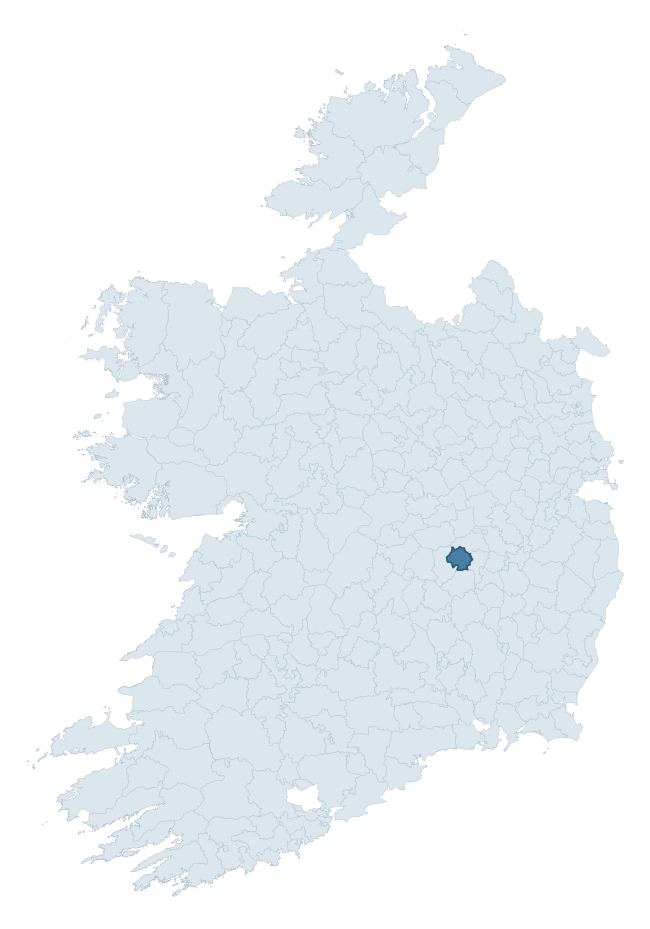
Where this barony sits in the Republic of Ireland
Geology and preservation
Bedrock geology shapes the landscape long before any settlement begins — controlling soil drainage, agricultural potential, the survival of upstanding monuments, and the preservation of buried archaeology. The figures below come from the Geological Survey Ireland 1:100,000 bedrock map.
The bedrock underlying Maryborough East is predominantly limestone (92% of the barony by area), laid down during the Carboniferous period (100% by area, around 359 to 299 million years ago). Limestone is the most heritage-rich bedrock in Ireland. It supports fertile, well-drained soils that favoured dense Early Medieval settlement and Norman manorial agriculture, and it weathers into karst features — sinkholes, caves, swallow holes, and souterrains — that frequently carry archaeology. Where peat overlies limestone, organic preservation can be exceptional. The single largest mapped unit is the Ballysteen Formation (42% of the barony's bedrock).
Rock type composition
Largest mapped unit: Ballysteen Formation (42% of the barony)
Placename evidence
Logainm records 13 heritage-diagnostic placenames for Maryborough East, a modest sample drawn predominantly from the townland record. The dominant stratum is pre-christian defensive. The most frequent diagnostic roots are ráth- (4) and cill- (4). With a sample of this size the count should be treated as indicative rather than definitive.
Pre-Christian / Early Medieval Defensive
| Root | Count | Meaning |
|---|---|---|
| ráth- | 4 | earthen ringfort |
| dún- | 2 | hilltop or promontory fort |
Early Christian Ecclesiastical
| Root | Count | Meaning |
|---|---|---|
| cill- | 4 | church (early) |
| díseart- | 1 | hermitage |
Burial, Ritual, and Norse-Contact
| Root | Count | Meaning |
|---|---|---|
| carn- | 1 | cairn |
| sián- | 1 | fairy mound |
Other baronies in Laois
About this profile
Click any section below to expand.
What is a barony?
A barony is a historic administrative unit in Ireland, broadly equivalent to an English hundred. The 280 baronies used here are from the OSi 2019 National Statutory Boundaries (generalised 20m), covering the 26 counties of the Republic of Ireland. Baronies derive from the Norman period, were formalised in the 17th century, and have not been redrawn for statistical purposes. They vary enormously in area, from compact urban baronies in Dublin to vast upland baronies in Connacht, and should not be compared by raw site count without accounting for area differences.
What counts as a site?
This profile combines three distinct heritage registers, each with its own definition of what constitutes a recordable site:
- Archaeological sites (NMS). The National Monuments Service Sites and Monuments Record (SMR) catalogues every known archaeological monument or site of archaeological interest in the Republic, from prehistoric burial mounds and ringforts to medieval churches and post-medieval defensive works. Inclusion does not require legal protection — only that the site has been identified, surveyed, and assessed as having archaeological value. A separate subset of these sites lies within a recorded protection zone, which gives them statutory protection under the National Monuments Acts.
- Listed buildings (NIAH). The National Inventory of Architectural Heritage records buildings of architectural, historical, archaeological, artistic, cultural, scientific, social, or technical interest. Each surveyed structure is appraised on a five-tier scale: International, National, Regional, Local, and Record-Only. The NIAH appraisal is informational rather than strictly statutory, but it underpins local-authority Record of Protected Structures (RPS) listings.
- Heritage placenames (Logainm). Logainm is the authoritative database of Irish placenames maintained by the Placenames Branch. This profile applies a heritage-diagnostic classifier to the Irish-language form of each townland name, flagging roots that signal defensive sites (ráth-, lios-, dún-, caiseal-, cathair-), ecclesiastical foundations (cill-, teampall-, domhnach-, mainistir-), prehistoric burial-ritual features (tuaim-, carn-, leaba-), or Norse-contact settlement (gall-). Townlands without one of these diagnostic roots are not flagged here — they may still carry historical significance, but that significance is not encoded in the name itself.
Editorial principles
The narrative sections of this profile follow several explicit principles:
- Evidential. Every claim about this barony’s heritage character is anchored in the underlying register data. Where a site count, a placename count, or a percentile rank is cited, it is computed from the source datasets at export time, not estimated.
- Comparative. Counts and metrics are reported alongside their percentile rank against the other 279 ROI baronies. A barony with 50 ringforts in absolute terms could be unusually high or unusually low depending on its size and regional context; percentile ranking removes that ambiguity.
- Transparent on limits. Where a register has known coverage gaps, survey biases, or data-quality issues that affect this barony’s figures, the profile flags them rather than presenting the numbers as definitive.
- No interpretation beyond what the data supports. The narrative does not speculate about historical events, social dynamics, or cultural meaning beyond what the recorded heritage and placename evidence directly attests.
Data caveats and limits
- NMS Sites and Monuments Record is the product of survey campaigns conducted at different intensities across different counties and decades. Some baronies have been surveyed more thoroughly than others, and absolute counts should be read in that light. Sites destroyed by development before survey are typically not represented; sites in heavily forested or upland terrain are sometimes under-recorded.
- NIAH coverage is broadly complete for the Republic of Ireland but the survey was conducted on a rolling county-by-county basis, and the most recent appraisal date varies. Buildings demolished or substantially altered after their original survey may still appear in the register; conversely, recent buildings of merit may not yet have been appraised.
- Logainm classification applies a deliberately conservative pattern-matching approach to the Irish-language townland forms. The classifier prioritises true positives over recall: a townland may carry a heritage signal that the classifier doesn’t recognise, particularly where the diagnostic root has been heavily anglicised or where the townland name draws on a less common term. The 60,000+ townland records and ~9,800 classified placenames give a substantial signal at barony scale, but individual townland names should be checked against Logainm directly for definitive interpretation.
- Period attribution. The chronological distribution reflects only those NMS sites that carry a recognised period attribution in the source data. Sites listed as “Unknown” period are excluded from the dated subset.
- Boundary changes. Some baronies have undergone minor boundary adjustments since their 19th-century definition; the OSi 2019 generalised boundaries used here are the current statutory definition and may differ slightly from historical maps in border areas.
- Bedrock geology is mapped at 1:100,000 scale, which means local variation within a barony — small pockets of different rock type, mineral veins, alluvium overlying bedrock — is generalised. The dominant-system and rocktype figures are area-weighted, so a barony reading “70% Carboniferous limestone” may still contain small but archaeologically important pockets of older or younger rock. Around 3% of GSI polygons do not match the lexicon and contribute no rocktype or system attribution.
Data sources
- National Monuments Service — Sites and Monuments Record (SMR) https://data.gov.ie/dataset/national-monuments-service-archaeological-survey-of-ireland
- National Inventory of Architectural Heritage (NIAH) https://data.gov.ie/dataset/national-inventory-of-architectural-heritage-niah-national-dataset
- Logainm — Placenames Database of Ireland https://www.logainm.ie/
- Ordnance Survey Ireland — National Statutory Barony Boundaries 2019 https://data-osi.opendata.arcgis.com/
- EURODEM — European Digital Elevation Model https://www.mapsforeurope.org/datasets/euro-dem
- ESA WorldCover https://esa-worldcover.org/en
- Geological Survey Ireland — 1:100,000 Bedrock Geology https://www.gsi.ie/en-ie/data-and-maps/Pages/Bedrock.aspx
Explore more: Search any of the 280 ROI baronies, browse by historical province, or read the methodology and data sources for the full Republic of Ireland Heritage Tool.