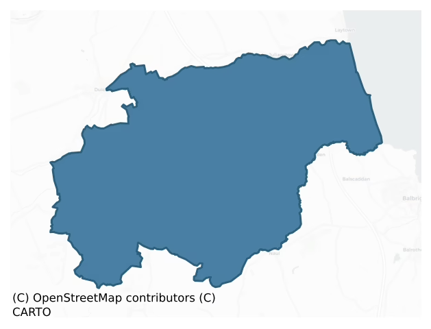
Duleek Upper is a barony of County Meath, in the historical province of Leinster (Irish: Damhliag Uachtarach), covering 116 km² of land. The barony records 334 NMS archaeological sites and 37 NIAH listed buildings, placing it at around the 79th percentile among 280 ROI baronies for sites per km². This means it is in the top third of all baronies for sites per km². Dated archaeological evidence runs from the Neolithic through to the Post Medieval, spanning 7 of 9 archaeological periods, placing the barony in the 40th percentile among 280 ROI baronies for chronological depth. This means it is in the lower half of all baronies for chronological depth. The largest dated subset of recorded sites dates to the Iron Age.
Heritage at a glance
Percentile rankings throughout this profile compare each barony only against the other 279 Republic of Ireland baronies.
The recorded heritage of Duleek Upper
The National Monuments Service Sites and Monuments Record (SMR) is the statutory inventory of archaeological sites for the Republic of Ireland, maintained by the Department of Tourism, Culture, Arts, Gaeltacht, Sport and Media. Sites recorded here include earthworks, ringforts, megalithic tombs, ecclesiastical remains, and post-medieval features; not every record is legally protected, but each is registered as a monument of archaeological interest.
The National Monuments Service records 334 archaeological sites in Duleek Upper, putting it at the 79th percentile among 280 ROI baronies for sites per km². This means it is in the top third of all baronies for sites per km². Of these, 299 (90%) fall within a recorded monument protection zone. The record is dominated by defensive sites — ringforts, enclosures, hillforts, and stone forts (101 sites, 30% of the total), with burial and ritual monuments forming a substantial secondary presence (80 sites, 24%). Ring-ditch is the most prevalent type, making up 18% of the barony's recorded sites (60 records) — well above the ROI average of 6% across all baronies where this type occurs. Ring-ditch is a circular ditch under 20m across, often the ploughed-out remains of a barrow, ring-barrow or roundhouse. Other significant types include Enclosure (52) and Ringfort – rath (27). Enclosure is a banked or ditched feature of uncertain type, used as a catch-all where the original function cannot be determined from surface evidence; Ringfort – rath is an earthen ringfort enclosed by a bank and external ditch — the most common Early Medieval farmstead, broadly dated 500–1000 AD. Across the barony's 116 km², this gives a recorded density of 2.89 sites per km².
Most common monument types
Hover or tap a monument type to see its definition.
| Type | Count |
|---|---|
| Ring-ditch a circular ditch under 20m across, often the ploughed-out remains of a barrow, ring-barrow or roundhouse | 60 |
| Enclosure a banked or ditched feature of uncertain type, used as a catch-all where the original function cannot be determined from surface evidence | 52 |
| Ringfort – rath an earthen ringfort enclosed by a bank and external ditch — the most common Early Medieval farmstead, broadly dated 500–1000 AD | 27 |
| Field system a group of related fields forming a coherent agricultural landscape, of any date from the Neolithic onwards | 17 |
| Church a building used for public Christian worship, of any date from c. 500 AD onwards | 13 |
| Fulacht fia a horseshoe-shaped Bronze Age burnt mound built around a sunken trough beside a water source, traditionally interpreted as a cooking site | 11 |
Chronological distribution
The dated archaeological record for Duleek Upper spans from the Neolithic through to the Post Medieval, with activity attested across 7 of 9 archaeological periods. Every period from earliest to latest is represented in the record — an unbroken sequence of dated activity across the full chronological span. Activity concentrates most heavily in the Iron Age (91 sites, 44% of dated material), with the Middle Late Bronze Age forming a secondary peak (38 sites, 18%). A further 126 recorded sites (38% of the overall NMS register for the barony) carry no period attribution — appearing as 'Unknown' in the bar chart below. This typically reflects either records that pre-date the standardised period vocabulary or sites awaiting specialist dating review, rather than a genuine absence of chronological evidence.
Sample of recorded monuments
Show 25 sample monuments (of 334 total)
A representative sample of 25 recorded monuments drawn from the barony’s 334 total NMS entries. Sites within a recorded monument protection zone and rarer site types are prioritised so the list shows a meaningful cross-section rather than only the most common type. Each entry shows the official Sites and Monuments Record reference number and the description published by the National Monuments Service.
Cross – Wayside cross (present location)
from King (1984, 106-7) This cross was originally a wayside monument on the Downstown road after which it served as a gable cross on the church in Duleek. In 1969 it was set up on the left-had side of the road as one…
from King (1984, 106-7) This cross was originally a wayside monument on the Downstown road after which it served as a gable cross on the church in Duleek. In 1969 it was set up on the left-had side of the road as one enters the village of Duleek from Drogheda. It was damaged in 1981 and re-erected in 1982 by the Duleek Historical Society about 0.5kmn nearer Drogheda on the same side of the road. The material is fossiliferous limestone. Dims of base 0.21m x 0.13m; H 1.45m; Wth 0.74m.
This is a Latin cross, rectangular in section, with splayed ends on the arms and upper shaft. It is decorated on the north and south faces and the edges of the shaft are chamfered. The base is modern. The W and E sides have no decoration. The N has the following inscription in false relief using Gothic lettering with Roman Capitals: HIS / PRAY FOR THE SOULES OF THO / MASSINA BERFORD FIRST EIFE / TO BERT / HELMEME / MOUR OF / DOWAN / STOWENE / WHO DIE / D THE 17 / OF DEC / EMBER 1635. The S side has an all-over pattern of shallow grooved lines. This cross is dated by its inscription to 1635.
Cogan (1862-70, 2, 232)
See the attached image.
Date of upload: 7 August, 2014
Armorial plaque (present location)
A stone with an armorial crest supported by two angels that came from the church at Irishtown (ME028-017—-) is built into a wall of Mosney House (Ward 1965, 255). It bears the arms of Barnwall with a family…
A stone with an armorial crest supported by two angels that came from the church at Irishtown (ME028-017—-) is built into a wall of Mosney House (Ward 1965, 255). It bears the arms of Barnwall with a family represented by a toothed cross, and is probably 16th century in date. A decorated spandrel (ME028-012003-) is also in the wall.
The above description is derived from the published 'Archaeological Inventory of County Meath' (Dublin: Stationery Office, 1987). In certain instances the entries have been revised and updated in the light of recent research.
Compiled by: Michael Moore
Date of upload/revision: 23 December, 2014
Castle – motte
Circular, flat-topped and grass-covered mound (diam. of top 10m; diam. of base 27m; H 3.5-5m) with some trees defined by the remains of a fosse (at WNW: Wth c. 6m; ext. D 0.5m). It may be the mound described by Hartnett…
Circular, flat-topped and grass-covered mound (diam. of top 10m; diam. of base 27m; H 3.5-5m) with some trees defined by the remains of a fosse (at WNW: Wth c. 6m; ext. D 0.5m). It may be the mound described by Hartnett (PRIA 1957, 263) as being in Raholland, which is the next townland to the W.
The above description is derived from the published 'Archaeological Inventory of County Meath' (Dublin: Stationery Office, 1987). In certain instances the entries have been revised and updated in the light of recent research.
Date of revision: 2 June 2016
Sheela-na-gig
A female exhibitionist figure was discovered hidden in a masonry pier at the entrance to a farmhouse ‘several years ago’ and is kept at the farm. The figure is carved in relief on a limestone block (max. dims 0.54m x…
A female exhibitionist figure was discovered hidden in a masonry pier at the entrance to a farmhouse ‘several years ago’ and is kept at the farm. The figure is carved in relief on a limestone block (max. dims 0.54m x 0.28m; max. T 0.24m). The legs are bent in the same direction and the hands are on the thighs indicating the pudenda. The breasts are only lightly indicated but the facial features are prominent. (Keeling 1984)
The above description is derived from the published 'Archaeological Inventory of County Meath' (Dublin: Stationery Office, 1987). In certain instances the entries have been revised and updated in the light of recent research.
Date of revision: 27 January 2017
Hillfort
This monument is described by Stout (1991, 259-63) as:
This monument was first detected through aerial survey undertaken by Swan. It is situated on the exposed southern slope of a narrow ridge 1km west-north-west of…
This monument is described by Stout (1991, 259-63) as:
This monument was first detected through aerial survey undertaken by Swan. It is situated on the exposed southern slope of a narrow ridge 1km west-north-west of the Fourknocks / Micknanstown enclosure (ME033-025—-) and 700m to the west-south-west of Micknanstown (ME033-013—-). Geology and soil type are similar to Fourknocks. The enclosure has been referred to as two separate sites: a ringfort, which has been incorporated into a field fence, and a mound (Hartnett 1957, 264). On the ground are two apparently unrelated segments of bank, but aerial photographs have shown these to be connected by a very low earthwork partly enclosing a large, oval, intensively cultivated area. Overall, the enclosure probably had a maximum north-west to south-east diameter of 200m. The enclosing bank, where preserved, tends to be flat-topped with a maximum height of 1.7m and an average width of 12m. The interior of the enclosure is again slightly dome-shaped. There is no evidence for a ditch associated with the enclosure. The field fence, which runs E-W across the centre of the monument, takes a pronounced bend around a circular depression in the interior of the enclosure. Hartnett (1957, 264) noted two circular areas, each 6m in diameter, which he believed to be house sites (within a ringfort) enclosed by the northern circuit of bank.
(Hartnett 1957, 264. Thornton 1980, 92-3; Moore 1987, 40, No. 306)
Date of revision: 10 January…
Henge
This monument is described by Stout (1991, 265-7) as:
This monument, shown as a segment of curved field fence on the OS 6-inch map and noted by Hartnett (1957, 265-7) as having ‘henge’ characteristics, lies at the…
This monument is described by Stout (1991, 265-7) as:
This monument, shown as a segment of curved field fence on the OS 6-inch map and noted by Hartnett (1957, 265-7) as having ‘henge’ characteristics, lies at the base of a ridge running E-W, N of the River Delvin. This is a well-drained tillage area with geology and soil type similar to the Fourknocks /Micknanstown enclosure (ME033-025—-). A mound (ME033-013—-), 26m SE of the enclosure, is probably a satellite passage tomb within the Fourknocks cemetery. The site at Fourknocks /Micknanstwotn lies 625m to the south-east, while the enclosure at Heathtown (ME033-011—-) is 700m away to the west-south-west. This embanked enclosure is roughly circular in plan, with a maximum overall diameter of 140m. The bank varies in height from 0.6m in the E, where it has been denuded by constant ploughing, to 1.5m in the SW, where it had been preserved as part of a field boundary. The well-preserved portion of the enclosing bank is flat-topped with an average width of 12m, while the ploughed segment reaches a maximum width of 19m. A depression, 12m wide, can be traced along the inside perimeter of the bank, except for the segment N of the road. This scarped area, which provided the bank material, gives the interior of the enclosure a domed shape. The resistivity survey did not detect this scarped area, which indicates a shallow depth for this feature. There are indications of a break in the bank in the E, but a section taken through…
Megalithic structure
The following description is derived from the published 'Archaeological Inventory of County Meath' (Dublin: Stationery Office, 1987). In certain instances the entries have been revised and updated in the light of recent…
The following description is derived from the published 'Archaeological Inventory of County Meath' (Dublin: Stationery Office, 1987). In certain instances the entries have been revised and updated in the light of recent research.
Date of upload/revision: 10 July 2007
Megalithic Structure Situated some 50m to E of passage-tomb (ME033-028001-) this site, on excavation in 1950-2, was shown to be a composite monument. It comprised an ovoid mound (ME033-029003-) with cists and pit burials (ME033-029004- and ME033-029005-) which covered, at SW, a small cairn (ME033-029002-) and, at NE, a megalithic passage with a transverse fosse at its SE end; both passage and transverse fosse contained burials. The primary finds indicate that the monument was constructed by passage-tomb peoples. (PRIA 1971, 35-83)
This monument is subject to a preservation order made under the National Monuments Acts 1930 to 2014 (PO no. 18/1976).
Stone circle
The Archaeological Survey of Ireland (ASI) is in the process of providing information on all monuments on The Historic Environment Viewer (HEV). Currently the information for this record has not been uploaded. To…
The Archaeological Survey of Ireland (ASI) is in the process of providing information on all monuments on The Historic Environment Viewer (HEV). Currently the information for this record has not been uploaded. To access available information for research purposes please make an appointment in advance with the Archive Unit (open Fridays 10.00 am – 5.00 pm), Department of Culture, Heritage and the Gaeltacht, The Custom House, Dublin 1 D01W6XO or email nmarchive@chg.gov.ie.
Burnt mound
The Archaeological Survey of Ireland (ASI) is in the process of providing information on all monuments on The Historic Environment Viewer (HEV). Currently the information for this record has not been uploaded. To…
The Archaeological Survey of Ireland (ASI) is in the process of providing information on all monuments on The Historic Environment Viewer (HEV). Currently the information for this record has not been uploaded. To access available information for research purposes please make an appointment in advance with the Archive Unit (open Fridays 10.00 am – 5.00 pm), Department of Culture, Heritage and the Gaeltacht, The Custom House, Dublin 1 D01W6XO or email nmarchive@chg.gov.ie.
House – medieval
Situated on a knoll on a gentle SE-facing slope, with a S-N section of the Delvin River c. 50m to the E and c. 10m S of the S boundary of the graveyard at Stamullin church (ME034-001—-). Archaeological testing…
Situated on a knoll on a gentle SE-facing slope, with a S-N section of the Delvin River c. 50m to the E and c. 10m S of the S boundary of the graveyard at Stamullin church (ME034-001—-). Archaeological testing (95E0143) produced evidence of a house floor cut into the subsoil with an occupation layer (L c. 4m; Wth c. 1.5m), which was cut by a pit, and a hearth. Medieval pottery post-dated this house. (Swan 1996a; 1996b)
Compiled by: Michael Moore
Date of upload: 11 February, 2015
Passage tomb art
The Archaeological Survey of Ireland (ASI) is in the process of providing information on all monuments on The Historic Environment Viewer (HEV). Currently the information for this record has not been uploaded. To…
The Archaeological Survey of Ireland (ASI) is in the process of providing information on all monuments on The Historic Environment Viewer (HEV). Currently the information for this record has not been uploaded. To access available information for research purposes please make an appointment in advance with the Archive Unit (open Fridays 10.00 am – 5.00 pm), Department of Culture, Heritage and the Gaeltacht, The Custom House, Dublin 1 D01W6XO or email nmarchive@chg.gov.ie.
Mass-rock
A rough irregular shaped boulder (L 1.5m, Wth 0.75m, H 0.6m) on the summit of a ridge running E-W, in a field of pasture. Views are restricted to the S and it overlooks the sea in the E. A wayside cross formerly stood…
A rough irregular shaped boulder (L 1.5m, Wth 0.75m, H 0.6m) on the summit of a ridge running E-W, in a field of pasture. Views are restricted to the S and it overlooks the sea in the E. A wayside cross formerly stood in this field and the field is known locally as the mass-rock field (pers. comm. Colin Byrne)
Compiled by: Claire Breen
Date of upload: 10 December 2013
Mill – corn
According to the Civil Survey (1654-6) of Stamullin parish 390 acres at Tullocke were owned by Lord Gormonstowne and on the land was a farm house and a corn mill (Simington 1940, 11). The millpond of the ‘old mill of…
According to the Civil Survey (1654-6) of Stamullin parish 390 acres at Tullocke were owned by Lord Gormonstowne and on the land was a farm house and a corn mill (Simington 1940, 11). The millpond of the ‘old mill of Tullock’ is described as part of the bounds of land at Reynoldstown, Co. Dublin in the same survey of Co. Dublin (Simington 1945, 34). A description of the manor of Naul from the Gormanston papers (MS 44,346/5-8) in 1633 included two mills, a watermill to grind corn and a tuck mill (Tiernan 2008, 17). The mill is depicted on Dunca’s mp of 1821, and a functioning building is annotated as a Flour Mill on the 1838 edition of the OS 6-inch map. The mill appears to have been still functioning on the 1906 edition and it is now a private residence. The mills have been researched by Brendan Matthews and Ian Lennon.
Compiled by: Michael Moore
Date of upload: 13 February 2023
Simington, R. C. 1940 The Civil Survey. Vol. V, County of Meath. Dublin, Stationary Office
Simington, R. C. 1945 The Civil Survey. Vol. VII, County of Dublin. Dublin, Stationary Office
Tiernan, S. 2008 Collection List No. 132 Gormanston Papers. Typescript, National Library of Ireland
Ringfort – unclassified
Identified on OS (1995) aerial photography as a double-ditched, sub-circular enclosure. Local tradition of fort on the site (pers. comm. Mr Colin Byrne, Briarleas, County Meath).
Compiled by Geraldine Stout
Date…
Identified on OS (1995) aerial photography as a double-ditched, sub-circular enclosure. Local tradition of fort on the site (pers. comm. Mr Colin Byrne, Briarleas, County Meath).
Compiled by Geraldine Stout
Date of upload: 13/03/2012
Castle – ringwork
Located in a field known as the 'Castle field' in the townland of Hollymount. Comprises a large flat-topped mound (diam. c 25m). Referred to locally as the 'old fort' and that a 'tunnel leads from the mound all the way…
Located in a field known as the 'Castle field' in the townland of Hollymount. Comprises a large flat-topped mound (diam. c 25m). Referred to locally as the 'old fort' and that a 'tunnel leads from the mound all the way to Herbertstown' (pers. comm. Mr Colin Byrne, Briarleas, County Meath). It is visible as a circular, grass-covered area defined by a broad bank feature (Wth c. 10m) and an outer fosse feature (max. ext. diam. c. 55m) on Bing aerial images (c. 2013). It may be a ringwork castle.
Compiled by Geraldine Stout
Date of revised upload: 02/06/2016
Wall monument
The pointed chancel arch of Moorechurch parish church (ME028-010—-) survives complete and has a plaque (dims 0.69m x 0. 31m) commemorating Dame Janet Sarsfield, dowager of Dunsany, who died in 1597 and is buried in…
The pointed chancel arch of Moorechurch parish church (ME028-010—-) survives complete and has a plaque (dims 0.69m x 0. 31m) commemorating Dame Janet Sarsfield, dowager of Dunsany, who died in 1597 and is buried in the church inserted on the N pier (Du Noyer 1896, 325; FitzGerald 1904, 124). The plaque, which had been lying loose in the church (Cogan 1862-70, 2, 254) has Roman lettering in relief and reads: HERE INTER LIETHE / THE BODY OF DAME IE / NET SARSFELD LADY / DOWAGER OF DONSANY / WHO DYED THE XXII OF / FEBRUARY AN. DN. 1597.
Compiled by: Michael Moore
Date of upload: 23 December, 2014
Graveslab
A graveslab of Thomas Buckley dated 1617 that was in the chancel of Moorchurch parish church (ME028-010—-) cannot be identified. It is described (Dix 1898-1900, 461) as being in two pieces and having a figure of a man…
A graveslab of Thomas Buckley dated 1617 that was in the chancel of Moorchurch parish church (ME028-010—-) cannot be identified. It is described (Dix 1898-1900, 461) as being in two pieces and having a figure of a man in 'Elizabethan costume' at the centre and a fragmentary inscription around three sides that reads: HERE LIETH THE BODIE OF / THOMAS BUCKELY, GENT, WHO DI– / –OCTOBER, 1617.
Compiled by: Michael Moore
Date of upload: 23 December, 2014
Memorial stone
The tower house (ME033-004—-) was erected for William Bathe and his wife, Jane Dowdall, in 1590. There is a commemorative stone placed high at the SW end of the external SE wall of the revamped extension with two…
The tower house (ME033-004—-) was erected for William Bathe and his wife, Jane Dowdall, in 1590. There is a commemorative stone placed high at the SW end of the external SE wall of the revamped extension with two crests within wreaths and an inscription. It reads: WB ID 1590 (Grose 1791, 2, 33).
Compiled by: Michael Moore
Date or upload; 13 July, 2016
Water mill – unclassified
Situated on a S-facing slope down to the W-E River Delvin which is c. 75m distant. It is also on the E bank of a mill-race that originated far upstream and an overflow mill-race is on its E side. According to the Civil…
Situated on a S-facing slope down to the W-E River Delvin which is c. 75m distant. It is also on the E bank of a mill-race that originated far upstream and an overflow mill-race is on its E side. According to the Civil Survey (1654) in 1641 Lord Gormanston, an Irish Papist, owned 390 acres at Gormanston, and on the premises were a stone house with outhouses, by which is meant the castle, about ‘20 farm houses in the town’ and two water mills (Simington 1940, 10). A functioning corn mill is marked here W of the Balrothery to Drogheda road on the 1836 and 1908 editions of the OS 6-inch map. The mill was known as Arnold’s mill from a tenant named Arnold who was evicted from it in 1881 (B. Matthews, Drogheda Independent, 07/05/1999). A direct connection with the seventeenth century mill cannot be established but is very likely. The remains of a small structure still survives, overgrown with ivy (pers. com. I. Lennon 14/02/2013).
Compiled by: Michael Moore
Date of upload; 11 April, 2023
Simington, R. C. 1940 The Civil Survey AD 1654-1658 vol. 5, County of Meath. Stationary Office, Dublin
Inscribed stone
The remains of Bellewstown castle stand c. 30m E of the present Bellewstown House. On a building to the E of Bellewstown castle , known as the Lodge, there are two inscribed stones which when combined with a third stone…
The remains of Bellewstown castle stand c. 30m E of the present Bellewstown House. On a building to the E of Bellewstown castle , known as the Lodge, there are two inscribed stones which when combined with a third stone in Sarsefieldstown form a full inscription that commemorates John Bellew repairing the steps and door of Bellewstown castle in 1598 (pers comm. Mr Colin Byrne, Briarleas, County Meath). The W plaque reads: THE ARMES / KNIGHT AND HIS W / NUGENT AND IE / S STEPPES AND / OUR LORD GOD / 1598. (O'Boyle 1984)
The above description is derived from the published 'Archaeological Inventory of County Meath' (Dublin: Stationery Office, 1987). In this instance the entry have been revised and updated in the light of recent research.
Compiled by: Michael Moore
Date of revision: 10 October, 2014
Font
The following description is derived from the published 'Archaeological Inventory of County Meath' (Dublin: Stationery Office, 1987). In certain instances the entries have been revised and updated in the light of recent…
The following description is derived from the published 'Archaeological Inventory of County Meath' (Dublin: Stationery Office, 1987). In certain instances the entries have been revised and updated in the light of recent research.
Date of upload/revision: 10 July 2007
Octagonal font with champfered lower portion and resting on octagonal base. Used as holy water font in RC church.
Embanked enclosure
This monument is described by Stout (1991, 259) as:
This enclosure, first detected through aerial survey undertaken by Swan, is located on a north-facing slope above the River Delvin. The underlying geology is…
This monument is described by Stout (1991, 259) as:
This enclosure, first detected through aerial survey undertaken by Swan, is located on a north-facing slope above the River Delvin. The underlying geology is limestone and shale on which a grey-brown podzolic has developed. The ridge is crowned by the Fourknocks passage tomb (Hartnett 1957, 265). This monument is the smallest of a group of three enclosures 1.5km north-west of Fourknocks passage tomb. Heathtown (ME033-011—-) is 1km to the west-north-west and Micknanastown (ME033-013—-) is 625m to the north-west. A bank encloses a roughly circular area. It has a maximum overall diameter of 110m, an average height of only 0.5m and is 10-20m wide at its base. The interior is saucer-shaped, probably as a result of using materials scarped from the interior for the construction of the bank. There is no evidence for a ditch. Spot phosphate and magnetic susceptibility readings were high along the inside of the embankment, indicating the presence of burning or burial activity. In the north-north-west segment of the enclosure (283 degrees T) there is a 5m –wide break in the bank which is probably an original opening. (Thornton 1980, 90-1; Moore 1987, 40, No. 305)
Date of revision: 10 January 2017
Cairn – unclassified
The following description is derived from the published 'Archaeological Inventory of County Meath' (Dublin: Stationery Office, 1987). In certain instances the entries have been revised and updated in the light of recent…
The following description is derived from the published 'Archaeological Inventory of County Meath' (Dublin: Stationery Office, 1987). In certain instances the entries have been revised and updated in the light of recent research.
Date of upload/revision: 10 July 2007
Earth and clay cairn (diam. 8m H 1m) surrounded by berm and fosse. covering pit burial (PRIA 1971, 39, 40) Covered by cemetery mound (ME033-029003-).
This monument is subject to a preservation order made under the National Monuments Acts 1930 to 2014 (PO no. 18/1976).
House – 16th/17th century
Situated on a rise in a level landscape with the S-N Hurley River c. 70m to the E. A nineteenth century illustration of Athcarne castle (Anon. 1833) depicts it as a four storey tower house, which has a two storey house…
Situated on a rise in a level landscape with the S-N Hurley River c. 70m to the E. A nineteenth century illustration of Athcarne castle (Anon. 1833) depicts it as a four storey tower house, which has a two storey house attached at the SW side. The house has a return to the NW at the SW end and a large chimney stack rising from the first floor on the NW external wall. Another view (Grose 1791, 2, 33) shows two returns at the opposite (SE) side of the house. The tower house continued to be occupied into the nineteenth century and was considerably altered by the insertion of large windows on the upper floors, but the attached house was replaced by a new wing after 1833 that is still extant as a ruin. The heraldic stone with the date 1590 (ME033-004002-) is built high in the external face of the SE wall of this structure at its S end.
The above description is derived from the published 'Archaeological Inventory of County Meath' (Dublin: Stationery Office, 1987). In certain instances the entries have been revised and updated in the light of recent research.
This is a National Monument in state ownership, No. 539.
Compiled by: Michael Moore
Date of revision: 6 July 2016
Ring-ditch
An aerial photograph (OSAP, 1995) shows the cropmark of a ring-ditch (diam. c. 10m). (Pers com. Colin Byrne).
See the attached enhanced view from OSAP (1995)
Date of upload: 15 September, 2017
Listed buildings
The National Inventory of Architectural Heritage (NIAH) is a state survey appraising buildings of architectural, historical, archaeological, artistic, cultural, scientific, social, or technical interest. Each surveyed structure receives a rating from International (the highest, for buildings of European importance) through National, Regional, Local, and Record-Only.
The NIAH records only 37 listed buildings in Duleek Upper, the 17th percentile across ROI baronies — a relatively thin architectural record. The highest-graded structure include 1 of National significance. The Republic holds 937 National-graded buildings in total, so this barony accounts for around 0% of the national total. Construction dates concentrate most heavily in the Victorian (1830-1900) period.
Terrain and environment
Mean elevation across the barony is 67m — the 29th percentile among 280 ROI baronies for elevation. This means it is in the bottom third of all baronies for elevation. This is a relatively low-lying landscape by ROI standards. Elevation matters for heritage because higher-altitude baronies typically favour defensive monuments — ringforts and hilltop forts placed on prominent ground — while lowland baronies are more likely to carry the dense settlement and church networks of intensive agricultural landscapes. Mean slope is 3.2° — the 43rd percentile among 280 ROI baronies for slope. This means it is in the lower half of all baronies for slope. Slope is a key control on both land use and archaeological preservation: steep ground resists ploughing and tends to preserve earthworks intact, while gentle slopes favour intensive cultivation that damages or destroys surface archaeology over time. The Topographic Wetness Index averages 10.9, the 53rd percentile among 280 ROI baronies for wetness. This means it is in the upper half of all baronies for wetness. Drainage matters for heritage because poorly-drained ground preserves organic archaeology (wooden trackways, leather, textiles, and on rare occasions human remains) far better than free-draining soil; well-drained ground favours arable use but destroys organic material rapidly. The land-cover mosaic combines improved grassland (61%), arable farmland (29%), and woodland (8%), giving a mixed agricultural and semi-natural landscape.
Terrain measurements
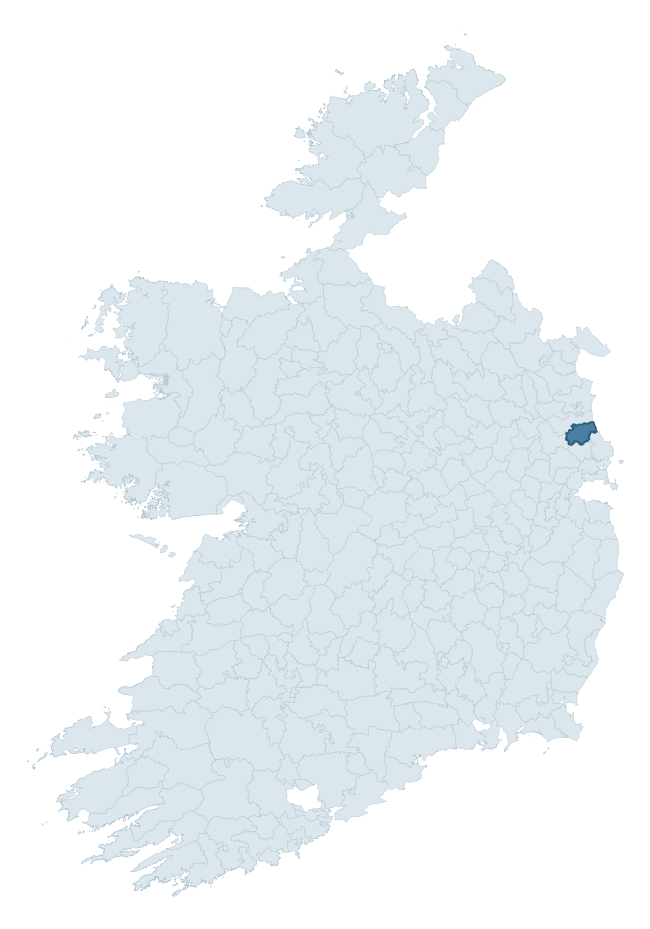
Where this barony sits in the Republic of Ireland
Geology and preservation
Bedrock geology shapes the landscape long before any settlement begins — controlling soil drainage, agricultural potential, the survival of upstanding monuments, and the preservation of buried archaeology. The figures below come from the Geological Survey Ireland 1:100,000 bedrock map.
The bedrock underlying Duleek Upper is predominantly sandstone and siltstone (37% of the barony by area), laid down during the Silurian period (65% by area, around 444 to 419 million years ago). A substantial secondary geology of siltstone (28%) and limestone (13%) adds further variety to the underlying landscape. The single largest mapped unit is the Denhamstown Formation (34% of the barony's bedrock). With 8 distinct rock types mapped, the barony sits in the top third of ROI baronies for geological diversity (81st percentile) — typically a sign of complex tectonic history or coastal mosaics of differing rock units.
Rock type composition
Largest mapped unit: Denhamstown Formation (34% of the barony)
Placename evidence
Logainm records 12 heritage-diagnostic placenames for Duleek Upper, a modest sample drawn predominantly from the townland record. The dominant stratum is early christian ecclesiastical. The most frequent diagnostic roots are carn- (3) and ráth- (2). With a sample of this size the count should be treated as indicative rather than definitive.
Pre-Christian / Early Medieval Defensive
| Root | Count | Meaning |
|---|---|---|
| ráth- | 2 | earthen ringfort |
| lios- | 1 | ringfort or enclosure |
Early Christian Ecclesiastical
| Root | Count | Meaning |
|---|---|---|
| cill- | 2 | church (early) |
| teampall- | 2 | church (later medieval) |
| mainistir- | 1 | monastery |
| gráinseach- | 1 | monastic farm / grange |
Burial, Ritual, and Norse-Contact
| Root | Count | Meaning |
|---|---|---|
| carn- | 3 | cairn |
Other baronies in Meath
About this profile
Click any section below to expand.
What is a barony?
A barony is a historic administrative unit in Ireland, broadly equivalent to an English hundred. The 280 baronies used here are from the OSi 2019 National Statutory Boundaries (generalised 20m), covering the 26 counties of the Republic of Ireland. Baronies derive from the Norman period, were formalised in the 17th century, and have not been redrawn for statistical purposes. They vary enormously in area, from compact urban baronies in Dublin to vast upland baronies in Connacht, and should not be compared by raw site count without accounting for area differences.
What counts as a site?
This profile combines three distinct heritage registers, each with its own definition of what constitutes a recordable site:
- Archaeological sites (NMS). The National Monuments Service Sites and Monuments Record (SMR) catalogues every known archaeological monument or site of archaeological interest in the Republic, from prehistoric burial mounds and ringforts to medieval churches and post-medieval defensive works. Inclusion does not require legal protection — only that the site has been identified, surveyed, and assessed as having archaeological value. A separate subset of these sites lies within a recorded protection zone, which gives them statutory protection under the National Monuments Acts.
- Listed buildings (NIAH). The National Inventory of Architectural Heritage records buildings of architectural, historical, archaeological, artistic, cultural, scientific, social, or technical interest. Each surveyed structure is appraised on a five-tier scale: International, National, Regional, Local, and Record-Only. The NIAH appraisal is informational rather than strictly statutory, but it underpins local-authority Record of Protected Structures (RPS) listings.
- Heritage placenames (Logainm). Logainm is the authoritative database of Irish placenames maintained by the Placenames Branch. This profile applies a heritage-diagnostic classifier to the Irish-language form of each townland name, flagging roots that signal defensive sites (ráth-, lios-, dún-, caiseal-, cathair-), ecclesiastical foundations (cill-, teampall-, domhnach-, mainistir-), prehistoric burial-ritual features (tuaim-, carn-, leaba-), or Norse-contact settlement (gall-). Townlands without one of these diagnostic roots are not flagged here — they may still carry historical significance, but that significance is not encoded in the name itself.
Editorial principles
The narrative sections of this profile follow several explicit principles:
- Evidential. Every claim about this barony’s heritage character is anchored in the underlying register data. Where a site count, a placename count, or a percentile rank is cited, it is computed from the source datasets at export time, not estimated.
- Comparative. Counts and metrics are reported alongside their percentile rank against the other 279 ROI baronies. A barony with 50 ringforts in absolute terms could be unusually high or unusually low depending on its size and regional context; percentile ranking removes that ambiguity.
- Transparent on limits. Where a register has known coverage gaps, survey biases, or data-quality issues that affect this barony’s figures, the profile flags them rather than presenting the numbers as definitive.
- No interpretation beyond what the data supports. The narrative does not speculate about historical events, social dynamics, or cultural meaning beyond what the recorded heritage and placename evidence directly attests.
Data caveats and limits
- NMS Sites and Monuments Record is the product of survey campaigns conducted at different intensities across different counties and decades. Some baronies have been surveyed more thoroughly than others, and absolute counts should be read in that light. Sites destroyed by development before survey are typically not represented; sites in heavily forested or upland terrain are sometimes under-recorded.
- NIAH coverage is broadly complete for the Republic of Ireland but the survey was conducted on a rolling county-by-county basis, and the most recent appraisal date varies. Buildings demolished or substantially altered after their original survey may still appear in the register; conversely, recent buildings of merit may not yet have been appraised.
- Logainm classification applies a deliberately conservative pattern-matching approach to the Irish-language townland forms. The classifier prioritises true positives over recall: a townland may carry a heritage signal that the classifier doesn’t recognise, particularly where the diagnostic root has been heavily anglicised or where the townland name draws on a less common term. The 60,000+ townland records and ~9,800 classified placenames give a substantial signal at barony scale, but individual townland names should be checked against Logainm directly for definitive interpretation.
- Period attribution. The chronological distribution reflects only those NMS sites that carry a recognised period attribution in the source data. Sites listed as “Unknown” period are excluded from the dated subset.
- Boundary changes. Some baronies have undergone minor boundary adjustments since their 19th-century definition; the OSi 2019 generalised boundaries used here are the current statutory definition and may differ slightly from historical maps in border areas.
- Bedrock geology is mapped at 1:100,000 scale, which means local variation within a barony — small pockets of different rock type, mineral veins, alluvium overlying bedrock — is generalised. The dominant-system and rocktype figures are area-weighted, so a barony reading “70% Carboniferous limestone” may still contain small but archaeologically important pockets of older or younger rock. Around 3% of GSI polygons do not match the lexicon and contribute no rocktype or system attribution.
Data sources
- National Monuments Service — Sites and Monuments Record (SMR) https://data.gov.ie/dataset/national-monuments-service-archaeological-survey-of-ireland
- National Inventory of Architectural Heritage (NIAH) https://data.gov.ie/dataset/national-inventory-of-architectural-heritage-niah-national-dataset
- Logainm — Placenames Database of Ireland https://www.logainm.ie/
- Ordnance Survey Ireland — National Statutory Barony Boundaries 2019 https://data-osi.opendata.arcgis.com/
- EURODEM — European Digital Elevation Model https://www.mapsforeurope.org/datasets/euro-dem
- ESA WorldCover https://esa-worldcover.org/en
- Geological Survey Ireland — 1:100,000 Bedrock Geology https://www.gsi.ie/en-ie/data-and-maps/Pages/Bedrock.aspx
Explore more: Search any of the 280 ROI baronies, browse by historical province, or read the methodology and data sources for the full Republic of Ireland Heritage Tool.