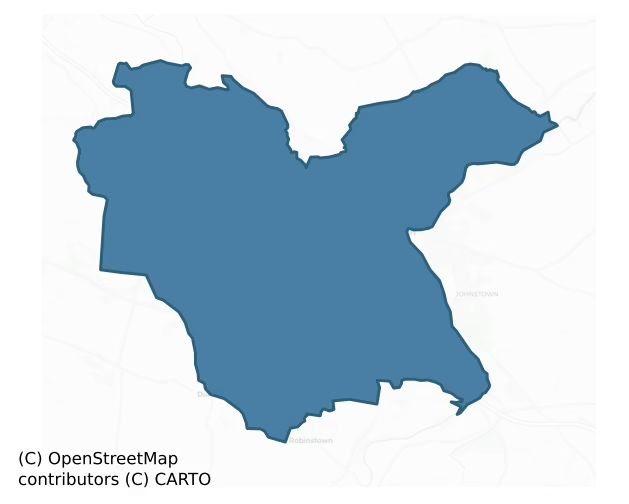
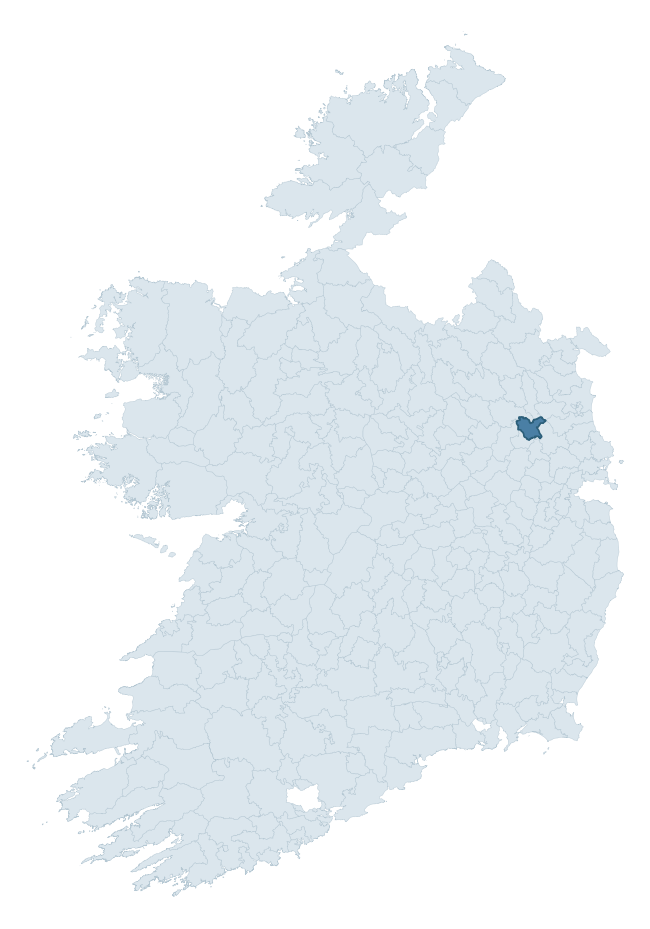
Navan Lower is a barony of County Meath, in the historical province of Leinster (Irish: An Uaimh Íochtarach), covering 102 km² of land. The barony records 229 NMS archaeological sites and 168 NIAH listed buildings, placing it at around the 63rd percentile among 280 ROI baronies for sites per km². This means it is in the upper half of all baronies for sites per km². Dated archaeological evidence runs from the Neolithic through to the Post Medieval, spanning 7 of 9 archaeological periods, placing the barony in the 28th percentile among 280 ROI baronies for chronological depth. This means it is in the bottom third of all baronies for chronological depth. The largest dated subset of recorded sites dates to the Iron Age.

Heritage at a glance
Percentile rankings throughout this profile compare each barony only against the other 279 Republic of Ireland baronies.
The recorded heritage of Navan Lower
The National Monuments Service Sites and Monuments Record (SMR) is the statutory inventory of archaeological sites for the Republic of Ireland, maintained by the Department of Tourism, Culture, Arts, Gaeltacht, Sport and Media. Sites recorded here include earthworks, ringforts, megalithic tombs, ecclesiastical remains, and post-medieval features; not every record is legally protected, but each is registered as a monument of archaeological interest.
The National Monuments Service records 229 archaeological sites in Navan Lower, putting it at the 63rd percentile among 280 ROI baronies for sites per km². This means it is in the upper half of all baronies for sites per km². Of these, 167 (73%) fall within a recorded monument protection zone. The record is dominated by defensive sites — ringforts, enclosures, hillforts, and stone forts (46 sites, 20% of the total), with ecclesiastical sites forming a substantial secondary presence (36 sites, 16%). The most diagnostically specific type is Ring-ditch (18 records, 8% of the barony's NMS total) — compared to an ROI average of 6% across all baronies where this type occurs. Ring-ditch is a circular ditch under 20m across, often the ploughed-out remains of a barrow, ring-barrow or roundhouse. The broader 'Enclosure' classification — which catches unclassified ringforts and field enclosures — accounts for a further 22 records (10%) and reflects the difficulty of sub-classifying degraded earthworks from surface evidence alone. Across the barony's 102 km², this gives a recorded density of 2.24 sites per km².
Most common monument types
Hover or tap a monument type to see its definition.
| Type | Count |
|---|---|
| Enclosure a banked or ditched feature of uncertain type, used as a catch-all where the original function cannot be determined from surface evidence | 22 |
| Ring-ditch a circular ditch under 20m across, often the ploughed-out remains of a barrow, ring-barrow or roundhouse | 18 |
| Ringfort – rath an earthen ringfort enclosed by a bank and external ditch — the most common Early Medieval farmstead, broadly dated 500–1000 AD | 14 |
| Graveyard a burial area associated with a church, in use from the medieval period onwards | 13 |
| Fulacht fia a horseshoe-shaped Bronze Age burnt mound built around a sunken trough beside a water source, traditionally interpreted as a cooking site | 13 |
| Church a building used for public Christian worship, of any date from c. 500 AD onwards | 12 |
| Excavation – miscellaneous | 11 |
Chronological distribution
The dated archaeological record for Navan Lower spans from the Neolithic through to the Post Medieval, with activity attested across 7 of 9 archaeological periods. Every period from earliest to latest is represented in the record — an unbroken sequence of dated activity across the full chronological span. Activity concentrates most heavily in the Iron Age (44 sites, 35% of dated material), with the Early Medieval forming a secondary peak (29 sites, 23%). A further 105 recorded sites (46% of the overall NMS register for the barony) carry no period attribution — appearing as 'Unknown' in the bar chart below. This typically reflects either records that pre-date the standardised period vocabulary or sites awaiting specialist dating review, rather than a genuine absence of chronological evidence.
Sample of recorded monuments
Show 25 sample monuments (of 229 total)
A representative sample of 25 recorded monuments drawn from the barony’s 229 total NMS entries. Sites within a recorded monument protection zone and rarer site types are prioritised so the list shows a meaningful cross-section rather than only the most common type. Each entry shows the official Sites and Monuments Record reference number and the description published by the National Monuments Service.
Moated site
Situated on a slight rise on a very gentle N-facing slope. This is a raised (H at N: 2.9m), rectangular and grass-covered area (dims 65m E-W; 21m N-S) defined by a severely eroded moat (at S: Wth of top 14m; int. D…
Situated on a slight rise on a very gentle N-facing slope. This is a raised (H at N: 2.9m), rectangular and grass-covered area (dims 65m E-W; 21m N-S) defined by a severely eroded moat (at S: Wth of top 14m; int. D 1.3m; ext. D 0.4m) on each side, that at N being reduced to a berm (Wth 4m). There may be a causeway towards the W end of the N side. It is overlaid by a NNE-SSW roadway towards the E edge of the platform, and the monument is best preserved at the SE angle which is E of the roadway where the E end of the S side is well preserved and there is an internal bank (Wth of base 6m; int. H 0.3m; ext. H 1.3m), a moat (Wth of top 10.3m; Wth of base 4m; ext. H 1.1m) and an outer bank (Wth of top 3m; ext. H 0.5m).
Compiled by: Michael Moore
Date of upload: 16 April 2019
Amended: 3 March 2023
Gatehouse
Situated on a level landscape, at the crest of a slight slope down to the NW-SE River Blackwater, which is c. 100m to the N. The house (ME025-009002-) is c. 70m to the NW. This is a rectangular structure (ext. dims 6.7m…
Situated on a level landscape, at the crest of a slight slope down to the NW-SE River Blackwater, which is c. 100m to the N. The house (ME025-009002-) is c. 70m to the NW. This is a rectangular structure (ext. dims 6.7m NW-SE; 4.7m NE-SW) with a round-arched entrance (Wth 2.8m) on the SW side. The entrance passage has a barrel-vault and a doorway in the SE pier leads to a newel stairs. The chamber above has single lights on the NW and SW sides.
The above description is derived from the published 'Archaeological Inventory of County Meath' (Dublin: Stationery Office, 1987). In certain instances the entries have been revised and updated in the light of recent research.
Compiled by: Michael Moore
Date of revision: 28 June 2016
Mound
Situated on a slight rise in a gently undulating landscape, and at the crest of a gentle slope down to a N-S section of the River Blackwater which is c. 150m distant and c. 5m lower. This was once on the demesne of…
Situated on a slight rise in a gently undulating landscape, and at the crest of a gentle slope down to a N-S section of the River Blackwater which is c. 150m distant and c. 5m lower. This was once on the demesne of Liscartan House (ME025-009002-) c. 550m to the NNW and is in full view of Rathaldron House (ME025-11—-) c. 270m to the NNE, on the other side of the river. It is depicted as a small copse on the 1836 edition of the OS 6-inch map and as a clump of trees on the 1908 edition. This is a grass-covered circular mound of earth and stones (diam. 23m; H 2.5m) that supports two trees. There are quarry holes on the NW side.
The above description is derived from the published 'Archaeological Inventory of County Meath' (Dublin: Stationery Office, 1987). In certain instances the entries have been revised and updated in the light of recent research.
Compiled by: Michael Moore
Date of upload: 10 July 2007
Revised: 29 March 2023
Castle – unclassified
Situated on a bluff (H c. 20m at S) overlooking a weir on a W-E section of the River Boyne which is c. 100m to the S and c. 20m lower. This could be an early castle but its history is obscure. It withstood a siege by…
Situated on a bluff (H c. 20m at S) overlooking a weir on a W-E section of the River Boyne which is c. 100m to the S and c. 20m lower. This could be an early castle but its history is obscure. It withstood a siege by rebels in 1641 until Captain Power, its commander, was persuaded to surrender. According to the Civil Survey (1654-6) Thomas Darcy owned the entire parish consisting of 395 acres in 1640, and on the premises there was ‘a Castle, a Church, a Mill, an Orchard and a fishing weare’ (Simington 1940, 322). The D’Arcy family appears to have retained the castle in the Cromwellian settlement and rebuilt it in the reign of James II (1685-89). A drawing from 1795 by Francis Grose (1795, 82-3) shows it an occupied rectangular structure but it is said to have been burned in the rising of 1798 when the north half of it collapsed (Wilde 1849, 166-9).
This is a large rectangular structure (dims c. 15m E-W; c. 10m N-S) with circular towers at the angles, but only those at SE and SW survive. The ground floor is buried but was vaulted and had a loft as well as well as two rows of long arrow-loops on the S wall which could indicated a thirteenth century date. There is a newel stairs in the SW tower which has a key-hole gun-loop. The first floor has large windows that are robbed. There is a two-storey gabled building with an oven at the ground floor attached to the E. The church (ME025-018001-) is immediately adjacent to the W. (Sweetman 1999, 99-100)
See the attached view…
Castle – motte and bailey
Situated on top of a fairly high ridge. According to the ‘Song of Dermot and the Earl’ Hugh de Lacy had granted the barony of Navan along with Ardbraccan to Jocelin de Angelo by 1175 (Orpen 1892, 229), and this motte…
Situated on top of a fairly high ridge. According to the ‘Song of Dermot and the Earl’ Hugh de Lacy had granted the barony of Navan along with Ardbraccan to Jocelin de Angelo by 1175 (Orpen 1892, 229), and this motte and bailey was undoubtedly the caput or centre of the fief. De Angelo, which name morphed into Nangle, probably adapted the burial mound of Odhbha, a mythological queen whose name was attached to a grave on a ridge as well as the surrounding territory (Moore 1893, 56-7). She was the estranged wife of Éremón, a leader of the last mythical Milesian invasion of Ireland, who followed him to Ireland from Spain with her own sons (Macalister 1931, 94-5). As a significant landmark the mound of Odhbha was the scene of important battles in 607, 890, 1016 and 1072 (Cogan 1862, vol. 1, 150).
The motte was described in 1969 (SMR file) as an overgrown, flat-topped and scrub-covered earthen mound (diam. of top 15m N-S; diam. of base 37m N-S; H 4.5m at N to 6.8m at S) defined by the remains of a fosse (at N: Wth of top c. 10m; ext. D 1.5m). There is a small lunate bailey (dims 7m N-S; c. 20m E-W) defined by a steep scarp (at N: ext. H 4m) at NW. The area to the S has been quarried since the 19th century and the quarry has extended around to the E, but the old quarry is now developed for housing. Archaeological testing (97E0101) by T. C. Breen c. 70m to the NW (excavations.ie 1997:427) recovered the remains of two inhumations, a male (aged 18-23) and a female (aged 31-45) in…
Religious house – Augustinian canons
The abbey of St. Mary at Navan may have been founded before the Anglo-Norman settlement of Meath, as an abbot witnesses a charter of 1174-84 and it seems to have been well established by then. It might have been founded…
The abbey of St. Mary at Navan may have been founded before the Anglo-Norman settlement of Meath, as an abbot witnesses a charter of 1174-84 and it seems to have been well established by then. It might have been founded on an older church site of Nuachonghail that had been established by St. Fechin in the sixth century (Gwynn and Hadcock 1970, 399). John de Courcy confirmed the church of St. Mary’s to the Augustinian canons in 1189, and abbots are mentioned sporadically thereafter. In 1450 abbot John Bole obtained indulgences to fund the adornment of the abbey and the following year managed to appropriate the church at Ardbraccan in an effort to restore its finances. He became archbishop of Armagh in 1457 when Peter White succeeded as abbot. In 1488 abbot Richard Nangle was implicated in the Lambert Simnel fiasco but received a pardon. (Cogan 1862-70, 1, 224-9; Gwynn and Hadcock 1970, 189-90).
At the Suppression in 1539-40 the church was declared to have been parochial from time immemorial, although the buildings were ruinous, including a fortified structure that was integral to the defences of the town. It owned three mills and 140 acres in demesne. They held a castle at Newcastle and 14 named cottiers provided rents and service on the demesne. A further 60 acres were held in demesne at Robinrath. Sixty acres were owned at the unknown manor of Angevylston (Allenstown?), 110 acres at Foghan Hill and 40 acres at Knockamore (Knockumber?). There were smaller individual pr…
Town defences
Although murage at Navan had been collected since 1470 at least (Moore 1893, 59), the walling might never have been completed. After Navan had been plundered by O’Neill and O’Donnell in 1539, the Irish Parliament…
Although murage at Navan had been collected since 1470 at least (Moore 1893, 59), the walling might never have been completed. After Navan had been plundered by O’Neill and O’Donnell in 1539, the Irish Parliament imposed a charge on every ploughland in Meath in 1543 in order to fund the construction of walls for Navan. The funding drive might not have been completely successful as in 1593 Navan was listed as a market town rather than a walled town (Bradley and King 1985, 94-5, 98). The walls were completed however and were maintained into the eighteenth century. In 1746 an order was made to repair breaches in the town walls which were allowing goods into the weekly markets free of tolls, but by the end of the century widening of the streets removed the town gates at Dublin Gate in 1786, Watergate in 1788 and Trimgate in 1796 (Ellison 1963, 42-6).
From the property boundaries depicted on the 1836 edition of the OS 6-inch map the line taken by the town wall can be identified. It describes a rough rectangle backing onto the River Boyne at E. From the SE corner it extended W from the river behind the houses on the N side of Church Hill, turning N to join Trimgate St. c. 50m from its junction with Railway St. From there it continued N towards Abbey Rd through the re-developed shopping area, but turned E while still S of that road, crossed the junction with Watergate St and continued down to the Boyne. A section of the town wall (L 15m; T 0.8m; H c. 5m) with a section of a s…
Cross – Market cross
The triangular marketplace was where the three principal streets met, and the market is referred to in charters of 1605 and 1679. A fragment of a cross, dated to the late 16th century, originally perhaps from the Market…
The triangular marketplace was where the three principal streets met, and the market is referred to in charters of 1605 and 1679. A fragment of a cross, dated to the late 16th century, originally perhaps from the Market Square and now in the National Museum of Ireland, is described by King (1984, 109) as:
Navan 1 National Museum of Ireland No. X1639. This cross has been in the collection of the Royal Irish Academy since 1849 but its original position was probably in the Market Square in Navan. Two other fragments existed in 1862 (Cogan 1862, 1, 229-30). Material: dark grey limestone from Colp. Dims shaft: H 0.45m; 0.22m x 0.21m: tenon: H 0.12m; 0.15m x 0.14m at base; 0.13m x 0.13m at top.
A shaft fragment almost square in section decorated in false relief. It has a tenon on top and a small hole in the base. An inscription in Roman lettering on three faces in relief and incision. 1st: A shield with Nangle (quarterly, first and third grandquarter counter quartered, azure three fusils conjoined in fess or) and Dowdall arms impaling Herbert (per pale azure and gules three lions rampant argent a border gobony of the last and sable and a cinquefoil in chief pierced of the second). 2nd: Inscription only; the first two letter are shaped like an hour-glass and wreath. 3rd: A female figure dressed in Elizabethan fashion. 4th: A figure in a loin cloth lying sideways holding an hour-glass, three circular objects, possibly intended as skulls, and a winged head. The inscription is a…
Historic town
Situated on a broad hill in the angle between a W-E section of the Cavan River Blackwater at N and a SE-NW course of the River Boyne at E. At the confluence the Boyne turns E and then NE. Hugh de Lacy had granted the…
Situated on a broad hill in the angle between a W-E section of the Cavan River Blackwater at N and a SE-NW course of the River Boyne at E. At the confluence the Boyne turns E and then NE. Hugh de Lacy had granted the barony of Navan to Jocelyn de Angelo by 1175 and the motte and bailey castle (ME025-023001-) might have been built shortly afterwards as the caput or centre of the fief, perhaps on an ancient burial mound. Such a crucial confluence of two important waterways soon became the focus of a town, and it is possible that the Augustinian abbey of St. Mary’s (ME025-024—-) had been established, perhaps on an older church site, before the Anglo-Norman settlement. This was known as Nuachongbhail – New settlement – which was reputedly the site of a church founded by St. Fechin of Fore (WM04-035003-), but the occurrences of the name are later interpolations.
The area was originally known as Odhbha with references from 612 (AU) when a battle was fought amongst the Aed Sláine branch of Uí Néill. The mythological Odhbha was a daughter of Milesius, leader of the last of the five mythological invasions of Ireland, and the name would have been applied to her burial mound which could be incorporated in the motte. The Dindshenchas, a ninth to twelfth century collection of lore about places, describes Odhbha as a grave on a ridge, and the name would be applied to the territory. Odhbha is easily corrupted into Novan or Nouan, applied first to the Augustinian abbey (ME025-024—…
Flat cemetery
Located on a gentle a SE-facing slope and just above the steep slope down (H c. 10m) to the valley of a SSW-NNE portion of the River Boyne. Its precise location is not known but ploughing in 1990 revealed the capstone…
Located on a gentle a SE-facing slope and just above the steep slope down (H c. 10m) to the valley of a SSW-NNE portion of the River Boyne. Its precise location is not known but ploughing in 1990 revealed the capstone of a possible cist which was reported to the National Museum of Ireland. An exploratory excavation (90E0017) by H. Roche for the Museum in 1990 revealed a cemetery (excavationis.ie 1990: 090) which it was not possible for that archaeologist to excavate fully until 1994 under the same licence (excavations.ie 1994:189). The cemetery consists of eight stone cists and two pit burials but there was no evidence of a covering mound. The numbering of features in excavations.ie is not consistent with that in the full report (Roche 1994) which is followed here.
Cist 1 (dims 1.35m E-W; 0.75m N-S; D 0.5m) contained the remains of a child in a crouched position with the head at E but with no grave goods. Cist 2 (dims 1.3m x 1m; D 0.45m) had six side-stones but the capstone was missing and it contained the remains of an adult in a crouched position and the base of a poorly preserved pot.
Cist 3 (dims 0.76m N-S; 0.57m E-W; D 0.3m) contained the crouched inhumation of a juvenile facing E but with no grave-goods. Cist 4 (dims 0.82m x 0.71m; D 0.52m) had only three side-stones and contained some bones but no grave-goods. Cist 5 was a large cist (dims 1.6m x 1m; D 0.5m) with a large capstone (dims 1.65m x 1.6m; T 0.25m). It had been disturbed by a borrowing animal but hel…
Earthwork
Situated on a small hillock in a fairly level landscape. It is depicted as a small rectangular enclosure (dims c. 10m N-S; c. 10m E-W) with trees on the 1836 edition of the OS 6-inch map and as a hachured subrectangular…
Situated on a small hillock in a fairly level landscape. It is depicted as a small rectangular enclosure (dims c. 10m N-S; c. 10m E-W) with trees on the 1836 edition of the OS 6-inch map and as a hachured subrectangular feature on the 1912 edition. The area is now largely quarried but is growing trees and a straight scarp at W (L 18m; Wth 0.45m; H 0.3m) is 19m W of the line of a N-S field bank. It might not be ancient.
The above description is derived from the published 'Archaeological Inventory of County Meath' (Dublin: Stationery Office, 1987). In certain instances the entries have been revised and updated in the light of recent research.
Compiled by: Michael Moore
Date of revision: 17 April 2019
Settlement deserted – medieval
Located on a fairly level landscape. (Mason 1814, 91) noted that a considerable number of houses existed around the parish church of Rataine (ME030-011—-) which have since been destroyed leaving no visible remains.…
Located on a fairly level landscape. (Mason 1814, 91) noted that a considerable number of houses existed around the parish church of Rataine (ME030-011—-) which have since been destroyed leaving no visible remains. (Graham 1974, 49)
The above description is derived from the published 'Archaeological Inventory of County Meath' (Dublin: Stationery Office, 1987). In certain instances the entries have been revised and updated in the light of recent research.
Compiled by: Michael Moore
Date of upload/revision: 5 January 2014
Stone head
The following description is derived from the published 'Archaeological Inventory of County Meath' (Dublin: Stationery Office, 1987). In certain instances the entries have been revised and updated in the light of recent…
The following description is derived from the published 'Archaeological Inventory of County Meath' (Dublin: Stationery Office, 1987). In certain instances the entries have been revised and updated in the light of recent research.
Date of upload/revision: 10 July 2007
Sculptured Stone Female stone head surmounting pointed arch of holy well. (Wilde 1850, 128)
Cross – Churchyard cross
A fragment of a late medieval cross shaft with figure sculpture in false relief on two faces (Moore 1893, 62). is in the graveyard of St Mary's Church of Ireland church. The font (ME025-044009-) is within the church. It…
A fragment of a late medieval cross shaft with figure sculpture in false relief on two faces (Moore 1893, 62). is in the graveyard of St Mary's Church of Ireland church. The font (ME025-044009-) is within the church. It is described by King (1984, 112) as:
Navan II Material: fossiliferous limestone. Dims Shaft: H 0.6m; 0.34m x 0.2m.
This possible shaft fragment, rectangular in section, is decorated in relief. It is cemented into a base which is buried in the ground and is not in good condition. There is a figure sculpture on two faces in false relief and there are three mouldings in high relief on the other two sides. No inscription. W: A bearded ecclesiastic wearing an alb, dalmatic and chasuble. He appears to be giving a blessing with his right hand. E: A female figure, possibly St Catherine, crowned and holding a sword in the right hand, set in a panel with the remains of shafting on the right. The figure wears a long pleated robe and has long hair or a veil under a crown.
The above description is derived from the published 'Archaeological Inventory of County Meath' (Dublin: Stationery Office, 1987). In certain instances the entries have been revised and updated in the light of recent research.
Date of revision: 16 April, 2015
Graveslab (present location)
There is a record of a fragment of a 17th century limestone graveslab in three pieces (dims 0.15m x 0.12m; T 0.12m) that was kept at St Patrick's Classical School (Bradley and King 1985, 101). The fragmentary…
There is a record of a fragment of a 17th century limestone graveslab in three pieces (dims 0.15m x 0.12m; T 0.12m) that was kept at St Patrick's Classical School (Bradley and King 1985, 101). The fragmentary inscription reads: HERE UN../ ISE / FETH AVE… While other stones once kept at the Classical School have been moved to a position (ME025-044020-) outside the Roman Catholic church of St Mary’s, the precise location of this stone at the moment is not known.
Compiled by: Michael Moore
Date of upload: 14 April, 2015
Amended: 29 March 2023
Bradley, J. and King, H. A. 1985 Urban archaeological survey – county Meath. Unpublished report commissioned by the OPW, Dublin
Burnt spread
Situated on the S bank of a NW-SE section of the Blackwater River and c. 100m NW of the site of St Mary’s Augustinian abbey (ME025-024—-). Archaeological testing (98E0463) by N. Brady uncovered fragments of…
Situated on the S bank of a NW-SE section of the Blackwater River and c. 100m NW of the site of St Mary’s Augustinian abbey (ME025-024—-). Archaeological testing (98E0463) by N. Brady uncovered fragments of post-medieval structures dated by a collection of potsherds, three copper coins and a fragment of an inscribed finger-ring to the early to mid-seventeenth century (excavations.ie 1998:498). The structures were utilised in the period between the Suppression of St Mary’s in 1540 and the conversion of the abbey into a cavalry barracks c. 1700. A small excavated area (dims c. 10m x c. 10m) uncovered a charcoal-rich deposit (T 0.2m) that lay below the structure (ME025-044016-). It consisted of layers of ash interleaved with fire-reddened clay and probably represents the remains of a hearth, although it did not have a stone boundary. Thirty two artefacts were recovered, including sherds of imported stoneware, although the bulk of the material represents crannog ware and fourteenth to fifteenth century glazed Meath-type wares. There were also fragments of line-impressed floor tiles that would have derived from the abbey. (Brady 1999, 12-13)
Compiled by: Michael Moore
Date of upload: 29 March 2023
Brady, N. 1999 Archaeological Excavation at Abbeyland South, Archaeological recording at Blackcaslte Demesne, Navan Inner Relief Road. Phase 2A. Licence: 98E0463. Unpublished report, Valerie J. Keeley Archaeological Consultancy.
Round tower
Situated on a slight E-facing slope, with the SW-NE River Boyne in its steep-sided valley c. 450m to the E and S. The round tower (ext. diam. 4.98m; H 26.6m) with a round-headed doorway c. 3m above ground level facing E…
Situated on a slight E-facing slope, with the SW-NE River Boyne in its steep-sided valley c. 450m to the E and S. The round tower (ext. diam. 4.98m; H 26.6m) with a round-headed doorway c. 3m above ground level facing E which is surmounted by crucifixion scene (Barrow 1979, 162-6) is at the W edge of a subrectangular graveyard (dims c. 45m NE-SW; c. 40m NW-SE) defined by masonry walls. The tower was consolidated in 1841 by a local landowner, who is probably responsible for the lack of openings and the flat cap at the top. Issac Butler writing c. 1749 describes ‘four windows under a pyramid’ (Butler 1892, 126).
The above description is derived from the published 'Archaeological Inventory of County Meath' (Dublin: Stationery Office, 1987). In certain instances the entries have been revised and updated in the light of recent research.
See attached general view and view of the doorway.
Compiled by: Michael Moore
Date of upload/revision: 27 June, 2014
Stone sculpture
From Bradley and King (1985, 142-3): The ‘Apostle Stone’. Late 14th / early 15th century. A large coffin-shaped block of sandstone is a short distance west of St. Erc’s Hermitage (ME019-026—-) in Slane. It is carved…
From Bradley and King (1985, 142-3): The ‘Apostle Stone’. Late 14th / early 15th century. A large coffin-shaped block of sandstone is a short distance west of St. Erc’s Hermitage (ME019-026—-) in Slane. It is carved in relief with six apostles on each of the long sides and a Crucifixion with Mary and John on the broader end. Many of the apostles are damaged so not all can be identified. They are dressed similarly in a tunic and cloak caught over the left arm. Only SS Paul and James are clearly identifiable. Hickey (1975) has shown that this is part of a composite tomb tht includes the effigy of a bishop at Slane Castle (ME019-021—-) that were removed from St. Mary’s abbey in Navan (ME025-024—-), in the late 18th century. Dims L 1.75m; Wth 0.42-0.52; H 0.44m
Date of upload: 15 July, 2014
Cross – High cross
The damaged head of a sandstone high cross (H 0.63m; original Wth c. 0.45m), now in the National Museum of Ireland, is almost certainly that described by Wilde (1857, 1, 141-2) as being from Donaghmore. It has roll…
The damaged head of a sandstone high cross (H 0.63m; original Wth c. 0.45m), now in the National Museum of Ireland, is almost certainly that described by Wilde (1857, 1, 141-2) as being from Donaghmore. It has roll mouldings, the shaft was divided into panels, and interlace is confined to a knot at the crux and on the ring (Harbison 1992, 185).
Compiled by: Michael Moore
Date of upload: 27 June, 2014
Burial Vault
Situated at the edge of a S-facing slope down to a W-E section of the SW-NE River Boyne, with the stream c. 100m to the S. A round-headed doorway (Wth 0.86m) on the S wall of St. Catherine's church (ME025-018001-) leads…
Situated at the edge of a S-facing slope down to a W-E section of the SW-NE River Boyne, with the stream c. 100m to the S. A round-headed doorway (Wth 0.86m) on the S wall of St. Catherine's church (ME025-018001-) leads to a chamber (ext. dims 6.05m N-S; 4.72m E-W) with a N-S barrel-vault, which is a later addition to the church. The chamber has a light in the E wall and a blocked light on the S wall. A passage (L 1.9m; Wth 0.75m) in the floor leads underground from the N to a burial vault (int. dims 2.95m E-W; 2.8m N-S), which has a N-S barrel-vault.
Compiled by: Michael Moore
Date of upload: 27 June, 2014
Hillfort
Situated on top of a prominent hill overlooking a fairly level landscape. The hill, known in Old Irish as Ocha, is the traditional burial place of Niall of the Nine Hostages (Morris 1926; Byrne 1973, 77). Geophysical…
Situated on top of a prominent hill overlooking a fairly level landscape. The hill, known in Old Irish as Ocha, is the traditional burial place of Niall of the Nine Hostages (Morris 1926; Byrne 1973, 77). Geophysical survey was undertaken on the eastern part of the hill in 2013 by the Discovery Programme as part of the ‘Late Iron Age and “Roman” Ireland’ project when a large number of features were recorded (Dowling 2015b, 17-20). Chief amongst these is a large hilltop enclosure defined by two widely-spaced groups of features. The outer group (diam. c. 400m) consists of two ditches placed c. 7-8m apart with what might be a palisade trench c. 7m inside the inner ditch. A gap through the three features at NE is an original entrance. The inner, concentric enclosure (diam. c. 270m) is defined by a single fosse feature and has an entrance gap aligned with that of the outer enclosure. Just inside the inner enclosure an erratic double fosse feature may represent a palisade enclosure, with its line in places incorporated in the track of the inner enclosure fosse.
No identifiable features are located between the two enclosing groups of fosses, but inside the inner enclosure are a number of smaller enclosures that tend to accumulate on the summit where three circular features (diam. 10-12m) defined by fosses or palisade trenches can be identified. They probably represent large hut-sites and two of them overlap the defining fosse of an enclosure (diam. c. 35m). Another enclosure…
Architectural fragment
Some dressed stones that were kept for a period at St Patrick’s Classical School (ME025-023002-) are now in a rockery at St Mary's Roman Catholic church in Navan where they are attributed to St Mary's Abbey…
Some dressed stones that were kept for a period at St Patrick’s Classical School (ME025-023002-) are now in a rockery at St Mary's Roman Catholic church in Navan where they are attributed to St Mary's Abbey (ME025-024—-). The limestone spandrel (dims 0.57m x 0.36m; T 0.2m) of a double ogee-headed window is decorated with three triskels in relief on one side and star shapes in relief on the other. A triangular piece of limestone (dims 0.64m x 0.37m; T 0.21m) with a raised circle divided into six may be the apex of a wall monument. Some smaller stones carry fragments of an inscription. One (H 0.51m; Wth 0.42m; T 0.09m) is a spandrel from a doorway with a wheel of eight divisions and three lobed designs within a circle. Another (H 0.37m; Wth 0.56m; T 0.2m) is a cusped ogee-headed spandrel from a twin-light window with decoration in false relief on both faces. One face has encircled cusped triskelia and the other has triangular spandrels with eight-petal flowers. A rectangular fragment has a boxed ogee-headed design.
Compiled by: Michael Moore
Date of upload: 19 December, 2014
Amended: 29 March 2023
Bullaun stone
A small bullaun stone (dims 0.56m x 0.38m; H 0.27m) with a damaged basin (diam. 0.21m; D 0.1m) is in the nave of Cannistown church (ME031-002—-).
Compiled by: Michael Moore
Date of upload: 8 January, 2014
Cross – Wayside cross (present location)
Now on display in the Meath County Library in Navan, This cross once stood beside an old SE-NW road from Navan to Rathaldron Castle (ME025-011—-) that fell out of use (Moore 1899). The highly decorated cross shaft…
Now on display in the Meath County Library in Navan, This cross once stood beside an old SE-NW road from Navan to Rathaldron Castle (ME025-011—-) that fell out of use (Moore 1899). The highly decorated cross shaft (dims 0.24m x 0.19m; H 1.26m) had stood on a plain base (dims 0.74m x 0.7m; H 0.22m) and had been set up in 1588 by Margaret Dexter and her Cusack husband, according to its inscription (Wilde 1850 133-4; Crawford 1920; King 1984, 110). Excavation in 1977 revealed a plinth of two steps made from cut limestone blocks (dims of base 2.5m x 2.5m). The remains of 8 infants and young children were recovered in the vicinity, confirming local traditions of its use as a Childrens Burial Ground (ME025-059—-) (Cahill 1987-8). The cross has been described by King as:
A shaft fragment rectangular in section set in an undecorated rectangular base. The shaft has rounded edges, an inscription, floral motifs and an heraldic shield in false relief. 1st: The lower part of a shield with the Cusack (per pale or and azure a fess counterchanged) and Dexter (argent a cross fleury gules between four parrots vert) arms impaled and the letters M.C. M.D. 2nd: An inscription in contracted Gothic Latin. [C]USA / ARMIG / ER I ET / MARGA[R] / RETAE DE / XTER UX / ORIS EJU /S AC HE / REDU EO / RM QUE/ HANC C/RUC FECE / RUT A. . /DNI 1588 / QUORU / ANIMA / BUS P[RO/PICIET] U [R / DEUS]. 3rd: Has a stiff undulate band of eight tulips. 4th: Has a vertebrate band of seven tulips growing from a…
Enclosure
Situated on top of a prominent hill overlooking a fairly level landscape. The hill, known in Old Irish as Ocha, is the traditional burial place of Niall of the Nine Hostages (Morris 1926; Byrne 1973, 77). Geophysical…
Situated on top of a prominent hill overlooking a fairly level landscape. The hill, known in Old Irish as Ocha, is the traditional burial place of Niall of the Nine Hostages (Morris 1926; Byrne 1973, 77). Geophysical survey was undertaken on the eastern part of the hill in2013 by the Discovery Programme as part of the ‘Late Iron Age and “Roman” Ireland’ project when a large number of features were recorded (Dowling 2015b, 17-20). Two ring-ditches on the summit overlap the defining fosse feature of an enclosure (diam. c. 35m). (Dowling and Cahill Wilson 2014)
Compiled by: Michael Moore
Date of upload: 7 January, 2016
Listed buildings
The National Inventory of Architectural Heritage (NIAH) is a state survey appraising buildings of architectural, historical, archaeological, artistic, cultural, scientific, social, or technical interest. Each surveyed structure receives a rating from International (the highest, for buildings of European importance) through National, Regional, Local, and Record-Only.
The NIAH records 168 listed buildings in Navan Lower, the 71st percentile across ROI baronies for listed-building density. The highest-graded structures include 2 of National significance. The Republic holds 937 National-graded buildings in total, so this barony accounts for around 0% of the national total. Construction dates concentrate most heavily in the Victorian (1830-1900) period. The most-recorded building type is house (89 examples, 53% of the listed stock).
Terrain and environment
Mean elevation across the barony is 62m — the 23rd percentile among 280 ROI baronies for elevation. This means it is in the bottom third of all baronies for elevation. This is a relatively low-lying landscape by ROI standards. Elevation matters for heritage because higher-altitude baronies typically favour defensive monuments — ringforts and hilltop forts placed on prominent ground — while lowland baronies are more likely to carry the dense settlement and church networks of intensive agricultural landscapes. Mean slope is 2.4° — the 22nd percentile among 280 ROI baronies for slope. This means it is in the bottom third of all baronies for slope. This is broadly flat terrain, the kind of landscape best suited to intensive agriculture. Slope is a key control on both land use and archaeological preservation: steep ground resists ploughing and tends to preserve earthworks intact, while gentle slopes favour intensive cultivation that damages or destroys surface archaeology over time. The Topographic Wetness Index averages 11.5, the 75th percentile among 280 ROI baronies for wetness. This means it is in the top third of all baronies for wetness. Drainage matters for heritage because poorly-drained ground preserves organic archaeology (wooden trackways, leather, textiles, and on rare occasions human remains) far better than free-draining soil; well-drained ground favours arable use but destroys organic material rapidly. The land-cover mosaic combines improved grassland (68%), arable farmland (14%), and woodland (13%), giving a mixed agricultural and semi-natural landscape. In overall character, this is low-lying, gently-sloping terrain — characteristic of Ireland's central plain and coastal lowlands, with land use dominated by improved grassland.
Terrain measurements
Where this barony sits in the Republic of Ireland
Geology and preservation
Bedrock geology shapes the landscape long before any settlement begins — controlling soil drainage, agricultural potential, the survival of upstanding monuments, and the preservation of buried archaeology. The figures below come from the Geological Survey Ireland 1:100,000 bedrock map.
The bedrock underlying Navan Lower is predominantly limestone (82% of the barony by area), laid down during the Carboniferous period (87% by area, around 359 to 299 million years ago). Limestone is the most heritage-rich bedrock in Ireland. It supports fertile, well-drained soils that favoured dense Early Medieval settlement and Norman manorial agriculture, and it weathers into karst features — sinkholes, caves, swallow holes, and souterrains — that frequently carry archaeology. Where peat overlies limestone, organic preservation can be exceptional. The single largest mapped unit is the Lucan Formation (72% of the barony's bedrock).
Rock type composition
Largest mapped unit: Lucan Formation (72% of the barony)
Placename evidence
Logainm records 12 heritage-diagnostic placenames for Navan Lower, a modest sample drawn predominantly from the townland record. The dominant stratum is pre-christian defensive. The most frequent diagnostic roots are dún- (4) and lios- (2). With a sample of this size the count should be treated as indicative rather than definitive.
Pre-Christian / Early Medieval Defensive
| Root | Count | Meaning |
|---|---|---|
| dún- | 4 | hilltop or promontory fort |
| lios- | 2 | ringfort or enclosure |
| ráth- | 1 | earthen ringfort |
Early Christian Ecclesiastical
| Root | Count | Meaning |
|---|---|---|
| domhnach- | 2 | pre-Patrician or earliest Patrician church |
| cill- | 1 | church (early) |
| gráinseach- | 1 | monastic farm / grange |
Burial, Ritual, and Norse-Contact
| Root | Count | Meaning |
|---|---|---|
| uaimh- | 1 | cave / souterrain |
Other baronies in Meath
About this profile
Click any section below to expand.
What is a barony?
A barony is a historic administrative unit in Ireland, broadly equivalent to an English hundred. The 280 baronies used here are from the OSi 2019 National Statutory Boundaries (generalised 20m), covering the 26 counties of the Republic of Ireland. Baronies derive from the Norman period, were formalised in the 17th century, and have not been redrawn for statistical purposes. They vary enormously in area, from compact urban baronies in Dublin to vast upland baronies in Connacht, and should not be compared by raw site count without accounting for area differences.
What counts as a site?
This profile combines three distinct heritage registers, each with its own definition of what constitutes a recordable site:
- Archaeological sites (NMS). The National Monuments Service Sites and Monuments Record (SMR) catalogues every known archaeological monument or site of archaeological interest in the Republic, from prehistoric burial mounds and ringforts to medieval churches and post-medieval defensive works. Inclusion does not require legal protection — only that the site has been identified, surveyed, and assessed as having archaeological value. A separate subset of these sites lies within a recorded protection zone, which gives them statutory protection under the National Monuments Acts.
- Listed buildings (NIAH). The National Inventory of Architectural Heritage records buildings of architectural, historical, archaeological, artistic, cultural, scientific, social, or technical interest. Each surveyed structure is appraised on a five-tier scale: International, National, Regional, Local, and Record-Only. The NIAH appraisal is informational rather than strictly statutory, but it underpins local-authority Record of Protected Structures (RPS) listings.
- Heritage placenames (Logainm). Logainm is the authoritative database of Irish placenames maintained by the Placenames Branch. This profile applies a heritage-diagnostic classifier to the Irish-language form of each townland name, flagging roots that signal defensive sites (ráth-, lios-, dún-, caiseal-, cathair-), ecclesiastical foundations (cill-, teampall-, domhnach-, mainistir-), prehistoric burial-ritual features (tuaim-, carn-, leaba-), or Norse-contact settlement (gall-). Townlands without one of these diagnostic roots are not flagged here — they may still carry historical significance, but that significance is not encoded in the name itself.
Editorial principles
The narrative sections of this profile follow several explicit principles:
- Evidential. Every claim about this barony’s heritage character is anchored in the underlying register data. Where a site count, a placename count, or a percentile rank is cited, it is computed from the source datasets at export time, not estimated.
- Comparative. Counts and metrics are reported alongside their percentile rank against the other 279 ROI baronies. A barony with 50 ringforts in absolute terms could be unusually high or unusually low depending on its size and regional context; percentile ranking removes that ambiguity.
- Transparent on limits. Where a register has known coverage gaps, survey biases, or data-quality issues that affect this barony’s figures, the profile flags them rather than presenting the numbers as definitive.
- No interpretation beyond what the data supports. The narrative does not speculate about historical events, social dynamics, or cultural meaning beyond what the recorded heritage and placename evidence directly attests.
Data caveats and limits
- NMS Sites and Monuments Record is the product of survey campaigns conducted at different intensities across different counties and decades. Some baronies have been surveyed more thoroughly than others, and absolute counts should be read in that light. Sites destroyed by development before survey are typically not represented; sites in heavily forested or upland terrain are sometimes under-recorded.
- NIAH coverage is broadly complete for the Republic of Ireland but the survey was conducted on a rolling county-by-county basis, and the most recent appraisal date varies. Buildings demolished or substantially altered after their original survey may still appear in the register; conversely, recent buildings of merit may not yet have been appraised.
- Logainm classification applies a deliberately conservative pattern-matching approach to the Irish-language townland forms. The classifier prioritises true positives over recall: a townland may carry a heritage signal that the classifier doesn’t recognise, particularly where the diagnostic root has been heavily anglicised or where the townland name draws on a less common term. The 60,000+ townland records and ~9,800 classified placenames give a substantial signal at barony scale, but individual townland names should be checked against Logainm directly for definitive interpretation.
- Period attribution. The chronological distribution reflects only those NMS sites that carry a recognised period attribution in the source data. Sites listed as “Unknown” period are excluded from the dated subset.
- Boundary changes. Some baronies have undergone minor boundary adjustments since their 19th-century definition; the OSi 2019 generalised boundaries used here are the current statutory definition and may differ slightly from historical maps in border areas.
- Bedrock geology is mapped at 1:100,000 scale, which means local variation within a barony — small pockets of different rock type, mineral veins, alluvium overlying bedrock — is generalised. The dominant-system and rocktype figures are area-weighted, so a barony reading “70% Carboniferous limestone” may still contain small but archaeologically important pockets of older or younger rock. Around 3% of GSI polygons do not match the lexicon and contribute no rocktype or system attribution.
Data sources
- National Monuments Service — Sites and Monuments Record (SMR) https://data.gov.ie/dataset/national-monuments-service-archaeological-survey-of-ireland
- National Inventory of Architectural Heritage (NIAH) https://data.gov.ie/dataset/national-inventory-of-architectural-heritage-niah-national-dataset
- Logainm — Placenames Database of Ireland https://www.logainm.ie/
- Ordnance Survey Ireland — National Statutory Barony Boundaries 2019 https://data-osi.opendata.arcgis.com/
- EURODEM — European Digital Elevation Model https://www.mapsforeurope.org/datasets/euro-dem
- ESA WorldCover https://esa-worldcover.org/en
- Geological Survey Ireland — 1:100,000 Bedrock Geology https://www.gsi.ie/en-ie/data-and-maps/Pages/Bedrock.aspx
Explore more: Search any of the 280 ROI baronies, browse by historical province, or read the methodology and data sources for the full Republic of Ireland Heritage Tool.