
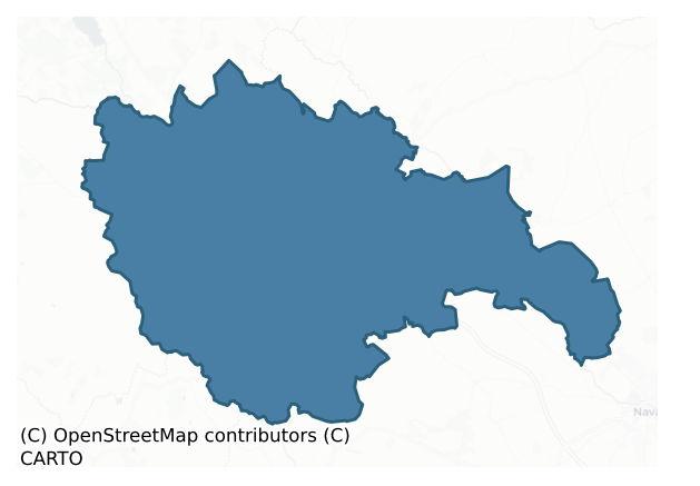
Kells Upper is a barony of County Meath, in the historical province of Leinster (Irish: Ceanannas Uachtarach), covering 200 km² of land. The barony records 413 NMS archaeological sites and 145 NIAH listed buildings, placing it at around the 57th percentile among 280 ROI baronies for sites per km². This means it is in the upper half of all baronies for sites per km². Dated archaeological evidence runs from the Neolithic through to the Modern, spanning 7 of 9 archaeological periods, placing the barony in the 32nd percentile among 280 ROI baronies for chronological depth. This means it is in the bottom third of all baronies for chronological depth. The largest dated subset of recorded sites dates to the Early Medieval. Logainm flags 22 placenames in the barony as carrying a recognised heritage root; the largest share — around 50% — are names associated with early Christian church and monastic foundations.
Heritage at a glance
Percentile rankings throughout this profile compare each barony only against the other 279 Republic of Ireland baronies.
The recorded heritage of Kells Upper
The National Monuments Service Sites and Monuments Record (SMR) is the statutory inventory of archaeological sites for the Republic of Ireland, maintained by the Department of Tourism, Culture, Arts, Gaeltacht, Sport and Media. Sites recorded here include earthworks, ringforts, megalithic tombs, ecclesiastical remains, and post-medieval features; not every record is legally protected, but each is registered as a monument of archaeological interest.
The National Monuments Service records 413 archaeological sites in Kells Upper, putting it at the 57th percentile among 280 ROI baronies for sites per km². This means it is in the upper half of all baronies for sites per km². Of these, 285 (69%) fall within a recorded monument protection zone. The record is dominated by defensive sites — ringforts, enclosures, hillforts, and stone forts (113 sites, 27% of the total), with agricultural and prehistoric industrial sites forming a substantial secondary presence (50 sites, 12%). Ringfort – rath is the most prevalent type, making up 15% of the barony's recorded sites (63 records), broadly in line with the ROI average of 20% across all baronies where this type occurs. Ringfort – rath is an earthen ringfort enclosed by a bank and external ditch — the most common Early Medieval farmstead, broadly dated 500–1000 AD. Other significant types include Fulacht fia (30) and Enclosure (22). Fulacht fia is a horseshoe-shaped Bronze Age burnt mound built around a sunken trough beside a water source, traditionally interpreted as a cooking site; Enclosure is a banked or ditched feature of uncertain type, used as a catch-all where the original function cannot be determined from surface evidence. Across the barony's 200 km², this gives a recorded density of 2.06 sites per km².
Most common monument types
Hover or tap a monument type to see its definition.
| Type | Count |
|---|---|
| Ringfort – rath an earthen ringfort enclosed by a bank and external ditch — the most common Early Medieval farmstead, broadly dated 500–1000 AD | 63 |
| Fulacht fia a horseshoe-shaped Bronze Age burnt mound built around a sunken trough beside a water source, traditionally interpreted as a cooking site | 30 |
| Enclosure a banked or ditched feature of uncertain type, used as a catch-all where the original function cannot be determined from surface evidence | 22 |
| Excavation – miscellaneous | 15 |
| Church a building used for public Christian worship, of any date from c. 500 AD onwards | 14 |
| Graveyard a burial area associated with a church, in use from the medieval period onwards | 13 |
| Ring-ditch a circular ditch under 20m across, often the ploughed-out remains of a barrow, ring-barrow or roundhouse | 13 |
Chronological distribution
The dated archaeological record for Kells Upper spans from the Neolithic through to the Modern, with activity attested across 7 of 9 archaeological periods. The record is near-continuous, with only the Post Medieval period falling inside the span without any recorded sites. Activity concentrates most heavily in the Early Medieval (78 sites, 29% of dated material), with the Iron Age forming a secondary peak (73 sites, 27%). A further 142 recorded sites (34% of the overall NMS register for the barony) carry no period attribution — appearing as 'Unknown' in the bar chart below. This typically reflects either records that pre-date the standardised period vocabulary or sites awaiting specialist dating review, rather than a genuine absence of chronological evidence.
Sample of recorded monuments
Show 25 sample monuments (of 413 total)
A representative sample of 25 recorded monuments drawn from the barony’s 413 total NMS entries. Sites within a recorded monument protection zone and rarer site types are prioritised so the list shows a meaningful cross-section rather than only the most common type. Each entry shows the official Sites and Monuments Record reference number and the description published by the National Monuments Service.
Passage tomb art
Described by Eogan (2000) as follows: ‘According to Conwell (1873, 14) a mound existed at this site up to a few years previously when it was removed by the land owner and the material spread over the field as top…
Described by Eogan (2000) as follows: ‘According to Conwell (1873, 14) a mound existed at this site up to a few years previously when it was removed by the land owner and the material spread over the field as top dressing. This implies that the mound was of earth. The stone was in the centre of the mound and it is stated that it covered a chamber that was constructed from flag stones; these were smaller than the decorated stone. However, the size and shape of the decorated stone suggests that it was an orthostat rather than a capstone.
To-day the decorated surface faces in a southerly direction, but as the stone has been re-erected, its original orientation is not known, nor can it be assumed that it was re-erected the correct way up. The chamber contained bones “all of which have disappeared”. The stone, rectangular in cross-section, is slightly over 2m in height and measures 0.85m in length at the base. The material is sandstone, the surface being uneven and flaked in places. Professor Phillips reports that “this stone is composed of well sorted cross-bedded quartz sandstone with a few circular calcareous concretions. This rock is of Lower Carboniferous age and could have been quarried in the Oldcastle area to the west.” The decoration is confined to the lower half of one of the two broad faces where it occupies virtually the entire surface. The motifs consist almost entirely of spirals. These are six in number. The bottom two are anti-clockwise; the remainder are clo…
Megalithic tomb – passage tomb
This has been described by Eogan (2000, 11-13) as follows: ‘This is also situated on a knoll and is very overgrown. The knoll, which is much higher than the adjacent features, is rounded and somewhat pudding-bowl in…
This has been described by Eogan (2000, 11-13) as follows: ‘This is also situated on a knoll and is very overgrown. The knoll, which is much higher than the adjacent features, is rounded and somewhat pudding-bowl in shape, and as such it contrasts with the other knolls in the area which are long Bakers. In Prof. Phillips' opinion it is "probably a kame deposited in a lake by melt water flowing out from a glacier during the last ice age c. 22,000-14,000 years ago." The view is slightly more extensive than that from Site 2 [ME010-044—-] and portions of Slieve na Calliagh range are visible. This almost circular monument, 26 by 25m in external diameter, has thirty-seven stones, thirty-one being in their original positions. If the gaps are filled, then about nineteen stones are missing, and this would have made a total of about fifty-six stones. Externally, 7m to the south-west, there is an isolated stone (No. 12a). This may have been a removed kerbstone. Internally there is a somewhat curved depression towards the centre. Within it, or close to it, are four stones in a disturbed position (Nos. A-D). Apart from No. A, these are not sufficiently large to have served as orthostats or capstones, so their function has not been established. However, it is possible that this might be the chamber area. The other portions within the circle have a spread of smallish stones, possibly lm or so in height. There are also some smaller stones outside the kerb. No art is visible. Professor P…
Barrow – unclassified
Situated on a rise in a low-lying landscape with a canalised WSW-ENE stream immediately outside it SE-SW. This is a subcircular grass-covered platform (dims 35m NE-SW; 30m NW-SE) defined by a scarp (at NE: Wth 7m; H…
Situated on a rise in a low-lying landscape with a canalised WSW-ENE stream immediately outside it SE-SW. This is a subcircular grass-covered platform (dims 35m NE-SW; 30m NW-SE) defined by a scarp (at NE: Wth 7m; H 1.2m; at SW: Wth 6m; H 0.8m) and an outer fosse (at SW: Wth of top 10m; ext. D 0.4m) S-W with a wide outer bank (at SW: Wth of base 13m; Wth of top 7m; ext. H 0.5m) and second external fosse (Wth of top 6m; Wth of base 2m; ext. D 0.3m) S-W. A dip (Wth of base 2.5m) in the inner scarp at SE is probably the original entrance.
The above description is derived from the published 'Archaeological Inventory of County Meath' (Dublin: Stationery Office, 1987). In certain instances the entries have been revised and updated in the light of recent research.
Compiled by: Michael Moore
Date of revision: 25 February 2019
Amended: 3 March 2023
Linear earthwork
Situated on a slight S-facing slope. It is depicted as a linear hachured feature (L c. 150m) forming the townland boundary between Ballynamona to the W and Mountainpole to the E only on the 1912 edition of the OS 6-inch…
Situated on a slight S-facing slope. It is depicted as a linear hachured feature (L c. 150m) forming the townland boundary between Ballynamona to the W and Mountainpole to the E only on the 1912 edition of the OS 6-inch map. It is on the N side of a minor E-W road, but it may have extended S of that road to the W-E River Blackwater (L c. 350m). North of the road it survives as a fosse (at S: Wth of top 8.7m; D at E: 1.6m) on the E side of an overgrown earthen bank (at S: Wth of base 6m; H at E c. 1.5m; H at W c. 2m). A field bank occupies the base of the fosse and the earthworks decrease in scale as they proceed N.Archaeological testing (05E0558) by E. Halpin and C. Farrimond immediately to the W on the S side of the road produced no related material (excavatioins.ie 2005:1234). (O’Connell 1969, 448)
O’Connell, P. 1969 The topography of the Lough Ramor region. Part II. Breifne, vol. 3, No. 12, 443-80.
The above description is derived from the published 'Archaeological Inventory of County Meath' (Dublin: Stationery Office, 1987). In certain instances the entries have been revised and updated in the light of recent research.
Compiled by: Michael Moore
Date of revision: 25 February 2019
Amended: 29 January 2021
Castle – tower house
A castle at Kilskyre (53) in Kilskyre parish and Kells barony is marked as a tower on the Down Survey (1656-8) barony and parish maps adjacent to the church (http://downsurvey.tcd.ie/). According to the Civil Survey…
A castle at Kilskyre (53) in Kilskyre parish and Kells barony is marked as a tower on the Down Survey (1656-8) barony and parish maps adjacent to the church (http://downsurvey.tcd.ie/). According to the Civil Survey (1654-6) the Earl of Fingal and Henry Plunkett of Hartstown in Killallon parish owned 325 acres at Kilskyre, Villenaghtownme, Millstowne and Cullinstowne, which are all sub-denominations of Kilskyre, in 1640 (Simington 1940, 301). It is situated on a slight rise in a fairly level landscape within the ecclesiastical enclosure (ME016-043005-) and c. 30m SW of the parish church (ME016-044—-). Only the ivy-covered NW corner of what was once probably a tower house survives to three storeys with no identifiable architectural features.
The above description is derived from the published 'Archaeological Inventory of County Meath' (Dublin: Stationery Office, 1987). In certain instances the entries have been revised and updated in the light of recent research.
Compiled by: Michael Moore
Date of revision: 27 February 2019
Hillfort
Situated on top of a prominent hill c. 1.5km WNW of the monastery of Cenannas or Kells (ME017-033—-) and overlooking a W-E section of the River Blackwater that is c. 700m to the N. An inland lighthouse was constructed…
Situated on top of a prominent hill c. 1.5km WNW of the monastery of Cenannas or Kells (ME017-033—-) and overlooking a W-E section of the River Blackwater that is c. 700m to the N. An inland lighthouse was constructed on the hill in 1791 (Carr 2000) and the two or three low but visible earthwork banks on the hill (Newman 1997, 201) are concentric with each other, although not centred on this tower, and are late landscape features. Geophysical survey was undertaken on the hill in 2013 by the Discovery Programme as part of the ‘Late Iron Age and “Roman” Ireland’ project and demonstrated that the central feature is certainly modern (Dowling 2015b, 11-16). The survey identified an innermost summit enclosure defined by two ditch features (ext. diam. c. 120m) accompanied by inner banks with a possible burnt palisade trench inside the inner bank and an entrance gap through the three features at E. About 70-80m outside the summit enclosure the outermost visible earthwork is obscuring at least two earlier fosse features, the line of which incorporates the curved field boundary S-NNW, creating an outer enclosure (diam. c. 250m). Some uncertain ring-ditches were recorded between the two enclosing groups of features. One enclosure (diam. c. 22m) is defined by an interrupted fosse feature and is situated E of the entrance in the summit enclosure. An earlier test excavation (03E1778) produced evidence of what might be a pit or a ditch associated with the summit enclosure, which provid…
Bridge
This bridge spans a NW-SE section of the River Blackwater. The bridge, known as Mabe’s Bridge, or Mapes or Malpas (Simington and O’Keefe 1991, 119) carries the R164 road from Kells to Moynalty and Kingscourt, Co. Cavan.…
This bridge spans a NW-SE section of the River Blackwater. The bridge, known as Mabe’s Bridge, or Mapes or Malpas (Simington and O’Keefe 1991, 119) carries the R164 road from Kells to Moynalty and Kingscourt, Co. Cavan. It is depicted on the Down Survey (1656-8) county and barony maps, and its name derives from the Mape family who held land at Maperath in Moynalty parish into the seventeenth century (Simington 1940, 305). The bridge has six arches and was expanded in width twice, from the SE (Wth 2m), to the central (Wth 1.2m), and NW (Wth 3m) sections. The last expansion probably took place in 1803 when major works were undertaken (ibid.). The parapet is level and there are no refuges. Repairs to the bridge in 1988 allowed a thorough survey to be undertaken when it was found to be partly built on bedrock. The central portion was built partly on the cut-waters of the original bridge and the down-river arches lack dressed stonework (ibid. 120-1).
The above description is derived from the published 'Archaeological Inventory of County Meath' (Dublin: Stationery Office, 1987). In certain instances the entries have been revised and updated in the light of recent research.
Compiled by: Michael Moore
Date of revision: 12 April 2019
Religious house – Fratres Cruciferi
The foundation of a priory of Knights Hospitallers of St. John has been attributed to Walter de Lacy in the late 12th century (O’Connell 1957, 20-1; 1960, 17-18), but the Hospital of St. John the Baptist at Kells was a…
The foundation of a priory of Knights Hospitallers of St. John has been attributed to Walter de Lacy in the late 12th century (O’Connell 1957, 20-1; 1960, 17-18), but the Hospital of St. John the Baptist at Kells was a house of the Fratres Cruciferi or Crutched Friars (Gwynn and Hadcock 1970, 213). This house is easily confused with the Hospitallers’ grange at Kilmainhambeg, now Kilmainhamwood (ME005-028—-). At its suppression in 1540 only the church of St. John was extant, the other buildings having been thrown down, but there was 74 acres of demesne including a water-mill, and other properties around Kells (White 1943, 264-5). It was situated outside the town on the Dublin road, at the bottom of the E-facing slope. There are no visible remains of a church in a rectangular graveyard (dims c. 45m E-W; c. 30m N-S) defined by masonry walls. There is a cross-slab, a 13th-century effigy of a woman, and a large fragment of a graveslab in the graveyard. Archaeological monitoring (02E1244) of the construction of a new wall at the S and W of the graveyard demonstrated that the wall was built on bedrock (D c. 0.6m) at S (Meenan 2004). A full survey of the graveyard inscriptions has been undertaken (Mc Cabe 2007).
The above description is derived from the published 'Archaeological Inventory of County Meath' (Dublin: Stationery Office, 1987). In certain instances the entries have been revised and updated in the light of recent research.
Compiled by: Michael Moore
Date of u…
House – 16th/17th century
Land at Kilmainhambeg in Kells parish was a grange or out-farm of the Knights Hospitallers of St James at Kilmainham in Dublin (DU018-020285-), which is not to be confused with their preceptory at Kilmainhamwood…
Land at Kilmainhambeg in Kells parish was a grange or out-farm of the Knights Hospitallers of St James at Kilmainham in Dublin (DU018-020285-), which is not to be confused with their preceptory at Kilmainhamwood (ME005-028—-). The grange was surrendered in 1541 (White 1943, 111-2), but the precise location of its caput or centre is not known, although it could be at this location. A gabled house at Kilmainham (88) is depicted on the Down Survey barony and parish maps of Telltown parish in Kells barony and in this vicinity (http://downsurvey.tcd.ie/). According to the terrier (commentary) of the map Nicholas Barnwall of Turvey, Richard Ledwitch of Cookstown, Robert Beg of Navan, and Patrick Barnwall of Beymore owned the entire townland, but according to the Civil Survey (1654-6) they owned only 248 acres there in 1640 and the house is not mentioned in either document (Simington 1940, 297). It is described as an ‘Old Castle’ in gothic script on the 1835 ed. of the OS 6-inch map. It is situated on the flood-plain of the River Blackwater c. 240m SW of where the river turns from N-S to W-E.
Two opposed corners of a building (ext. dims c. 9m NE-SW; c. 8.2m NW-SE) survive separated by the NE-SW demesne wall of Headford, with a corner fireplace at the W angle and evidence of a doorway on the SE wall close to the E angle at the ground floor. The walls are rebated for the first and second floors, and there is evidence of a window embrasure on the SE wall at the first floor. A pa…
Town defences
The town defences of Kells enclosed an area of c. 20 ha (c. 52 acres) and had a circumference of 1.8 km. The date of construction is uncertain but the earliest murage grant was in 1326 (Simms and Simms 1990, 2). In 1462…
The town defences of Kells enclosed an area of c. 20 ha (c. 52 acres) and had a circumference of 1.8 km. The date of construction is uncertain but the earliest murage grant was in 1326 (Simms and Simms 1990, 2). In 1462 Parliament agreed to continue an existing murage grant (Berry 1914, 25). The walls were maintained into the 17th century and were scaled by Catholic Confederate troops when they captured the town in 1647. The walls were described as ruined in the Civil Survey (1654-6) but the Down Survey (1656-8) noted that Kells had a stone wall with five gates: Canon Gate, Carrick Gate at the N end of the Fair Green, Maudlin Gate, Dublin Gate on Headford Place, and Trim Gate on Bective Street.
Apart from one mural tower there are no upstanding remains of the medieval defences, although its line can be deduced from the Down Survey maps and a valuation of the town in 1663 (Simington 1960, 267-8). The line ran from the mural tower S of Canon Street westwards along the back of properties on the S side of that street to Canon Gate, but testing (01E0979) at this angle has failed to produce any evidence of it (Shanahan 2003). The wall turned N along the E side of the Fair Green to Carrick Gate. The wall is thought to have followed the back of properties on the N side of Carrick Street to Maudlin Gate on the eponymous street, but archaeological testing (01E1145) has so far failed to confirm this (Hayden 2006). It ran to the E of properties on the E side of Castle Street and co…
Historic town
Located on the summit of and on the N, E and S-facing slopes of a low hill on the E side of the Hill of Lloyd. Numerous prehistoric artefacts have been found within the town and it may have been an important prehistoric…
Located on the summit of and on the N, E and S-facing slopes of a low hill on the E side of the Hill of Lloyd. Numerous prehistoric artefacts have been found within the town and it may have been an important prehistoric centre before it became a Christian one (Bradley and King 1985, 70). It was reputed to be a stronghold of Diarmait Mac Cerbhill, King of the southern Uí Néill who died in AD 565, and it was known as Cenannas na Rí defended by a múr or wall in Old and Middle Irish tales. Ceanannas means ‘white-headed’ or pale (Simms and Simms 1990, 1), and a rath (ME017-044028-) at least was probably present before the Columban monastery was established (ME017-044012-).
When the monastic community of Iona left St Columba’s original monastery after some of the earliest Viking raids recorded in Britain or Ireland c. 800 AD they set up at Ceanannas. The templum or principal church was built by 814, and the relics of the saint were brought here ultimately, although they might also have spent time at Screen (ME032-047003-). Its most precious relic was the richly illuminated Book of Kells, which was probably produced in Iona c. 800 but during the later middle ages it was kept on the altar of the parish church (ME017-044031-) until 1653 when it made its way to Dublin and ultimately to the Royal Irish Academy (Simington 1960, 241-2). In addition to the original Gospels it records some pre-Anglo-Norman charters for parcels of the monastery’s lands. The size and prosperity of the ne…
Megalithic tomb – unclassified
Situated on a fairly level landscape and on the demesne of Drewstown House, which is c. 850m to the SW. A large stone (max. dims c. 3.25m x c. 1.42m; T c. 0.6m) was described (Adams 1958, 55-6) as lying separate from…
Situated on a fairly level landscape and on the demesne of Drewstown House, which is c. 850m to the SW. A large stone (max. dims c. 3.25m x c. 1.42m; T c. 0.6m) was described (Adams 1958, 55-6) as lying separate from and probably to the NW of a large roofstone (dims c. 3.95m x c. 2.64m; T 0.75m) that was supported on two or three stones, one of which was broken. The tomb had been briefly described but not drawn by the antiquarian Austin Cooper c. 1790 (Price 1942, 125), and it was removed in land reclamation c. 1964. Herity (1974, 244) lists it amongst the passage tombs of Co. Meath.
The above description is derived from the published 'Archaeological Inventory of County Meath' (Dublin: Stationery Office, 1987). In certain instances the entries have been revised and updated in the light of recent research.
Compiled by: Michael Moore
Date of revision: 27 February 2019
Barrow – stepped barrow
Situated on a fairly level landscape with a small E-W canalised stream to the S. This feature is not depicted on any map but is visible on aerial photographs (ACAP: 306/ 1363, 1364), and on some later images (Digital…
Situated on a fairly level landscape with a small E-W canalised stream to the S. This feature is not depicted on any map but is visible on aerial photographs (ACAP: 306/ 1363, 1364), and on some later images (Digital Globe; OSAP (2017); Google Earth 18/06/2017). This consists of a low grass-covered mound (diam. 54.3m N-S; 51.3m E-W; H 1.4m) separated by a berm (Wth 4.8-6m) from a low earthen bank (at SSE: Wth of base 8m; int. H 0.4m; ext. H 1m) ESE-SSE that is largely reduced to a scarp (H 1m) (max. ext. diam. 72m).
The above description is derived from the published 'Archaeological Inventory of County Meath' (Dublin: Stationery Office, 1987). In certain instances the entries have been revised and updated in the light of recent research.
Compiled by: Michael Moore
Date of revision: 16 April 2019
Round tower
The round tower is SW of the present Church of Ireland church and the likely site of the daimhliag. It is now incorporated into the masonry wall of the graveyard (ME017-04434-). It was extant in 1076 as in that year…
The round tower is SW of the present Church of Ireland church and the likely site of the daimhliag. It is now incorporated into the masonry wall of the graveyard (ME017-04434-). It was extant in 1076 as in that year Murchadh O’Melaghlin, King of Tara, was murdered in it (Cogan 1862-70, 1, 41). It is constructed on a plinth resting on rock outcrop. The entrance doorway on the N side is 1.5m above the raised level of the graveyard and is round-arched and of sandstone. The tower (int. diam. 2.6m at the doorway) has five floors and has five pointed windows at the top. The conical cap is missing. (Barrow 1979, 168)
Compiled by: Michael Moore
Date of upload: 2 July, 2014
Stone head
From Bradley and King (1985, 1, 81) Stone heads Late 16th / 17th century. These are on the S wall of the church tower. O’Connell (1960, 22) says that these were found when the present church was being built. All are on…
From Bradley and King (1985, 1, 81) Stone heads Late 16th / 17th century. These are on the S wall of the church tower. O’Connell (1960, 22) says that these were found when the present church was being built. All are on square plaques of limestone. (a) Round face with short hair under a flat cap (Wth c. 0.46m). (b) Bishop with an elaborately embroidered mitre worn over short cropped hair with amice around the neck. (dims c. 0.3m). (C) Woman wearing a flat cap over short cropped hair (Wth c. 0.26m).
Compiled by: Michael Moore
Date of upload: 2 July, 2014
Ogham stone
An ogham stone (H c. 0.6m) was unearthed in the graveyard (ME016-006007-) of the early monastery of Diseart Chiarain (ME016-006—-) in 1898 and it is set up incorrectly with the top below. It is just N of the church…
An ogham stone (H c. 0.6m) was unearthed in the graveyard (ME016-006007-) of the early monastery of Diseart Chiarain (ME016-006—-) in 1898 and it is set up incorrectly with the top below. It is just N of the church remains, and has been read as: COVAGNI MAGI MUCOI LUGUNI (O'Connell 1957, 26; Macalister 1945, vol. 1, 46). However, a more recent interpretation (Heery and Newman Maguire 2012) has identified further letters and provides the reading: T_COVAGNI MAQI MUCOI LUGUNI ITI, and they suggest that the person commemorated is Segéne of Clara whose death is recorded in the Annals of Tigernach in 784.
Compiled by: Michael Moore
Date of revised upload; 6 June, 2014
Amended: 21 July 2022
Barrow – ditch barrow
Situated on relatively low ground with limited views. There is a knoll immediately to the NE and a second one c. 100m to the E. A circular grass-covered platform (diam. 17.3m N-S; 16.8m E-W) is surrounded by a clearly…
Situated on relatively low ground with limited views. There is a knoll immediately to the NE and a second one c. 100m to the E. A circular grass-covered platform (diam. 17.3m N-S; 16.8m E-W) is surrounded by a clearly visible U-shaped fosse (Wth of top c. 9m; Wth at base 3m; max. D c. 1m) except E-SSW where there is evidence for quarrying.
Compiled by: Claire Breen & Michael Moore
Date of revised upload: 26 February 2019
Decorated stone (present location)
The remains of this monument have been described by Eogan (2000, 7-9) as follows: ‘What survives to-day is a large flat stone and a rounded boulder, possibly an orthostat and kerb-stone. These are not in their original…
The remains of this monument have been described by Eogan (2000, 7-9) as follows: ‘What survives to-day is a large flat stone and a rounded boulder, possibly an orthostat and kerb-stone. These are not in their original position but were dumped there after destruction. There are some other stones in the area, but these are much smaller. The large decorated stone is at least probably one of the "large upright stones" referred to by Conwell. From local information, it appears that a monument stood very close to where the stones now are, but it is not possible to determine its precise location or the date of the removal, but this may have been about 1990. It was removed by bull-dozing; the two stones described in this paper were thrown aside and according to a local informant, a pit was dug into which other large stones were dumped. The area tends to slope to the south-east but adjoining ground to the north-west is higher.
Stone A is a large flag 2.40m long. At one end it is 1.35m in maximum width; at the other it is about 1m. It is 0.40m in average width. The material is carboniferous sandstone with round calcareous concretions. Two parallel grooves near the top left-hand corner were caused by the teeth of the bulldozer bucket. Decoration occurs on the broad face that is visible and on one of the narrow sides. There is no decoration on the other three narrow sides. The other broad face is lying on the ground, but as it has not been possible to have it lifted, it is not kno…
Slab-lined burial
Situated on a rise in an undulating landscape. A lintelled burial (dims 1.7m E-W; 0.5m N-S) lined with thin slabs set upright and covered by six lintels was discovered in removing topsoil for a driveway in 1988. It was…
Situated on a rise in an undulating landscape. A lintelled burial (dims 1.7m E-W; 0.5m N-S) lined with thin slabs set upright and covered by six lintels was discovered in removing topsoil for a driveway in 1988. It was excavated by Mary Cahill of the National Museum of Ireland assisted by Niall Brady, and the human remains were examined by Barra Ó Donnabháin. It had a W-E orientation and packing stones and support stones were also recorded. It contained the inhumed remains of a young adult female (age 18-25), and a sample yielded a calibrated C14 date of AD 430-670. While no other graves were recovered the recorded burial may be one of a cemetery. (Cahill 2011)
Compiled by: Michael Moore
Date of upload: 26 February 2019
Sheela-na-gig
Sheela-na-gig now lost that was described in 1857 by W. R. Wilde in the Royal Irish Academy Museum Catalogue as being in situ, ‘in the church (ME017-044031-) of Kells’ (Wilde 1857, 141; Guest 1936, 118; Freitag 2004,…
Sheela-na-gig now lost that was described in 1857 by W. R. Wilde in the Royal Irish Academy Museum Catalogue as being in situ, ‘in the church (ME017-044031-) of Kells’ (Wilde 1857, 141; Guest 1936, 118; Freitag 2004, 144).
Compiled by: Caimin O'Brien
Date of upload: 22 May 2012
Tomb – chest tomb
From King (1987, 295-6): Tomb chest. 1686. This monument for Hugh Reilly and his wife Catherine Plunkett is set against the north wall in the east end of the ruined church in Kilskeer graveyard. It consists of a…
From King (1987, 295-6): Tomb chest. 1686. This monument for Hugh Reilly and his wife Catherine Plunkett is set against the north wall in the east end of the ruined church in Kilskeer graveyard. It consists of a partially damaged tomb chest and wall plaques. The tomb cover is undecorated apart from the following incised inscription in Roman Capitals (missing letter are given in lower case): this monVMENT WAS ERE / cted for HUGH REILY OF / …EN IN THE COVNTY / of meaTH ESQ AND CATHRI/ N aliAS PLUNKET HIS WEI / f and THERE CHILDREN WHO / …DETH TO BE HEARE INTE / rred WITH THERE POSTERETY / the SAIDE MONVMENT BEING / finiSHED THE YEARE OF OUR loRD GOD 1686. The end panel is decorated with mortality symbols while the side panel has three figures in recessed niches. On the left side is a man with knees and arms bent, showing out-turned hands. The centre niche has a woman with out-turned feet and her hands flat on her chest, and on the right is a virtually naked figure with upraised hands. Above the tomb there are two wall plaques with irregularly displayed interpretations of the arms of the Plunkett and O’Reilly families. Dimensions of chest cover: L 2.02m; Wth 0.96m; T 0.08m.
(Cogan 1862-70, 1, 149; FitzGerald 1909, 650)
See the attached views of the armorial stones at the O'Reilly tomb (007), and the tomb surrounds (009) and (016).
Date of upload: 10 July, 2014
Burial Vault
Situated on a rise in a fairly level landscape with the small NNE-SSW Yellow River c. 80m to the W. There is an underground crypt or burial vault (int. dims 3m x 2.75m) in St. Anne's church (ME025-002001-) approached by…
Situated on a rise in a fairly level landscape with the small NNE-SSW Yellow River c. 80m to the W. There is an underground crypt or burial vault (int. dims 3m x 2.75m) in St. Anne's church (ME025-002001-) approached by steps from the E (Kelly 1973, 8).
Compiled by: Michael Moore
Date of upload: 27 June, 2014
Religious house – Augustinian canons
A house of Augustinians dedicated to St. Mary was established 1140-8 at Kells at the suggestion of St Malachy, and it may have been a double monastery of canons and nuns since it was described as a dependency of the…
A house of Augustinians dedicated to St. Mary was established 1140-8 at Kells at the suggestion of St Malachy, and it may have been a double monastery of canons and nuns since it was described as a dependency of the Arroasian house at Clonard in 1195. The abbey may have been destroyed by the campaigns of Dermot MacMurrough in 1171 or the Anglo-Normans in 1176 since it was re-founded by Hugh de Lacy before 1186 and its charter was confirmed by Richard II at Drogheda in 1395. The charters list extensive lands in counties Meath, Cavan, Louth, Kildare, Leitrim and Fermanagh, and most of the churches of Kilmore diocese were impropriate to the abbey. The canons seem to have been largely Irish throughout its history and to have a close connection with Kilmore diocese, providing its bishop in 1286. In 1409 indulgences were granted as the buildings were in a state of disrepair. In 1420 Pope Martin V appointed John Oraghillich (O’Reilly), ‘a canon of Cruczelingen outside the walls of Constance’ as abbot but he proved to be too radical and was deposed in 1444 to be succeeded by John O’Reilly who was translated to the See of Kilmore in 1465. The abbey was suppressed in 1539 when Richard Plunkett was abbot, and he and two canons received pensions. (Gwynn and Hadcock 1970, 181; Bradley and King 1985, 82-3)
At the Suppression the church was being used as a granary, and in addition there were three chambers and a steward’s room, all occupied by the farmer, William Dormor (White 1943, 2…
Cross – High cross (present location)
The cross known as the Market Cross (ME017-044001-) was situated at the junction of Market St. and Castle St., on the perimeter of the ecclesiastical enclosure (ME017-044025-) defining the monastic site of Ceanannus.…
The cross known as the Market Cross (ME017-044001-) was situated at the junction of Market St. and Castle St., on the perimeter of the ecclesiastical enclosure (ME017-044025-) defining the monastic site of Ceanannus. However, it is not known if this was its original location since an inscription on the shaft says it was erected by Robert (Ba)lfe in 1688. Nevertheless Swan (1998) avers that it is a termon or boundary cross in its original position on the perimeter of the monastery. The cross was moved to its present position in front of the Court House between the Dublin and Headford roads in 2001 (King 2004; 2006) and erected correctly with what had been the S face now facing E. The Court House has been converted into an interpretive centre for the history of the town, but it is currently closed for conservation works.
Even the lesser sides of the shaft of this ringed cross have decorated panels, and it can be dated to the 10th century. The cross (H 2.75m; Wth 1.65m) has a shaft (dims 0.53m x 0.37m) with damaged roll-moulding set in a pyramidal base (dims at base 1.34m x 1.25m; H 0.6m) decorated with hunting and riding scenes.
The panels are listed from the bottom as correctly displayed in its present position. The N face has the betrayal of Judas, Peter cuts off an ear, and the flagellation of Christ. The S face has an unidentified scene, the judgement of Solomon, Samuel anointing David, and the pillar of fire. The E face has a panel of spirals, Christ in the tomb, Dav…
Ringfort – rath
Situated on a hillock. A circular embanked enclosure is depicted only on the 1912 edition of the OS 6-inch map within a small wood. A small fragment of an earthen bank (Wth of base 2.8m; int. H c. 0.8m; ext. H 1.3m) and…
Situated on a hillock. A circular embanked enclosure is depicted only on the 1912 edition of the OS 6-inch map within a small wood. A small fragment of an earthen bank (Wth of base 2.8m; int. H c. 0.8m; ext. H 1.3m) and an outer fosse (Wth of base 1.4m; ext. D 0.5m) at the NW edge of an enclosure survived in 1968 (SRM file), the rest having been quarried away (O’Connell 1958, 17). It is absorbed within a farm complex since 2000 (OSAP).
The above description is derived from the published 'Archaeological Inventory of County Meath' (Dublin: Stationery Office, 1987). In certain instances the entries have been revised and updated in the light of recent research.
Compiled by: Michael Moore
Date of revision: 22 February 2019
Listed buildings
The National Inventory of Architectural Heritage (NIAH) is a state survey appraising buildings of architectural, historical, archaeological, artistic, cultural, scientific, social, or technical interest. Each surveyed structure receives a rating from International (the highest, for buildings of European importance) through National, Regional, Local, and Record-Only.
The NIAH records 145 listed buildings in Kells Upper (66th percentile across ROI baronies). All recorded buildings carry Regional or lower grading; the barony does not contain any structures appraised as being of National or International architectural importance. Construction dates concentrate most heavily in the Victorian (1830-1900) period. The most-recorded building type is house (52 examples, 36% of the listed stock).
Terrain and environment
Mean elevation across the barony is 81m — the 42nd percentile among 280 ROI baronies for elevation. This means it is in the lower half of all baronies for elevation. Elevation matters for heritage because higher-altitude baronies typically favour defensive monuments — ringforts and hilltop forts placed on prominent ground — while lowland baronies are more likely to carry the dense settlement and church networks of intensive agricultural landscapes. A maximum elevation of 194m gives the barony meaningful vertical relief. Mean slope is 2.7° — the 30th percentile among 280 ROI baronies for slope. This means it is in the bottom third of all baronies for slope. Slope is a key control on both land use and archaeological preservation: steep ground resists ploughing and tends to preserve earthworks intact, while gentle slopes favour intensive cultivation that damages or destroys surface archaeology over time. The Topographic Wetness Index averages 11.2, the 66th percentile among 280 ROI baronies for wetness. This means it is in the upper half of all baronies for wetness. Drainage matters for heritage because poorly-drained ground preserves organic archaeology (wooden trackways, leather, textiles, and on rare occasions human remains) far better than free-draining soil; well-drained ground favours arable use but destroys organic material rapidly. The land-cover mosaic combines improved grassland (79%), arable farmland (10%), and woodland (9%), giving a mixed agricultural and semi-natural landscape.
Terrain measurements
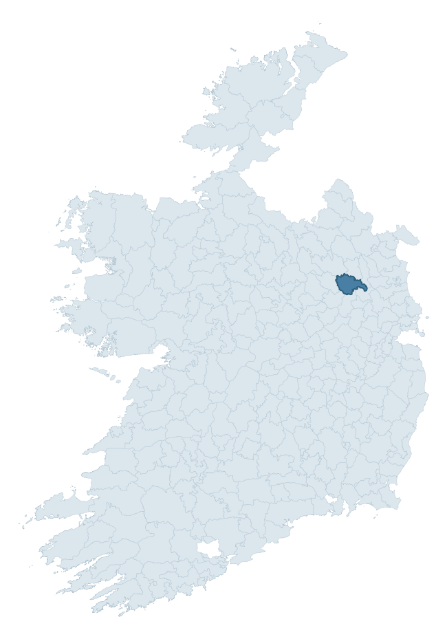
Where this barony sits in the Republic of Ireland
Geology and preservation
Bedrock geology shapes the landscape long before any settlement begins — controlling soil drainage, agricultural potential, the survival of upstanding monuments, and the preservation of buried archaeology. The figures below come from the Geological Survey Ireland 1:100,000 bedrock map.
The bedrock underlying Kells Upper is predominantly greywacke (44% of the barony by area), laid down during the Carboniferous period (51% by area, around 359 to 299 million years ago). Greywacke is a hard, dark, fine-grained sandstone that weathers to thin upland soils. Greywacke baronies typically carry sparser settlement archaeology but provide high-quality building stone visible in older field walls and farm buildings. A substantial secondary geology of limestone (43%) adds further variety to the underlying landscape. The single largest mapped unit is the Clontail Formation (44% of the barony's bedrock). With 8 distinct rock types mapped, the barony sits in the top third of ROI baronies for geological diversity (77th percentile) — typically a sign of complex tectonic history or coastal mosaics of differing rock units.
Rock type composition
Largest mapped unit: Clontail Formation (44% of the barony)
Placename evidence
Logainm records 22 heritage-diagnostic placenames for Kells Upper, drawn from townland and civil-parish names across the barony. The dominant stratum is Early Christian ecclesiastical — cill-, teampall-, and domhnach-prefixed names that record the dense network of early church foundations established between the fifth and tenth centuries. The leading diagnostic roots are ráth- (8 — earthen ringfort), cill- (6 — church), and domhnach- (2 — very early church). This is below the ROI average of 30.7 heritage placenames per barony, suggesting either lighter survey coverage or a townland-naming tradition that draws more on generic landscape vocabulary. The presence of multiple heritage strata side by side indicates layered occupation of the landscape across successive prehistoric and historic periods. Logainm records 137 placenames for Kells Upper (predominantly townland names). Of these, 22 (16%) carry one of the diagnostic Gaelic roots tracked above; the remainder draw on more generic landscape vocabulary that does not encode a heritage period.
Pre-Christian / Early Medieval Defensive
| Root | Count | Meaning |
|---|---|---|
| ráth- | 8 | earthen ringfort |
| lios- | 1 | ringfort or enclosure |
Early Christian Ecclesiastical
| Root | Count | Meaning |
|---|---|---|
| cill- | 6 | church (early) |
| domhnach- | 2 | pre-Patrician or earliest Patrician church |
| gráinseach- | 2 | monastic farm / grange |
| díseart- | 1 | hermitage |
Burial, Ritual, and Norse-Contact
| Root | Count | Meaning |
|---|---|---|
| carn- | 2 | cairn |
Other baronies in Meath
About this profile
Click any section below to expand.
What is a barony?
A barony is a historic administrative unit in Ireland, broadly equivalent to an English hundred. The 280 baronies used here are from the OSi 2019 National Statutory Boundaries (generalised 20m), covering the 26 counties of the Republic of Ireland. Baronies derive from the Norman period, were formalised in the 17th century, and have not been redrawn for statistical purposes. They vary enormously in area, from compact urban baronies in Dublin to vast upland baronies in Connacht, and should not be compared by raw site count without accounting for area differences.
What counts as a site?
This profile combines three distinct heritage registers, each with its own definition of what constitutes a recordable site:
- Archaeological sites (NMS). The National Monuments Service Sites and Monuments Record (SMR) catalogues every known archaeological monument or site of archaeological interest in the Republic, from prehistoric burial mounds and ringforts to medieval churches and post-medieval defensive works. Inclusion does not require legal protection — only that the site has been identified, surveyed, and assessed as having archaeological value. A separate subset of these sites lies within a recorded protection zone, which gives them statutory protection under the National Monuments Acts.
- Listed buildings (NIAH). The National Inventory of Architectural Heritage records buildings of architectural, historical, archaeological, artistic, cultural, scientific, social, or technical interest. Each surveyed structure is appraised on a five-tier scale: International, National, Regional, Local, and Record-Only. The NIAH appraisal is informational rather than strictly statutory, but it underpins local-authority Record of Protected Structures (RPS) listings.
- Heritage placenames (Logainm). Logainm is the authoritative database of Irish placenames maintained by the Placenames Branch. This profile applies a heritage-diagnostic classifier to the Irish-language form of each townland name, flagging roots that signal defensive sites (ráth-, lios-, dún-, caiseal-, cathair-), ecclesiastical foundations (cill-, teampall-, domhnach-, mainistir-), prehistoric burial-ritual features (tuaim-, carn-, leaba-), or Norse-contact settlement (gall-). Townlands without one of these diagnostic roots are not flagged here — they may still carry historical significance, but that significance is not encoded in the name itself.
Editorial principles
The narrative sections of this profile follow several explicit principles:
- Evidential. Every claim about this barony’s heritage character is anchored in the underlying register data. Where a site count, a placename count, or a percentile rank is cited, it is computed from the source datasets at export time, not estimated.
- Comparative. Counts and metrics are reported alongside their percentile rank against the other 279 ROI baronies. A barony with 50 ringforts in absolute terms could be unusually high or unusually low depending on its size and regional context; percentile ranking removes that ambiguity.
- Transparent on limits. Where a register has known coverage gaps, survey biases, or data-quality issues that affect this barony’s figures, the profile flags them rather than presenting the numbers as definitive.
- No interpretation beyond what the data supports. The narrative does not speculate about historical events, social dynamics, or cultural meaning beyond what the recorded heritage and placename evidence directly attests.
Data caveats and limits
- NMS Sites and Monuments Record is the product of survey campaigns conducted at different intensities across different counties and decades. Some baronies have been surveyed more thoroughly than others, and absolute counts should be read in that light. Sites destroyed by development before survey are typically not represented; sites in heavily forested or upland terrain are sometimes under-recorded.
- NIAH coverage is broadly complete for the Republic of Ireland but the survey was conducted on a rolling county-by-county basis, and the most recent appraisal date varies. Buildings demolished or substantially altered after their original survey may still appear in the register; conversely, recent buildings of merit may not yet have been appraised.
- Logainm classification applies a deliberately conservative pattern-matching approach to the Irish-language townland forms. The classifier prioritises true positives over recall: a townland may carry a heritage signal that the classifier doesn’t recognise, particularly where the diagnostic root has been heavily anglicised or where the townland name draws on a less common term. The 60,000+ townland records and ~9,800 classified placenames give a substantial signal at barony scale, but individual townland names should be checked against Logainm directly for definitive interpretation.
- Period attribution. The chronological distribution reflects only those NMS sites that carry a recognised period attribution in the source data. Sites listed as “Unknown” period are excluded from the dated subset.
- Boundary changes. Some baronies have undergone minor boundary adjustments since their 19th-century definition; the OSi 2019 generalised boundaries used here are the current statutory definition and may differ slightly from historical maps in border areas.
- Bedrock geology is mapped at 1:100,000 scale, which means local variation within a barony — small pockets of different rock type, mineral veins, alluvium overlying bedrock — is generalised. The dominant-system and rocktype figures are area-weighted, so a barony reading “70% Carboniferous limestone” may still contain small but archaeologically important pockets of older or younger rock. Around 3% of GSI polygons do not match the lexicon and contribute no rocktype or system attribution.
Data sources
- National Monuments Service — Sites and Monuments Record (SMR) https://data.gov.ie/dataset/national-monuments-service-archaeological-survey-of-ireland
- National Inventory of Architectural Heritage (NIAH) https://data.gov.ie/dataset/national-inventory-of-architectural-heritage-niah-national-dataset
- Logainm — Placenames Database of Ireland https://www.logainm.ie/
- Ordnance Survey Ireland — National Statutory Barony Boundaries 2019 https://data-osi.opendata.arcgis.com/
- EURODEM — European Digital Elevation Model https://www.mapsforeurope.org/datasets/euro-dem
- ESA WorldCover https://esa-worldcover.org/en
- Geological Survey Ireland — 1:100,000 Bedrock Geology https://www.gsi.ie/en-ie/data-and-maps/Pages/Bedrock.aspx
Explore more: Search any of the 280 ROI baronies, browse by historical province, or read the methodology and data sources for the full Republic of Ireland Heritage Tool.