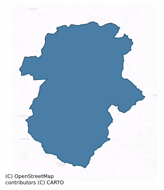
Moyfenrath Lower is a barony of County Meath, in the historical province of Leinster (Irish: Maigh Fionnráithe Íochtarach), covering 164 km² of land. The barony records 242 NMS archaeological sites and 78 NIAH listed buildings, placing it at around the 32nd percentile among 280 ROI baronies for sites per km². This means it is in the bottom third of all baronies for sites per km². Dated archaeological evidence runs from the Early Bronze Age through to the Modern, spanning 7 of 9 archaeological periods, placing the barony in the 37th percentile among 280 ROI baronies for chronological depth. This means it is in the lower half of all baronies for chronological depth. The largest dated subset of recorded sites dates to the Iron Age. Logainm flags 20 placenames in the barony as carrying a recognised heritage root; the largest share — around 60% — are names associated with pre-christian defensive.

Heritage at a glance
Percentile rankings throughout this profile compare each barony only against the other 279 Republic of Ireland baronies.
The recorded heritage of Moyfenrath Lower
The National Monuments Service Sites and Monuments Record (SMR) is the statutory inventory of archaeological sites for the Republic of Ireland, maintained by the Department of Tourism, Culture, Arts, Gaeltacht, Sport and Media. Sites recorded here include earthworks, ringforts, megalithic tombs, ecclesiastical remains, and post-medieval features; not every record is legally protected, but each is registered as a monument of archaeological interest.
The National Monuments Service records 242 archaeological sites in Moyfenrath Lower, putting it at the 32nd percentile among 280 ROI baronies for sites per km². This means it is in the bottom third of all baronies for sites per km². Protection coverage is near-universal — 224 sites (93%) fall within a recorded monument protection zone, indicating an extensively surveyed landscape. The record is dominated by defensive sites — ringforts, enclosures, hillforts, and stone forts (83 sites, 34% of the total), with burial and ritual monuments forming a substantial secondary presence (34 sites, 14%). Ringfort – rath is the most prevalent type, making up 15% of the barony's recorded sites (36 records), broadly in line with the ROI average of 20% across all baronies where this type occurs. Ringfort – rath is an earthen ringfort enclosed by a bank and external ditch — the most common Early Medieval farmstead, broadly dated 500–1000 AD. Other significant types include Enclosure (24) and Ring-ditch (16). Enclosure is a banked or ditched feature of uncertain type, used as a catch-all where the original function cannot be determined from surface evidence; Ring-ditch is a circular ditch under 20m across, often the ploughed-out remains of a barrow, ring-barrow or roundhouse. Across the barony's 164 km², this gives a recorded density of 1.48 sites per km².
Most common monument types
Hover or tap a monument type to see its definition.
| Type | Count |
|---|---|
| Ringfort – rath an earthen ringfort enclosed by a bank and external ditch — the most common Early Medieval farmstead, broadly dated 500–1000 AD | 36 |
| Enclosure a banked or ditched feature of uncertain type, used as a catch-all where the original function cannot be determined from surface evidence | 24 |
| Ring-ditch a circular ditch under 20m across, often the ploughed-out remains of a barrow, ring-barrow or roundhouse | 16 |
| Church a building used for public Christian worship, of any date from c. 500 AD onwards | 10 |
| Excavation – miscellaneous | 10 |
| Graveyard a burial area associated with a church, in use from the medieval period onwards | 9 |
| Burial ground an area set apart for burial that is not associated with a church, in use from the medieval period onwards | 8 |
Chronological distribution
The dated archaeological record for Moyfenrath Lower spans from the Early Bronze Age through to the Modern, with activity attested across 7 of 9 archaeological periods. Every period from earliest to latest is represented in the record — an unbroken sequence of dated activity across the full chronological span. Activity concentrates most heavily in the Iron Age (69 sites, 42% of dated material), with the Medieval forming a secondary peak (35 sites, 21%). A further 76 recorded sites (31% of the overall NMS register for the barony) carry no period attribution — appearing as 'Unknown' in the bar chart below. This typically reflects either records that pre-date the standardised period vocabulary or sites awaiting specialist dating review, rather than a genuine absence of chronological evidence.
Sample of recorded monuments
Show 25 sample monuments (of 242 total)
A representative sample of 25 recorded monuments drawn from the barony’s 242 total NMS entries. Sites within a recorded monument protection zone and rarer site types are prioritised so the list shows a meaningful cross-section rather than only the most common type. Each entry shows the official Sites and Monuments Record reference number and the description published by the National Monuments Service.
Gatehouse
Situated on a slight rise on the S bank of a W-E section of the River Boyne, with the stream c. 75m to the N. According to the Civil Survey (1654-6) Mary Newgent owned 199 acres at Newhaggard in Trim parish in 1640 and…
Situated on a slight rise on the S bank of a W-E section of the River Boyne, with the stream c. 75m to the N. According to the Civil Survey (1654-6) Mary Newgent owned 199 acres at Newhaggard in Trim parish in 1640 and on the premises were ‘one castle, two Mills, one weare with an orchard and some small cabins’ (Simington 1940, 169). An illustration by Austin Cooper c. 1785 shows it a ruined gateway with its passage open and two upper storeys (Price 1942, Pl. 43).
This is a rectangular structure (ext. dims 8.9m N-S; 8.1m E-W) with an entrance passage (Wth 2.55-3.34m) through it N-S, although both ends are closed off and provided with lintelled doorways. It was designed originally as a gateway, although there is no evidence of portcullis niches or rebates for gates. A flat-arched doorway towards the N end of the W external wall leads directly to a newel stairs that rises to the upper levels. A destroyed doorway from the stairs leads to the inserted first floor under the N-S barrel-vault, the floor being supported on joists set in the E and W walls, but this floor has no other features. At the second floor, over the vault, a destroyed doorway leads from the stairs to a square chamber with two windows on the E and S walls, and one on the N, but most of the W wall is destroyed. The pattern is repeated at the third floor with the joists for its floor set directly into the walls, but the parapet does not survive. All the windows are simple rectangles, apart from narrow light…
Religious house – Franciscan friars
A Franciscan friary was probably founded before 1287, but its early benefactors are not known for certain (Gwynn and Hadcock 1970, 260). The earliest assured reference is in 1318 when a dispute arose with the Dominicans…
A Franciscan friary was probably founded before 1287, but its early benefactors are not known for certain (Gwynn and Hadcock 1970, 260). The earliest assured reference is in 1318 when a dispute arose with the Dominicans of Mullingar over the burial of Rosina de Verdun. In 1330 the friary was badly damaged by winter floods and in 1430 indulgences were granted to those who aided restoration works by the friars. It was dedicated to St Francis but later to St Bonaventure, who was canonised in 1482. Phelim O’Reilly, heir to East Breffney, was buried there in 1447, and Donal O’Fallon, a Franciscan friar and preacher, was interred there in 1500. The Trim friary adopted the Observant reform by 1460, which enjoined stricter adherence to the rules on the community. (Potterton 2005, 331-36)
At the suppression in 1539 the church and chancel were still standing but could be demolished to provide material for a mansion then being constructed. A steeple, dormitory, hall, three chambers, a cemetery, a small garden and a derelict watermill were the only other possessions in the town. Twenty two acres at Mawdelynsfeld (Maudlinstown), a weir at Porchefeld, two small fields, and a park called the King’s Park were the only other possessions (Cogan 1862-70, 1, 310-1; White 1943, 307-08). The friars’ estate was purchased in 1542 by Sir Anthony St Leger, who had served thrice as Lord Deputy between 1540 and 1556, and through subsequent sales it can be concluded that the friars held about 100 ac…
Castle – Anglo-Norman masonry castle
Situated on a hillock on the SW bank of a NW-SE run of the River Boyne and probably at the limit of that river’s navigation. Like the whole town of Trim the castle was on land that seems to have always been Church land…
Situated on a hillock on the SW bank of a NW-SE run of the River Boyne and probably at the limit of that river’s navigation. Like the whole town of Trim the castle was on land that seems to have always been Church land (Duffy 2011, 8-9). In 1172 Henry II granted Meath to Hugh de Lacy ‘as Murrough O’Maelaghlin best held it’ (Otway-Ruthven 1967, 52-3). This king of Meath died in 1153 before the province was dismembered, so in theory de Lacy’s fief, if he could secure it by settling suitable territories with his liegemen, was as extensive as the modern counties of Meath, Westmeath, Longford, and a large part of NW Offaly. Hugh decided that Trim would be the caput or centre of this vast estate and commenced planning a suitable headquarters for it in a castle that would be defensively strong as well as visually impressive and capable of administering a wide area. Because one of the first accounts of the castle in the 1830s by Richard Butler (1861, 25) suggests that the castle was built in 1220 this date has been followed by some later writers. However, excavation (95E0077) by Hayden (2011), together with historical research (Duffy 2011), the conservation (Cummins 2011) and recording (O’Brien and Fenlon 2002) of the masonry structures, and a re-interpretation of an earlier excavation (E00094) by Sweetman (1978), elucidates its entire structural history.
THE KEEP
The first defensive structure was the ringwork castle (ME036-04803…
Religious house – Fratres Cruciferi
This church complex is situated on the S bank of the River Boyne, between a WSW-ENE section of the river c. 10-25m to the N and a low ridge c. 120m to the S. The priory of the Crutched Friars, known as St. John the…
This church complex is situated on the S bank of the River Boyne, between a WSW-ENE section of the river c. 10-25m to the N and a low ridge c. 120m to the S. The priory of the Crutched Friars, known as St. John the Baptist’s of Newtown Trim, was possibly founded by Bishop Simon de Rochford, who died in 1224. It was certainly extant by 1281, and the names of some of the priors are known (Cogan 1862-70, 1, 319-21; Gwynn and Hadcock 1970, 215). The priory was suppressed in 1539 when the church and buildings had already been sold and dismantled, but there remained two towers, a hall, a buttery with a kitchen, a brewhouse, two granaries, a dovecote and an empty building with a yard called the Haggard Yard (White 1943, 299). Many of these descriptions can be identified with features on the site.
After the Suppression it became the property of the Dillon and later the Ashe families (Conwell 1872-3, 363-7). The demesne consisted of 20 acres on the S bank and 82 on the N bank of the Boyne. Forty eight acres at Saintjohns was leased to Nicholas Lynam, and 48 acres at Little Moieton (Moat Town?) was leased to Nicholas Wafer. Further afield, 140 acres at Clonguffyn were held by four tenants for labour services, there was 100 acres at Longewoode alias Modarvy, 40 acres at Balreren, 20 acres at Huntland in Trym, and 120 acres at the unknown Downekenny. There were many smaller holdings and the total was over 600 acres. They also held the rectories of Tullaghanoge and Fennor. (White 1943…
Barrow – bowl-barrow
Situated in a fairly level landscape. It is depicted as a small area of scrub on the 1836 edition of the OS 6-inch map and as a small irregularly-shaped hachured feature on the 1912 edition. This is an oval…
Situated in a fairly level landscape. It is depicted as a small area of scrub on the 1836 edition of the OS 6-inch map and as a small irregularly-shaped hachured feature on the 1912 edition. This is an oval grass-covered and fairly flat-topped mound (dims of top 16.6m N-S; 5m E-W; dims of base 32m N-S; 22.5m E-W; H 2.5m at W to 3-3.6m generally) with some deciduous trees planted on a scarp (Wth 1.3-1.8m; H 0.5-0.8m) at the base.
The above description is derived from the published 'Archaeological Inventory of County Meath' (Dublin: Stationery Office, 1987). In certain instances the entries have been revised and updated in the light of recent research.
Compiled by: Michael Moore
Date of revision: 5 July 2019
Platform
Situated on top of a relatively high E-W ridge. This is not depicted on any edition of the OS 6-inch map. It is a slightly raised rectangular and grass-covered platform (dims of top 31-33m N-S; 21.5-23m E-W) defined by…
Situated on top of a relatively high E-W ridge. This is not depicted on any edition of the OS 6-inch map. It is a slightly raised rectangular and grass-covered platform (dims of top 31-33m N-S; 21.5-23m E-W) defined by a wide earthen bank (at S: Wth of base 4m; Wth of top 1.4m; int. H 0.2m; ext. H 0.55m) that is largely absent at N. There is no outer fosse and an original entrance is not identified. It remains unplanted in a forest (OSAP 2017).
The above description is derived from the published 'Archaeological Inventory of County Meath' (Dublin: Stationery Office, 1987). In certain instances the entries have been revised and updated in the light of recent research.
Compiled by: Michael Moore
Date of revision: 5 July 2019
Castle – motte and bailey
Located on top of a prominent hill. This is a circular flat-topped and grass-covered mound (diam. of top 14-16m; diam. of base 40-46m; H 7.5m) with some bushes defined by a fosse (Wth of base 2-3m; ext. D 0.9m at N to…
Located on top of a prominent hill. This is a circular flat-topped and grass-covered mound (diam. of top 14-16m; diam. of base 40-46m; H 7.5m) with some bushes defined by a fosse (Wth of base 2-3m; ext. D 0.9m at N to 3.9m at S). There is a raised crescent-shaped and grass-covered bailey (dims of top c. 20m E-W; 7m N-S) attached at N, which is surrounded by a fosse (at N: Wth of base 3.3m; ext. D 1.2m). There is an outer bank (at N: Wth of base 9m; ext. H 2.4m) NW-NE-SE with a straight NNW-SSE field bank outside it N-SE. The W side of the motte had been partly quarried.
The above description is derived from the published 'Archaeological Inventory of County Meath' (Dublin: Stationery Office, 1987). In certain instances the entries have been revised and updated in the light of recent research.
Compiled by: Michael Moore
Date of revision: 21 July 2016
Amended: 24 March 2023
Battery
Situated in a low-lying landscape on the demesne of Dangan. A small rectangular embanked enclosure (dims c. 25m NE-SW; c. 25m NW-SE) with smaller rectangular bastions at the E and S angles is depicted on the 1836…
Situated in a low-lying landscape on the demesne of Dangan. A small rectangular embanked enclosure (dims c. 25m NE-SW; c. 25m NW-SE) with smaller rectangular bastions at the E and S angles is depicted on the 1836 edition of the OS 6-inch map where it is described as a battery. It was described in 1969 (SMR file) as a low flat-topped grass-covered area defined by low scarps (Wth 3.5m; H 0.8m), but its visible profile was largely gone by 2000 (OSAP). The earthwork was a toy fort built to indulge the child Garret Wellesley (b. 1735), who would become better known as the father of Arthur Wellesley, the victor of the battle of Waterloo in 1815 and the first Duke of Wellington.
Richard Colley of Castlecarbury (KD008-001003-) inherited Dangan castle (ME0423-009—-) and its estate from a Garret Wellesley on condition that he changed his name to Wellesley, which he did. He invested in beautifying the estate, and indulged the creativity of his son Garret who was an infant prodigy. Garret was gifted in engineering as well as in music where he made his mark as a composer and became the first Professor of Music at Trinity College Dublin in 1764 (Ellison 1966-7, 319). A description of Dangan in 1748 by Mrs Pendarves, the diarist who is better known under her second married name Mrs Delaney, describes the grounds of Dangan as having ‘..a garden of 600 Irish acres. A gravel walk around the house to the great lake 52 feet broad and 600 yards long. The lake contains 26 acres, is of an…
Cross – Wayside cross (present location)
This highly decorated coss-shaft is now set up in the village green at Summerhill. Its original position might not have been far away, at the N entrance to Summerhill Demesne and Lynch’s Castle (ME043-021—-) (Devitt…
This highly decorated coss-shaft is now set up in the village green at Summerhill. Its original position might not have been far away, at the N entrance to Summerhill Demesne and Lynch’s Castle (ME043-021—-) (Devitt 1909-11, 277-8; FitzGerald 1917). The shaft is a sandstone (dims 0.29m x 0.19m; H 1.74m) and has the inscription: ORATE / PRO A / NIMA / PETRE / LINCE / AD 1554 at the top of the S side. The rest of the shaft is decorated with vine-leaves, tulips, Tudor roses and animals. The collar (dims 0.42m x 0.36m; H 0.3m) and Latin head of the cross (H 0.4m surviving span 0.38m; T 0.13m) are no longer present, and the armorial stone of the Lynches (ME043-20002-) is also missing. The cross is described by King (1984, 111) as:
Material: Sandstone/fine-grained granite. Dims lower shaft: H 1.74m; dims 0.29m x 0.19m; collar: H 0.3m; dims 0.42m x 0.36m; upper shaft: H 0.4m; Wth 0.38m; T 0.13m.
This cross consists of a lower shaft, collar and Latin-shaped upper shaft. The lower shaft is rectangular in section and each side has panels of decoration in false relief. W: Has a narrow concave panel with a vertebrate tulip stem growing from a vase. Above this there is an IHS and five Tudor roses. E: A similar panel has eight animals and three Tudor roses, the lower two being separated by a quatre-quetra design. The animals are all facing S, except the lowest one. They are as follows: dog)?), hen horse, dog wearing a collar, goat, lion, doe and stag with very large antler. N: H…
House – 16th/17th century
Situated on a NW-facing slope of a prominent hill in the parish of Laracor. The Leyns or Lynch family have been associated with Co. Kildare, but in 1421 Walter Leyns of the Knock is first recorded, and the Lynches…
Situated on a NW-facing slope of a prominent hill in the parish of Laracor. The Leyns or Lynch family have been associated with Co. Kildare, but in 1421 Walter Leyns of the Knock is first recorded, and the Lynches continue to be associated with the Knock up to the end of the seventeenth century (Devitt 1909-11, 270). Peter Lynch was implicated in the rebellion of Silken Thomas in 1535 and was attaindered for a period but the family later recovered the Knock (ibid. 274). The ‘new castle on the Knock’ with a great barn adjoining is mentioned in 1609 (ibid. 278) and probably refers to this house. According to the Civil Survey (1654-6) Gerrett Linch of the Knock owned 590 acres there in 1640, and on the premises were ‘two castles, one Mill and divers cabins, and also an old chappell and a stone quarry’ (Simington 1940, 173). He also owned land at Readstowne (102 acres) and had a share in 360 acres at Laracor in the same parish (ibid. 173-6).
The castle was besieged and captured by the Royalist, Ormonde, in 1642, and was occupied by Cromwellian forces in 1647 (Devitt 1909-11, 280). The land was forfeited during the Cromwellian period and granted to Henry Jones, the Anglican Bishop of Meath from 1661, who lived in the castle (ibid. 283). Although Garrett had been a Royalist, and three of his sons had died for the cause, he failed to recover the Knock after the Restoration in 1660, and his old property continued in the possession of Jones (ibid. 288).
There is an almost comple…
Memorial stone
On the external N wall of the stairs return of the house (ME043-021002-) at ground level is a rectangular plaque (Wth c. 0.4m; H c. 0.5m) with the date 1636. The inscription in relief is in a panel beneath a glove with…
On the external N wall of the stairs return of the house (ME043-021002-) at ground level is a rectangular plaque (Wth c. 0.4m; H c. 0.5m) with the date 1636. The inscription in relief is in a panel beneath a glove with extended fingers over a fish and has been read (FitzGerald 1917-8; Devitt 1909-11, 292) as: PRAY FOR THE / SOVLE OF LVKE / .WYE. PRIEST / 1636.
Compiled by: Michael Moore
Date of upload: 13 July, 2016
Barrow – unclassified
Located at the summit of a NW-SE ridge with the ground falling away steeply SE-W which exaggerates dimensions in this area. This is a raised and grass-covered circular platform (diam. 42m NE-SW; 40m NNW-SSE) defined by…
Located at the summit of a NW-SE ridge with the ground falling away steeply SE-W which exaggerates dimensions in this area. This is a raised and grass-covered circular platform (diam. 42m NE-SW; 40m NNW-SSE) defined by a fosse (Wth of top 8.5m at NE to 14m at SW; Wth of base 1-3m; int. D 2.5m at NE to 5.7m at SW; ext. D 1.4m at SW to 2m at NE) from an outer earthen bank (at NE: Wth of base 7m; ext. H 1.8m; at SW: Wth 8m; ext. H 3.2m) S-W-NE. The fosse and bank have been removed by ancient quarrying E-S. There is a second external fosse (at NE: Wth of top 9.5m; Wth of base 2m; ext. D 0.4m; at SW: Wth of top 9m; ext. D 1m) SSW-W-NE and a second external bank (at SW: Wth of base 5m; ext. H 1.8m) outside the inner bank SSE-WNW. A large grass-covered quarry (diam. of top 11m NE-SW; diam. of base 4m; D 2.1m) has been excavated at the centre of the platform with the grass-covered upcast forming a bank (ext. H 0.6-1.1m) around its edge (ext. diam. 20m NE-SW). There is a ramp entrance through the inner (Wth of base 9m) and outer (Wth of base 3.5m) banks with causeways across the inner (Wth of top 2.3m; H 1.25m) and outer (Wth of top 3.2m; H 1.1m) fosses and onto the platform at WNW, but this is probably a modern entrance (max. ext. diam. c. 87m NE-SW). This is a large barrow of the stepped variety.
This earthwork is likely to be the Dun Cuair of the annals which was on the borders of Meath and Leinster. In AD 799 Áed Oirnidhe, of the Cenél nEógan Uí Neill, marched on Dun Cuair…
Flat cemetery
Located on a slight rise in a fairly level landscape. Archaeological monitoring (01E0538) of the centre-line and offsets on the line of the Enfield bypass road identified six potential archaeological areas that were…
Located on a slight rise in a fairly level landscape. Archaeological monitoring (01E0538) of the centre-line and offsets on the line of the Enfield bypass road identified six potential archaeological areas that were subsequently resolved under different licences (Clutterbuck 2003). In this area excavation (01E0597) recorded 14 shallow oval pits (dims 0.1m x 0.06m; D 0.03m to 1.2m x 1.1m; D 0.16m) in an arc (Chord 11.5m N-S) at the E edge of the road-take. Charcoal was obtained in 18 pits and crushed bone in 12, but while some animal bone was present it was impossible to confirm that any of the bone was human (Buckley 2009). The artefacts include flint débitage, metal fragments and metal slag. A sample of animal bone produced a C14 date of Cal. AD 81-402, and the greater part of the monument is preserved in the field to the E. (Clutterbuck 2003, 2009)
Compiled by: Michael Moore
Date of upload: 14 August 2019
Castle – ringwork
Situated on a hillock on the SW bank of the River Boyne, with a NW-SE section of the river c. 80m to the NE. In 1172 Henry II granted Meath to Hugh de Lacy ‘as Murrough O’Maelaghlin best held it’ (Otway-Ruthven 1968,…
Situated on a hillock on the SW bank of the River Boyne, with a NW-SE section of the river c. 80m to the NE. In 1172 Henry II granted Meath to Hugh de Lacy ‘as Murrough O’Maelaghlin best held it’ (Otway-Ruthven 1968, 52-3). This king of Meath died in 1153 before the province was dismembered, so in theory de Lacy’s fief, if he could secure it, was as extensive as the modern counties of Meath, Westmeath and Longford with a large part of Offaly. Hugh determined that Trim would be the caput or centre of this vast estate and commenced planning a suitable headquarters for it in a castle that would be defensively strong as well as visually impressive and capable of administering a wide area. Because one of the first accounts of the castle in the 1830s by Richard Butler (1861, 25) suggests the castle was built in 1220 this date had been followed by some later writers. However, excavation (95E0077) by Hayden (2011) in the late 1990s, together with historical research (Duffy 2011), the conservation of the structures (Cummins 2011), and a re-interpretation of an earlier excavation (E00094) by Sweetman (1978), elucidates its entire structural history beginning c. 1175.
Before any grand scheme could be started the location had to be secured, and the earliest castle was in the form of a ringwork. According to the Norman-French poem ‘chanson de geste’, known in English as ‘The Song of Dermot and the Earl’ de Lacy established a fortified enclosure at Trim in 1172 which was promptly burn…
Burnt spread
Situated at the S end of a low NW-S ridge. Topsoil stripping (02E0194) in advance of a gas pipeline identified what appeared to be an industrial complex (BGE: 1A/35/2) that was completely excavated (02E0857) apart from…
Situated at the S end of a low NW-S ridge. Topsoil stripping (02E0194) in advance of a gas pipeline identified what appeared to be an industrial complex (BGE: 1A/35/2) that was completely excavated (02E0857) apart from the S end of the burnt spreads. It consisted of isolated burnt material at S, and two wooden structures that burnt down. Each of these was connected with corn-drying kilns to the W. Both kilns were of the key-hole type and no artefacts were recovered.
The burnt spread consisted of six spreads (total dims c. 4m x c. 2m) of a grey ashy deposit overlaid by charcoal-rich soil with some heat-shattered stone. The spreads overlay one small and two larger pits, and pre-dated other phases. A C14 date of 2200-1890 cal. BC relates to this phase. (Tobin and Sunderland 2003, 5-7; Tobin 2004; Tobin 2007)
Compiled by: Michael Moore
Date of upload: 8 March, 2018
Town hall
Trim was probably incorporated as a town by Hugh de Lacy before his death in 1186, although its earliest surviving charter was granted by his son Walter c. 1194. In the only surviving, seventeenth century copy of the…
Trim was probably incorporated as a town by Hugh de Lacy before his death in 1186, although its earliest surviving charter was granted by his son Walter c. 1194. In the only surviving, seventeenth century copy of the charter the town is granted the same rights as Bristol, but it has been argued that this is a scribal error for Breteuil (Hillaby 1992-3, 28-9), which was a more generous form of charter to the burgesses. The town would be largely self-governing under a portreeve and council, who were elected and who would have met regularly to discuss the town’s affairs. A tholsel or town hall would not be a prerequisite for a council but such a structure would also serve as a market hall where the council officials could preside to settle disputes and collect any tolls that might be levied. A tholsel could be used for any legitimate public meeting such as those of guilds. In 1455 Sir Robert Barnwell held an inquisition or enquiry in the guildhall of Trim, and it may the site described in references of 1570 and 1593 as: ‘a great waste messauge uncovered called the Blackhall in the Fayer street’ (Potterton 2005, 161-2).
The location of any tholsel or hall at Trim is not known, and even its existence is uncertain, but the most likely position is thought to be at the junction of Market St. and Bridge St. (Hennessy 2003, 3). A building here is depicted as U-shaped, open to the street, and described as the Meat Market on the five-feet to one mile Fair plan of the 1830s (ibid. Map…
Bridge
A bridge crossing a SW-NE section of the Knightsbrook River is depicted on the Down Survey (16556-8) maps of Moyfenrath barony and Laracor parish, for which see this web-page accessed on 09/11/2017: …
A bridge crossing a SW-NE section of the Knightsbrook River is depicted on the Down Survey (16556-8) maps of Moyfenrath barony and Laracor parish, for which see this web-page accessed on 09/11/2017: http://downsurvey.tcd.ie/down-survey-maps.php#bm=Moyfenrath&c=Meath&p=Lauracorr In the seventeenth century the stream was known as the Iffernock Brooke (Simington 1940, 176) and the bridge carried the main road (R 158) from Trim to Kilcock, as it did until c. 2010 when a new bridge and road were built just to the NE. The old bridge is a single arch structure built in the nineteenth century, probably when the stream was canalised, but the causeway approaching from the SW is known locally to have had four arches to relieve flooding, only two of which can now be seen because of spoil. A survey of the bridge (Wth 6.15m) by R. Bangerter connected with the roadworks concluded that its segmental arches are of a post-1775 form (excavations.ie 2004:1281) (O’Neill 2007). (Haworth 2009, 19-21)
Compiled by: Michael Moore
Date of upload: 9 November, 2017
Burial mound
Situated on a rise in a fairly level landscape. The mound (diam. of base 21m; H 2.5m), known locally to have been a graveyard called Killahaushkeen, had been cut by the R158 Trim to Summerhill road, which was…
Situated on a rise in a fairly level landscape. The mound (diam. of base 21m; H 2.5m), known locally to have been a graveyard called Killahaushkeen, had been cut by the R158 Trim to Summerhill road, which was established by the eighteenth century. The name was also recorded in the 1930s (IFC: Schools Collection, vol. 692, 176). A proposed re-alignment necessitated archaeological testing (04E0986) of the mound, the W half of which had largely been removed by the existing road, but a bordering ditch was revealed in excavation on this side.
The mound is a natural sand ridge with disturbed inhumations immediately beneath the sod extending to a max. depth of 1.3-1.9m. Beneath disturbed levels 17 extended inhumations were identified, of which only seven were recovered, and two collections of flat stones could have covered burials that were not excavated. Several of the burials could have been marked by collections of small stones, and a rectangular iron buckle was associated with one burial, which might be an adult male. The C14 dates for three burials range from the seventh to the eighteenth centuries: Cal AD 1609-1796; Cal. AD 688-754; Cal AD 974-1155. The partial remains of a structure consisting of a wall and a cobbled surface (L 7.5m; Wth c. 1m) is preserved under the road just N of the mound. (Breen 2007; McCullough 2008)
Including the disarticulated remains, thirty five individuals were represented. A fifth were neo-natal and infants, while juveniles and adolescents am…
Children's burial ground
Situated on a low rise in a fairly level landscape with lower ground to the W and S. It was identified in the course of preparations for the M4 motorway when it was apparent as a slightly raised subcircular area known…
Situated on a low rise in a fairly level landscape with lower ground to the W and S. It was identified in the course of preparations for the M4 motorway when it was apparent as a slightly raised subcircular area known locally as Scaruppa that was thought to be a childrens’ burial ground. There was a straight bank (Wth 3m; L 30m) on the E side. A geophysical survey identified a large double-ditched enclosure (ext. diam. c. 60m) and other features. Archaeological testing (02E0100) confirmed the results of the geophysical report and demonstrated the presence of archaeological features inside and outside the enclosure. It recovered a furnace bottom and three inhumations as well as identifying the major enclosing features. As the enclosure lay at a crucial junction of the motorway route total excavation under another licence (02E0462) was necessary and was conducted between April and October 2002. (Clarke 2004; 2004a; Clarke 2008)
The mill-race (ME048-031005-) had an upcast bank on its E side N of the millhouse, which became the focus of burial for infants through the post-medieval and early modern periods with about half the burials in the silted mill-race. An animal bone from the upper levels of the mill-race produced a date of Cal. AD 1420-1640. The 61 infants and juveniles were not placed in any order or orientation, and there were two double burials in the late pre-natal stage. Shroud pins were present in 21 cases, and nails were recovered in 16 instances. Other small fin…
Water mill – vertical-wheeled
Archaeological excavation (02E0462) of the enclosure (ME048-031001-) also recorded a NE-SW mill-race (Wth of top 2.6-4.3m; D 1.2-1.4m) that approached from the NE, and at the closest point c. 15m SE of the enclosure…
Archaeological excavation (02E0462) of the enclosure (ME048-031001-) also recorded a NE-SW mill-race (Wth of top 2.6-4.3m; D 1.2-1.4m) that approached from the NE, and at the closest point c. 15m SE of the enclosure (ME048-031001-) it turned S. At this turning point, which was the widest and deepest point of the mill-race, the wooden base of the rectangular wheel-pit (dims 4.1m x 2.96m) was excavated, c.2m below ground level. Four oak floor-planks and three from the side-walls were in poor condition but a dendrochronological date of AD 1116-1134 was returned, suggesting that it was contemporary with Phase 3 of the enclosure. No evidence of the mill-house was recovered. A radiocarbon date of Cal. AD 1420-1640 was returned for bone from the upper fill of the mill-race. (Carlin and Clarke 2008, 75-8; Clarke 2008)
Compiled by: Michael Moore
Date of upload: 14 August 2019
House – 17th century
Located on a level landscape with a small SW-NE stream c. 70m to the NW. Traditionally, this is the house occupied by Esther Johnson, known as 'Stella' and the life-long friend of Jonathan Swift, when she first came to…
Located on a level landscape with a small SW-NE stream c. 70m to the NW. Traditionally, this is the house occupied by Esther Johnson, known as 'Stella' and the life-long friend of Jonathan Swift, when she first came to Ireland in 1701 and wanted to live close to Swift while he was rector of Laracor church (ME036-044—-), c. 1.2km to the S. After her death in 1728 the house was occupied by two families and continued to be occupied until c. 1960 when a local committee purchased it. Unfortunately, only the base of the walls could be preserved and built up. It is a rectangular structure (ext. dims 10.1m NW-SE; 6.1m NW-SW; int. dims 9.15m NW-SE; 4.15m NE-SW) with conserved and reconstructed walls (Wth 0.5m; H 1.1m). There is a doorway (Wth 0.9m) in the centre of the NE wall and a recess (Wth 1.35m; D 0.2m) on the SW wall opposite, which might be a fireplace. (Reynolds 1967, 53, fn 19; Haworth 2009, 21-3)
Compiled by: Michael Moore
Date of upload: 20 February, 2015
Cross
In the graveyard associated with the site of the parish church of Rathcore (ME048-002—-) and SE of the present Church of Ireland church is a small disc-headed cross (dims 0.12m x 0.11m; H 0.38m; span 0.28m) with the…
In the graveyard associated with the site of the parish church of Rathcore (ME048-002—-) and SE of the present Church of Ireland church is a small disc-headed cross (dims 0.12m x 0.11m; H 0.38m; span 0.28m) with the date 161(2?) and what might be the letters ‘DRD’ in relief on one face.
Compiled by: Michael Moore
Date of upload: 9 April, 2015
Castle – hall-house
In 1283 Geoffrey de Geneville and his wife Matilda entrusted their English and Welsh lands to their son, Peter. They retained only their Irish possessions and thus signalled a strong commitment to the liberty of Trim…
In 1283 Geoffrey de Geneville and his wife Matilda entrusted their English and Welsh lands to their son, Peter. They retained only their Irish possessions and thus signalled a strong commitment to the liberty of Trim and the improvement of the castle which would become their home (Duffy, 2011, 14). They built the Great Hall inside the N angle of the ward, probably on their return to Ireland in 1284, although its close dating is not possible as no deposits are directly associated with it. However, deposits outside the SW wall of the Magdalen Tower where a fragment of a glass vessel provides a date in the late thirteenth or early fourteenth century can be applied to the hall, and from documentary sources it is known that the hall was extant in 1326 when £20 was required for the repair of the ‘Great Hall’ and other structures (ibid. 16). Further major repairs were conducted on the ‘Red Hall’ and the Magdalen tower in 1367 (ibid. 18).
The one-storey hall at Trim was perhaps the largest (max. int. dims 28.5m NW-SE; 17m NE-SW) medieval hall ever built in the country. Its NE wall is built on the line of the curtain wall, and its floor is over the infilled lower arrow-loops (Hayden 2011, 196-9). An undercroft, which originally had a wooden ceiling, was excavated at its SE end to serve as a larder and store (ibid. 201-07). The present barrel-vaulted roof (int. dims 17m NE-SW; 5.6-5.85m NW-SE) with its wicker-centring is an insert as it partly blocks the doorway in the SE wall…
Kiln – lime
Limekilns were required for the building of the keep and the curtain walls, and evidence of at least seven were recovered in excavation. A large one that was built into the fosse of the ringwork at NW survived almost…
Limekilns were required for the building of the keep and the curtain walls, and evidence of at least seven were recovered in excavation. A large one that was built into the fosse of the ringwork at NW survived almost complete and would have provided most of the mortar for the keep. Its massive bowl (diam. of top 3.4m; diam. of base 2m; H 2.5m) is lined with limestone blocks that have largely fused. It had stone-lined flues at NE and SSW that narrowed towards the bowl, and it was used throughout the thirteenth century (Hayden 2011, 137-43, 149). Three seventeenth century limekilns were inside the S curtain wall and were associated with a re-fortification of the castle (Sweetman 1978, 152-5). An eighteenth century example with a rectangular stone-lined bowl had three flues, while another of the same era located NE of the keep featured in contemporary illustrations by Austin Cooper and Daniel Grose (Hayden 2011, 287-90; Pl. 4, 4; 4, 6).
Compiled by: Michael Moore
See the attached view of the thirteenth century kiln under excavation_1
A seventeenth century kiln under excavation_2
Date of upload: 11 July, 2019
Ringfort – rath
Situated on a knoll c. 200m ENE of the summit of Dalystown Hill. This was described in 1970 (SMR file) as a subcircular grass-covered area (dims 26.5m N-S; 21.5m E-W) defined by a slight earthen bank largely reduced to…
Situated on a knoll c. 200m ENE of the summit of Dalystown Hill. This was described in 1970 (SMR file) as a subcircular grass-covered area (dims 26.5m N-S; 21.5m E-W) defined by a slight earthen bank largely reduced to a scarp (at E: Wth 3.6m; H 1.6m) with an outer fosse reduced to a berm (at E: Wth 2m) E-SW, but elsewhere the perimeter melded into the natural slope. There was a possible entrance at ENE. The concentric enclosure (ME041-010—-) is c. 200m to the WSW, but this rath had been removed by 1995 (OSAP).
The above description is derived from the published 'Archaeological Inventory of County Meath' (Dublin: Stationery Office, 1987). In certain instances the entries have been revised and updated in the light of recent research.
Compiled by: Michael Moore
Date of revision: 9 August 2019
Listed buildings
The National Inventory of Architectural Heritage (NIAH) is a state survey appraising buildings of architectural, historical, archaeological, artistic, cultural, scientific, social, or technical interest. Each surveyed structure receives a rating from International (the highest, for buildings of European importance) through National, Regional, Local, and Record-Only.
The NIAH records 78 listed buildings in Moyfenrath Lower (41st percentile across ROI baronies). All recorded buildings carry Regional or lower grading; the barony does not contain any structures appraised as being of National or International architectural importance. Construction dates concentrate most heavily in the Victorian (1830-1900) period. The most-recorded building type is house (27 examples, 35% of the listed stock).
Terrain and environment
Mean elevation across the barony is 74m — the 35th percentile among 280 ROI baronies for elevation. This means it is in the lower half of all baronies for elevation. Elevation matters for heritage because higher-altitude baronies typically favour defensive monuments — ringforts and hilltop forts placed on prominent ground — while lowland baronies are more likely to carry the dense settlement and church networks of intensive agricultural landscapes. Mean slope is 2.5° — the 27th percentile among 280 ROI baronies for slope. This means it is in the bottom third of all baronies for slope. Slope is a key control on both land use and archaeological preservation: steep ground resists ploughing and tends to preserve earthworks intact, while gentle slopes favour intensive cultivation that damages or destroys surface archaeology over time. The Topographic Wetness Index averages 11.4, the 70th percentile among 280 ROI baronies for wetness. This means it is in the top third of all baronies for wetness. Drainage matters for heritage because poorly-drained ground preserves organic archaeology (wooden trackways, leather, textiles, and on rare occasions human remains) far better than free-draining soil; well-drained ground favours arable use but destroys organic material rapidly. The land-cover mosaic combines improved grassland (72%), arable farmland (15%), and woodland (11%), giving a mixed agricultural and semi-natural landscape.
Terrain measurements
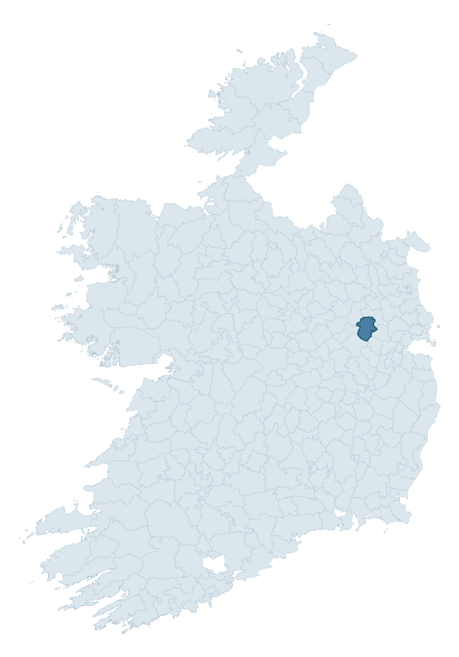
Where this barony sits in the Republic of Ireland
Geology and preservation
Bedrock geology shapes the landscape long before any settlement begins — controlling soil drainage, agricultural potential, the survival of upstanding monuments, and the preservation of buried archaeology. The figures below come from the Geological Survey Ireland 1:100,000 bedrock map.
The bedrock underlying Moyfenrath Lower is predominantly limestone (97% of the barony by area), laid down during the Carboniferous period (100% by area, around 359 to 299 million years ago). Limestone is the most heritage-rich bedrock in Ireland. It supports fertile, well-drained soils that favoured dense Early Medieval settlement and Norman manorial agriculture, and it weathers into karst features — sinkholes, caves, swallow holes, and souterrains — that frequently carry archaeology. Where peat overlies limestone, organic preservation can be exceptional. The single largest mapped unit is the Lucan Formation (67% of the barony's bedrock). With only 2 distinct rock types mapped, the barony is geologically uniform compared to the rest of the Republic (15th percentile for diversity) — a single coherent bedrock landscape.
Rock type composition
Largest mapped unit: Lucan Formation (67% of the barony)
Placename evidence
Logainm records 20 heritage-diagnostic placenames for Moyfenrath Lower, drawn from townland and civil-parish names across the barony. The dominant stratum is pre-Christian and Early Medieval defensive — ráth-, lios-, dún-, and caiseal-prefixed names that mark Iron Age and early historic settlement. The leading diagnostic roots are ráth- (11 — earthen ringfort), cill- (7 — church), and carn- (1 — cairn). This is below the ROI average of 30.7 heritage placenames per barony, suggesting either lighter survey coverage or a townland-naming tradition that draws more on generic landscape vocabulary. The presence of multiple heritage strata side by side indicates layered occupation of the landscape across successive prehistoric and historic periods. Logainm records 113 placenames for Moyfenrath Lower (predominantly townland names). Of these, 20 (18%) carry one of the diagnostic Gaelic roots tracked above; the remainder draw on more generic landscape vocabulary that does not encode a heritage period.
Pre-Christian / Early Medieval Defensive
| Root | Count | Meaning |
|---|---|---|
| ráth- | 11 | earthen ringfort |
Early Christian Ecclesiastical
| Root | Count | Meaning |
|---|---|---|
| cill- | 7 | church (early) |
Burial, Ritual, and Norse-Contact
| Root | Count | Meaning |
|---|---|---|
| carn- | 1 | cairn |
Other baronies in Meath

Explore further
Grounding History: 10 Maps of Northern Ireland’s Past
If you’re interested in Irish heritage more widely, the companion report for Northern Ireland brings together the analysis of all 462 NI wards into one place through 10 high-quality maps — covering monument density, archaeological periods, placename heritage, terrain, wetland, and the historic landscape at first survey. Take a look.
About this profile
Click any section below to expand.
What is a barony?
A barony is a historic administrative unit in Ireland, broadly equivalent to an English hundred. The 280 baronies used here are from the OSi 2019 National Statutory Boundaries (generalised 20m), covering the 26 counties of the Republic of Ireland. Baronies derive from the Norman period, were formalised in the 17th century, and have not been redrawn for statistical purposes. They vary enormously in area, from compact urban baronies in Dublin to vast upland baronies in Connacht, and should not be compared by raw site count without accounting for area differences.
What counts as a site?
This profile combines three distinct heritage registers, each with its own definition of what constitutes a recordable site:
- Archaeological sites (NMS). The National Monuments Service Sites and Monuments Record (SMR) catalogues every known archaeological monument or site of archaeological interest in the Republic, from prehistoric burial mounds and ringforts to medieval churches and post-medieval defensive works. Inclusion does not require legal protection — only that the site has been identified, surveyed, and assessed as having archaeological value. A separate subset of these sites lies within a recorded protection zone, which gives them statutory protection under the National Monuments Acts.
- Listed buildings (NIAH). The National Inventory of Architectural Heritage records buildings of architectural, historical, archaeological, artistic, cultural, scientific, social, or technical interest. Each surveyed structure is appraised on a five-tier scale: International, National, Regional, Local, and Record-Only. The NIAH appraisal is informational rather than strictly statutory, but it underpins local-authority Record of Protected Structures (RPS) listings.
- Heritage placenames (Logainm). Logainm is the authoritative database of Irish placenames maintained by the Placenames Branch. This profile applies a heritage-diagnostic classifier to the Irish-language form of each townland name, flagging roots that signal defensive sites (ráth-, lios-, dún-, caiseal-, cathair-), ecclesiastical foundations (cill-, teampall-, domhnach-, mainistir-), prehistoric burial-ritual features (tuaim-, carn-, leaba-), or Norse-contact settlement (gall-). Townlands without one of these diagnostic roots are not flagged here — they may still carry historical significance, but that significance is not encoded in the name itself.
Editorial principles
The narrative sections of this profile follow several explicit principles:
- Evidential. Every claim about this barony’s heritage character is anchored in the underlying register data. Where a site count, a placename count, or a percentile rank is cited, it is computed from the source datasets at export time, not estimated.
- Comparative. Counts and metrics are reported alongside their percentile rank against the other 279 ROI baronies. A barony with 50 ringforts in absolute terms could be unusually high or unusually low depending on its size and regional context; percentile ranking removes that ambiguity.
- Transparent on limits. Where a register has known coverage gaps, survey biases, or data-quality issues that affect this barony’s figures, the profile flags them rather than presenting the numbers as definitive.
- No interpretation beyond what the data supports. The narrative does not speculate about historical events, social dynamics, or cultural meaning beyond what the recorded heritage and placename evidence directly attests.
Data caveats and limits
- NMS Sites and Monuments Record is the product of survey campaigns conducted at different intensities across different counties and decades. Some baronies have been surveyed more thoroughly than others, and absolute counts should be read in that light. Sites destroyed by development before survey are typically not represented; sites in heavily forested or upland terrain are sometimes under-recorded.
- NIAH coverage is broadly complete for the Republic of Ireland but the survey was conducted on a rolling county-by-county basis, and the most recent appraisal date varies. Buildings demolished or substantially altered after their original survey may still appear in the register; conversely, recent buildings of merit may not yet have been appraised.
- Logainm classification applies a deliberately conservative pattern-matching approach to the Irish-language townland forms. The classifier prioritises true positives over recall: a townland may carry a heritage signal that the classifier doesn’t recognise, particularly where the diagnostic root has been heavily anglicised or where the townland name draws on a less common term. The 60,000+ townland records and ~9,800 classified placenames give a substantial signal at barony scale, but individual townland names should be checked against Logainm directly for definitive interpretation.
- Period attribution. The chronological distribution reflects only those NMS sites that carry a recognised period attribution in the source data. Sites listed as “Unknown” period are excluded from the dated subset.
- Boundary changes. Some baronies have undergone minor boundary adjustments since their 19th-century definition; the OSi 2019 generalised boundaries used here are the current statutory definition and may differ slightly from historical maps in border areas.
- Bedrock geology is mapped at 1:100,000 scale, which means local variation within a barony — small pockets of different rock type, mineral veins, alluvium overlying bedrock — is generalised. The dominant-system and rocktype figures are area-weighted, so a barony reading “70% Carboniferous limestone” may still contain small but archaeologically important pockets of older or younger rock. Around 3% of GSI polygons do not match the lexicon and contribute no rocktype or system attribution.
Data sources
- National Monuments Service — Sites and Monuments Record (SMR) https://data.gov.ie/dataset/national-monuments-service-archaeological-survey-of-ireland
- National Inventory of Architectural Heritage (NIAH) https://data.gov.ie/dataset/national-inventory-of-architectural-heritage-niah-national-dataset
- Logainm — Placenames Database of Ireland https://www.logainm.ie/
- Ordnance Survey Ireland — National Statutory Barony Boundaries 2019 https://data-osi.opendata.arcgis.com/
- EURODEM — European Digital Elevation Model https://www.mapsforeurope.org/datasets/euro-dem
- ESA WorldCover https://esa-worldcover.org/en
- Geological Survey Ireland — 1:100,000 Bedrock Geology https://www.gsi.ie/en-ie/data-and-maps/Pages/Bedrock.aspx
Explore more: Search any of the 280 ROI baronies, browse by historical province, or read the methodology and data sources for the full Republic of Ireland Heritage Tool.