
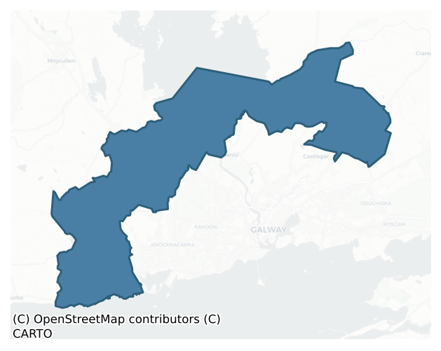
Galway is a barony of County Galway, in the historical province of Connacht (Irish: Gaillimh), covering 49.4 km² of land. The barony records 32 NMS archaeological sites and 316 NIAH listed buildings, placing it at around the 4th percentile among 280 ROI baronies for sites per km². This means it is in the bottom tenth of all baronies for sites per km². Dated archaeological evidence runs from the Early Bronze Age through to the Modern, spanning 6 of 9 archaeological periods, placing the barony in the 21st percentile among 280 ROI baronies for chronological depth. This means it is in the bottom third of all baronies for chronological depth. The largest dated subset of recorded sites dates to the Early Medieval.
Heritage at a glance
Percentile rankings throughout this profile compare each barony only against the other 279 Republic of Ireland baronies.
The recorded heritage of Galway
The National Monuments Service Sites and Monuments Record (SMR) is the statutory inventory of archaeological sites for the Republic of Ireland, maintained by the Department of Tourism, Culture, Arts, Gaeltacht, Sport and Media. Sites recorded here include earthworks, ringforts, megalithic tombs, ecclesiastical remains, and post-medieval features; not every record is legally protected, but each is registered as a monument of archaeological interest.
The National Monuments Service records 32 archaeological sites in Galway, putting it at the 4th percentile among 280 ROI baronies for sites per km². This means it is in the bottom tenth of all baronies for sites per km². A sparse recorded total of this kind in Ireland often reflects survey priority rather than genuine absence of past activity. Of these, 25 (78%) fall within a recorded monument protection zone. The record is dominated by ecclesiastical sites — churches, graveyards, and holy wells (11 sites, 34% of the total), with defensive sites forming a substantial secondary presence (8 sites, 25%). Church is the most prevalent type, making up 12% of the barony's recorded sites (4 records) — well above the ROI average of 4% across all baronies where this type occurs. Church is a building used for public Christian worship, of any date from c. 500 AD onwards. Other significant types include Ritual site – holy well (3) and Enclosure (2). Ritual site – holy well is a well or spring traditionally associated with a saint, often credited with healing properties; many trace earlier ritual origins but devotion is documented from the medieval period onwards; Enclosure is a banked or ditched feature of uncertain type, used as a catch-all where the original function cannot be determined from surface evidence.
Most common monument types
Hover or tap a monument type to see its definition.
| Type | Count |
|---|---|
| Church a building used for public Christian worship, of any date from c. 500 AD onwards | 4 |
| Ritual site – holy well a well or spring traditionally associated with a saint, often credited with healing properties; many trace earlier ritual origins but devotion is documented from the medieval period onwards | 3 |
| Enclosure a banked or ditched feature of uncertain type, used as a catch-all where the original function cannot be determined from surface evidence | 2 |
| Castle – tower house a fortified residential tower of four or five storeys, mostly built by lords in the 15th and 16th centuries and often within a defended bawn | 2 |
| Children's burial ground an unconsecrated medieval and early-modern burial ground for unbaptised or stillborn children, often called a cillín or ceallúnach | 2 |
| Graveyard a burial area associated with a church, in use from the medieval period onwards | 2 |
| Castle – unclassified a castle whose form cannot be precisely classified, dating somewhere between the late 12th and 16th centuries | 1 |
| House – 17th century a habitation building dated to the 17th century AD | 1 |
Chronological distribution
The dated archaeological record for Galway spans from the Early Bronze Age through to the Modern, with activity attested across 6 of 9 archaeological periods. This is the 21st percentile across ROI baronies — a relatively narrow chronological band, with much of Irish prehistory not represented in the dated record. The record is near-continuous, with only the Post Medieval period falling inside the span without any recorded sites. The Early Medieval contributes the largest single share (6 sites, 40%). A further 17 recorded sites (53% of the overall NMS register for the barony) carry no period attribution — appearing as 'Unknown' in the bar chart below. This typically reflects either records that pre-date the standardised period vocabulary or sites awaiting specialist dating review, rather than a genuine absence of chronological evidence.
Sample of recorded monuments
Show 25 sample monuments (of 32 total)
A representative sample of 25 recorded monuments drawn from the barony’s 32 total NMS entries. Sites within a recorded monument protection zone and rarer site types are prioritised so the list shows a meaningful cross-section rather than only the most common type. Each entry shows the official Sites and Monuments Record reference number and the description published by the National Monuments Service.
Castle – unclassified
At S edge of an extensive tract of bogland called the Curragh. In existence in 1574 when it was occupied by 'Donell Oge Ohologhan' (Nolan 1901, 115). Described in OS Letters as 'an old castle in ruins. The walls are…
At S edge of an extensive tract of bogland called the Curragh. In existence in 1574 when it was occupied by 'Donell Oge Ohologhan' (Nolan 1901, 115). Described in OS Letters as 'an old castle in ruins. The walls are still standing, thickness 4 feet [1.2m], height 54 feet [16.45m], bread[th] within walls 25 feet [7.6m]'. They also note 'that the extensive ruins of other edifices attached to it, are the remains of buildings got up after the erection of the castle by the family of the Burkes' (O'Flanagan 1927a, Vol. 1, 138). All that remains today are the ruins of a later house (GA082-018002-), the castle itself having fallen, and its stone reused, in the late 19th C. (Athy 1914, 154-5)
The above description is derived from the published 'Archaeological Inventory of County Galway Vol. I – West Galway'. Compiled by Paul Gosling (Dublin: Stationery Office, 1993).
Date of upload: 05 August 2010
House – 17th century
On the site of Carrowbrowne Castle (GA082-018001-). Fragmentary ruins of a two-storey rectangular house (L > 13.65m, Wth 6.52m int.), probably of 17-18th-C date. A large portion of SE side-wall, NE gable, and a portion…
On the site of Carrowbrowne Castle (GA082-018001-). Fragmentary ruins of a two-storey rectangular house (L > 13.65m, Wth 6.52m int.), probably of 17-18th-C date. A large portion of SE side-wall, NE gable, and a portion of NW wall survive. There is a doorway in SE wall flanked by three bays of ground and first-storey windows. There are fireplaces in NE corner on ground and first storeys, and possible traces of a W wing. A date-stone (1674), parts of an inscription, and a window head are visible in the adjoining farm buildings. (Athy 1914, 154-5)
The above description is derived from the published 'Archaeological Inventory of County Galway Vol. I – West Galway'. Compiled by Paul Gosling (Dublin: Stationery Office, 1993).
Date of upload: 05 August 2010
Burial ground
Close to S edge of an extensive tract of bogland known as the Curragh. Indicated on 1st ed. OS 6-inch map as an irregular enclosed area (c. 20m by c. 22m). The earliest graveslabs appear to date from the late 19th…
Close to S edge of an extensive tract of bogland known as the Curragh. Indicated on 1st ed. OS 6-inch map as an irregular enclosed area (c. 20m by c. 22m). The earliest graveslabs appear to date from the late 19th C.
The above description is derived from the published 'Archaeological Inventory of County Galway Vol. I – West Galway'. Compiled by Paul Gosling (Dublin: Stationery Office, 1993).
Date of upload: 05 August 2010
House – 18th/19th century
The Archaeological Survey of Ireland (ASI) is in the process of providing information on all monuments on The Historic Environment Viewer (HEV). Currently the information for this record has not been uploaded. To…
The Archaeological Survey of Ireland (ASI) is in the process of providing information on all monuments on The Historic Environment Viewer (HEV). Currently the information for this record has not been uploaded. To access available information for research purposes please make an appointment in advance with the Archive Unit (open Fridays 10.00 am – 5.00 pm), Department of Culture, Heritage and the Gaeltacht, The Custom House, Dublin 1 D01W6XO or email nmarchive@chg.gov.ie.
Chapel
The Archaeological Survey of Ireland (ASI) is in the process of providing information on all monuments on The Historic Environment Viewer (HEV). Currently the information for this record has not been uploaded. To…
The Archaeological Survey of Ireland (ASI) is in the process of providing information on all monuments on The Historic Environment Viewer (HEV). Currently the information for this record has not been uploaded. To access available information for research purposes please make an appointment in advance with the Archive Unit (open Fridays 10.00 am – 5.00 pm), Department of Culture, Heritage and the Gaeltacht, The Custom House, Dublin 1 D01W6XO or email nmarchive@chg.gov.ie.
Ringfort – unclassified
In a slight hollow in pasture-land. Indicated on 1st ed. of OS 6-inch map as a circular enclosure (D c. 30m). No visible surface trace survives.
The above description is derived from the published 'Archaeological…
In a slight hollow in pasture-land. Indicated on 1st ed. of OS 6-inch map as a circular enclosure (D c. 30m). No visible surface trace survives.
The above description is derived from the published 'Archaeological Inventory of County Galway Vol. I – West Galway'. Compiled by Paul Gosling (Dublin: Stationery Office, 1993).
Date of upload: 05 August 2010
Cenotaph
The following description is from the National Inventory of Architectural Heritage (see www.buildingsofireland.ie/buildings-search/building/30409301/father-griffin-monument-cloghscoltia-galway last accessed 4 August…
The following description is from the National Inventory of Architectural Heritage (see www.buildingsofireland.ie/buildings-search/building/30409301/father-griffin-monument-cloghscoltia-galway last accessed 4 August 2021):
Rectangular-plan tapered monument, erected c.1925, renovated 1992. Limestone block construction comprising central block with plaques having inscriptions and religious iconography, set on plinth having coping above and having flanking U-plan walling having inscribed plaques. Chamfered coping and tapered stops to front of flanking wall. Set on concrete platform with steps and cast-iron turnstile and railing.
This religious and republican monument was erected to commemorate Fr Michael Griffin, a local priest who 'would not break the seal of confession'. The simple yet functional form of the monument is enlivened by the large amount of text on the central and flanking plaques. Also, the detailed religious iconography increases the artistic appeal of the structure. This monument is of social and historical significance, its roadside location providing a feature of interest and a poignant reminder of Ireland's troubled past. Its style and design is similar to other nationalist monuments dispersed throughout the Irish countryside.
Compiled by: Olive Alcock
Date of upload: 4 August 2021
Crannog
The Archaeological Survey of Ireland (ASI) is in the process of providing information on all monuments on The Historic Environment Viewer (HEV). Currently the information for this record has not been uploaded. To…
The Archaeological Survey of Ireland (ASI) is in the process of providing information on all monuments on The Historic Environment Viewer (HEV). Currently the information for this record has not been uploaded. To access available information for research purposes please make an appointment in advance with the Archive Unit (open Fridays 10.00 am – 5.00 pm), Department of Culture, Heritage and the Gaeltacht, The Custom House, Dublin 1 D01W6XO or email nmarchive@chg.gov.ie.
Cairn – unclassified
On a low hillock sloping gently to the N with panoramic views over Lough Corrib, in rough rocky pastureland. When initially inspected in April 2002, this small partially tumbled rectangular drystone cairn (L 1.6m…
On a low hillock sloping gently to the N with panoramic views over Lough Corrib, in rough rocky pastureland. When initially inspected in April 2002, this small partially tumbled rectangular drystone cairn (L 1.6m ESE-WNW; Wth 0.8m; H 0.6m) was obscured by the growth of briars. It was known locally as a Fenian grave and it may be a memorial cairn of 18th-century date. On re-inspection in January 2023, the cairn was still extant but collapsed material was evident around all sides of it and the area itself was more densely overgrown with scrub.
Compiled by: Olive Alcock
Edited by: Olive Alcock
Date of revised upload: 1 February 2023
Inscribed stone
Built into a wall in the vicinity of the site of Carrowbrowne Castle (GA082-018001-) and an associated house (GA082-018002-). An inscribed stone bearing the date 1674 may be the datestone of the house.
Compiled by:…
Built into a wall in the vicinity of the site of Carrowbrowne Castle (GA082-018001-) and an associated house (GA082-018002-). An inscribed stone bearing the date 1674 may be the datestone of the house.
Compiled by: Olive Alcock
Date of upload: 16 February 2023
Structure
Located on top of an overgrown rocky knoll, sloping steeply to the W, in an area of undulating rough pasture and scrub. An unroofed narrow drystone subrectangular structure (5.3m NNW-SSE; 0.8-1.18m ENE-WSW; H 1-1.5m) is…
Located on top of an overgrown rocky knoll, sloping steeply to the W, in an area of undulating rough pasture and scrub. An unroofed narrow drystone subrectangular structure (5.3m NNW-SSE; 0.8-1.18m ENE-WSW; H 1-1.5m) is visible to the E of a grassy platform/terrace (c. 6m x c. 6m) on the knoll. It is open at its S end and is constructed of a mix of roughly coursed large stones and boulders of local pink granite. The N end consists of a large lower flag-like boulder (Wth 0.8m; H 1.08m T 0.6m) with a smaller boulder on top. The E side is defined by four boulders, three courses high, and the W side consists of five boulders, two courses high. Spalls and packing stones are visible and more recent field-clearance stones have been piled on top of the E side. The interior is littered with collapsed boulders. An outer wall line (L 6.67m), suggesting double-walling (total Wth 1.6m), is visible on the E side of the structure. Its mid-section has collapsed outwards and the N end extends further to the N of E side.
Walling (L 2.84m; max. H 1.3m), two to three courses high, extends to the W off the S end of the W side of the structure. It is initially straight, then kinks to the SW where it merges with outcropping rock (L 2.3m), aligned roughly NE-SW, resulting in a ‘court-like’ feature on this side of the structure. A large roughly square boulder (1.03m N-S; 1.03m E-W; max. T 0.54m) is visible on the ground c. 2.3m to the SW of the walling and an enormous irregular natural boulder (…
Architectural fragment
This architectural fragment came to light during recent cable-laying in the vicinity of Cloonacauneen Castle (GA082-029—-). It was moved to its present location for safe-keeping. The fragment consists of a curving…
This architectural fragment came to light during recent cable-laying in the vicinity of Cloonacauneen Castle (GA082-029—-). It was moved to its present location for safe-keeping. The fragment consists of a curving chamfered block of stone (max. L 0.82m; max. Wth 0.24m; T 0.24m). Its face is lightly hammer dressed. The base of the stone is squared-off but the top of it is very irregular due to damage. The inward edge is smooth. The shape and form of the stone suggest that it was part of the upper right-hand side of a doorway and that it is most likely from, or associated with, the castle.
Compiled by: Olive Alcock
Date of upload 3 May 2023
Enclosure
On N-facing slope in pastureland. Marked on 3rd ed. of OS 6-inch map (1947) as a enclosure (D c. 30m) cut by field walls at NE and SSW. No visible surface trace survives.
The above description is derived from the…
On N-facing slope in pastureland. Marked on 3rd ed. of OS 6-inch map (1947) as a enclosure (D c. 30m) cut by field walls at NE and SSW. No visible surface trace survives.
The above description is derived from the published 'Archaeological Inventory of County Galway Vol. I – West Galway'. Compiled by Paul Gosling (Dublin: Stationery Office, 1993).
Date of upload: 05 August 2010
Castle – tower house
On NE-facing slope overlooking an extensive tract of bogland known as the Curragh. In existence in 1574 when it was in the possession of 'Ricard beg' Burke (Nolan 1901, 115). Well-preserved rectangular tower (L 9.45m,…
On NE-facing slope overlooking an extensive tract of bogland known as the Curragh. In existence in 1574 when it was in the possession of 'Ricard beg' Burke (Nolan 1901, 115). Well-preserved rectangular tower (L 9.45m, Wth 7.6m) of four storeys. A gabled house was built against S wall in 19th C: it and the tower were renovated in 1960s and are still occupied as a private residence. The following description is based largely on Athy's survey (1914, 173-6): a pointed-arch doorway of two orders, set off-centre in E wall, gives access to a lobby, with murder-hole above, and there is a spiral stair in SE corner. The ground, 1st and 2nd floors each comprise a main chamber with a subsidiary one to E. A stone vault exists between 2nd/3rd floors and there are fireplaces in N wall on 1st and 3rd floors. An enclosed latrine gallery runs along E side of main chamber between 1st and 2nd floors: there is also a latrine on 3rd floor. Beneath the floor on S side of the 3rd floor is a concealed chamber in the thickness of the arch. All the windows were single or double lights with ogee or flat heads. Only the base of the parapets survived in 1914. (O'Flanagan 1927a, Vol. 1, 331)
The above description is derived from the published 'Archaeological Inventory of County Galway Vol. I – West Galway'. Compiled by Paul Gosling (Dublin: Stationery Office, 1993).
Date of upload: 05 August 2010
Children's burial ground
To E of a laneway c. 270m NNE of Killeen Castlfc (GA082-050—-). Described in OS Letters as 'a burying place now called Lisín' (O'Flanagan 1927a, Vol. 1, 320), it consists of a subrectangular area (L c. 30m, Wth c.…
To E of a laneway c. 270m NNE of Killeen Castlfc (GA082-050—-). Described in OS Letters as 'a burying place now called Lisín' (O'Flanagan 1927a, Vol. 1, 320), it consists of a subrectangular area (L c. 30m, Wth c. 28m) delimited by a stone wall. Most of the headstones mark late 19th-C adult burials, but the name suggests the presence of child burials also.
The above description is derived from the published 'Archaeological Inventory of County Galway Vol. I – West Galway'. Compiled by Paul Gosling (Dublin: Stationery Office, 1993).
Date of upload: 05 August 2010
Castle – tower house
On the side of a byroad in gently undulating farmland. In existence in 1574 when it was in the possession of 'Wm and Redmund mac Wm ffiegh' Burke (Nolan 1901, 115). A neat, almost square tower of four storeys. The…
On the side of a byroad in gently undulating farmland. In existence in 1574 when it was in the possession of 'Wm and Redmund mac Wm ffiegh' Burke (Nolan 1901, 115). A neat, almost square tower of four storeys. The original doorway (L 6.8m, Wth 6.2m), centrally placed in N wall, was later expanded into an arch, and a corresponding arch (now blocked) occurs in S wall. The doorway gave access directly into the ground-floor chamber with spiral stairs in NW corner. Stone vaults exist between ground/1st floor and 2nd/3rd floors. There is an intramural passage along W wall between 2nd/3rd floors: probably leading to a latrine. Only the base of the rooftop parapet survives. The windows are all single or double lights with ogival, round and flat heads. The traces of a later pitched roof on S wall are probably coeval with the arches. A ruined, 19th-C house abuts W wall (Athy 1914, 171-3; O'Flanagan 1927a, Vol. 1, 139). The rectangular foundations of a second house lie to N of the castle and there are also traces of a rectangular enclosure in the field to NE, possibly a remnant of the bawn.
The above description is derived from the published 'Archaeological Inventory of County Galway Vol. I – West Galway'. Compiled by Paul Gosling (Dublin: Stationery Office, 1993).
Date of upload: 05 August 2010
Graveyard
On W side of byroad to Bearna Quay: the townland boundary runs along centre of this road. Indicated on 1st ed. of OS 6-inch map as an enclosed rectangular graveyard (c. 45m by c. 30m). Subsequently extended to W. Not…
On W side of byroad to Bearna Quay: the townland boundary runs along centre of this road. Indicated on 1st ed. of OS 6-inch map as an enclosed rectangular graveyard (c. 45m by c. 30m). Subsequently extended to W. Not visited.
The above description is derived from the published 'Archaeological Inventory of County Galway Vol. I – West Galway'. Compiled by Paul Gosling (Dublin: Stationery Office, 1993).
Date of upload: 05 August 2010
Enclosure
In pastureland on a N-facing slope. Originally identified during aerial reconnaissance in 1989. This subrectangular enclosure (30m E-W; 18m N-S) is defined by the remains of low bank of earth and stone (Wth 2.2m; int. H…
In pastureland on a N-facing slope. Originally identified during aerial reconnaissance in 1989. This subrectangular enclosure (30m E-W; 18m N-S) is defined by the remains of low bank of earth and stone (Wth 2.2m; int. H 0.18m; ext. H 0.3m) to the W, N and E and by traces of a levelled bank (Wth 4.4m; int. H 0.18m; ext. H 0.15m) on the S side. Short portions of a linear bank of similar dimensions extend for a further length of c. 4m from the NE and SE corners. Another linear bank (long axis c. N-S; L 21m) of similar dimensions is visible c. 13m to the E. A large D-shaped depression encloses the area to S. Recent ground disturbance had occurred within and around monument. Cloonacauneen Castle (GA082-029—-) is c. 20m to the NW.
Compiled by: Olive Alcock
Date of upload: 10 November 2016
Graveyard
The Archaeological Survey of Ireland (ASI) is in the process of providing information on all monuments on The Historic Environment Viewer (HEV). Currently the information for this record has not been uploaded. To…
The Archaeological Survey of Ireland (ASI) is in the process of providing information on all monuments on The Historic Environment Viewer (HEV). Currently the information for this record has not been uploaded. To access available information for research purposes please make an appointment in advance with the Archive Unit (open Fridays 10.00 am – 5.00 pm), Department of Culture, Heritage and the Gaeltacht, The Custom House, Dublin 1 D01W6XO or email nmarchive@chg.gov.ie.
Children's burial ground
Associated with a church site (GA081-007001-). The graveyard consists of a rectangular area (L 25m, Wth 18.8m), bounded by modern field walls, within which numerous small set stones are visible, haphazardly…
Associated with a church site (GA081-007001-). The graveyard consists of a rectangular area (L 25m, Wth 18.8m), bounded by modern field walls, within which numerous small set stones are visible, haphazardly arranged.
The above description is derived from the published 'Archaeological Inventory of County Galway Vol. I – West Galway'. Compiled by Paul Gosling (Dublin: Stationery Office, 1993).
Date of upload: 05 August 2010
Ritual site – holy well
On roadside verge immediately E of Toberoran Stream. This well, correctly Tobar Uarán, consists of a natural spring, dry at time of visit, and now heavily overgrown.
The above description is derived from the…
On roadside verge immediately E of Toberoran Stream. This well, correctly Tobar Uarán, consists of a natural spring, dry at time of visit, and now heavily overgrown.
The above description is derived from the published 'Archaeological Inventory of County Galway Vol. I – West Galway'. Compiled by Paul Gosling (Dublin: Stationery Office, 1993).
Date of upload: 05 August 2010
Ritual site – holy well
On N-facing slope c. 100m NW of a road and td. boundary. All that remains of this well, correctly Tobar an Domhnaigh, is a patch of rough ground in SE part of a field. (O'Flanagan 1927a, Vol. 1, 325)
The above…
On N-facing slope c. 100m NW of a road and td. boundary. All that remains of this well, correctly Tobar an Domhnaigh, is a patch of rough ground in SE part of a field. (O'Flanagan 1927a, Vol. 1, 325)
The above description is derived from the published 'Archaeological Inventory of County Galway Vol. I – West Galway'. Compiled by Paul Gosling (Dublin: Stationery Office, 1993).
Date of upload: 05 August 2010
Ritual site – holy well
In a small wood close to N boundary of td. and c. 70m N of a byroad. This well, correctly Tobar Mac Duach, is completely overgrown but appears to consist of a natural spring enclosed by a small rectangular drystone…
In a small wood close to N boundary of td. and c. 70m N of a byroad. This well, correctly Tobar Mac Duach, is completely overgrown but appears to consist of a natural spring enclosed by a small rectangular drystone enclosure (L 2m, Wth 1.7m). No evidence of veneration noted. (O'Flanagan 1927a, Vol. 1, 326)
The above description is derived from the published 'Archaeological Inventory of County Galway Vol. I – West Galway'. Compiled by Paul Gosling (Dublin: Stationery Office, 1993).
Date of upload: 05 August 2010
Church
In rough pastureland sloping to the S, on the N side of the old Galway-Barna road and to the W of the roadway leading to the Silver Strand. Described in the OS Letters (O'Flanagan 1927a, Vol. 1, 345) as 'Barna old…
In rough pastureland sloping to the S, on the N side of the old Galway-Barna road and to the W of the roadway leading to the Silver Strand. Described in the OS Letters (O'Flanagan 1927a, Vol. 1, 345) as 'Barna old chapel' to distinguish it from the later R.C. Chapel, which stood c. 90m to its WSW, suggesting that it may be the site of a pre-emancipation R.C. church. On inspection in February 1989 the church (ext. dims. 15.5m E-W; 6m N-S; wall T 0.7m), which occupied the NW corner of a small field, was in a very ruinous condition. It was constructed of uncoursed mortared roughly cut blocks of granite. Both overgrown gables survived, that to the E was 3m high. The N wall survived to a maximum height of 1.5m and the S wall was partially destroyed but its lower courses were intact. No architectural features were evident. The interior of the church was completely overgrown and occupied by field-clearance debris. The remains of a small stone structure were visible near the SE corner. On re-inspection in October 2019 it was noted that the church was much more densely overgrown and the interior was inaccessible. A graveyard (GA093-003003-) is associated and a holy well (GA093-003001-) lies c. 40m to the E. (Gosling 1993, 103)
The following images have been uploaded:
GA093-003002-_01 Overgrown W gable.jpg
GA093-003002-_02 NW corner from W
GA093-003002-_03 Looking W from NW corner
Compiled by: Olive Alcock
Date of upload: 17 October 2019
Church
On N-facing slope in area of scrub and woodland. No visible trace survives; the site is marked simply as 'Graveyard' on 1st ed. of OS 6-inch map but this probably refers to the associated CBG (GA081-007002-). All that…
On N-facing slope in area of scrub and woodland. No visible trace survives; the site is marked simply as 'Graveyard' on 1st ed. of OS 6-inch map but this probably refers to the associated CBG (GA081-007002-). All that appears in 3rd ed. (1947) is a cross symbol alongside the site name. Possibly the site of a 19th-C R.C. chapel.
The above description is derived from the published 'Archaeological Inventory of County Galway Vol. I – West Galway'. Compiled by Paul Gosling (Dublin: Stationery Office, 1993).
Date of upload: 05 August 2010
Listed buildings
The National Inventory of Architectural Heritage (NIAH) is a state survey appraising buildings of architectural, historical, archaeological, artistic, cultural, scientific, social, or technical interest. Each surveyed structure receives a rating from International (the highest, for buildings of European importance) through National, Regional, Local, and Record-Only.
The NIAH records 316 listed buildings in Galway, the 89th percentile across ROI baronies for listed-building density. Among these, 9 are graded National — buildings of interest to the whole of Ireland rather than only its region. The Republic holds 937 National-graded buildings in total, so this barony accounts for around 1% of the national total. Construction dates concentrate most heavily in the Victorian (1830-1900) period. The most-recorded building type is house (155 examples, 49% of the listed stock).
Terrain and environment
Mean elevation across the barony is 30m — the 6th percentile among 280 ROI baronies for elevation. This means it is in the bottom tenth of all baronies for elevation. This is a relatively low-lying landscape by ROI standards. Elevation matters for heritage because higher-altitude baronies typically favour defensive monuments — ringforts and hilltop forts placed on prominent ground — while lowland baronies are more likely to carry the dense settlement and church networks of intensive agricultural landscapes. Mean slope is 2.3° — the 20th percentile among 280 ROI baronies for slope. This means it is in the bottom third of all baronies for slope. This is broadly flat terrain, the kind of landscape best suited to intensive agriculture. Slope is a key control on both land use and archaeological preservation: steep ground resists ploughing and tends to preserve earthworks intact, while gentle slopes favour intensive cultivation that damages or destroys surface archaeology over time. The Topographic Wetness Index averages 11.7, the 88th percentile among 280 ROI baronies for wetness. This means it is in the top fifth of all baronies for wetness. This is wet, slow-draining ground by ROI standards — the kind of landscape that may carry waterlogged archaeological sites of unusual preservation value. Drainage matters for heritage because poorly-drained ground preserves organic archaeology (wooden trackways, leather, textiles, and on rare occasions human remains) far better than free-draining soil; well-drained ground favours arable use but destroys organic material rapidly. The land-cover mosaic combines improved grassland (64%), woodland (15%), and open water (15%), giving a mixed agricultural and semi-natural landscape. In overall character, this is low-lying, gently-sloping terrain — characteristic of Ireland's central plain and coastal lowlands, with land use dominated by improved grassland.
Terrain measurements
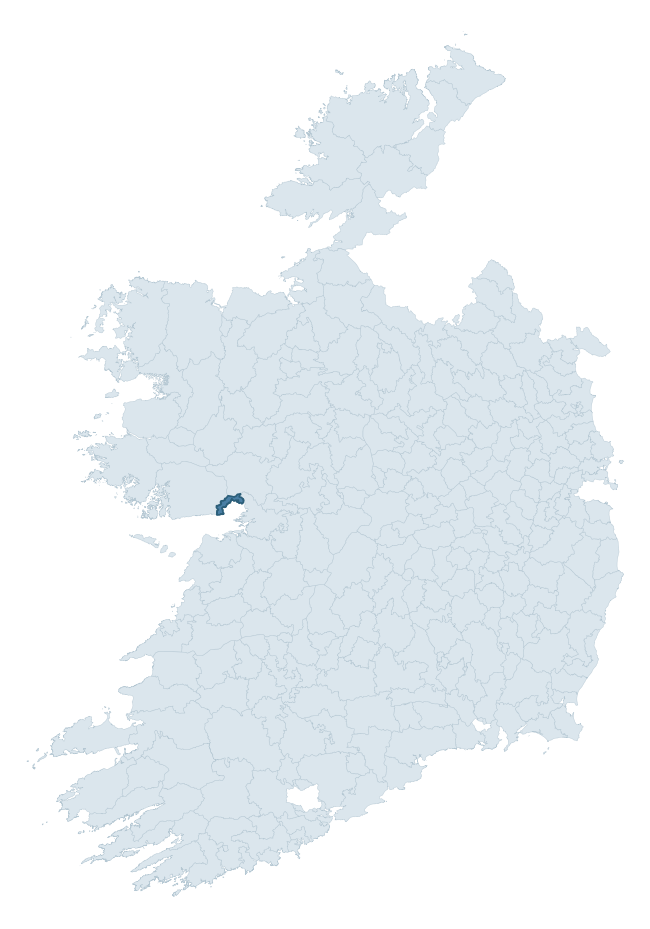
Where this barony sits in the Republic of Ireland
Geology and preservation
Bedrock geology shapes the landscape long before any settlement begins — controlling soil drainage, agricultural potential, the survival of upstanding monuments, and the preservation of buried archaeology. The figures below come from the Geological Survey Ireland 1:100,000 bedrock map.
The bedrock underlying Galway is predominantly limestone (56% of the barony by area), laid down during the Carboniferous period (56% by area, around 359 to 299 million years ago). Limestone is the most heritage-rich bedrock in Ireland. It supports fertile, well-drained soils that favoured dense Early Medieval settlement and Norman manorial agriculture, and it weathers into karst features — sinkholes, caves, swallow holes, and souterrains — that frequently carry archaeology. Where peat overlies limestone, organic preservation can be exceptional. A substantial secondary geology of monzogranite, mafic, megacrystic (24%) and megacrystic pink/grey monzogranite (17%) adds further variety to the underlying landscape. The single largest mapped unit is the Burren Formation (56% of the barony's bedrock).
Rock type composition
Largest mapped unit: Burren Formation (56% of the barony)
Placename evidence
Logainm records 7 heritage-diagnostic placenames for Galway, a modest sample drawn predominantly from the townland record. The dominant stratum is early christian ecclesiastical. The most frequent diagnostic roots are cill- (2) and cillín- (2). With a sample of this size the count should be treated as indicative rather than definitive.
Pre-Christian / Early Medieval Defensive
| Root | Count | Meaning |
|---|---|---|
| ráth- | 1 | earthen ringfort |
Early Christian Ecclesiastical
| Root | Count | Meaning |
|---|---|---|
| cill- | 2 | church (early) |
| cillín- | 2 | unconsecrated burial ground |
Other baronies in Galway
About this profile
Click any section below to expand.
What is a barony?
A barony is a historic administrative unit in Ireland, broadly equivalent to an English hundred. The 280 baronies used here are from the OSi 2019 National Statutory Boundaries (generalised 20m), covering the 26 counties of the Republic of Ireland. Baronies derive from the Norman period, were formalised in the 17th century, and have not been redrawn for statistical purposes. They vary enormously in area, from compact urban baronies in Dublin to vast upland baronies in Connacht, and should not be compared by raw site count without accounting for area differences.
What counts as a site?
This profile combines three distinct heritage registers, each with its own definition of what constitutes a recordable site:
- Archaeological sites (NMS). The National Monuments Service Sites and Monuments Record (SMR) catalogues every known archaeological monument or site of archaeological interest in the Republic, from prehistoric burial mounds and ringforts to medieval churches and post-medieval defensive works. Inclusion does not require legal protection — only that the site has been identified, surveyed, and assessed as having archaeological value. A separate subset of these sites lies within a recorded protection zone, which gives them statutory protection under the National Monuments Acts.
- Listed buildings (NIAH). The National Inventory of Architectural Heritage records buildings of architectural, historical, archaeological, artistic, cultural, scientific, social, or technical interest. Each surveyed structure is appraised on a five-tier scale: International, National, Regional, Local, and Record-Only. The NIAH appraisal is informational rather than strictly statutory, but it underpins local-authority Record of Protected Structures (RPS) listings.
- Heritage placenames (Logainm). Logainm is the authoritative database of Irish placenames maintained by the Placenames Branch. This profile applies a heritage-diagnostic classifier to the Irish-language form of each townland name, flagging roots that signal defensive sites (ráth-, lios-, dún-, caiseal-, cathair-), ecclesiastical foundations (cill-, teampall-, domhnach-, mainistir-), prehistoric burial-ritual features (tuaim-, carn-, leaba-), or Norse-contact settlement (gall-). Townlands without one of these diagnostic roots are not flagged here — they may still carry historical significance, but that significance is not encoded in the name itself.
Editorial principles
The narrative sections of this profile follow several explicit principles:
- Evidential. Every claim about this barony’s heritage character is anchored in the underlying register data. Where a site count, a placename count, or a percentile rank is cited, it is computed from the source datasets at export time, not estimated.
- Comparative. Counts and metrics are reported alongside their percentile rank against the other 279 ROI baronies. A barony with 50 ringforts in absolute terms could be unusually high or unusually low depending on its size and regional context; percentile ranking removes that ambiguity.
- Transparent on limits. Where a register has known coverage gaps, survey biases, or data-quality issues that affect this barony’s figures, the profile flags them rather than presenting the numbers as definitive.
- No interpretation beyond what the data supports. The narrative does not speculate about historical events, social dynamics, or cultural meaning beyond what the recorded heritage and placename evidence directly attests.
Data caveats and limits
- NMS Sites and Monuments Record is the product of survey campaigns conducted at different intensities across different counties and decades. Some baronies have been surveyed more thoroughly than others, and absolute counts should be read in that light. Sites destroyed by development before survey are typically not represented; sites in heavily forested or upland terrain are sometimes under-recorded.
- NIAH coverage is broadly complete for the Republic of Ireland but the survey was conducted on a rolling county-by-county basis, and the most recent appraisal date varies. Buildings demolished or substantially altered after their original survey may still appear in the register; conversely, recent buildings of merit may not yet have been appraised.
- Logainm classification applies a deliberately conservative pattern-matching approach to the Irish-language townland forms. The classifier prioritises true positives over recall: a townland may carry a heritage signal that the classifier doesn’t recognise, particularly where the diagnostic root has been heavily anglicised or where the townland name draws on a less common term. The 60,000+ townland records and ~9,800 classified placenames give a substantial signal at barony scale, but individual townland names should be checked against Logainm directly for definitive interpretation.
- Period attribution. The chronological distribution reflects only those NMS sites that carry a recognised period attribution in the source data. Sites listed as “Unknown” period are excluded from the dated subset.
- Boundary changes. Some baronies have undergone minor boundary adjustments since their 19th-century definition; the OSi 2019 generalised boundaries used here are the current statutory definition and may differ slightly from historical maps in border areas.
- Bedrock geology is mapped at 1:100,000 scale, which means local variation within a barony — small pockets of different rock type, mineral veins, alluvium overlying bedrock — is generalised. The dominant-system and rocktype figures are area-weighted, so a barony reading “70% Carboniferous limestone” may still contain small but archaeologically important pockets of older or younger rock. Around 3% of GSI polygons do not match the lexicon and contribute no rocktype or system attribution.
Data sources
- National Monuments Service — Sites and Monuments Record (SMR) https://data.gov.ie/dataset/national-monuments-service-archaeological-survey-of-ireland
- National Inventory of Architectural Heritage (NIAH) https://data.gov.ie/dataset/national-inventory-of-architectural-heritage-niah-national-dataset
- Logainm — Placenames Database of Ireland https://www.logainm.ie/
- Ordnance Survey Ireland — National Statutory Barony Boundaries 2019 https://data-osi.opendata.arcgis.com/
- EURODEM — European Digital Elevation Model https://www.mapsforeurope.org/datasets/euro-dem
- ESA WorldCover https://esa-worldcover.org/en
- Geological Survey Ireland — 1:100,000 Bedrock Geology https://www.gsi.ie/en-ie/data-and-maps/Pages/Bedrock.aspx
Explore more: Search any of the 280 ROI baronies, browse by historical province, or read the methodology and data sources for the full Republic of Ireland Heritage Tool.