
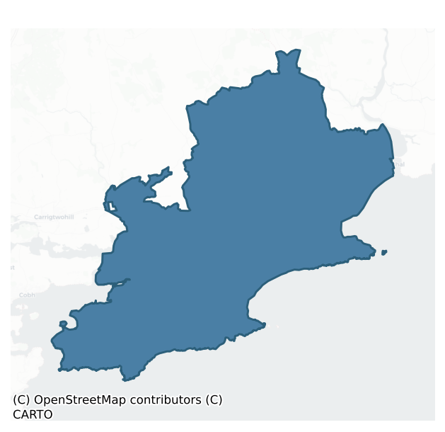
Imokilly is a barony of County Cork, in the historical province of Munster (Irish: Uí Mhic Coille), covering 384 km² of land. The barony records 725 NMS archaeological sites and 711 NIAH listed buildings, placing it at around the 50th percentile among 280 ROI baronies for sites per km². This means it is in the upper half of all baronies for sites per km². Dated archaeological evidence runs from the Mesolithic through to the Modern, spanning 9 of 9 archaeological periods, placing the barony in the 99th percentile among 280 ROI baronies for chronological depth. This means it is in the top tenth of all baronies for chronological depth. The largest dated subset of recorded sites dates to the Iron Age. Logainm flags 68 placenames in the barony as carrying a recognised heritage root; the largest share — around 56% — are names associated with early Christian church and monastic foundations.
Heritage at a glance
Percentile rankings throughout this profile compare each barony only against the other 279 Republic of Ireland baronies.
The recorded heritage of Imokilly
The National Monuments Service Sites and Monuments Record (SMR) is the statutory inventory of archaeological sites for the Republic of Ireland, maintained by the Department of Tourism, Culture, Arts, Gaeltacht, Sport and Media. Sites recorded here include earthworks, ringforts, megalithic tombs, ecclesiastical remains, and post-medieval features; not every record is legally protected, but each is registered as a monument of archaeological interest.
The National Monuments Service records 725 archaeological sites in Imokilly, putting it at the 50th percentile among 280 ROI baronies for sites per km². This means it is in the upper half of all baronies for sites per km². Protection coverage is near-universal — 668 sites (92%) fall within a recorded monument protection zone, indicating an extensively surveyed landscape. The record is dominated by defensive sites — ringforts, enclosures, hillforts, and stone forts (233 sites, 32% of the total), with agricultural and prehistoric industrial sites forming a substantial secondary presence (97 sites, 13%). Ringfort – rath is the most prevalent type, making up 15% of the barony's recorded sites (108 records), broadly in line with the ROI average of 20% across all baronies where this type occurs. Ringfort – rath is an earthen ringfort enclosed by a bank and external ditch — the most common Early Medieval farmstead, broadly dated 500–1000 AD. Other significant types include Fulacht fia (84) and Enclosure (73). Fulacht fia is a horseshoe-shaped Bronze Age burnt mound built around a sunken trough beside a water source, traditionally interpreted as a cooking site; Enclosure is a banked or ditched feature of uncertain type, used as a catch-all where the original function cannot be determined from surface evidence. Across the barony's 384 km², this gives a recorded density of 1.89 sites per km².
Most common monument types
Hover or tap a monument type to see its definition.
| Type | Count |
|---|---|
| Ringfort – rath an earthen ringfort enclosed by a bank and external ditch — the most common Early Medieval farmstead, broadly dated 500–1000 AD | 108 |
| Fulacht fia a horseshoe-shaped Bronze Age burnt mound built around a sunken trough beside a water source, traditionally interpreted as a cooking site | 84 |
| Enclosure a banked or ditched feature of uncertain type, used as a catch-all where the original function cannot be determined from surface evidence | 73 |
| Church a building used for public Christian worship, of any date from c. 500 AD onwards | 34 |
| Graveyard a burial area associated with a church, in use from the medieval period onwards | 29 |
Chronological distribution
The dated archaeological record for Imokilly spans from the Mesolithic through to the Modern, with activity attested across 9 of 9 archaeological periods. This places Imokilly in the top 1% of ROI baronies for chronological depth — few baronies record evidence across as many distinct archaeological periods. Every period from earliest to latest is represented in the record — an unbroken sequence of dated activity across the full chronological span. Activity concentrates most heavily in the Iron Age (153 sites, 32% of dated material), with the Early Medieval forming a secondary peak (134 sites, 28%). A further 240 recorded sites (33% of the overall NMS register for the barony) carry no period attribution — appearing as 'Unknown' in the bar chart below. This typically reflects either records that pre-date the standardised period vocabulary or sites awaiting specialist dating review, rather than a genuine absence of chronological evidence.
Sample of recorded monuments
Show 25 sample monuments (of 725 total)
A representative sample of 25 recorded monuments drawn from the barony’s 725 total NMS entries. Sites within a recorded monument protection zone and rarer site types are prioritised so the list shows a meaningful cross-section rather than only the most common type. Each entry shows the official Sites and Monuments Record reference number and the description published by the National Monuments Service.
Hilltop enclosure
In commanding position, on highest point of E-W ridge and enclosing hilltop. Subcircular area (72.4m N-S; 86.5m E-W) enclosed by earth and stone bank (H 2.8m); entrance (Wth c. 2m), to ENE, partially blocked by large…
In commanding position, on highest point of E-W ridge and enclosing hilltop. Subcircular area (72.4m N-S; 86.5m E-W) enclosed by earth and stone bank (H 2.8m); entrance (Wth c. 2m), to ENE, partially blocked by large sandstone block and revetted on N side by second block. Interior rises towards hill summit in centre; at WSW side of interior earthen arc of bank (H 1.1m) cuts off oval ara (24.3m NW-SE; 21.6m NE-SW). Souterrain(CO066-01002-) in centre. (O'Kelly 1945, 18-20)
The above description is derived from the published 'Archaeological Inventory of County Cork. Volume 2: East and South Cork' (Dublin: Stationery Office, 1994). In certain instances the entries have been revised and updated in the light of recent research.
Date of upload/revision: 14 January 2009
Sheela-na-gig
Taken from Aghadoe Castle (CO066-03801-) during its demolition and now in possession of owners of Aghadoe House (CO066-03803-). Rectangular limestoneslab (0.7m x 0.5m) with figure (H 0.4m; Wth 0.3m) picked out in raised…
Taken from Aghadoe Castle (CO066-03801-) during its demolition and now in possession of owners of Aghadoe House (CO066-03803-). Rectangular limestoneslab (0.7m x 0.5m) with figure (H 0.4m; Wth 0.3m) picked out in raised relief (0.1m) on one side. Female figure displays a large head, triangularin shape with eyes, nose, mouth and ears clearly defined. Torso shows form of rib-cage surmounted with small pendular breasts; legs are splayed, exhibiting genital area. Right foot and part of left foot broken off. Left hand raised, holding something broken aloft; right arm hangs by side of figure; fingers visible on hand. No. 7 in Cherry (1992, 4) catalogue.
The above description is derived from the published 'Archaeological Inventory of County Cork. Volume 2: East and South Cork' (Dublin: Stationery Office, 1994). In certain instances the entries have been revised and updated in the light of recent research.
Date of upload/revision: 14 January 2009
Image provided by and copyright of Amanda Clarke 2016-2022 https://holywellscorkandkerry.com/
Dovecote
To SW of Aghadoe House (CO066-03803-) and on or near site of castle (CO066-03801-). Roofless circular structure (int. diam. c. 3.5m; H c. 5m); door ope facing E. Internal wall lined with nesting boxes. Sheela-na-gig…
To SW of Aghadoe House (CO066-03803-) and on or near site of castle (CO066-03801-). Roofless circular structure (int. diam. c. 3.5m; H c. 5m); door ope facing E. Internal wall lined with nesting boxes. Sheela-na-gig (CO066-038002-) formerly incorporated into wall.
The above description is derived from the published 'Archaeological Inventory of County Cork. Volume 2: East and South Cork' (Dublin: Stationery Office, 1994). In certain instances the entries have been revised and updated in the light of recent research.
Date of upload/revision: 14 January 2009
Image provided by and copyright of Amanda and Peter Clarke 2016-2022 https://holywellscorkandkerry.com/
Ecclesiastical site
In a graveyard (CO066-041001-) at the W end of Killeagh village. The 1934 OS 6-inch map indicates 'St. Abban's Nunnery (site of)'. Smith (1750 vol. 1, 124) states 'at this place, was an ancient nunnery of canonesses,…
In a graveyard (CO066-041001-) at the W end of Killeagh village. The 1934 OS 6-inch map indicates 'St. Abban's Nunnery (site of)'. Smith (1750 vol. 1, 124) states 'at this place, was an ancient nunnery of canonesses, founded by St. Abban, in the sixth century' (see also Gwynn & Hadcock 1988, 391); Henchion (1972, 76) points out that 'another body of opinion …. claims in contradiction that the first church … was raised by Id or Liber, a disciple of St. Finbarr'; no visible surface trace of ancient remains.
The above description is derived from the published 'Archaeological Inventory of County Cork. Volume 2: East and South Cork' (Dublin: Stationery Office, 1994). In certain instances the entries have been revised and updated in the light of recent research.
Date of upload/revision: 14 January 2009
Barracks
Indicated on 1842 OS 6-inch map as Police Barracks at E end of Killeagh. Front (E) 3-storey, 5-bay; central rectangular doorway obscured by porch; stringcourse between ground and 1st floors. Gabled roof with end…
Indicated on 1842 OS 6-inch map as Police Barracks at E end of Killeagh. Front (E) 3-storey, 5-bay; central rectangular doorway obscured by porch; stringcourse between ground and 1st floors. Gabled roof with end chimneys. Additions to rear. Date plaque on front wall '17..'. According to local information barracks was partially destroyed by fire in early 1920s.
The above description is derived from the published 'Archaeological Inventory of County Cork. Volume 2: East and South Cork' (Dublin: Stationery Office, 1994). In certain instances the entries have been revised and updated in the light of recent research.
Date of upload/revision: 14 January 2009
Hillfort
In commanding position enclosing hilltop and ringfort (CO067-00102-). Circular area (diam. c. 150m) defined by earthen bank (int. H 0.5m; ext. H 1.8m) SSE->NNE; enclosure removed by pre-1842 reclamation to E. To W and…
In commanding position enclosing hilltop and ringfort (CO067-00102-). Circular area (diam. c. 150m) defined by earthen bank (int. H 0.5m; ext. H 1.8m) SSE->NNE; enclosure removed by pre-1842 reclamation to E. To W and NW, bank overgrown, defined by low earthen bank (max. int. H 0.4m) atop break in slope (max. ext. H 1m); in places only by break in slope, scatter of stones or, to W, piling up of large boulders. Clearly visible in aerial photograph (CASAP) as break in vegetation. Recent field fence continues line to S and N; may be slightly inside line of original bank; to N, field fence may overlie collapsed remains bank. Interior overgrown and rising towards hilltop. Rectangular depressions inside bank to N (1.2m x 0.8m; D 0.4m). Arc of possible second bank c. 50m outside S->N; defined by field fences. Four radial fields connect outer and inner banks; short length of fifth radial line visible to SE (CASAP), defined by change in vegetation; not located on ground. Three black patches visible in field to N between inner and outer enclosures (CASAP); visible on ground as patches of nettles.
The above description is derived from the published 'Archaeological Inventory of County Cork. Volume 2: East and South Cork' (Dublin: Stationery Office, 1994). In certain instances the entries have been revised and updated in the light of recent research.
Date of upload/revision: 14 January 2009
Brickworks
To S of Tourig river, just W of area named 'Old Brick Field' on 1842 OS 6-inch map, to S of 'Ordnance Ground'. Small section of late 19th/early 20th century brickworks survives; on site of earlier structures.…
To S of Tourig river, just W of area named 'Old Brick Field' on 1842 OS 6-inch map, to S of 'Ordnance Ground'. Small section of late 19th/early 20th century brickworks survives; on site of earlier structures. Rectangular Hoffman Continuous kiln remains, erected 1895 (Breslin 1991, 138). Brick-built (33.4m N-S; 18.3m E-W), consisting of 12 kiln chambers arranged in 2 parallel rows with thick dividing wall between them. Now used as cattle shelter. Tall chimney (base: 3.6m x 3.6m) free standing at S end. Other remains include floors of drying sheds, concrete base of steam engine, foundation of Mill house and office buildings. A more technologically advanced continuous kiln was built in 1912 – 'Buhrer Mechanical Draught Kiln' – but was dismantled in 1930s (Breslin 1991, 110). Area of 'Old Brick Field' contains numerous grass-covered humps; bricks everywhere.
The above description is derived from the published 'Archaeological Inventory of County Cork. Volume 2: East and South Cork' (Dublin: Stationery Office, 1994). In certain instances the entries have been revised and updated in the light of recent research.
Date of upload/revision: 14 January 2009
Religious house – Franciscan nuns (Poor Clares)
Convent of St. Anne, founded c. 1190 (Hayman 1855, 327); the nuns tended the beacon tower (Gwynn and Hadcock 1988, 325). Convent no longer standing by 1644; circular tower survived (H c. 24ft; diam. c. 10ft) until 1848…
Convent of St. Anne, founded c. 1190 (Hayman 1855, 327); the nuns tended the beacon tower (Gwynn and Hadcock 1988, 325). Convent no longer standing by 1644; circular tower survived (H c. 24ft; diam. c. 10ft) until 1848 when it was demolished to build present lighthouse (Hayman ibid., 328-9).
The above description is derived from the published 'Archaeological Inventory of County Cork. Volume 2: East and South Cork' (Dublin: Stationery Office, 1994). In certain instances the entries have been revised and updated in the light of recent research.
Date of upload/revision: 14 January 2009
Religious house – Franciscan friars
At S end of Youghal, just outside the medieval town walls, site of Franciscan friary founded in 1224 by Maurice Fitzgerald (Hayman 1855, 329; Gwynn and Hadcock 1988, 261). There is 'no trace of this Friary now…
At S end of Youghal, just outside the medieval town walls, site of Franciscan friary founded in 1224 by Maurice Fitzgerald (Hayman 1855, 329; Gwynn and Hadcock 1988, 261). There is 'no trace of this Friary now remaining' (Hayman ibid., 332); a drawing of 1585 (ibid., 331) shows standing remains but by 1681 there were 'only some small remains'. Hayman (ibid., 331-2) records many instances when human remains, building foundations and 'tomb-flags with fleureed crosses' were found in general area of site during foundation digging in early 19th century. O'Sullivan (1945, 96) locates the friary 'as extending from opposite the kitchen of the Devonshire Arms hotel to the end of the modern convent schools'. Two water fonts (CO067-028002-, CO067-028003-) from site in grounds of nearby Strand House; two pairs of ogee-heads (CO067-028004-, CO067-028005-) from window surrounds and two pointed door arches (CO067-028006-, CO067-028007-) set in garden wall of another nearby house.
The above description is derived from the published 'Archaeological Inventory of County Cork. Volume 2: East and South Cork' (Dublin: Stationery Office, 1994). In certain instances the entries have been revised and updated in the light of recent research.
Date of upload/revision: 14 January 2009
Town defences
Earliest record of town walls is murage grant of 1275 (O'Brien 1986, 372) which was renewed throughout late medieval period, but by 1631 walls were 'weak and ruinous' with 'no place to mount ordnance to defend the…
Earliest record of town walls is murage grant of 1275 (O'Brien 1986, 372) which was renewed throughout late medieval period, but by 1631 walls were 'weak and ruinous' with 'no place to mount ordnance to defend the harbour' (Coleman 1906, 103); re-fortified in 1641-2 (Harbison 1977, 62). Pacata Hibernia map (Wain 1965, 36-7) shows walled town in two sections with 'basetown' (Irishtown) to S; thirteen towers are shown including South Gate, North Gate and Water Gate, with outworks outside North Gate; E line of wall ran along waterfront; walled harbour with two entrance towers outside WaterGate. To-day N and W ruins of town wall including three towers survive and have been described as 'possibly the best preserved medieval town walls in Ireland' (Harbison, ibid.; see plan Cockburn 1976, 14-5; see photos Buckley 1900, 158-8). Two semicircular and one circular tower (Banshee; Montmorenci and Half-Moon) stand at S end of W wall; this section (surviving for c. 450m) overlooks area of medieval town. W wall rebuilt in upper courses; square placements for wooden supports for wall walk; upper part of parapet rebuilt (Thomas 1992, 215). Line of N wall (c. 275m) descends steeply to E, with no towers surviving. Riverside wall apparently slighter (H c. 5m; Wth c. 0.6m) so could be late medieval (ibid). Stone arch (CO067-029012-), known as 'Watergate' or 'Cromwell's Arch' (Condon 1945, opp. 120) 'is seemingly a modern restoration of the antique "water gate" ' (Buckley ibid,160), leading fr…
House – 16th century
Adjacent to St Mary's Church (CO067-02903-) 'a much-altered Elizabethan house' (Killanin and Duignan 1962, 460-1) built originally a College for choristers and serving a dual role as residence for the Warden of the…
Adjacent to St Mary's Church (CO067-02903-) 'a much-altered Elizabethan house' (Killanin and Duignan 1962, 460-1) built originally a College for choristers and serving a dual role as residence for the Warden of the Collegiate church of Youghal, established in 1464 by Richard Benet under a charter granted by Thomas Fitzgerald, 8th Earl of Desmond. After the Desmond Rebellion in 1586 some of the then Earl's extensive lands in Youghal and Lismore were granted to Sir Walter Raleigh who used both Lismore and Myrtle Grove as a base serving as mayor of Youghal from 1588 to 1599. 'Myrtle Grove' represents one of the earliest, unfortified, continuously occupied houses in Ireland.
A rectangular two-storey masonry house with an inhabited attic storey and some ad-hoc extensions at the N. There are three transverse gables on front and back elevations which together with the prominent chimneys provide an Elizabethan silhouette. However 'the windows have been modernized' (Hayman 1896, xiv-xv); the building has a relatively recent external appearance having been 'put into thorough repair' in 1897 (The Irish Builder, 1st Aug 1897). It represents one of the earliest, unfortified, continuously occupied houses in Ireland.
Some internal rooms are lined with floor to ceiling regular oak panels, topped with a frieze panel with dentils. In 'Raleigh's drawing room, the richly carved oak mantlepiece cornice 'rests upon three figures, representing Faith, Hope and Charity, between which…
College
Adjacent to St. Mary's church (CO067-02903-). Founded in 1464 by Earl of Desmond as 'Our Lady's College of Youghal' (Hayman 1896, xiii-xiv), consisting of 'a warden, eight ordained Fellows and eight lay brothers….in…
Adjacent to St. Mary's church (CO067-02903-). Founded in 1464 by Earl of Desmond as 'Our Lady's College of Youghal' (Hayman 1896, xiii-xiv), consisting of 'a warden, eight ordained Fellows and eight lay brothers….in addition to teaching, the Fellows served St. Mary's Churchand seven other churches in the Barony of Imokilly' (Wain 1965, 51). During Desmond rebellion, 'spoiled and well nigh demolished' (Hayman 1856, 16). Subsequently came into possesion of Richard Boyle, Earl of Cork, who rebuilt college c. 1605 as his private residence (ibid., 19). In 1641-2 Boyle 'added two large flanking towers to the house, built five circular turrets aroung the park, and cast up a platform of earth, on which he placed ordnance to command the town and harbour' (Hayman 1896, ibid.); he died there in 1643. By middle of 18th century house fallen into ruins; about 1782 was 'in a great measure rebuilt' (ibid.) so that 'of the old College building hardly a vestage remains' (ibid.). In 1860 'north Gothic wing' added (Wain 1966, 52). To-day 'the only relic of Boyle's house is an elaborate chimney-piece' (Killanin and Duignan 1962, 460) though two of towers survive, one incorporated into more recent buildings; house still a private residence.
See Excavations 1995, 9.
The above description is derived from the published 'Archaeological Inventory of County Cork. Volume 2: East and South Cork' (Dublin: Stationery Office, 1994). In certain instances the entries have been revised and updated in…
Almshouse
Fronting onto the north-west side of North Main Street at the junction of Church Street in the north sector of the medieval town of Youghal. Oldest surviving almshouses in Ireland (Craig 1982, 203), described as 'most…
Fronting onto the north-west side of North Main Street at the junction of Church Street in the north sector of the medieval town of Youghal. Oldest surviving almshouses in Ireland (Craig 1982, 203), described as 'most convincingly Jacobean' (ibid.). They were endowed by Richard Boyle, Earl of Cork, in either 1613 or 1634 (ibid.; Condon 1945,opp. 120) to house 'six poor widows (Protestants)' (Condon ibid.).
They consist of a four-bay, three-storey gabled-ended building, built of sandstone rubble. The rectangular windows formerly had stone mullion and transom divisions with occasional relieving arches visible in views where the render was removed. Four doorways with pointed arches are set in pairs on the ground floor, with window arrangements at first and second floor following the same alignment with that at ground floor varying to reflect the paired arrangement of doorways. The upper floor windows sit just under the eaves. A plaque, bearing the coat of arms of the founder is centrally placed on the front elevation (CO067-029017-). The NW gable 'turns the corner of two streets' into Church Street (Craig 1982, 203), and is broken by two small windows in the attic storey. The section on Church Street has a lower roof line, and is comprised of two, two-storey gable-fronted sections. Original stone hood-mouldings survive above ground floor level windows. Lewis (1837, vol. 2, 729) describes the building as 'recently rebuilt in their original style, with the arms of the foun…
Religious house – Benedictine monks
On SW side of Main Street. A 'much-altered gable' (Killanin and Duignan 1962, 459), identified by Hayman (1856, 14-5) as remains of Benedictine priory of St. John, in existence by 1306 (Gwynn and Hadcock 1988, 108).…
On SW side of Main Street. A 'much-altered gable' (Killanin and Duignan 1962, 459), identified by Hayman (1856, 14-5) as remains of Benedictine priory of St. John, in existence by 1306 (Gwynn and Hadcock 1988, 108). O'Sullivan (1945, 104-5) describes features in gable as 'pointed and delicately moulded sandstone doorway framed by a square-headed moulding', while directly above door is 'a single-light ogee window' (ibid.); also 'half-way along a narrow passage….are a piscina and a square aumbry' (ibid.); there may be further features to rear of building (see Hayman ibid).
The above description is derived from the published 'Archaeological Inventory of County Cork. Volume 2: East and South Cork' (Dublin: Stationery Office, 1994). In certain instances the entries have been revised and updated in the light of recent research.
Date of upload/revision: 14 January 2009
Mansion house
The Archaeological Survey of Ireland (ASI) is in the process of providing information on all monuments on The Historic Environment Viewer (HEV). Currently the information for this record has not been uploaded. To…
The Archaeological Survey of Ireland (ASI) is in the process of providing information on all monuments on The Historic Environment Viewer (HEV). Currently the information for this record has not been uploaded. To access available information for research purposes please make an appointment in advance with the Archive Unit (open Fridays 10.00 am – 5.00 pm), Department of Culture, Heritage and the Gaeltacht, The Custom House, Dublin 1 D01W6XO or email nmarchive@chg.gov.ie.
Religious house – Dominican friars
On the N side of Youghal, outside the medieval walled town, to the S of a graveyard (CO067-030001-). The Dominican friary was founded by Thomas Fitzmaurice Fitzgerald, 2nd Baron of Desmond, in 1268 (Gwynn and Hadcock…
On the N side of Youghal, outside the medieval walled town, to the S of a graveyard (CO067-030001-). The Dominican friary was founded by Thomas Fitzmaurice Fitzgerald, 2nd Baron of Desmond, in 1268 (Gwynn and Hadcock 1988, 231-2) though friar John Clyn in his annals notes the foundation as taking place in 1271 (Williams 2007). When he died in 1298, Thomas was buried in the friary. The foundation was originally dedicated to the Holy Cross, but this was later changed to Our Lady of Graces, due to its association with a ‘wonderworking’ image of the Virgin Mary, an ivory plaque with 'Madonna and Child', dating to c. 1300, now in the Dominican Priory in Cork (Flanagan and Hunt 1950, 1-14). The friary, ‘with six gardens within the liberties of Youghal’, was granted to William Walsh in 1581, to John Thickpenny, a soldier, in 1584, and finally in 1587 to Sir Walter Raleigh – it was apparently destroyed that same year (Coleman 1902, 51). Very little therefore survives of the friary buildings, and the remains consist only of the W gable of the church and two short sections of wall, approximately 30m to the E, indicating that the friary was oriented NE-SW.
At either end of the gable on its W side are two buttresses, while on the E side a short return of the N wall of the nave remains. Beyond the S-most buttress the wall continues, with the springing of an arch, likely to have been a window, indicating that there was a lateral aisle to the S of the nave. Above the W doorway, of whi…
Meeting-house
The Archaeological Survey of Ireland (ASI) is in the process of providing information on all monuments on The Historic Environment Viewer (HEV). Currently the information for this record has not been uploaded. To…
The Archaeological Survey of Ireland (ASI) is in the process of providing information on all monuments on The Historic Environment Viewer (HEV). Currently the information for this record has not been uploaded. To access available information for research purposes please make an appointment in advance with the Archive Unit (open Fridays 10.00 am – 5.00 pm), Department of Culture, Heritage and the Gaeltacht, The Custom House, Dublin 1 D01W6XO or email nmarchive@chg.gov.ie.
Lighthouse
According to Zajac et al. (1995, 105), this lighthouse was formerly located near the seashore to the E side of The Cliff road on the S outskirts of Youghal town. It was described by Hayman (1894, 163) as '…circular,…
According to Zajac et al. (1995, 105), this lighthouse was formerly located near the seashore to the E side of The Cliff road on the S outskirts of Youghal town. It was described by Hayman (1894, 163) as '…circular, about 24 feet in height, and 10 feet in diameter. The only entrance was a narrow pointed doorway on the water-side, facing the east point of the harbour.' Beyond the entrance to the right was a flight of spiral stone steps which led to two upper large circular-headed windows, '…one of which opened on the middle of the bay, and the other faced Capel Island' (ibid.). According to Long (1993, 75), this 'Light Tower' was built in 1190 by Maurice Fitzgerald. It was maintained by the Franciscan nuns at the nearby St Anne's convent (CO067-027—-) (Gwynn and Hadcock 1970, 325) but it was discontinued in 1542 when the community of nuns were dissolved (Long 1993, 75). It was reported to be in a ruinous state by the beginning of the 19th century (Hayman 1894, 163) and was dismantled in 1848 to allow for the erection of the present three-storey, granite lighthouse (Long 1993, 75). O'Sullivan (1945, 103) cites an eldery man who recollected 'the remains of the old lighthouse and the little convent between it and the path down to the Diving Rock'. (Zajac et al. 1995)
The above description is derived from the published 'Archaeological Inventory of County Cork. Volume 2: East and South Cork' (Dublin: Stationery Office, 1994). In certain instances the entries have been rev…
Distillery
Large distillery in Midleton. Built 1796 by Marcus Lynch as woollen manufactury which never succeeded; later used as military barracks; incorporated into distillery which was built 1825 by Murphy family (Lewis 1837,…
Large distillery in Midleton. Built 1796 by Marcus Lynch as woollen manufactury which never succeeded; later used as military barracks; incorporated into distillery which was built 1825 by Murphy family (Lewis 1837, vol. 2, 368), continuing in use until 1975 when modern distillery built immediately to NE. Complex consists of two main blocks of buildings and a number of free-standing buildings, covering an area of c. 8 acres. Central building complex incorporates original woollen mill on N side. N elevation of woollen mill visible; 5-storey with wheel pit. Architectural drawings in distillery show S elevation as 5-storey with small 'basement-like' windows, 13-bay central gabled block with 3-bay projecting wings at either end. When incorporated into distillery this became a grinding mill with barley and malt stored in upper floors. Power was provided by cast iron breast-shot waterwheel, still in situ, measuring '22ft diameter and 15ft 3in wide' (Bowie 1980, 82); date '1852' cast on wheel; segmental wheel attached to inner shrouding powering pinnion wheel. 'The wheel's power is transmitted through great spurwheel gearing to the main vertical millshaft and thence by bevel gears to the brew house where the lineshaft circuit is shared with the two steam engines' (ibid.); much of gearing survives. Wheel pit fed by head race carried on segmental arched aqueduct. The steam engines were 6-column independant beam engines (ibid.,81) one of which survives in situ; the other removed to…
Religious house – Cistercian monks
Cistercian abbey of Chore, also called St. Mary of Chore (Gwynn & Hadcock 1988, 140), founded in 1180 'almost certainly by Irish and not Anglo-Normans' (Stalley 1987, 248). In '1541 the jurors found that the abbey…
Cistercian abbey of Chore, also called St. Mary of Chore (Gwynn & Hadcock 1988, 140), founded in 1180 'almost certainly by Irish and not Anglo-Normans' (Stalley 1987, 248). In '1541 the jurors found that the abbey church had been parochial and that all other buildings on the one-acre site were necessary for the farm' (Gwynn & Hadcock ibid); supressed in 1543 (ibid); in 1580 Seneschal of Imokilly 'retired to the abbey whence he was also expelled, probably with much damage to the building' (Power 1929, 23); in ruins in 1615 (Brady 1863, vol. 2, 107). According to Lewis (1837, vol. 2, 369-70), 'last remains of it were taken down to afford a site for the present church'. Site now occupied by Midleton C of I church and graveyard (CO076-06301- and 02-). No upstanding remains of abbey but some stones from it in graveyard including 'a latem edieval door head and a piece of circular shafting' (Stalley 1987, 248).
The above description is derived from the published 'Archaeological Inventory of County Cork. Volume 2: East and South Cork' (Dublin: Stationery Office, 1994). In certain instances the entries have been revised and updated in the light of recent research.
Date of upload/revision: 14 January 2009
Corn store
Corn Store at S end of Midleton, adjacent to Midleton house. Consists of two ranges of L-shaped buildings with yard between. Range to S consists of 15-bay, 5-storey late 18th/early 19th-century store (long axis SW-NE).…
Corn Store at S end of Midleton, adjacent to Midleton house. Consists of two ranges of L-shaped buildings with yard between. Range to S consists of 15-bay, 5-storey late 18th/early 19th-century store (long axis SW-NE). Central hoist on both sides; lower addition at SW end making overall plan L-shaped. Recent additions attached. To N, 3-storey, L-shaped range with date stone inscribed '1865 C'.
The above description is derived from the published 'Archaeological Inventory of County Cork. Volume 2: East and South Cork' (Dublin: Stationery Office, 1994). In certain instances the entries have been revised and updated in the light of recent research.
Date of upload/revision: 14 January 2009
Wall monument
In Kilcredan church (CO077-04302-), at E end of N wall, opposite Tynte tomb (CO077-065—). Monument of Sir Edward Harris, who died in 1636, and his wife Elizabeth, who died in 1622 (Fleming 1903, 157). Harris was Chief…
In Kilcredan church (CO077-04302-), at E end of N wall, opposite Tynte tomb (CO077-065—). Monument of Sir Edward Harris, who died in 1636, and his wife Elizabeth, who died in 1622 (Fleming 1903, 157). Harris was Chief Justice of Munster and Second Justice of the King's Bench, his eldest daughter, Philippa, was married to Robert Tynte (Ruby 1910-12). Rectangular frame in which two kneeling figures face each other, both missing head and hands; figure on left also missing upper torso. Surround much weathered; fluting on lintel only surviving decoration. Smith (1750, vol. 1, 130) gives Latin inscription on tablet, but this does not survive; probably erected at same time as Tynte monument opposite. Monument is unsigned. Shelter over tomb recently erected by Cork County Council.
The above description is derived from the published 'Archaeological Inventory of County Cork. Volume 2: East and South Cork' (Dublin: Stationery Office, 1994). In certain instances the entries have been revised and updated in the light of recent research.
Date of upload/revision: 14 January 2009
Wall monument – effigial
In Kilcredan church (CO077-04302-), at E end of S wall, opposite Harris memorial (CO077-04303-). Monumental tomb of Sir Robert Tynte, which he erected himself in 1636 (incorrectly given as 1663 by Smith 1750, vol. 1,130…
In Kilcredan church (CO077-04302-), at E end of S wall, opposite Harris memorial (CO077-04303-). Monumental tomb of Sir Robert Tynte, which he erected himself in 1636 (incorrectly given as 1663 by Smith 1750, vol. 1,130 and others e.g. Potterton 1975, 89-90); Tynte died 1643. Tomb suffered considerable damage after church stripped of its roof in 1924 (see photos: Lee 1929, opp. p 86; Coleman 1913, opp. p 68) and also in 19th century when it was proposed to remove tomb to St. Mary's, Youghal (The Irish Builder, April 15, 1883, p. 127). It consists of a chest tomb on which rests full-size recumbent figure of Tynte clad in armour and apparently once 'with his sword by his side' (Ruby 1910-12); face worn smooth and lowerlegs missing. Flanked at head and feet by two kneeling female figures, said to be his two wives Phillippa and Elizabeth (Fleming 1903, 156-7); both missing heads, hands and upper torso. Above effigy is a square stone tablet, with commerative Latin inscription (Fleming 1903, 156) which roughly translates as 'here lies the body of Robert Tynte, knight, of the privy council of Munster, fifth son of Edmund Tynte, Esq., of Wrexhall, in the county Somerset, in England, who gained his distinction by the sword. He caused this church and monument to be built, by the providence of Almighty God, in the year of our Lord 1636' (Anon 1901-3). Tablet set in aediculated frame; entablature was supported by four Ionic columns but none remain. Above this again is the Tynte shield…
Fortification
Occupying high ground and steeply sloping E side of outer entrance to Cork harbour; directly opposite is Camden Fort (CO099-024—). Fortification, 'begun some time after 1552' (Gowen 1979, 232), possibly 'earliest…
Occupying high ground and steeply sloping E side of outer entrance to Cork harbour; directly opposite is Camden Fort (CO099-024—). Fortification, 'begun some time after 1552' (Gowen 1979, 232), possibly 'earliest bastioned fort in Ireland' (Kerrigan 1980, 13). Shown in detail on Lythe's map of 1571 (ibid., where date misprinted 1751; Gowen ibid., 233 pl. 11) as unfinished 'square fort, completed on three sides with three bastions…also a gun battery on the shore line' (Gowen ibid., 232), and mistakenly labelled 'Corkbegge' (see CO088-030—). Clearly shown on map of c. 1625 as 'rectangular trace with three flankers' (Hayes-McCoy 1964, 35) and enigmatically labelled 'King John his fort'- the exact origin of name unclear (ibid.). Phillips's 1685 map (Gowen ibid, 231) shows this fort with its shoreline battery but also, a short distance to S, 'a castle with earthen outworks, having one bastion-shaped projection towards the east' (ibid., 232). This latter fort, known as 'Prince Rupert's Tower' (CO100-048—-), 'obviously originated in the civil war years of the mid seventeenth century' (O Murchadha 1990, 4). These works were superceded c. 1798 by construction of Carlisle Fort. Plan on 1842 OS 6-inch map shows 'a bastion facing eastwards flanked on each side by a length of rampart at the ends of which were demi-bastions', with a 'rock-cut moat on the landward side' (Kerrigan 1978, 146), which together with the weaker seaward defences, with semicircular projection to W, enclo…
Ringfort – rath
In forestry, on NE-facing slope. Circular area (24.5m E-W; 23m N-S) enclosed by earth and stone bank (max. ext. H 1.45m) NNW->W. Gap in bank to NNE (Wth 5m) and SE (Wth 2m). Interior level, cut into hillside to NW and…
In forestry, on NE-facing slope. Circular area (24.5m E-W; 23m N-S) enclosed by earth and stone bank (max. ext. H 1.45m) NNW->W. Gap in bank to NNE (Wth 5m) and SE (Wth 2m). Interior level, cut into hillside to NW and raised on SE side to compensate for hillslope; planted with coniferous trees.
The above description is derived from the published 'Archaeological Inventory of County Cork. Volume 2: East and South Cork' (Dublin: Stationery Office, 1994). In certain instances the entries have been revised and updated in the light of recent research.
Date of upload/revision: 14 January 2009
Listed buildings
The National Inventory of Architectural Heritage (NIAH) is a state survey appraising buildings of architectural, historical, archaeological, artistic, cultural, scientific, social, or technical interest. Each surveyed structure receives a rating from International (the highest, for buildings of European importance) through National, Regional, Local, and Record-Only.
The National Inventory of Architectural Heritage records 711 listed buildings in Imokilly, placing it in the top 2% of ROI baronies for listed-building density. Among these, 16 are graded National — buildings of interest to the whole of Ireland rather than only its region. The Republic holds 937 National-graded buildings in total, so this barony accounts for around 2% of the national total. Construction dates concentrate most heavily in the Victorian (1830-1900) period. The most-recorded building type is house (400 examples, 56% of the listed stock).
Terrain and environment
Mean elevation across the barony is 52m — the 17th percentile among 280 ROI baronies for elevation. This means it is in the bottom fifth of all baronies for elevation. This is a relatively low-lying landscape by ROI standards. Elevation matters for heritage because higher-altitude baronies typically favour defensive monuments — ringforts and hilltop forts placed on prominent ground — while lowland baronies are more likely to carry the dense settlement and church networks of intensive agricultural landscapes. A maximum elevation of 227m gives the barony meaningful vertical relief. Mean slope is 3.8° — the 53rd percentile among 280 ROI baronies for slope. This means it is in the upper half of all baronies for slope. Slope is a key control on both land use and archaeological preservation: steep ground resists ploughing and tends to preserve earthworks intact, while gentle slopes favour intensive cultivation that damages or destroys surface archaeology over time. The Topographic Wetness Index averages 10.8, the 46th percentile among 280 ROI baronies for wetness. This means it is in the lower half of all baronies for wetness. Drainage matters for heritage because poorly-drained ground preserves organic archaeology (wooden trackways, leather, textiles, and on rare occasions human remains) far better than free-draining soil; well-drained ground favours arable use but destroys organic material rapidly. The land-cover mosaic combines improved grassland (62%), arable farmland (22%), and woodland (12%), giving a mixed agricultural and semi-natural landscape.
Terrain measurements
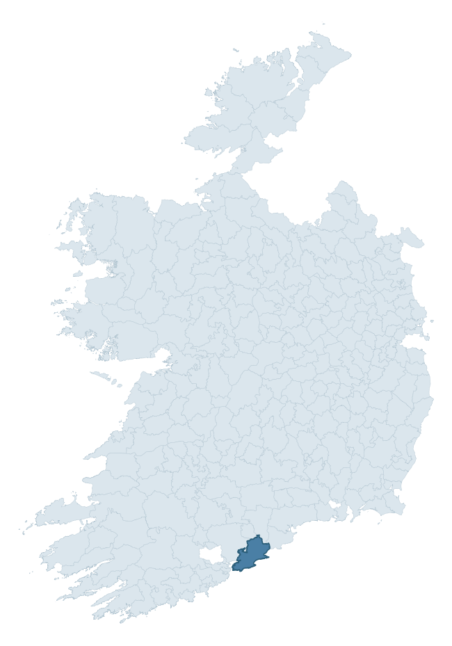
Where this barony sits in the Republic of Ireland
Geology and preservation
Bedrock geology shapes the landscape long before any settlement begins — controlling soil drainage, agricultural potential, the survival of upstanding monuments, and the preservation of buried archaeology. The figures below come from the Geological Survey Ireland 1:100,000 bedrock map.
The bedrock underlying Imokilly is predominantly limestone (35% of the barony by area), laid down during the Devonian period (55% by area, around 419 to 359 million years ago). Limestone is the most heritage-rich bedrock in Ireland. It supports fertile, well-drained soils that favoured dense Early Medieval settlement and Norman manorial agriculture, and it weathers into karst features — sinkholes, caves, swallow holes, and souterrains — that frequently carry archaeology. Where peat overlies limestone, organic preservation can be exceptional. A substantial secondary geology of mudstone (34%) and sandstone (20%) adds further variety to the underlying landscape. The single largest mapped unit is the Ballytrasna Formation (34% of the barony's bedrock).
Rock type composition
Largest mapped unit: Ballytrasna Formation (34% of the barony)
Placename evidence
Logainm records 68 heritage-diagnostic placenames for Imokilly, drawn from townland and civil-parish names across the barony. The dominant stratum is Early Christian ecclesiastical — cill-, teampall-, and domhnach-prefixed names that record the dense network of early church foundations established between the fifth and tenth centuries. The leading diagnostic roots are cill- (32 — church), ráth- (13 — earthen ringfort), and dún- (7 — hilltop fort or promontory fort). This is well above the ROI average of 30.7 heritage placenames per barony — around 2.2× the typical figure. The presence of multiple heritage strata side by side indicates layered occupation of the landscape across successive prehistoric and historic periods. Logainm records 438 placenames for Imokilly (predominantly townland names). Of these, 68 (16%) carry one of the diagnostic Gaelic roots tracked above; the remainder draw on more generic landscape vocabulary that does not encode a heritage period.
Pre-Christian / Early Medieval Defensive
| Root | Count | Meaning |
|---|---|---|
| ráth- | 13 | earthen ringfort |
| dún- | 7 | hilltop or promontory fort |
| lios- | 6 | ringfort or enclosure |
| cathair- | 2 | stone fort |
Early Christian Ecclesiastical
| Root | Count | Meaning |
|---|---|---|
| cill- | 32 | church (early) |
| cillín- | 2 | unconsecrated burial ground |
| teampall- | 1 | church (later medieval) |
| mainistir- | 1 | monastery |
| díseart- | 1 | hermitage |
| gráinseach- | 1 | monastic farm / grange |
Burial, Ritual, and Norse-Contact
| Root | Count | Meaning |
|---|---|---|
| carn- | 1 | cairn |
| gall- | 1 | foreigner — Norse settlement marker |
Other baronies in Cork
- Kerrycurrihy
- Ibane And Barryroe
- Orrery And Kilmore
- Fermoy
- Carbery West (west Division)
- Condons And Clangibbon
- Barrymore
- Iffa And Offa West — Tipperary
- North Liberties — Limerick
- Moyarta — Clare
See all 280 baronies in the Republic of Ireland Heritage Tool.

Explore further
Grounding History: 10 Maps of Northern Ireland’s Past
If you’re interested in Irish heritage more widely, the companion report for Northern Ireland brings together the analysis of all 462 NI wards into one place through 10 high-quality maps — covering monument density, archaeological periods, placename heritage, terrain, wetland, and the historic landscape at first survey. Take a look.
About this profile
Click any section below to expand.
What is a barony?
A barony is a historic administrative unit in Ireland, broadly equivalent to an English hundred. The 280 baronies used here are from the OSi 2019 National Statutory Boundaries (generalised 20m), covering the 26 counties of the Republic of Ireland. Baronies derive from the Norman period, were formalised in the 17th century, and have not been redrawn for statistical purposes. They vary enormously in area, from compact urban baronies in Dublin to vast upland baronies in Connacht, and should not be compared by raw site count without accounting for area differences.
What counts as a site?
This profile combines three distinct heritage registers, each with its own definition of what constitutes a recordable site:
- Archaeological sites (NMS). The National Monuments Service Sites and Monuments Record (SMR) catalogues every known archaeological monument or site of archaeological interest in the Republic, from prehistoric burial mounds and ringforts to medieval churches and post-medieval defensive works. Inclusion does not require legal protection — only that the site has been identified, surveyed, and assessed as having archaeological value. A separate subset of these sites lies within a recorded protection zone, which gives them statutory protection under the National Monuments Acts.
- Listed buildings (NIAH). The National Inventory of Architectural Heritage records buildings of architectural, historical, archaeological, artistic, cultural, scientific, social, or technical interest. Each surveyed structure is appraised on a five-tier scale: International, National, Regional, Local, and Record-Only. The NIAH appraisal is informational rather than strictly statutory, but it underpins local-authority Record of Protected Structures (RPS) listings.
- Heritage placenames (Logainm). Logainm is the authoritative database of Irish placenames maintained by the Placenames Branch. This profile applies a heritage-diagnostic classifier to the Irish-language form of each townland name, flagging roots that signal defensive sites (ráth-, lios-, dún-, caiseal-, cathair-), ecclesiastical foundations (cill-, teampall-, domhnach-, mainistir-), prehistoric burial-ritual features (tuaim-, carn-, leaba-), or Norse-contact settlement (gall-). Townlands without one of these diagnostic roots are not flagged here — they may still carry historical significance, but that significance is not encoded in the name itself.
Editorial principles
The narrative sections of this profile follow several explicit principles:
- Evidential. Every claim about this barony’s heritage character is anchored in the underlying register data. Where a site count, a placename count, or a percentile rank is cited, it is computed from the source datasets at export time, not estimated.
- Comparative. Counts and metrics are reported alongside their percentile rank against the other 279 ROI baronies. A barony with 50 ringforts in absolute terms could be unusually high or unusually low depending on its size and regional context; percentile ranking removes that ambiguity.
- Transparent on limits. Where a register has known coverage gaps, survey biases, or data-quality issues that affect this barony’s figures, the profile flags them rather than presenting the numbers as definitive.
- No interpretation beyond what the data supports. The narrative does not speculate about historical events, social dynamics, or cultural meaning beyond what the recorded heritage and placename evidence directly attests.
Data caveats and limits
- NMS Sites and Monuments Record is the product of survey campaigns conducted at different intensities across different counties and decades. Some baronies have been surveyed more thoroughly than others, and absolute counts should be read in that light. Sites destroyed by development before survey are typically not represented; sites in heavily forested or upland terrain are sometimes under-recorded.
- NIAH coverage is broadly complete for the Republic of Ireland but the survey was conducted on a rolling county-by-county basis, and the most recent appraisal date varies. Buildings demolished or substantially altered after their original survey may still appear in the register; conversely, recent buildings of merit may not yet have been appraised.
- Logainm classification applies a deliberately conservative pattern-matching approach to the Irish-language townland forms. The classifier prioritises true positives over recall: a townland may carry a heritage signal that the classifier doesn’t recognise, particularly where the diagnostic root has been heavily anglicised or where the townland name draws on a less common term. The 60,000+ townland records and ~9,800 classified placenames give a substantial signal at barony scale, but individual townland names should be checked against Logainm directly for definitive interpretation.
- Period attribution. The chronological distribution reflects only those NMS sites that carry a recognised period attribution in the source data. Sites listed as “Unknown” period are excluded from the dated subset.
- Boundary changes. Some baronies have undergone minor boundary adjustments since their 19th-century definition; the OSi 2019 generalised boundaries used here are the current statutory definition and may differ slightly from historical maps in border areas.
- Bedrock geology is mapped at 1:100,000 scale, which means local variation within a barony — small pockets of different rock type, mineral veins, alluvium overlying bedrock — is generalised. The dominant-system and rocktype figures are area-weighted, so a barony reading “70% Carboniferous limestone” may still contain small but archaeologically important pockets of older or younger rock. Around 3% of GSI polygons do not match the lexicon and contribute no rocktype or system attribution.
Data sources
- National Monuments Service — Sites and Monuments Record (SMR) https://data.gov.ie/dataset/national-monuments-service-archaeological-survey-of-ireland
- National Inventory of Architectural Heritage (NIAH) https://data.gov.ie/dataset/national-inventory-of-architectural-heritage-niah-national-dataset
- Logainm — Placenames Database of Ireland https://www.logainm.ie/
- Ordnance Survey Ireland — National Statutory Barony Boundaries 2019 https://data-osi.opendata.arcgis.com/
- EURODEM — European Digital Elevation Model https://www.mapsforeurope.org/datasets/euro-dem
- ESA WorldCover https://esa-worldcover.org/en
- Geological Survey Ireland — 1:100,000 Bedrock Geology https://www.gsi.ie/en-ie/data-and-maps/Pages/Bedrock.aspx
Explore more: Search any of the 280 ROI baronies, browse by historical province, or read the methodology and data sources for the full Republic of Ireland Heritage Tool.