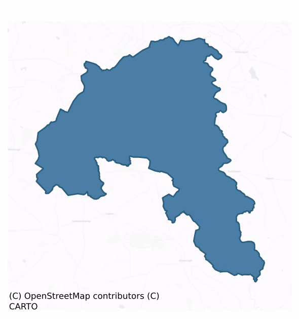
Killian is a barony of County Galway, in the historical province of Connacht (Irish: Cill Liatháin), covering 213 km² of land. The barony records 335 NMS archaeological sites and 40 NIAH listed buildings, placing it at around the 37th percentile among 280 ROI baronies for sites per km². This means it is in the lower half of all baronies for sites per km². Dated archaeological evidence runs from the Early Bronze Age through to the Modern, spanning 6 of 9 archaeological periods, placing the barony in the 10th percentile among 280 ROI baronies for chronological depth. This means it is in the bottom fifth of all baronies for chronological depth. The largest dated subset of recorded sites dates to the Early Medieval. Logainm flags 24 placenames in the barony as carrying a recognised heritage root; the largest share — around 50% — are names associated with early Christian church and monastic foundations.
Heritage at a glance
Percentile rankings throughout this profile compare each barony only against the other 279 Republic of Ireland baronies.
The recorded heritage of Killian
The National Monuments Service Sites and Monuments Record (SMR) is the statutory inventory of archaeological sites for the Republic of Ireland, maintained by the Department of Tourism, Culture, Arts, Gaeltacht, Sport and Media. Sites recorded here include earthworks, ringforts, megalithic tombs, ecclesiastical remains, and post-medieval features; not every record is legally protected, but each is registered as a monument of archaeological interest.
The National Monuments Service records 335 archaeological sites in Killian, putting it at the 37th percentile among 280 ROI baronies for sites per km². This means it is in the lower half of all baronies for sites per km². Of these, 216 (64%) fall within a recorded monument protection zone. The record is dominated by defensive sites — ringforts, enclosures, hillforts, and stone forts (86 sites, 26% of the total), with industrial sites forming a substantial secondary presence (42 sites, 13%). Quarry is the most prevalent type, making up 13% of the barony's recorded sites (42 records) — well above the ROI average of 4% across all baronies where this type occurs. Quarry is a place where stone, sand, gravel or clay was extracted. Other significant types include Enclosure (27) and Ringfort – unclassified (25). Enclosure is a banked or ditched feature of uncertain type, used as a catch-all where the original function cannot be determined from surface evidence; Ringfort – unclassified is a circular Early Medieval settlement enclosure where surviving evidence does not allow distinction between earthen and stone forms. Across the barony's 213 km², this gives a recorded density of 1.58 sites per km².
Most common monument types
Hover or tap a monument type to see its definition.
| Type | Count |
|---|---|
| Quarry a place where stone, sand, gravel or clay was extracted | 42 |
| Enclosure a banked or ditched feature of uncertain type, used as a catch-all where the original function cannot be determined from surface evidence | 27 |
| Ringfort – unclassified a circular Early Medieval settlement enclosure where surviving evidence does not allow distinction between earthen and stone forms | 25 |
| Ringfort – rath an earthen ringfort enclosed by a bank and external ditch — the most common Early Medieval farmstead, broadly dated 500–1000 AD | 23 |
Chronological distribution
The dated archaeological record for Killian spans from the Early Bronze Age through to the Modern, with activity attested across 6 of 9 archaeological periods. This is the 10th percentile across ROI baronies — a relatively narrow chronological band, with much of Irish prehistory not represented in the dated record. The record is near-continuous, with only the Middle Late Bronze Age period falling inside the span without any recorded sites. Activity concentrates most heavily in the Early Medieval (64 sites, 47% of dated material), with the Iron Age forming a secondary peak (42 sites, 31%). A further 200 recorded sites (60% of the overall NMS register for the barony) carry no period attribution — appearing as 'Unknown' in the bar chart below. This typically reflects either records that pre-date the standardised period vocabulary or sites awaiting specialist dating review, rather than a genuine absence of chronological evidence.
Sample of recorded monuments
Show 25 sample monuments (of 335 total)
A representative sample of 25 recorded monuments drawn from the barony’s 335 total NMS entries. Sites within a recorded monument protection zone and rarer site types are prioritised so the list shows a meaningful cross-section rather than only the most common type. Each entry shows the official Sites and Monuments Record reference number and the description published by the National Monuments Service.
Barrow – ring-barrow
In flat farmland, formerly part of the demesne of Castle Kelly. An overgrown circular barrow (D 46.6m ext.), in fair condition, comprising a flat central area (D 22.1m, H c. 0.5m) encircled by an internal fosse and…
In flat farmland, formerly part of the demesne of Castle Kelly. An overgrown circular barrow (D 46.6m ext.), in fair condition, comprising a flat central area (D 22.1m, H c. 0.5m) encircled by an internal fosse and external bank.
The above description is derived from the published 'Archaeological Inventory of County Galway Vol. II – North Galway'. Compiled by Olive Alcock, Kathy de hÓra and Paul Gosling (Dublin: Stationery Office, 1999).
Date of upload: 05 August 2010
Fish-pond
The Archaeological Survey of Ireland (ASI) is in the process of providing information on all monuments on The Historic Environment Viewer (HEV). Currently the information for this record has not been uploaded. To…
The Archaeological Survey of Ireland (ASI) is in the process of providing information on all monuments on The Historic Environment Viewer (HEV). Currently the information for this record has not been uploaded. To access available information for research purposes please make an appointment in advance with the Archive Unit (open Fridays 10.00 am – 5.00 pm), Department of Culture, Heritage and the Gaeltacht, The Custom House, Dublin 1 D01W6XO or email nmarchive@chg.gov.ie.
Castle – unclassified
In level grassland W of Ballygar village. In existence in 1574 when 'Beallagharee' castle was in the possession of 'Hugh McTirilagh' (Nolan 1901b, 119). According to OS Letters (O'Flanagan 1927, Vol. 1, 112), it…
In level grassland W of Ballygar village. In existence in 1574 when 'Beallagharee' castle was in the possession of 'Hugh McTirilagh' (Nolan 1901b, 119). According to OS Letters (O'Flanagan 1927, Vol. 1, 112), it belonged to the 'Blakes'. Apart from a faint rise in the ground surface, no visible surface trace survives.
The above description is derived from the published 'Archaeological Inventory of County Galway Vol. II – North Galway'. Compiled by Olive Alcock, Kathy de hÓra and Paul Gosling (Dublin: Stationery Office, 1999).
Date of upload: 05 August 2010
Monumental structure
The Archaeological Survey of Ireland (ASI) is in the process of providing information on all monuments on The Historic Environment Viewer (HEV). Currently the information for this record has not been uploaded. To…
The Archaeological Survey of Ireland (ASI) is in the process of providing information on all monuments on The Historic Environment Viewer (HEV). Currently the information for this record has not been uploaded. To access available information for research purposes please make an appointment in advance with the Archive Unit (open Fridays 10.00 am – 5.00 pm), Department of Culture, Heritage and the Gaeltacht, The Custom House, Dublin 1 D01W6XO or email nmarchive@chg.gov.ie.
Cross
The Archaeological Survey of Ireland (ASI) is in the process of providing information on all monuments on The Historic Environment Viewer (HEV). Currently the information for this record has not been uploaded. To…
The Archaeological Survey of Ireland (ASI) is in the process of providing information on all monuments on The Historic Environment Viewer (HEV). Currently the information for this record has not been uploaded. To access available information for research purposes please make an appointment in advance with the Archive Unit (open Fridays 10.00 am – 5.00 pm), Department of Culture, Heritage and the Gaeltacht, The Custom House, Dublin 1 D01W6XO or email nmarchive@chg.gov.ie.
Icehouse
The Archaeological Survey of Ireland (ASI) is in the process of providing information on all monuments on The Historic Environment Viewer (HEV). Currently the information for this record has not been uploaded. To…
The Archaeological Survey of Ireland (ASI) is in the process of providing information on all monuments on The Historic Environment Viewer (HEV). Currently the information for this record has not been uploaded. To access available information for research purposes please make an appointment in advance with the Archive Unit (open Fridays 10.00 am – 5.00 pm), Department of Culture, Heritage and the Gaeltacht, The Custom House, Dublin 1 D01W6XO or email nmarchive@chg.gov.ie.
Kiln – lime
In a natural depression in pastureland. Marked on 3rd ed. of OS 6-inch map (1932) as a small circular mound (D c. 15m). What is visible is a poorly preserved and partially overgrown circular mound (D c. 9m, H c. 1m) at…
In a natural depression in pastureland. Marked on 3rd ed. of OS 6-inch map (1932) as a small circular mound (D c. 15m). What is visible is a poorly preserved and partially overgrown circular mound (D c. 9m, H c. 1m) at S end of the depression. There is a hollow in its centre and a pile of loose rubble at its N end. Possibly a limekiln.
The above description is derived from the published 'Archaeological Inventory of County Galway Vol. II – North Galway'. Compiled by Olive Alcock, Kathy de hÓra and Paul Gosling (Dublin: Stationery Office, 1999).
Date of upload: 05 August 2010
Bridge
Straddling the Shiven River, this nine-arch bridge is described as follows in the National Inventory of Architectural Heritage: 'Nine-arch road over water bridge, built c.1830. Segmental arches with cut limestone…
Straddling the Shiven River, this nine-arch bridge is described as follows in the National Inventory of Architectural Heritage: 'Nine-arch road over water bridge, built c.1830. Segmental arches with cut limestone voussoirs to arch rings, coursed random rubble limestone to spandrels. Triangular cutwaters with ashlar piers and pyramidal limestone caps. Random rubble limestone parapet with flat cement coping to west side. Crenellated screen wall to east side with cylindrical turrets to each end and one to riverbank, triangular coping to merlons, flat limestone coping to wall. Projecting chamfered string course below crenellations, crenellated parapet to turrets supported on stone brackets. Tarmacadamed carriageway with concrete kerbs. Random rubble limestone walls to adjacent fields, with pointed-arch pedestrian gateway to south-west. Carrying traffic over the River Shiven, this unusual bridge has been part of the infrastructure of the area for over a hundred and fifty years. The crenellated screen wall with its turrets is a unique and attractive feature of the bridge. There is evidence that the screen wall is a later addition and was built on top of an existing parapet which matched the west face. A whimsical addition to the local architectural heritage, this bridge is also a fine example of nineteenth-century stonework and a valuable asset to the industrial heritage of the area' (http://www.buildingsofireland.ie/niah accessed 3 April 2017).
Compiled by: Olive Alcock
D…
Enclosure – large enclosure
On a ridge in gently undulating grassland. Poorly preserved oval enclosure (N-S 75m, E-W 56m) defined by a degraded bank and external fosse from SW to N. Traces of an outer bank are suggested by a berm which is evident…
On a ridge in gently undulating grassland. Poorly preserved oval enclosure (N-S 75m, E-W 56m) defined by a degraded bank and external fosse from SW to N. Traces of an outer bank are suggested by a berm which is evident from NW to ENE. Quarrying has disturbed the interior and destroyed most of the internal face of the bank. This monument also extends on to OS sheet 74 (GA074-001—-).
The above description is derived from the published 'Archaeological Inventory of County Galway Vol. II – North Galway'. Compiled by Olive Alcock, Kathy de hÓra and Paul Gosling (Dublin: Stationery Office, 1999).
Updated by: Olive Alcock
Date of revised upload: 25 October 2022
Crucifixion plaque
This crucifixion plaque (H 0.6m; Wth 0.44m; T 0.15m) has been placed against the external face of the enclosing wall of the holy well (GA061-023) at NE. It bears the figure of Christ on the cross and symbols of the…
This crucifixion plaque (H 0.6m; Wth 0.44m; T 0.15m) has been placed against the external face of the enclosing wall of the holy well (GA061-023) at NE. It bears the figure of Christ on the cross and symbols of the Passion, including a ladder, hammer and pincers, are also visible. A narrow border runs around all four sides of it. It dates from the late 18th century or early 19th century (pers. comm. J. Higgins).
Compiled by: Olive Alcock
Date of upload: 24 March 2020
The monument was taken into Ownership under the National Monuments Acts 1930 to 2014 – National Monument 467.
Headstone
Some 50m N of a CBG (GA032-006—-). Marked on 1st ed. of OS 6-inch map as 'St. Brendan's Grave and Well'.
On inspection in July 1984, two holy wells were recorded here: (a, GA032-043—-) a natural spring, dried up…
Some 50m N of a CBG (GA032-006—-). Marked on 1st ed. of OS 6-inch map as 'St. Brendan's Grave and Well'.
On inspection in July 1984, two holy wells were recorded here: (a, GA032-043—-) a natural spring, dried up at the time of visit, enclosed by a circular drystone wall (D 1.15m) with an entrance at W, and (b, GA032-043001-) 1m to S, another dried-up spring well enclosed by a square mortared wall (L/Wth 2.5m) with an entrance at SE. A stone-lined overflow channel ran beneath the entrance. The 3rd ed. of OS 6-inch map (1931) depicted a circular pathway surrounding the wells, no visible surface of it trace survived. Some 7m to the W, a 17/18th-C inscribed limestone slab (GA032-043002-), depicting a crucifixion, reputedly marked the grave of St Brendan. The wells and slab subsequently underwent some works up by a local group. (O'Flanagan 1927, Vol. 1, 108-9)
The above description is derived from the published 'Archaeological Inventory of County Galway Vol. II – North Galway'. Compiled by Olive Alcock, Kathy de hÓra and Paul Gosling (Dublin: Stationery Office, 1999).
The following image was uploaded: GA032-043002-_05.jpg
Updated by: Olive Alcock
Date of revised upload: 26 June 2023
Ecclesiastical site
Within an early ecclesiastical enclosure (GA033-050004-); it stood in SE section of the now disused graveyard. Marked on 1st ed. of OS 6-inch map as a rectangular area, aligned N-S, defined by a broken line. No visible…
Within an early ecclesiastical enclosure (GA033-050004-); it stood in SE section of the now disused graveyard. Marked on 1st ed. of OS 6-inch map as a rectangular area, aligned N-S, defined by a broken line. No visible surface trace of it survives. The graveyard, roughly square in plan (L/Wth c. 30m), is enclosed by a poorly preserved bank of earth and stone. Apart from a small number of randomly placed stones, there is no visible surface trace of any grave-markers.
The above description is derived from the published 'Archaeological Inventory of County Galway Vol. II – North Galway'. Compiled by Olive Alcock, Kathy de hÓra and Paul Gosling (Dublin: Stationery Office, 1999).
Date of upload: 05 August 2010
Bullaun stone
The Archaeological Survey of Ireland (ASI) is in the process of providing information on all monuments on The Historic Environment Viewer (HEV). Currently the information for this record has not been uploaded. To…
The Archaeological Survey of Ireland (ASI) is in the process of providing information on all monuments on The Historic Environment Viewer (HEV). Currently the information for this record has not been uploaded. To access available information for research purposes please make an appointment in advance with the Archive Unit (open Fridays 10.00 am – 5.00 pm), Department of Culture, Heritage and the Gaeltacht, The Custom House, Dublin 1 D01W6XO or email nmarchive@chg.gov.ie.
Workhouse
The following description is derived from the National Inventory of Architectural Heritage, http://www.buildingsofireland.ie/niah/search.jsp?type=record&county=GA®no=30404621#(last accessed 2 November 2018):
Pair…
The following description is derived from the National Inventory of Architectural Heritage, http://www.buildingsofireland.ie/niah/search.jsp?type=record&county=GA®no=30404621#(last accessed 2 November 2018):
Pair of detached fourteen-bay two-storey workhouse buildings, built c.1860, now in use as school, blocks connected by ashlar stone wall with single-storey pitched roof former dining hall, and with two-storey extension to rear of north-west block at right angles. Hipped slate roof, replacement slate to south-east block, and cast-iron rainwater goods. Roughcast rendered walls with render skirting above painted draughted and pecked stone plinth. Square-headed window openings with slim rendered reveals, painted sills and replacement uPVC windows throughout. Square-headed entrance opening to central bay of each block with bullnosed splayed limestone surrounds. Segmental-headed timber sheeted door to south-east block with draughted and pecked limestone surround. Single-storey squared and snecked limestone wall with flat stone copings and central segmental arch with draughted and pecked stone surround joining both blocks. Three-bay rendered gable-fronted former dining hall with bellcote to gable perpendicular to schoolhouse blocks, having pitched slate roof, replacement uPVC rainwater goods, square-headed openings, replacement uPVC windows throughout and segmental-headed timber entrance door to south-west gable with painted stone surround. Set back from road with mature…
Road – road/trackway
The Archaeological Survey of Ireland (ASI) is in the process of providing information on all monuments on The Historic Environment Viewer (HEV). Currently the information for this record has not been uploaded. To…
The Archaeological Survey of Ireland (ASI) is in the process of providing information on all monuments on The Historic Environment Viewer (HEV). Currently the information for this record has not been uploaded. To access available information for research purposes please make an appointment in advance with the Archive Unit (open Fridays 10.00 am – 5.00 pm), Department of Culture, Heritage and the Gaeltacht, The Custom House, Dublin 1 D01W6XO or email nmarchive@chg.gov.ie.
Religious house – Carmelite friars
At S end of a long low hill in pastureland, it stands on N side of a rectangular graveyard (GA061-080002-). This medieval monastery, the earliest documentary record of which occurs in 1436-7, appears to have been…
At S end of a long low hill in pastureland, it stands on N side of a rectangular graveyard (GA061-080002-). This medieval monastery, the earliest documentary record of which occurs in 1436-7, appears to have been founded as a Carmelite house, possibly becoming Franciscan later (Connellan 1943b, 15-21; Gwynn and Hadcock 1970, 280, 289). What is visible are the partially ivy-clad remains of a church in fair condition, along with the poorly preserved remains of a cloister garth and a domestic wing. Of the rectangular church (E-W; L 26m, Wth 6.5m), most of its walls still stand, albeit partially rebuilt and punctuated by a number of modern gaps. The original doorway, now robbed out and blocked up, was in W gable: it contains a water font in S jamb of its embrasure. The W jamb of another doorway is also visible in the masonry towards W end of N wall: it probably gave access to the cloister area. The partially blocked embrasure of a small robbed-out window is visible at E end of S wall. Connellan (ibid. 20) mentions a 'sedilia … to the right [W] of this window' of which no definite trace survives. A large ragged ope marks the site of E window 'where, forty years ago, stood a fine spacious window of four lights … in the pointed style and of cut stone' (ibid.). A rectangular cloister area (E-W; L 20m, Wth 13.7m) abuts the church to N with a small annexe or cell (L 7m, Wth 5m) at its NW corner. Little survives of the claustral area. It was flanked along E side by a two-storey d…
Standing stone
The Archaeological Survey of Ireland (ASI) is in the process of providing information on all monuments on The Historic Environment Viewer (HEV). Currently the information for this record has not been uploaded. To…
The Archaeological Survey of Ireland (ASI) is in the process of providing information on all monuments on The Historic Environment Viewer (HEV). Currently the information for this record has not been uploaded. To access available information for research purposes please make an appointment in advance with the Archive Unit (open Fridays 10.00 am – 5.00 pm), Department of Culture, Heritage and the Gaeltacht, The Custom House, Dublin 1 D01W6XO or email nmarchive@chg.gov.ie.
Road – unclassified togher
The Archaeological Survey of Ireland (ASI) is in the process of providing information on all monuments on The Historic Environment Viewer (HEV). Currently the information for this record has not been uploaded. To…
The Archaeological Survey of Ireland (ASI) is in the process of providing information on all monuments on The Historic Environment Viewer (HEV). Currently the information for this record has not been uploaded. To access available information for research purposes please make an appointment in advance with the Archive Unit (open Fridays 10.00 am – 5.00 pm), Department of Culture, Heritage and the Gaeltacht, The Custom House, Dublin 1 D01W6XO or email nmarchive@chg.gov.ie.
Castle – tower house
The Archaeological Survey of Ireland (ASI) is in the process of providing information on all monuments on The Historic Environment Viewer (HEV). Currently the information for this record has not been uploaded. To…
The Archaeological Survey of Ireland (ASI) is in the process of providing information on all monuments on The Historic Environment Viewer (HEV). Currently the information for this record has not been uploaded. To access available information for research purposes please make an appointment in advance with the Archive Unit (open Fridays 10.00 am – 5.00 pm), Department of Culture, Heritage and the Gaeltacht, The Custom House, Dublin 1 D01W6XO or email nmarchive@chg.gov.ie.
Crannog
In Ballaghdacker Lough. An oval tree-covered island (E-W 90m, N-S 60m) composed of small stones and standing c. 2m above the present water level. A possible causeway is visible at E. Another crannog (GA020-011—-) lies…
In Ballaghdacker Lough. An oval tree-covered island (E-W 90m, N-S 60m) composed of small stones and standing c. 2m above the present water level. A possible causeway is visible at E. Another crannog (GA020-011—-) lies c. 100m to N.
The above description is derived from the published 'Archaeological Inventory of County Galway Vol. II – North Galway'. Compiled by Olive Alcock, Kathy de hÓra and Paul Gosling (Dublin: Stationery Office, 1999).
Date of upload: 05 August 2010
Crannog
In Ballaghdacker Lough close to N shore. An overgrown circular earthen platform (D 28m, H 1.75m). A curving causeway connects the monument to N shore of the lake. A possible crannog (GA020-001—-) lies c. 100m to…
In Ballaghdacker Lough close to N shore. An overgrown circular earthen platform (D 28m, H 1.75m). A curving causeway connects the monument to N shore of the lake. A possible crannog (GA020-001—-) lies c. 100m to S.
The above description is derived from the published 'Archaeological Inventory of County Galway Vol. II – North Galway'. Compiled by Olive Alcock, Kathy de hÓra and Paul Gosling (Dublin: Stationery Office, 1999).
Date of upload: 05 August 2010
Well
In marsh and bogland. Marked and named in Gothic script on 1st ed. of OS 6-inch map but on 3rd ed. (1932), it appears in Roman script. A natural spring well enclosed by a collapsed roughly squared-off drystone wall…
In marsh and bogland. Marked and named in Gothic script on 1st ed. of OS 6-inch map but on 3rd ed. (1932), it appears in Roman script. A natural spring well enclosed by a collapsed roughly squared-off drystone wall (L/Wth 3m) which has been badly disturbed by cattle. According to local tradition, a horse drowned here and as a result the well is known locally as 'Tobar na gCapaill'. A CBG (GA047-009—-) and a holy well (GA047-007—-) lie c. 170m to SW.
The above description is derived from the published 'Archaeological Inventory of County Galway Vol. II – North Galway'. Compiled by Olive Alcock, Kathy de hÓra and Paul Gosling (Dublin: Stationery Office, 1999).
Date of upload: 05 August 2010
Building
On a byroad in flat grassland. Named on 1st ed. of OS 6-inch map as 'R.C. Chapel' but on 3rd ed. (1932) as a Franciscan foundation. However, Gwynn and Hadcock (1970, 281) state that there is 'no trustworthy evidence for…
On a byroad in flat grassland. Named on 1st ed. of OS 6-inch map as 'R.C. Chapel' but on 3rd ed. (1932) as a Franciscan foundation. However, Gwynn and Hadcock (1970, 281) state that there is 'no trustworthy evidence for a … friary here.' The present remains consist of the shell of a rectangular building, aligned N-S. The N gable contains a blocked doorway with a small window above it. There is also a second, partially blocked, doorway in E wall. Of pointed arch form, it is flanked by two pointed arch windows and surmounted by a decorated plaque of 18th- or 19th-C date bearing an inscription in Latian.
The above description is derived from the published 'Archaeological Inventory of County Galway Vol. II – North Galway'. Compiled by Olive Alcock, Kathy de hÓra and Paul Gosling (Dublin: Stationery Office, 1999).
Date of upload: 05 August 2010
Designed landscape – folly
On a low hilltop. A well-preserved folly (D 2.8m, H c. 12m), of roughly coursed and mortared limestone boulders, built in the style of a round tower. There is a string course below the corbelled roof cap. The structure…
On a low hilltop. A well-preserved folly (D 2.8m, H c. 12m), of roughly coursed and mortared limestone boulders, built in the style of a round tower. There is a string course below the corbelled roof cap. The structure is apparently solid as there are no doorway or window openings. A plaque at SW reads 'Built in 1776'. Possibly associated with Castlegar House which lies c. 1km to NW.
The above description is derived from the published 'Archaeological Inventory of County Galway Vol. II – North Galway'. Compiled by Olive Alcock, Kathy de hÓra and Paul Gosling (Dublin: Stationery Office, 1999).
Date of upload: 05 August 2010
Quarry
A hachured feature marked on the 1931 edition of the OS 6-inch map proved on inspection in 1984 to be a disused gravel pit defined by a hollow. Probably of 19th/20th century date.
Compiled by: Olive Alcock…
A hachured feature marked on the 1931 edition of the OS 6-inch map proved on inspection in 1984 to be a disused gravel pit defined by a hollow. Probably of 19th/20th century date.
Compiled by: Olive Alcock
Date of upload: 2 October 2014
Listed buildings
The National Inventory of Architectural Heritage (NIAH) is a state survey appraising buildings of architectural, historical, archaeological, artistic, cultural, scientific, social, or technical interest. Each surveyed structure receives a rating from International (the highest, for buildings of European importance) through National, Regional, Local, and Record-Only.
The NIAH records only 40 listed buildings in Killian, the 19th percentile across ROI baronies — a relatively thin architectural record. The highest-graded structure include 1 of National significance. The Republic holds 937 National-graded buildings in total, so this barony accounts for around 0% of the national total. Construction dates concentrate most heavily in the Victorian (1830-1900) period. The most-recorded building type is bridge (11 examples, 28% of the listed stock).
Terrain and environment
Mean elevation across the barony is 59m — the 21st percentile among 280 ROI baronies for elevation. This means it is in the bottom third of all baronies for elevation. This is a relatively low-lying landscape by ROI standards. Elevation matters for heritage because higher-altitude baronies typically favour defensive monuments — ringforts and hilltop forts placed on prominent ground — while lowland baronies are more likely to carry the dense settlement and church networks of intensive agricultural landscapes. A maximum elevation of 162m gives the barony meaningful vertical relief. Mean slope is 2.2° — the 12th percentile among 280 ROI baronies for slope. This means it is in the bottom fifth of all baronies for slope. This is broadly flat terrain, the kind of landscape best suited to intensive agriculture. Slope is a key control on both land use and archaeological preservation: steep ground resists ploughing and tends to preserve earthworks intact, while gentle slopes favour intensive cultivation that damages or destroys surface archaeology over time. The Topographic Wetness Index averages 11.8, the 90th percentile among 280 ROI baronies for wetness. This means it is in the top tenth of all baronies for wetness. This is wet, slow-draining ground by ROI standards — the kind of landscape that may carry waterlogged archaeological sites of unusual preservation value. Drainage matters for heritage because poorly-drained ground preserves organic archaeology (wooden trackways, leather, textiles, and on rare occasions human remains) far better than free-draining soil; well-drained ground favours arable use but destroys organic material rapidly. The land cover is dominated by improved grassland (73%) and woodland (23%). In overall character, this is low-lying, gently-sloping terrain — characteristic of Ireland's central plain and coastal lowlands, with land use dominated by improved grassland.
Terrain measurements
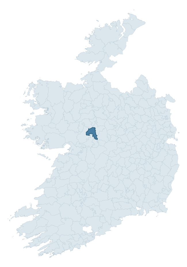
Where this barony sits in the Republic of Ireland
Geology and preservation
Bedrock geology shapes the landscape long before any settlement begins — controlling soil drainage, agricultural potential, the survival of upstanding monuments, and the preservation of buried archaeology. The figures below come from the Geological Survey Ireland 1:100,000 bedrock map.
The bedrock underlying Killian is predominantly limestones (57% of the barony by area), laid down during the Carboniferous period (100% by area, around 359 to 299 million years ago). Limestone is the most heritage-rich bedrock in Ireland. It supports fertile, well-drained soils that favoured dense Early Medieval settlement and Norman manorial agriculture, and it weathers into karst features — sinkholes, caves, swallow holes, and souterrains — that frequently carry archaeology. Where peat overlies limestone, organic preservation can be exceptional. A substantial secondary geology of limestone (32%) adds further variety to the underlying landscape. The single largest mapped unit is the Visean Limestones (undifferentiated) (57% of the barony's bedrock).
Rock type composition
Largest mapped unit: Visean Limestones (undifferentiated) (57% of the barony)
Placename evidence
Logainm records 24 heritage-diagnostic placenames for Killian, drawn from townland and civil-parish names across the barony. The dominant stratum is Early Christian ecclesiastical — cill-, teampall-, and domhnach-prefixed names that record the dense network of early church foundations established between the fifth and tenth centuries. The leading diagnostic roots are cill- (11 — church), ráth- (5 — earthen ringfort), and lios- (5 — ringfort or enclosure). This is broadly in line with the ROI average of 30.7 heritage placenames per barony. The presence of multiple heritage strata side by side indicates layered occupation of the landscape across successive prehistoric and historic periods. Logainm records 162 placenames for Killian (predominantly townland names). Of these, 24 (15%) carry one of the diagnostic Gaelic roots tracked above; the remainder draw on more generic landscape vocabulary that does not encode a heritage period.
Pre-Christian / Early Medieval Defensive
| Root | Count | Meaning |
|---|---|---|
| ráth- | 5 | earthen ringfort |
| lios- | 5 | ringfort or enclosure |
Early Christian Ecclesiastical
| Root | Count | Meaning |
|---|---|---|
| cill- | 11 | church (early) |
| mainistir- | 1 | monastery |
Burial, Ritual, and Norse-Contact
| Root | Count | Meaning |
|---|---|---|
| tuaim- | 2 | burial mound |
Other baronies in Galway
About this profile
Click any section below to expand.
What is a barony?
A barony is a historic administrative unit in Ireland, broadly equivalent to an English hundred. The 280 baronies used here are from the OSi 2019 National Statutory Boundaries (generalised 20m), covering the 26 counties of the Republic of Ireland. Baronies derive from the Norman period, were formalised in the 17th century, and have not been redrawn for statistical purposes. They vary enormously in area, from compact urban baronies in Dublin to vast upland baronies in Connacht, and should not be compared by raw site count without accounting for area differences.
What counts as a site?
This profile combines three distinct heritage registers, each with its own definition of what constitutes a recordable site:
- Archaeological sites (NMS). The National Monuments Service Sites and Monuments Record (SMR) catalogues every known archaeological monument or site of archaeological interest in the Republic, from prehistoric burial mounds and ringforts to medieval churches and post-medieval defensive works. Inclusion does not require legal protection — only that the site has been identified, surveyed, and assessed as having archaeological value. A separate subset of these sites lies within a recorded protection zone, which gives them statutory protection under the National Monuments Acts.
- Listed buildings (NIAH). The National Inventory of Architectural Heritage records buildings of architectural, historical, archaeological, artistic, cultural, scientific, social, or technical interest. Each surveyed structure is appraised on a five-tier scale: International, National, Regional, Local, and Record-Only. The NIAH appraisal is informational rather than strictly statutory, but it underpins local-authority Record of Protected Structures (RPS) listings.
- Heritage placenames (Logainm). Logainm is the authoritative database of Irish placenames maintained by the Placenames Branch. This profile applies a heritage-diagnostic classifier to the Irish-language form of each townland name, flagging roots that signal defensive sites (ráth-, lios-, dún-, caiseal-, cathair-), ecclesiastical foundations (cill-, teampall-, domhnach-, mainistir-), prehistoric burial-ritual features (tuaim-, carn-, leaba-), or Norse-contact settlement (gall-). Townlands without one of these diagnostic roots are not flagged here — they may still carry historical significance, but that significance is not encoded in the name itself.
Editorial principles
The narrative sections of this profile follow several explicit principles:
- Evidential. Every claim about this barony’s heritage character is anchored in the underlying register data. Where a site count, a placename count, or a percentile rank is cited, it is computed from the source datasets at export time, not estimated.
- Comparative. Counts and metrics are reported alongside their percentile rank against the other 279 ROI baronies. A barony with 50 ringforts in absolute terms could be unusually high or unusually low depending on its size and regional context; percentile ranking removes that ambiguity.
- Transparent on limits. Where a register has known coverage gaps, survey biases, or data-quality issues that affect this barony’s figures, the profile flags them rather than presenting the numbers as definitive.
- No interpretation beyond what the data supports. The narrative does not speculate about historical events, social dynamics, or cultural meaning beyond what the recorded heritage and placename evidence directly attests.
Data caveats and limits
- NMS Sites and Monuments Record is the product of survey campaigns conducted at different intensities across different counties and decades. Some baronies have been surveyed more thoroughly than others, and absolute counts should be read in that light. Sites destroyed by development before survey are typically not represented; sites in heavily forested or upland terrain are sometimes under-recorded.
- NIAH coverage is broadly complete for the Republic of Ireland but the survey was conducted on a rolling county-by-county basis, and the most recent appraisal date varies. Buildings demolished or substantially altered after their original survey may still appear in the register; conversely, recent buildings of merit may not yet have been appraised.
- Logainm classification applies a deliberately conservative pattern-matching approach to the Irish-language townland forms. The classifier prioritises true positives over recall: a townland may carry a heritage signal that the classifier doesn’t recognise, particularly where the diagnostic root has been heavily anglicised or where the townland name draws on a less common term. The 60,000+ townland records and ~9,800 classified placenames give a substantial signal at barony scale, but individual townland names should be checked against Logainm directly for definitive interpretation.
- Period attribution. The chronological distribution reflects only those NMS sites that carry a recognised period attribution in the source data. Sites listed as “Unknown” period are excluded from the dated subset.
- Boundary changes. Some baronies have undergone minor boundary adjustments since their 19th-century definition; the OSi 2019 generalised boundaries used here are the current statutory definition and may differ slightly from historical maps in border areas.
- Bedrock geology is mapped at 1:100,000 scale, which means local variation within a barony — small pockets of different rock type, mineral veins, alluvium overlying bedrock — is generalised. The dominant-system and rocktype figures are area-weighted, so a barony reading “70% Carboniferous limestone” may still contain small but archaeologically important pockets of older or younger rock. Around 3% of GSI polygons do not match the lexicon and contribute no rocktype or system attribution.
Data sources
- National Monuments Service — Sites and Monuments Record (SMR) https://data.gov.ie/dataset/national-monuments-service-archaeological-survey-of-ireland
- National Inventory of Architectural Heritage (NIAH) https://data.gov.ie/dataset/national-inventory-of-architectural-heritage-niah-national-dataset
- Logainm — Placenames Database of Ireland https://www.logainm.ie/
- Ordnance Survey Ireland — National Statutory Barony Boundaries 2019 https://data-osi.opendata.arcgis.com/
- EURODEM — European Digital Elevation Model https://www.mapsforeurope.org/datasets/euro-dem
- ESA WorldCover https://esa-worldcover.org/en
- Geological Survey Ireland — 1:100,000 Bedrock Geology https://www.gsi.ie/en-ie/data-and-maps/Pages/Bedrock.aspx
Explore more: Search any of the 280 ROI baronies, browse by historical province, or read the methodology and data sources for the full Republic of Ireland Heritage Tool.