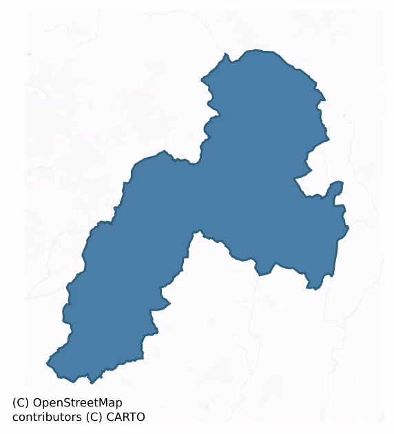
Kilnamanagh Upper is a barony of County Tipperary, in the historical province of Munster (Irish: Coill na Manach Uachtarach), covering 243 km² of land. The barony records 294 NMS archaeological sites and 51 NIAH listed buildings, placing it at around the 19th percentile among 280 ROI baronies for sites per km². This means it is in the bottom fifth of all baronies for sites per km². Dated archaeological evidence runs from the Neolithic through to the Modern, spanning 8 of 9 archaeological periods, placing the barony in the 63rd percentile among 280 ROI baronies for chronological depth. This means it is in the upper half of all baronies for chronological depth. The largest dated subset of recorded sites dates to the Iron Age. Logainm flags 23 placenames in the barony as carrying a recognised heritage root; the largest share — around 61% — are names associated with early Christian church and monastic foundations.
Heritage at a glance
Percentile rankings throughout this profile compare each barony only against the other 279 Republic of Ireland baronies.
The recorded heritage of Kilnamanagh Upper
The National Monuments Service Sites and Monuments Record (SMR) is the statutory inventory of archaeological sites for the Republic of Ireland, maintained by the Department of Tourism, Culture, Arts, Gaeltacht, Sport and Media. Sites recorded here include earthworks, ringforts, megalithic tombs, ecclesiastical remains, and post-medieval features; not every record is legally protected, but each is registered as a monument of archaeological interest.
The National Monuments Service records 294 archaeological sites in Kilnamanagh Upper, putting it at the 19th percentile among 280 ROI baronies for sites per km². This means it is in the bottom fifth of all baronies for sites per km². Protection coverage is near-universal — 289 sites (98%) fall within a recorded monument protection zone, indicating an extensively surveyed landscape. The dominant category is defensive sites — ringforts, enclosures, hillforts, and stone forts (148 sites, 50% of the record). Ringfort – rath is the most prevalent type, making up 23% of the barony's recorded sites (67 records), broadly in line with the ROI average of 20% across all baronies where this type occurs. Ringfort – rath is an earthen ringfort enclosed by a bank and external ditch — the most common Early Medieval farmstead, broadly dated 500–1000 AD. Other significant types include Enclosure (49) and Barrow – ring-barrow (21). Enclosure is a banked or ditched feature of uncertain type, used as a catch-all where the original function cannot be determined from surface evidence; Barrow – ring-barrow is a Bronze/Iron Age burial monument: a low circular area enclosed by ditch and outer bank. Across the barony's 243 km², this gives a recorded density of 1.21 sites per km².
Most common monument types
Hover or tap a monument type to see its definition.
| Type | Count |
|---|---|
| Ringfort – rath an earthen ringfort enclosed by a bank and external ditch — the most common Early Medieval farmstead, broadly dated 500–1000 AD | 67 |
| Enclosure a banked or ditched feature of uncertain type, used as a catch-all where the original function cannot be determined from surface evidence | 49 |
| Barrow – ring-barrow a Bronze/Iron Age burial monument: a low circular area enclosed by ditch and outer bank | 21 |
| Standing stone a deliberately set upright stone, used variously as a Bronze/Iron Age burial marker, route marker or commemorative monument | 16 |
| Moated site | 13 |
| Fulacht fia a horseshoe-shaped Bronze Age burnt mound built around a sunken trough beside a water source, traditionally interpreted as a cooking site | 13 |
| Church a building used for public Christian worship, of any date from c. 500 AD onwards | 9 |
Chronological distribution
The dated archaeological record for Kilnamanagh Upper spans from the Neolithic through to the Modern, with activity attested across 8 of 9 archaeological periods. Every period from earliest to latest is represented in the record — an unbroken sequence of dated activity across the full chronological span. Activity concentrates most heavily in the Iron Age (87 sites, 32% of dated material), with the Early Medieval forming a secondary peak (73 sites, 27%). A further 26 recorded sites (9% of the overall NMS register for the barony) carry no period attribution — appearing as 'Unknown' in the bar chart below. This typically reflects either records that pre-date the standardised period vocabulary or sites awaiting specialist dating review, rather than a genuine absence of chronological evidence.
Sample of recorded monuments
Show 25 sample monuments (of 294 total)
A representative sample of 25 recorded monuments drawn from the barony’s 294 total NMS entries. Sites within a recorded monument protection zone and rarer site types are prioritised so the list shows a meaningful cross-section rather than only the most common type. Each entry shows the official Sites and Monuments Record reference number and the description published by the National Monuments Service.
Cross-inscribed stone
A cross-inscribed stone found adjacent to a bullaun stone (TN027-166001). Formerly located in Moanaha Glen, immediately S of Nenagh River. The cross-inscribed stone is described as a cross-slab, irregular in shape but…
A cross-inscribed stone found adjacent to a bullaun stone (TN027-166001). Formerly located in Moanaha Glen, immediately S of Nenagh River. The cross-inscribed stone is described as a cross-slab, irregular in shape but roughly triangular in cross-section. On one face, there is a roughly equal-armed Greek cross enclosed in a double circle. The ends of the cross are expanded as T-shaped terminals. Outside the double circle the remains of an inscription are pecked on the surface of the stone. They read 'NLAD'. Before the 'N' there are faint indications of another letter but it is not possible to state with certainty what it may have been, though it may have been an 'A''. The stone is now in the care of the National Museum of Ireland. (Raftery 1967, 219-21)
The above description is derived from 'The Archaeological Inventory of County Tipperary. Vol. 1 – North Tipperary' compiled by Jean Farrelly and Caimin O'Brien (Dublin: Stationery Office, 2002). In certain instances the entries have been revised and updated in the light of recent research.
Date of upload/revision: 22 September 2008
Hillfort
Situated on a hilltop in a mountainous area with a nearby ringfort (TN028-071—-) to the E. A heather-covered hillfort (diam. 145m N-S) enclosed by a fosse (Wth 1m; D 0.2m), an earth and stone bank (Wth 2m; int. H 1m;…
Situated on a hilltop in a mountainous area with a nearby ringfort (TN028-071—-) to the E. A heather-covered hillfort (diam. 145m N-S) enclosed by a fosse (Wth 1m; D 0.2m), an earth and stone bank (Wth 2m; int. H 1m; ext. H 1m) and an outer fosse (Wth 1-3m; ext. D 0.3m) with a possible entrance gap (Wth 3m) at W. A field fence bisects the site on a N-S axis. There is no apparent attempt to flatten the interior – the natural slope of the hilltop is maintained.
The hillfort was recently described in the Atlas of Hillforts of Britain and Ireland as following; 'In commanding position surrounding domed summit of hilltop following natural contours of hill. Overlooking Moanamaddra Lough to E and Fishmoyne River to E and SE. Univallate for the entire circuit, the hillfort comprises two ditches with an intervening bank. The site has a total foot print of about 2.1ha. There is a possible entrance at the W comprising a simple 3m break in the enclosing elements. There are no other recorded entrance features. The ramparts survive well throughout its circuit. The interior is under blanket bog and heather. First map identification in second edition Ordnance Survey mapping.'(http://hillforts.arch.ox.ac.uk/records/IR0710.html)
The above description is derived from 'The Archaeological Inventory of County Tipperary. Vol. 1 – North Tipperary' compiled by Jean Farrelly and Caimin O'Brien (Dublin: Stationery Office, 2002). In certain instances the entries have been revised and updated in…
Bridge
Listed in SMR (1992) as bridge possible and in the RMP (1998) as bridge. Bridge over fast flowing river flowing W-SW in river valley. Double round arch bridge of limestone with cut limestone voussoirs. Main river now…
Listed in SMR (1992) as bridge possible and in the RMP (1998) as bridge. Bridge over fast flowing river flowing W-SW in river valley. Double round arch bridge of limestone with cut limestone voussoirs. Main river now flows through SW arch. Island in centre of river with a further single span round arch over S fork of river which has a concrete block parapet over the original cut voussoirs. This concrete parapet continues across the island up to the S arch of the pair. Wall surrounding the pair is roughly coursed limestone rubble, the parapet of which has been rebuilt and heavily pointed. Eighteenth-century bridge, flat surface of road over bridge.
S single span bridge crosses the river which runs in N-S direction and turns sharply in E-W direction to go under the bridge. The road humps over this bridge, possibly indicated an earlier date for this structure. The arch is also higher than that of the two span. The stone parapet on W side of bridge is 0.37m thick and 0.7-0.9m high. The road itself is 4.9m wide. Single span also appears eighteenth-century but it's designation on the 1st and 2nd ed. OS 6-inch map as 'Cloghinch Old Bridge', implies it may be earlier.
Compiled by: Jean Farrelly and Caimin O'Brien
Date of upload/revision: 22 September 2008
Water mill – horizontal-wheeled
An old mill was discovered in 1821 near the church (TN034-013001) (Lewis 1837, vol. 1, 654). Cooke (1822, 31) describes the circumstances and nature of the find – 'a peasant…was digging…for the purpose of levelling an…
An old mill was discovered in 1821 near the church (TN034-013001) (Lewis 1837, vol. 1, 654). Cooke (1822, 31) describes the circumstances and nature of the find – 'a peasant…was digging…for the purpose of levelling an angle of his gardens situated within a short distance of the ruins of the church…he discovered, adjoining a little stream, the remains of an ancient mill, buried in clay, a small way under the surface of the ground. He also discovered there several planks of oak from 8 to 10 feet in length and of considerable thickness, most of them being fitted with tenents and mortices apparently for the frame work of the mill'. No visible remains.
The above description is derived from 'The Archaeological Inventory of County Tipperary. Vol. 1 – North Tipperary' compiled by Jean Farrelly and Caimin O'Brien (Dublin: Stationery Office, 2002). In certain instances the entries have been revised and updated in the light of recent research.
Date of upload/revision: 22 September 2008
Historic town
Situated on flat pasture in undulating countryside. While there is no firm documentary evidence that Borrisoleigh was a medieval town its name, meaning borough of Ui Luighdheach, would suggest that it had borough…
Situated on flat pasture in undulating countryside. While there is no firm documentary evidence that Borrisoleigh was a medieval town its name, meaning borough of Ui Luighdheach, would suggest that it had borough status. References in historical sources to Borrisoleigh appear to be relating to Borris (Two-Mile-Borris) (TN042-052). The tower house (TN034-046001) in the present town belonged to the Burke family in the sixteenth century (Killanin and Duignan 1967, 123). An Inquisition taken at Clonmel in 1628 describes Borrisoleigh as the 'manor, castle, town and lands of Borres O Leagh' (Callanan 1936-9, 68). In the Civil Survey 1654-6 Borres Ileigh is described as a 'castle and Bawne of Borres in good repaire, with an orchard, a good garden, a water corne mill in repaire, six thatcht houses and many Cabbins' (Simington 1931, vol. 1, 89). A former church and graveyard (TN034-046003) at the W end of the town, levelled between 1840 and 1902-3, may have been part of the earlier settlement.
In 2002 archaeological monitoring by Anne-Marie Lennon on a single storey extension to a factory within the zone of archaeological potential revealed nothing of archaeological interest. This monitoring was carried out under Licence No. 02E0211 (Bennett 2004, 471).
The above description is derived from 'The Archaeological Inventory of County Tipperary. Vol. 1 – North Tipperary' compiled by Jean Farrelly and Caimin O'Brien (Dublin: Stationery Office, 2002). In certain instances the entrie…
Designed landscape – tree-ring
Site of destroyed tree-ring in front of 19th century house. Not depicted on 1st. ed. OS 6-inch map.
Compiled by: Jean Farrelly and Caimin O'Brien
Date of upload/revision: 22 September 2008
Hilltop enclosure
Situated on the summit of a hill in an upland area with a nearby ringfort (TN034-069—-) to NW. A large oval-shaped area (diam. 126m SE-NW; 130m NE-SW) enclosed by an earth and stone bank (Wth 1-1.5m; ext. H 2-2.5m;…
Situated on the summit of a hill in an upland area with a nearby ringfort (TN034-069—-) to NW. A large oval-shaped area (diam. 126m SE-NW; 130m NE-SW) enclosed by an earth and stone bank (Wth 1-1.5m; ext. H 2-2.5m; int. H 0.3m) mainly reduced to a scarp with no entrance feature visible. The interior maintains the natural hill slope. The external drystone wall facing of the scarp may be of nineteenth-century date. Possible hillfort reused as a landscape feature associated with nearby big house.
Recently described in the Atlas of Hillforts of Britain and Ireland as following; 'Multiple enclosure on low hilltop at E foothills of Silvermines Mountains, overlooking Cromoge River to E with panoramic views. Possible bivallate hillfort with total site footprint of 9.7ha. There are no recorded entrance features. No evidence for any internal features on the surface. Inner enclosing elements are reduced to scarp and first edition Ordnance Survey mapping indicates the rampart was much more impressive than at present. Possible concentric outer enclosing elements apparent in first edition Ordnance Survey mapping. These have been destroyed and are now only visible to the N. Interior under pasture. First map depiction in first edition Ordnance Survey 6 inch mapping. Monument surveyed by Farrelly and O'Brien (2002). Inner enclosing elements comprise a bank of earth 1.6m wide and 0.3m high with no obvious ditch feature. External drystone wall facing in some sections is likely to be of n…
Stone circle
Situated in rough terrain on a small hillock, on a SW-facing slope, overlooking a valley. A stone circle not marked on the 1sted. (1840) OS 6-inch map but depicted on the 2nd ed. (1905). There are no visible remains of…
Situated in rough terrain on a small hillock, on a SW-facing slope, overlooking a valley. A stone circle not marked on the 1sted. (1840) OS 6-inch map but depicted on the 2nd ed. (1905). There are no visible remains of the stone circle or of the standing stone (TN039-004002) also indicated at this location on the current 6-inch map.
The above description is derived from 'The Archaeological Inventory of County Tipperary. Vol. 1 – North Tipperary' compiled by Jean Farrelly and Caimin O'Brien (Dublin: Stationery Office, 2002). In certain instances the entries have been revised and updated in the light of recent research.
Date of upload/revision: 22 September 2008
Barrow – bowl-barrow
Situated on the crest of a low hill, in pasture. A roughly circular mound (base diam. 12.5m N-S; top diam. 7m; H 1.55m) enclosed by a U-shaped fosse (Wth 2.6m; D 0.5m). Whitethorns are growing on the summit and around…
Situated on the crest of a low hill, in pasture. A roughly circular mound (base diam. 12.5m N-S; top diam. 7m; H 1.55m) enclosed by a U-shaped fosse (Wth 2.6m; D 0.5m). Whitethorns are growing on the summit and around the edge of the site. There may have been quarrying into the summit at some stage (though not in memory of present landowner) with upcast around the edge of the summit to the SE and SW. A large boulder lies prostate at the outer edge of the fosse at N.
The above description is derived from 'The Archaeological Inventory of County Tipperary. Vol. 1 – North Tipperary' compiled by Jean Farrelly and Caimin O'Brien (Dublin: Stationery Office, 2002). In certain instances the entries have been revised and updated in the light of recent research.
Date of upload/revision: 22 September 2008
Castle – motte and bailey
Located on a natural ridge which is scarped steeply along the E side of the site overlooking a river valley in an upland area. Described in the Civil Survey 1654-6 as an 'old decayed castle called Gortkelly' (Simington…
Located on a natural ridge which is scarped steeply along the E side of the site overlooking a river valley in an upland area. Described in the Civil Survey 1654-6 as an 'old decayed castle called Gortkelly' (Simington 1934, vol. 2, 124). A motte and bailey with the remains of a castle (TN040-013001) surmounting the motte. A circular flat-topped mound (top diam. 23m N-S; 19.4m E-W; base diam. c. 26m N-S; c. 21m E-W; H 3.4m) with evidence of stone walling along the W edge and stone revetting on the sides of the motte. The E edge of the site is formed by a steep natural scarp. The NE portion of the motte is lowest above the exterior, being only 1.73m above the bailey. A roughly triangular bailey area to the NW of the motte is enclosed by a broad flat-topped bank (Wth 3m; int. H 0.85m; ext. H 1.72m). An external fosse (Wth 3.4m; D 1.1m) is only evident in the SW quadrant. A modern gap (Wth c. 3m) was cut through the bank of the bailey c. 2 years ago according to the landowner. The W side of the bailey is overlooked by an opposing ridge. There is a possible original entrance at the apex of the triangular-shaped bailey.
The above description is derived from 'The Archaeological Inventory of County Tipperary. Vol. 1 – North Tipperary' compiled by Jean Farrelly and Caimin O'Brien (Dublin: Stationery Office, 2002). In certain instances the entries have been revised and updated in the light of recent research.
Date of upload/revision: 22 September 2008
Water mill – unclassified
Situated W of the Clodiagh River. A water mill is marked in this area on the Down Survey parish map. The site, which stood in a farm complex, has been completely levelled and there are no visible remains.
The above…
Situated W of the Clodiagh River. A water mill is marked in this area on the Down Survey parish map. The site, which stood in a farm complex, has been completely levelled and there are no visible remains.
The above description is derived from 'The Archaeological Inventory of County Tipperary. Vol. 1 – North Tipperary' compiled by Jean Farrelly and Caimin O'Brien (Dublin: Stationery Office, 2002). In certain instances the entries have been revised and updated in the light of recent research.
Date of upload/revision: 22 September 2008
Castle – Anglo-Norman masonry castle
Situated in a low-lying river valley with the Clodiagh River running N-S c.100m to the W and a church (TN046-006001-) 400m to the N. Described in the fourteenth century as consisting of a 'stone tower roofed with…
Situated in a low-lying river valley with the Clodiagh River running N-S c.100m to the W and a church (TN046-006001-) 400m to the N. Described in the fourteenth century as consisting of a 'stone tower roofed with shingles' (Cal. inq. post mortem, no. 184). The manor of Moyaliff which was controlled by James le Botiller, Earl of Ormond, was described in 1338 as consisting of 'no edifices except a stone tower covered with shingles. Of no value because nobody wishes to hold it.' (Cal. inq. post mortem, no. 347). The burgesses of Moyaliffe held 220 acres of land for which they paid 4l 16d rent yearly (Cal. inq. post mortem, no. 347). A high, steep-sided flat-topped motte (H 8m)(TN046-006004-) the top of which is enclosed by a roughly coursed limestone castle (int. dims. 8.2m x 6.75m). No bailey area visible. The base of the walls are largely intact with the SE wall surviving 3m high. The S half of the SE wall (L 8.7m) projects out beyond the N portion (L 7.3m; wall T 1.5m). Collapsed masonry containing mural stairs is located in the castle interior. There is a garderobe chute in the W wall.
The above description is derived from 'The Archaeological Inventory of County Tipperary. Vol. 1 – North Tipperary' compiled by Jean Farrelly and Caimin O'Brien (Dublin: Stationery Office, 2002). In certain instances the entries have been revised and updated in the light of recent research.
Date of upload/revision: 22 September 2008
Castle – motte
Situated in a low-lying river valley with the Clodiagh River running N-S c. 100m to the W. Described in the fourteenth century as consisting of a 'stone tower roofed with shingles' (Cal. inq. post mortem, vol. 8, no.…
Situated in a low-lying river valley with the Clodiagh River running N-S c. 100m to the W. Described in the fourteenth century as consisting of a 'stone tower roofed with shingles' (Cal. inq. post mortem, vol. 8, no. 184). The manor of Moyaliff which was controlled by James le Botiller, Earl of Ormond, was described in 1338 as consisting of 'no edifices except a stone tower covered with shingles. Of no value because nobody wishes to hold it.' (CIPM, vol. 3, no. 347). A high, steep-sided flat-topped motte (H 8m) the top of which is enclosed by a roughly coursed limestone castle (TN046-006002-). No bailey area visible.
The above description is derived from 'The Archaeological Inventory of County Tipperary. Vol. 1 – North Tipperary' compiled by Jean Farrelly and Caimin O'Brien (Dublin: Stationery Office, 2002). In certain instances the entries have been revised and updated in the light of recent research.
Date of upload/revision: 22 September 2008
Graveslab
Situated on an E-facing slope of rising ground in an upland area with a nearby holy well site (TN034-012) to the W. Founded by St Culan in the seventh century (Gwynn and Hadcock 1970, 385). The bell shrine of St Culan,…
Situated on an E-facing slope of rising ground in an upland area with a nearby holy well site (TN034-012) to the W. Founded by St Culan in the seventh century (Gwynn and Hadcock 1970, 385). The bell shrine of St Culan, a twelfth-century reliquary, was found in a nearby hollow tree (Cooke 1822, 33-9) close to the site of the holy well. The poorly preserved remains of a nave and chancel church (TN034-013001), the chancel of which is totally destroyed, with partial remains of the N and S walls and the W gable fully intact. A memorial plaque (TN034-013005) and graveslab dedicated to Walter Burke of Illeigh erected in 1626 by Patrick Kerin (White 1892, 33) is inserted into the E end of the N wall of the nave. An old mill (TN034-013002) was discovered in 1821 near the church. Church (TN034-013001) located on top of high ground in centre of large graveyard (TN034-013003) enclosed by a 19th century wall. Memorials of 18th and 19th century date contained within graveyard.
The Latin inscription on the graveslab reads Hoed sibi monementum. Fieri fecit in eoque sepultus est Walterus de Burgo, Territorii De Illeagh, Quondam validus ac prudens propugnator qui obiit Junii 10 – Aetates Annoque Domini uxorem Habuit Jiliam filiam Ydhir, Et qua Multum suscepit. Problem 4 scilicet filios, Theobaldum Gulielum, Milerum et Johanem, Et Multas filias omnesque Lectissimis conpigibus collocatas Spes mea in Deo mes.
English Translation reads
Walter de Burgh of the territory of Illeagh, cause…
Stone row
Situated in pasture on SE facing slope of rising fround in upland area with good views of mountian valley to S and E, higher ground to N. Nearby wedge tomb (TN039-009) to NNW and fulacht fiadh (TN 039-051) to SE.…
Situated in pasture on SE facing slope of rising fround in upland area with good views of mountian valley to S and E, higher ground to N. Nearby wedge tomb (TN039-009) to NNW and fulacht fiadh (TN 039-051) to SE. Monument consists of two low limestone orthostats, aligned E-W, and 2.48m apart. Both stones are roughly triangular in shape with rectangular sections and the tops of the stones are tapering towards a point. The W stone measures 0.9m H; 0.58m x 0.21m. The E stone measures 0.8m H; 0.60m x 0.30m. Local landowner has no recollection that they were ever erected as scratching posts for livestock.
Compiled by: Caimin O'Brien.
Date of upload: 22 September 2008
Cairn – ring-cairn
On a gentle SW-facing slope of rising ground in upland region overlooking the Gortnageragh river valley from S to W. Directly N of the ring-cairn there is an outlying low orthostat (TS045-001002-). Monument consists of…
On a gentle SW-facing slope of rising ground in upland region overlooking the Gortnageragh river valley from S to W. Directly N of the ring-cairn there is an outlying low orthostat (TS045-001002-). Monument consists of a low circular rise (diam. 18m SW-NE; 19.5m NW-SE; H 0.3) of loosely piled stones or low orthostats (avg. dims. 1m x 0.5m) which in places consists of double rows of orthostats defining the perimeter of the monument which may represent internal and external kerbing containing cairn material, indicative of a poorly preserved ring-cairn. The interior is fairly open with several low mounds of loosely piled stones. In the OS Namebook (1840) the ring-cairn is described as a fort which 'has a sepulchral chamber inside it' (O'Donovan et. al.) while its local name Rathnacloghal fort is translated as the fort of the white stones.
Compiled by: Jean Farrelly
Date of upload: 26 August 2011
Barrow – mound barrow
On shelf of SE-facing hillslope in upland region overlooking river valley from ENE through E to S. Monument consists of a low flat-topped mound (top diam. 7.5m SE-NW; base diam. 10.5m SE-NW; H at NW 0.7m; H at SE 2m) of…
On shelf of SE-facing hillslope in upland region overlooking river valley from ENE through E to S. Monument consists of a low flat-topped mound (top diam. 7.5m SE-NW; base diam. 10.5m SE-NW; H at NW 0.7m; H at SE 2m) of earth and stone construction with no traces of an enclosing fosse visible. Nearby field boundary running SE-NW runs close to base of mound at NE side. Mound appears to have been dug into the side of the hill as it is higher on the SE side.
Compiled by: Jean Farrelly
Date of upload: 26 August 2011
Children's burial ground
On ESE facing slope of rising ground overlooking Multeen river valley in upland area. Poorly preserved remains of a children's burial ground consisting of a rectangular area (dims. 13m N-S x 5m E-W) defined by an earth…
On ESE facing slope of rising ground overlooking Multeen river valley in upland area. Poorly preserved remains of a children's burial ground consisting of a rectangular area (dims. 13m N-S x 5m E-W) defined by an earth and stone bank (Wth 2m; int. H 0.7m) visible at W only, with a silage pit and farm buildings built up against bank on E and N sides. Described by Crawford (1910, 51) as a small mound near Hollyford said to mark the resting place of a legendary hero named Eamon-a-Cnuic (Ned of the Hills). Excavated by M.J. O Kelly in 1963 after a skull was discovered during digging of foundations for a monument to Eamon-a-Cnuic in the same year. The excavation revealed that the skull belonged to an extended skeleton which had been placed in a shallow pit, in the SW corner of the foundation trench a second burial pit was exposed containing decayed bone fragments. Low boulders protruding from the surface of the platform were noted by O'Kelly and he concluded that this was a Killeen. Local tradition recorded this field as "the Killeen field" which supported the findings of O'Kellys excavation (NMI Topographical files, 1963). O'Kelly noted that the monument consisted of a low platform enclosed by an earth and stone bank from W through N to NE with traces of a shallow ditch from E through S to W. O'Kelly recorded the local tradition that "Ned of the Hills" was captured and beheaded in the Foilaclug/Curraheen area. The assassin was bringing the head to Clonmel to claim the reward….
Mound
On top of a low natural hillock in wet marshy terrain in a mountainous region. A natural elongated mound which appears to have been scarped and flattened on top to form a low mound (dims. 23m N-S; 13m E-W; H 0.5-0.7m)…
On top of a low natural hillock in wet marshy terrain in a mountainous region. A natural elongated mound which appears to have been scarped and flattened on top to form a low mound (dims. 23m N-S; 13m E-W; H 0.5-0.7m) of natural appearance which is very heavily overgrown with thorn bushes.The base of the mound is intersected by a field boundary at N on a NE-SW axis.
Compiled by: Jean Farrelly
Date of upload: 26 August 2011
Ritual site – holy tree/bush
Adjacent to a natural spring holy well (TS050-019002-) situated on a slight rise of ground with a nearby river, a tributary of the Dead River, c. 13m to the W. The well was covered in by Tipperary South County Council…
Adjacent to a natural spring holy well (TS050-019002-) situated on a slight rise of ground with a nearby river, a tributary of the Dead River, c. 13m to the W. The well was covered in by Tipperary South County Council in the 1940s when a water pump was placed on the site of the well (local information). A nearby holy bush in the form of a thorn bush was located beside the well and was referred to as 'Skagh-minoge' upon which fragments of clothing were attached as votive offerings (Seymour 1917, 39). There are several bushes beside the well, none bearing rags, one of which may be the holy bush. A bullaun stone (TS050-021—-) was moved from this location to a garden c. 230m to the NE.
Compiled by: Jean Farrelly
Date of upload: 26 August 2011
Ring-ditch
On the summit of an NE-SW ridge between two river valleys, in pasture. A circular enclosure (diam. c. 7m) visible on satellite imagery (Google Earth satellite imagery, 20 January 2020), identified and reported by…
On the summit of an NE-SW ridge between two river valleys, in pasture. A circular enclosure (diam. c. 7m) visible on satellite imagery (Google Earth satellite imagery, 20 January 2020), identified and reported by Jean-Charles Caillère.
See attached:
TS045-029—-_01 Google Earth satellite image (imagery date, 20 January 2020
Compiled by: Jean Farrelly
Date of upload: 8 February 2022
Bullaun stone
Located in Moanaha Glen, immediately S of Nenagh River. Formerly only the flat surface of the embedded bullaun stone was visible with a circular depression (0.3m x 0.33m x 0.15m D) close to one edge (Raftery 1967, 219).…
Located in Moanaha Glen, immediately S of Nenagh River. Formerly only the flat surface of the embedded bullaun stone was visible with a circular depression (0.3m x 0.33m x 0.15m D) close to one edge (Raftery 1967, 219). This field has been reclaimed and the boulder lifted to the adjacent riverbank to the N. The boulder (0.98m x 0.86m x 0.76m) subsequently fell into the river, c. 4m below the bank, landing right side up. A cross-inscribed stone (TN027-166002) was found adjacent to the bullaun stone.
The above description is derived from 'The Archaeological Inventory of County Tipperary. Vol. 1 – North Tipperary' compiled by Jean Farrelly and Caimin O'Brien (Dublin: Stationery Office, 2002). In certain instances the entries have been revised and updated in the light of recent research.
Date of upload/revision: 22 September 2008
Bullaun stone (present location)
Located in Moanaha Glen, immediately S of Nenagh River. Formerly only the flat surface of the embedded bullaun stone was visible with a circular depression (0.3m x 0.33m x 0.15m D) close to one edge (Raftery 1967, 219).…
Located in Moanaha Glen, immediately S of Nenagh River. Formerly only the flat surface of the embedded bullaun stone was visible with a circular depression (0.3m x 0.33m x 0.15m D) close to one edge (Raftery 1967, 219). This field has been reclaimed and the boulder lifted to the adjacent riverbank to the N. The boulder (0.98m x 0.86m x 0.76m) subsequently fell into the river, c. 4m below the bank, landing right side up. A cross-inscribed stone (TN027-166002) was found adjacent to the bullaun stone.
Bullaun stone described in the inventory under SMR number of it's original location TN027-166001.
Compiled by: Jean Farrelly and Caimin O'Brien
Date of upload/revision: 22 September 2008
Bawn
Situated on rock outcrop in a mountainous region with a nearby house site (TN034-025005) to the S and a ringwork (TN034-025004) to the NE. The poorly preserved remains of a two-storey with attic, gable-ended,…
Situated on rock outcrop in a mountainous region with a nearby house site (TN034-025005) to the S and a ringwork (TN034-025004) to the NE. The poorly preserved remains of a two-storey with attic, gable-ended, single-pile, L-plan, seventeenth-century house (TN034-025001) built with roughly coursed limestone rubble. It appears to be a two-roomed house with a projecting angle tower at the W angle. The NE gable is destroyed along with the E end of the SE wall. There is an irregular-shaped bawn area (dims. 50m N-S) enclosed by an earth and stone bank (Wth 3m; int. H 0.5m; ext. H 1m) with a possible entrance gap at SE. Described in the Civil Survey (1654-6) as a 'castle and the walls of a stone house and some thatcht cabbins' (Simington 1931, vol. 1, 89). Richard Bourke is listed as proprietor in 1640 (ibid.)..
The above description is derived from 'The Archaeological Inventory of County Tipperary. Vol. 1 – North Tipperary' compiled by Jean Farrelly and Caimin O'Brien (Dublin: Stationery Office, 2002). In certain instances the entries have been revised and updated in the light of recent research.
Date of upload/revision: 22 September 2008
Ringfort – rath
Situated on a slight NW-facing slope of rising ground overlooking a nearby stream to the N. The poorly preserved remains of a bivallate ringfort consisting of a circular area (diam. 20m N-S) enclosed by two earth and…
Situated on a slight NW-facing slope of rising ground overlooking a nearby stream to the N. The poorly preserved remains of a bivallate ringfort consisting of a circular area (diam. 20m N-S) enclosed by two earth and stone banks with intervening fosse (Wth 3m; D 0.3m). No entrance feature visible. The inner bank (Wth 2m; H 1m) is the best preserved while the outer bank (Wth 2m; ext. H 0.7m) is only visible at N and S, elsewhere it is destroyed. A field fence intersects the site at W destroying the outer bank.
The above description is derived from 'The Archaeological Inventory of County Tipperary. Vol. 1 – North Tipperary' compiled by Jean Farrelly and Caimin O'Brien (Dublin: Stationery Office, 2002). In certain instances the entries have been revised and updated in the light of recent research.
Date of upload/revision: 22 September 2008
Listed buildings
The National Inventory of Architectural Heritage (NIAH) is a state survey appraising buildings of architectural, historical, archaeological, artistic, cultural, scientific, social, or technical interest. Each surveyed structure receives a rating from International (the highest, for buildings of European importance) through National, Regional, Local, and Record-Only.
The NIAH records 51 listed buildings in Kilnamanagh Upper (24th percentile across ROI baronies). All recorded buildings carry Regional or lower grading; the barony does not contain any structures appraised as being of National or International architectural importance. Construction dates concentrate most heavily in the Victorian (1830-1900) period. The most-recorded building type is house (19 examples, 37% of the listed stock).
Terrain and environment
Mean elevation across the barony is 211m — the 96th percentile among 280 ROI baronies for elevation. This means it is in the top tenth of all baronies for elevation. This is a relatively elevated landscape by ROI standards. Elevation matters for heritage because higher-altitude baronies typically favour defensive monuments — ringforts and hilltop forts placed on prominent ground — while lowland baronies are more likely to carry the dense settlement and church networks of intensive agricultural landscapes. The barony reaches 456m at its highest point — a vertical span of more than 245m within its boundary, indicating significant topographic diversity. Mean slope is 6.7° — the 89th percentile among 280 ROI baronies for slope. This means it is in the top fifth of all baronies for slope. This is consistently steep terrain by ROI standards, the kind of landscape that tends to preserve upstanding archaeological features well. Slope is a key control on both land use and archaeological preservation: steep ground resists ploughing and tends to preserve earthworks intact, while gentle slopes favour intensive cultivation that damages or destroys surface archaeology over time. Localised maximum slopes reach 17°, typical of stream-cut valleys, escarpments, or coastal bluffs within the wider landscape. The Topographic Wetness Index averages 9.5, the 9th percentile among 280 ROI baronies for wetness. This means it is in the bottom tenth of all baronies for wetness. This is well-drained ground by ROI standards — typical of upland or steeply-sloping country that sheds water rapidly. Drainage matters for heritage because poorly-drained ground preserves organic archaeology (wooden trackways, leather, textiles, and on rare occasions human remains) far better than free-draining soil; well-drained ground favours arable use but destroys organic material rapidly. The land cover is dominated by improved grassland (74%) and woodland (25%). In overall character, this is an upland landscape of steep, elevated terrain, with land use dominated by improved grassland.
Terrain measurements
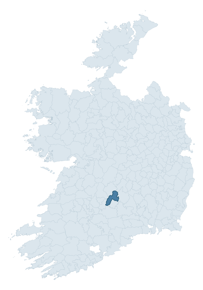
Where this barony sits in the Republic of Ireland
Geology and preservation
Bedrock geology shapes the landscape long before any settlement begins — controlling soil drainage, agricultural potential, the survival of upstanding monuments, and the preservation of buried archaeology. The figures below come from the Geological Survey Ireland 1:100,000 bedrock map.
The bedrock underlying Kilnamanagh Upper is predominantly greywack, siltstone and grit (64% of the barony by area), laid down during the Silurian period (64% by area, around 444 to 419 million years ago). A substantial secondary geology of sandstone, conglomerate (20%) adds further variety to the underlying landscape. The single largest mapped unit is the Hollyford Formation (64% of the barony's bedrock).
Rock type composition
Largest mapped unit: Hollyford Formation (64% of the barony)
Placename evidence
Logainm records 23 heritage-diagnostic placenames for Kilnamanagh Upper, drawn from townland and civil-parish names across the barony. The dominant stratum is Early Christian ecclesiastical — cill-, teampall-, and domhnach-prefixed names that record the dense network of early church foundations established between the fifth and tenth centuries. The leading diagnostic roots are cill- (9 — church), lios- (3 — ringfort or enclosure), and ráth- (2 — earthen ringfort). This is below the ROI average of 30.7 heritage placenames per barony, suggesting either lighter survey coverage or a townland-naming tradition that draws more on generic landscape vocabulary. The presence of multiple heritage strata side by side indicates layered occupation of the landscape across successive prehistoric and historic periods. Logainm records 225 placenames for Kilnamanagh Upper (predominantly townland names). Of these, 23 (10%) carry one of the diagnostic Gaelic roots tracked above; the remainder draw on more generic landscape vocabulary that does not encode a heritage period.
Pre-Christian / Early Medieval Defensive
| Root | Count | Meaning |
|---|---|---|
| lios- | 3 | ringfort or enclosure |
| ráth- | 2 | earthen ringfort |
| dún- | 2 | hilltop or promontory fort |
| caiseal- | 1 | stone ringfort |
Early Christian Ecclesiastical
| Root | Count | Meaning |
|---|---|---|
| cill- | 9 | church (early) |
| teampall- | 2 | church (later medieval) |
| gráinseach- | 2 | monastic farm / grange |
| cillín- | 1 | unconsecrated burial ground |
Burial, Ritual, and Norse-Contact
| Root | Count | Meaning |
|---|---|---|
| tuaim- | 1 | burial mound |
Other baronies in Tipperary
- Iffa And Offa West
- Ikerrin
- Ormond Upper
- Owney And Arra
- Upperthird
- Iffa And Offa East
- Middlethird
- Clanwilliam — Limerick
- Islands — Clare
- Carbery East (west Division) — Cork
See all 280 baronies in the Republic of Ireland Heritage Tool.

Explore further
Grounding History: 10 Maps of Northern Ireland’s Past
If you’re interested in Irish heritage more widely, the companion report for Northern Ireland brings together the analysis of all 462 NI wards into one place through 10 high-quality maps — covering monument density, archaeological periods, placename heritage, terrain, wetland, and the historic landscape at first survey. Take a look.
About this profile
Click any section below to expand.
What is a barony?
A barony is a historic administrative unit in Ireland, broadly equivalent to an English hundred. The 280 baronies used here are from the OSi 2019 National Statutory Boundaries (generalised 20m), covering the 26 counties of the Republic of Ireland. Baronies derive from the Norman period, were formalised in the 17th century, and have not been redrawn for statistical purposes. They vary enormously in area, from compact urban baronies in Dublin to vast upland baronies in Connacht, and should not be compared by raw site count without accounting for area differences.
What counts as a site?
This profile combines three distinct heritage registers, each with its own definition of what constitutes a recordable site:
- Archaeological sites (NMS). The National Monuments Service Sites and Monuments Record (SMR) catalogues every known archaeological monument or site of archaeological interest in the Republic, from prehistoric burial mounds and ringforts to medieval churches and post-medieval defensive works. Inclusion does not require legal protection — only that the site has been identified, surveyed, and assessed as having archaeological value. A separate subset of these sites lies within a recorded protection zone, which gives them statutory protection under the National Monuments Acts.
- Listed buildings (NIAH). The National Inventory of Architectural Heritage records buildings of architectural, historical, archaeological, artistic, cultural, scientific, social, or technical interest. Each surveyed structure is appraised on a five-tier scale: International, National, Regional, Local, and Record-Only. The NIAH appraisal is informational rather than strictly statutory, but it underpins local-authority Record of Protected Structures (RPS) listings.
- Heritage placenames (Logainm). Logainm is the authoritative database of Irish placenames maintained by the Placenames Branch. This profile applies a heritage-diagnostic classifier to the Irish-language form of each townland name, flagging roots that signal defensive sites (ráth-, lios-, dún-, caiseal-, cathair-), ecclesiastical foundations (cill-, teampall-, domhnach-, mainistir-), prehistoric burial-ritual features (tuaim-, carn-, leaba-), or Norse-contact settlement (gall-). Townlands without one of these diagnostic roots are not flagged here — they may still carry historical significance, but that significance is not encoded in the name itself.
Editorial principles
The narrative sections of this profile follow several explicit principles:
- Evidential. Every claim about this barony’s heritage character is anchored in the underlying register data. Where a site count, a placename count, or a percentile rank is cited, it is computed from the source datasets at export time, not estimated.
- Comparative. Counts and metrics are reported alongside their percentile rank against the other 279 ROI baronies. A barony with 50 ringforts in absolute terms could be unusually high or unusually low depending on its size and regional context; percentile ranking removes that ambiguity.
- Transparent on limits. Where a register has known coverage gaps, survey biases, or data-quality issues that affect this barony’s figures, the profile flags them rather than presenting the numbers as definitive.
- No interpretation beyond what the data supports. The narrative does not speculate about historical events, social dynamics, or cultural meaning beyond what the recorded heritage and placename evidence directly attests.
Data caveats and limits
- NMS Sites and Monuments Record is the product of survey campaigns conducted at different intensities across different counties and decades. Some baronies have been surveyed more thoroughly than others, and absolute counts should be read in that light. Sites destroyed by development before survey are typically not represented; sites in heavily forested or upland terrain are sometimes under-recorded.
- NIAH coverage is broadly complete for the Republic of Ireland but the survey was conducted on a rolling county-by-county basis, and the most recent appraisal date varies. Buildings demolished or substantially altered after their original survey may still appear in the register; conversely, recent buildings of merit may not yet have been appraised.
- Logainm classification applies a deliberately conservative pattern-matching approach to the Irish-language townland forms. The classifier prioritises true positives over recall: a townland may carry a heritage signal that the classifier doesn’t recognise, particularly where the diagnostic root has been heavily anglicised or where the townland name draws on a less common term. The 60,000+ townland records and ~9,800 classified placenames give a substantial signal at barony scale, but individual townland names should be checked against Logainm directly for definitive interpretation.
- Period attribution. The chronological distribution reflects only those NMS sites that carry a recognised period attribution in the source data. Sites listed as “Unknown” period are excluded from the dated subset.
- Boundary changes. Some baronies have undergone minor boundary adjustments since their 19th-century definition; the OSi 2019 generalised boundaries used here are the current statutory definition and may differ slightly from historical maps in border areas.
- Bedrock geology is mapped at 1:100,000 scale, which means local variation within a barony — small pockets of different rock type, mineral veins, alluvium overlying bedrock — is generalised. The dominant-system and rocktype figures are area-weighted, so a barony reading “70% Carboniferous limestone” may still contain small but archaeologically important pockets of older or younger rock. Around 3% of GSI polygons do not match the lexicon and contribute no rocktype or system attribution.
Data sources
- National Monuments Service — Sites and Monuments Record (SMR) https://data.gov.ie/dataset/national-monuments-service-archaeological-survey-of-ireland
- National Inventory of Architectural Heritage (NIAH) https://data.gov.ie/dataset/national-inventory-of-architectural-heritage-niah-national-dataset
- Logainm — Placenames Database of Ireland https://www.logainm.ie/
- Ordnance Survey Ireland — National Statutory Barony Boundaries 2019 https://data-osi.opendata.arcgis.com/
- EURODEM — European Digital Elevation Model https://www.mapsforeurope.org/datasets/euro-dem
- ESA WorldCover https://esa-worldcover.org/en
- Geological Survey Ireland — 1:100,000 Bedrock Geology https://www.gsi.ie/en-ie/data-and-maps/Pages/Bedrock.aspx
Explore more: Search any of the 280 ROI baronies, browse by historical province, or read the methodology and data sources for the full Republic of Ireland Heritage Tool.