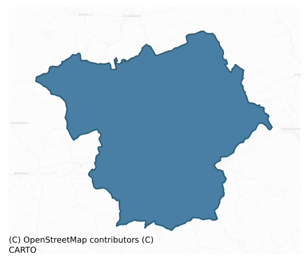
Kinalmeaky is a barony of County Cork, in the historical province of Munster (Irish: Cineál mBéice), covering 147 km² of land. The barony records 355 NMS archaeological sites and 256 NIAH listed buildings, placing it at around the 68th percentile among 280 ROI baronies for sites per km². This means it is in the top third of all baronies for sites per km². Dated archaeological evidence runs from the Neolithic through to the Modern, spanning 8 of 9 archaeological periods, placing the barony in the 62nd percentile among 280 ROI baronies for chronological depth. This means it is in the upper half of all baronies for chronological depth. The largest dated subset of recorded sites dates to the Early Medieval. Logainm flags 24 placenames in the barony as carrying a recognised heritage root; the largest share — around 62% — are names associated with early Christian church and monastic foundations.
Heritage at a glance
Percentile rankings throughout this profile compare each barony only against the other 279 Republic of Ireland baronies.
The recorded heritage of Kinalmeaky
The National Monuments Service Sites and Monuments Record (SMR) is the statutory inventory of archaeological sites for the Republic of Ireland, maintained by the Department of Tourism, Culture, Arts, Gaeltacht, Sport and Media. Sites recorded here include earthworks, ringforts, megalithic tombs, ecclesiastical remains, and post-medieval features; not every record is legally protected, but each is registered as a monument of archaeological interest.
The National Monuments Service records 355 archaeological sites in Kinalmeaky, putting it at the 68th percentile among 280 ROI baronies for sites per km². This means it is in the top third of all baronies for sites per km². Protection coverage is near-universal — 341 sites (96%) fall within a recorded monument protection zone, indicating an extensively surveyed landscape. The dominant category is defensive sites — ringforts, enclosures, hillforts, and stone forts (155 sites, 44% of the record). Ringfort – rath is the most prevalent type, making up 25% of the barony's recorded sites (88 records) — well above the ROI average of 20% across all baronies where this type occurs. Ringfort – rath is an earthen ringfort enclosed by a bank and external ditch — the most common Early Medieval farmstead, broadly dated 500–1000 AD. Other significant types include Fulacht fia (49) and Souterrain (40). Fulacht fia is a horseshoe-shaped Bronze Age burnt mound built around a sunken trough beside a water source, traditionally interpreted as a cooking site; Souterrain is an underground stone-built passage and chamber, generally Early Medieval and often associated with ringforts as a defensive or storage feature. Across the barony's 147 km², this gives a recorded density of 2.41 sites per km².
Most common monument types
Hover or tap a monument type to see its definition.
| Type | Count |
|---|---|
| Ringfort – rath an earthen ringfort enclosed by a bank and external ditch — the most common Early Medieval farmstead, broadly dated 500–1000 AD | 88 |
| Fulacht fia a horseshoe-shaped Bronze Age burnt mound built around a sunken trough beside a water source, traditionally interpreted as a cooking site | 49 |
| Souterrain an underground stone-built passage and chamber, generally Early Medieval and often associated with ringforts as a defensive or storage feature | 40 |
| Standing stone a deliberately set upright stone, used variously as a Bronze/Iron Age burial marker, route marker or commemorative monument | 23 |
| Church a building used for public Christian worship, of any date from c. 500 AD onwards | 15 |
| Enclosure a banked or ditched feature of uncertain type, used as a catch-all where the original function cannot be determined from surface evidence | 12 |
| Burial ground an area set apart for burial that is not associated with a church, in use from the medieval period onwards | 11 |
Chronological distribution
The dated archaeological record for Kinalmeaky spans from the Neolithic through to the Modern, with activity attested across 8 of 9 archaeological periods. Every period from earliest to latest is represented in the record — an unbroken sequence of dated activity across the full chronological span. Activity concentrates most heavily in the Early Medieval (123 sites, 45% of dated material), with the Middle Late Bronze Age forming a secondary peak (52 sites, 19%). A further 81 recorded sites (23% of the overall NMS register for the barony) carry no period attribution — appearing as 'Unknown' in the bar chart below. This typically reflects either records that pre-date the standardised period vocabulary or sites awaiting specialist dating review, rather than a genuine absence of chronological evidence.
Sample of recorded monuments
Show 25 sample monuments (of 355 total)
A representative sample of 25 recorded monuments drawn from the barony’s 355 total NMS entries. Sites within a recorded monument protection zone and rarer site types are prioritised so the list shows a meaningful cross-section rather than only the most common type. Each entry shows the official Sites and Monuments Record reference number and the description published by the National Monuments Service.
Pit
Irregular pit locally known as "Sean-Mhulteann" (Ó Riordain 1931, 67). Now planted with conifers.
The above description is derived from the published 'Archaeological Inventory of County Cork. Volume 1: West Cork'…
Irregular pit locally known as "Sean-Mhulteann" (Ó Riordain 1931, 67). Now planted with conifers.
The above description is derived from the published 'Archaeological Inventory of County Cork. Volume 1: West Cork' (Dublin: Stationery Office, 1992). In certain instances the entries have been revised and updated in the light of recent research.
Date of upload/revision: 14 January 2009
Ogham stone
Found in a ringfort (CO084-090001-) and thought to have come from the souterrain (CO084-090002-) discovered later. Now on permanent display in the Stone Corridor, University College Cork (See CO074-148—-). According…
Found in a ringfort (CO084-090001-) and thought to have come from the souterrain (CO084-090002-) discovered later. Now on permanent display in the Stone Corridor, University College Cork (See CO074-148—-). According to Macalister (1945, 83, no. 81), it measures '5'9" x 1'7" x 0'7"' and reads: C[A]SSITT[A]S MAQI MUCOI CALLITI. McManus (2004, 15, no. 4) is generally in agreement but notes that the first name could end in -AS or -OS. (Power et al. 1992, no. 1037)
Compiled by: Nora White
Date of upload: 3 April 2016
House – fortified house
On gentle S-facing slope in marshy, rough grazing with some rock outcropping. Sod-covered foundations of L-shaped house (19m E-W; 20m N-S) with circular tower (int. diam. 2.7m) at NW corner; part of wall-facings visible…
On gentle S-facing slope in marshy, rough grazing with some rock outcropping. Sod-covered foundations of L-shaped house (19m E-W; 20m N-S) with circular tower (int. diam. 2.7m) at NW corner; part of wall-facings visible to E (wall thickness 1.2m). Two circular two-storey towers lie 23.3m to W, 23.5m apart, linked by much repaired wall (max. H c. 3m) on same axis as W wall of house. Tower to N (int. diam. 2.2m; wall thickness 0.9m) entered by linteled door to SE; tower to S (int. diam. 2.3m; wall thickness 0.75m) entered by similar door at NE corner, at 1st floor level gun loop (narrow vertical slit with D-shaped terminals) covers outside of wall running N, lintelled window faces W. Running N from northern tower and E from southern tower are walls of large rectangular enclosure of c. 19th century date. Remains of Mossgrove house built by Baldwin family in 17th century, they later moved to Mount Plesant House (OS Name Books; Lewis 1837 Vol 2, 602; Ó Ríordáin 1931, 62; Healy 1988, 279).
The above description is derived from the published 'Archaeological Inventory of County Cork. Volume 1: West Cork' (Dublin: Stationery Office, 1992). In certain instances the entries have been revised and updated in the light of recent research.
Date of upload/revision: 14 January 2009
Megalithic structure
In tillage. Described in O.S. Name Book for 1st ed. map as 'a very large irregular shaped stone erected upon 5 lesser ones'. No visible surface trace.
The above description is derived from the published…
In tillage. Described in O.S. Name Book for 1st ed. map as 'a very large irregular shaped stone erected upon 5 lesser ones'. No visible surface trace.
The above description is derived from the published 'Archaeological Inventory of County Cork. Volume 1: West Cork' (Dublin: Stationery Office, 1992). In certain instances the entries have been revised and updated in the light of recent research.
Date of upload/revision: 14 January 2009
Kiln – lime
Roadside, built against N-facing slope; partially collapsed; front elevation (H 4.85m); with arched recess (H 2.4m; Wth 2.1m). Funnel infilled.
The above description is derived from the published 'Archaeological…
Roadside, built against N-facing slope; partially collapsed; front elevation (H 4.85m); with arched recess (H 2.4m; Wth 2.1m). Funnel infilled.
The above description is derived from the published 'Archaeological Inventory of County Cork. Volume 1: West Cork' (Dublin: Stationery Office, 1992). In certain instances the entries have been revised and updated in the light of recent research.
Date of upload/revision: 14 January 2009
Stone row
In level pasture on E side of broad valley, to N of Castlenalacht lake. Row of four stones, aligned NE-SW, and 13.4m in overall length. Long axes of three stones do not conform to main axis of row. NE stone, the…
In level pasture on E side of broad valley, to N of Castlenalacht lake. Row of four stones, aligned NE-SW, and 13.4m in overall length. Long axes of three stones do not conform to main axis of row. NE stone, the tallest, is1.7m L, 0.8m T and 3.4m H. Next stone, 2.55m to SW, is 1.25m L, 0.9m T and 2.5m H. Third stone, 2.6m further to SW, is 1.25m L, 0.4m T and 1.9m H. SW stone, 2.6m from the last, is 1.45m L, 0.4m T and 1.9m H. (Ó Nualláin 1988, 235, no. 36).
The above description is derived from the published 'Archaeological Inventory of County Cork. Volume 1: West Cork' (Dublin: Stationery Office, 1992). In certain instances the entries have been revised and updated in the light of recent research.
Date of upload/revision: 14 January 2009
Mound
A subrectangular raised area (18.8m E-W; 18.6m N-S) defined by scarp (H 0.55m); wide shallow fosse to E and W (D 0.6m). Stones partially visible at NE corner. A castle (CO096-065001-) of which there are no visible…
A subrectangular raised area (18.8m E-W; 18.6m N-S) defined by scarp (H 0.55m); wide shallow fosse to E and W (D 0.6m). Stones partially visible at NE corner. A castle (CO096-065001-) of which there are no visible remains stood on this mound.
The above description is derived from the published 'Archaeological Inventory of County Cork. Volume 1: West Cork' (Dublin: Stationery Office, 1992). In certain instances the entries have been revised and updated in the light of recent research.
Date of upload/revision: 14 January 2009
Mass-rock
On W side of laneway running S towards a ford. Irregularly shaped sandstone block (L c.1m; Wth 0.55m; H 0.52m); known locally as "mass rock". (CMSS).
The above description is derived from the published…
On W side of laneway running S towards a ford. Irregularly shaped sandstone block (L c.1m; Wth 0.55m; H 0.52m); known locally as "mass rock". (CMSS).
The above description is derived from the published 'Archaeological Inventory of County Cork. Volume 1: West Cork' (Dublin: Stationery Office, 1992). In certain instances the entries have been revised and updated in the light of recent research.
Date of upload/revision: 14 January 2009
Bullaun stone
On S side of holy well (CO109-01501-). Subrectangular stone (H 0.15m; 0.86m x 0.57m). Two circular hollows (diam. 0.18m; D 0.06m: diam 0.23m; D 0.1m) at N end of upper surface. Local tradition that these were the marks…
On S side of holy well (CO109-01501-). Subrectangular stone (H 0.15m; 0.86m x 0.57m). Two circular hollows (diam. 0.18m; D 0.06m: diam 0.23m; D 0.1m) at N end of upper surface. Local tradition that these were the marks of a fugitive's knees who knelt at the well for a drink (Ó Riordáin 1932, 65).
The above description is derived from the published 'Archaeological Inventory of County Cork. Volume 1: West Cork' (Dublin: Stationery Office, 1992). In certain instances the entries have been revised and updated in the light of recent research.
Date of upload/revision: 14 January 2009
Ecclesiastical enclosure
In pasture, on gentle SW-facing slope. Roughly circular area (85m E-W; 80m N-S) enclosed by earthen bank (H 1.9m) SSE->E; scarp to SE. Bankstone-faced to NE; rubble dumped on scarp to SE; farmyard abuts line of…
In pasture, on gentle SW-facing slope. Roughly circular area (85m E-W; 80m N-S) enclosed by earthen bank (H 1.9m) SSE->E; scarp to SE. Bankstone-faced to NE; rubble dumped on scarp to SE; farmyard abuts line of enclosure to ESE where bank levelled. Kilcolman church (site of) (CO109-033003-) in SE quadrant of interior. Listed as early ecclesiastical enclosure (Hurley 1980, 60). Holy well (CO109-033001-) to SW, on opposite side of road.
The above description is derived from the published 'Archaeological Inventory of County Cork. Volume 1: West Cork' (Dublin: Stationery Office, 1992). In certain instances the entries have been revised and updated in the light of recent research.
Date of upload/revision: 14 January 2009
Standing stone (present location)
Stone originally located within trivallate ringfort (CO109-06101-); now standing in grounds of Cashelmore House. Sub-rectangular quartz stone (H 1.12m; 0.85m x 0.47m). (Ó Ríordáin 1932, 1).
The above description is…
Stone originally located within trivallate ringfort (CO109-06101-); now standing in grounds of Cashelmore House. Sub-rectangular quartz stone (H 1.12m; 0.85m x 0.47m). (Ó Ríordáin 1932, 1).
The above description is derived from the published 'Archaeological Inventory of County Cork. Volume 1: West Cork' (Dublin: Stationery Office, 1992). In certain instances the entries have been revised and updated in the light of recent research.
Date of upload/revision: 14 January 2009
Pit-burial
In flat tillage, c. 100m S of Bandon river. Pit (D 0.15m; Wth 0.2m), covered with slab (L 0.6m), contained small quantities of cremated bone mixed with soil. Adjacent standing stone (CO110-005—). (Shee-Twohig and…
In flat tillage, c. 100m S of Bandon river. Pit (D 0.15m; Wth 0.2m), covered with slab (L 0.6m), contained small quantities of cremated bone mixed with soil. Adjacent standing stone (CO110-005—). (Shee-Twohig and Doody 1989,52-55).
The above description is derived from the published 'Archaeological Inventory of County Cork. Volume 1: West Cork' (Dublin: Stationery Office, 1992). In certain instances the entries have been revised and updated in the light of recent research.
Date of upload/revision: 14 January 2009
Castle – tower house
Poorly preserved remains of rectangular tower which was incorporated into Castle Bernard House (now a ruin). Entered at ground level by door in N wall with pointed arch, now blocked. Wicker-centered vault (axis N-S)…
Poorly preserved remains of rectangular tower which was incorporated into Castle Bernard House (now a ruin). Entered at ground level by door in N wall with pointed arch, now blocked. Wicker-centered vault (axis N-S) over ground floor. Above this level tower heavily modified as part of later house. Castle Mahon was chief residence of Kinalmeaky branch of O Mahony clan; burnt by O Mahonys in 1580s after confiscation by the Crown (Ó Murchadha 1985, 238-9). House burnt c. 1921 and now a roofless ruin. Built c. 1798: 2-storey, 9-bay front with deep central bow to rear, battlements and turrets aded c. 1815; tower stood to W of house to which it was linked by corridor (Bence-Jones 1978, 62).
The above description is derived from the published 'Archaeological Inventory of County Cork. Volume 1: West Cork' (Dublin: Stationery Office, 1992). In certain instances the entries have been revised and updated in the light of recent research.
Date of upload/revision: 14 January 2009
This monument is subject to a preservation order made under the National Monuments Acts 1930 to 2014 (PO no. 5/2002).
School
Roofless single-storey structure, gable ended, pointed door and window opes. Single classroom on N side. Two-roomed residential quarters (7m N-S; 5.75m E-W) adjoining to S, with fireplaces and brick-lined oven (H 0.4m;…
Roofless single-storey structure, gable ended, pointed door and window opes. Single classroom on N side. Two-roomed residential quarters (7m N-S; 5.75m E-W) adjoining to S, with fireplaces and brick-lined oven (H 0.4m; diam. 0.7m).
The above description is derived from the published 'Archaeological Inventory of County Cork. Volume 1: West Cork' (Dublin: Stationery Office, 1992). In certain instances the entries have been revised and updated in the light of recent research.
Date of upload/revision: 14 January 2009
Historic town
On N and S banks of Bandon river, walled town created in early decades of 17th century under the patronage of Richard Boyle, Earl of Cork. The town today is largely of 19th-century character; apart from Christ Church…
On N and S banks of Bandon river, walled town created in early decades of 17th century under the patronage of Richard Boyle, Earl of Cork. The town today is largely of 19th-century character; apart from Christ Church (3344) no buildings of 17th century survive; however, sections of town wall can still be traced. No remains of wall on N side of river apart from short section to rear of house on E side of North Main Street and possibly the core of the N boundary wall to graveyard at Christ Church. South of river are more extensive remains: two runs of E wall (for 22m and 11.5m) between St. Patrick's Hill and Casement Road; most of S wall replaced by later wall on same line but probable original section (L c. 20m) on steps up to Catholic Church from Market Street; another stretch (L 24.3m) along E side of Church Street; E, S and W boundary wall of St Peter's Church (3351) on line of wall and batter at base of S wall may be original feature; best preserved sections are two lengths of W wall as it approaches river to N: running due S from river bank 18m stretch (wall thickness 2.75m) to 5.5m gap, then 70m stretch (wall thickness 3.5m) running in SW direction; the wall itself is low (H c. 1m) with narrow walls (H c. 1.5m; thickness c. 0.45m) along inner and outer edge forming narrow walkway. No defensive features are preserved and no trace of town's gates (CO110-019002-). (Connolly 1985, 55-60; MacCarthy-Morrogh 1986, 55-62; O'Flanagan 1988, 1-16)
see Excavations 2000, no. 11…
Barracks
On Dunmanway road in Bandon (CO110-019001-). Curved NE corner (H 3.4m) of barrack enclosure; 7 rectangular splayed gun loops (ext. Wth 0.12m; H0.45m) at 2.4m above ground level. Ordnance stone at ground level.
The…
On Dunmanway road in Bandon (CO110-019001-). Curved NE corner (H 3.4m) of barrack enclosure; 7 rectangular splayed gun loops (ext. Wth 0.12m; H0.45m) at 2.4m above ground level. Ordnance stone at ground level.
The above description is derived from the published 'Archaeological Inventory of County Cork. Volume 1: West Cork' (Dublin: Stationery Office, 1992). In certain instances the entries have been revised and updated in the light of recent research.
Date of upload/revision: 14 January 2009
Town defences
On N and S banks of Bandon river, walled town created in early decades of 17th century under the patronage of Richard Boyle, Earl of Cork. The town today is largely of 19th-century character; apart from Christ Church…
On N and S banks of Bandon river, walled town created in early decades of 17th century under the patronage of Richard Boyle, Earl of Cork. The town today is largely of 19th-century character; apart from Christ Church (3344) no buildings of 17th century survive; however, sections of town wall can still be traced. No remains of wall on N side of river apart from short section to rear of house on E side of North Main Street and possibly the core of the N boundary wall to graveyard at Christ Church. South of river are more extensive remains: two runs of E wall (for 22m and 11.5m) between St. Patrick's Hill and Casement Road; most of S wall replaced by later wall on same line but probable original section (L c. 20m) on steps up to Catholic Church from Market Street; another stretch (L 24.3m) along E side of Church Street; E, S and W boundary wall of St Peter's Church (3351) on line of wall and batter at base of S wall may be original feature; best preserved sections are two lengths of W wall as it approaches river to N: running due S from river bank 18m stretch (wall thickness 2.75m) to 5.5m gap, then 70m stretch (wall thickness 3.5m) running in SW direction; the wall itself is low (H c. 1m) with narrow walls (H c. 1.5m; thickness c. 0.45m) along inner and outer edge forming narrow walkway. No defensive features are preserved and no trace of town's gates (CO110-019002-). (Connolly 1985, 55-60; MacCarthy-Morrogh 1986, 55-62; O'Flanagan 1988, 1-16)
see Excavations 2000, no. 11…
Earthwork
This record refers to a 'Danish entrenchment or fort' recorded by O Ríordáin (1932, 18-19) and Smith (1815, 237) as being the location on which the Church of Ireland Church (CO110-019008-) was erected. This possible…
This record refers to a 'Danish entrenchment or fort' recorded by O Ríordáin (1932, 18-19) and Smith (1815, 237) as being the location on which the Church of Ireland Church (CO110-019008-) was erected. This possible earthwork was referred to in the 'Archaeological Inventory of County Cork – vol. 1 West Cork' (1992, 369) under the entry (no. 3344) for the Church of Ireland church (CO110-019008-).
The above description is derived from the published 'Archaeological Inventory of County Cork. Volume 1: West Cork' (Dublin: Stationery Office, 1992). In certain instances the entries have been revised and updated in the light of recent research.
Date of upload/revision: 14 January 2009
Shambles
Meat shambles built on E-facing slope adjacent to Bandon Fair Green. Sixteen-sided stone walled enclosure (diam. c. 45m; H c.6m) with corner buttresses built 1817; eastern bays have oeil-de-boeuf opes. Arched doorway in…
Meat shambles built on E-facing slope adjacent to Bandon Fair Green. Sixteen-sided stone walled enclosure (diam. c. 45m; H c.6m) with corner buttresses built 1817; eastern bays have oeil-de-boeuf opes. Arched doorway in NW wall. Two-storey residential house fills bay to SW with inscribed stone (illegible) over central arched passage into interior, now blocked. Along internal S wall of enclosure are remains of lean-to stalls, on W side are modern dwellings/buildings. In centre, an 8-sided roofless slaughter house (diam. c. 20m; H 3.8m). The shambles is now in use as flats and retail units following renovations, c. 2000.
The above description is derived from the published 'Archaeological Inventory of County Cork. Volume 1: West Cork' (Dublin: Stationery Office, 1992). In certain instances the entries have been revised and updated in the light of recent research.
Updated by: Paul Walsh
Revised date of upload: 17 March 2015
Architectural fragment
Numerous fragments of cut stone reused in door and window opes of farm building; according to owner, stones removed from church (CO110-023—-) in early 20th century.
The above description is derived from the…
Numerous fragments of cut stone reused in door and window opes of farm building; according to owner, stones removed from church (CO110-023—-) in early 20th century.
The above description is derived from the published 'Archaeological Inventory of County Cork. Volume 1: West Cork' (Dublin: Stationery Office, 1992). In certain instances the entries have been revised and updated in the light of recent research.
Date of upload/revision: 14 January 2009
Icehouse
In woodland, built into N-facing slope in demesne of Castle Bernard house. Circular in plan (H 3.4m; int. diam. c. 6m; wall thickness 0.85m); sunken interior (D 3m). Domed roof crowned externally with conical slate…
In woodland, built into N-facing slope in demesne of Castle Bernard house. Circular in plan (H 3.4m; int. diam. c. 6m; wall thickness 0.85m); sunken interior (D 3m). Domed roof crowned externally with conical slate roof. Remains of porch entrance to SE.
The above description is derived from the published 'Archaeological Inventory of County Cork. Volume 1: West Cork' (Dublin: Stationery Office, 1992). In certain instances the entries have been revised and updated in the light of recent research.
Date of upload/revision: 14 January 2009
Cross – Market cross
The Archaeological Survey of Ireland (ASI) is in the process of providing information on all monuments on The Historic Environment Viewer (HEV). Currently the information for this record has not been uploaded. To…
The Archaeological Survey of Ireland (ASI) is in the process of providing information on all monuments on The Historic Environment Viewer (HEV). Currently the information for this record has not been uploaded. To access available information for research purposes please make an appointment in advance with the Archive Unit (open Fridays 10.00 am – 5.00 pm), Department of Culture, Heritage and the Gaeltacht, The Custom House, Dublin 1 D01W6XO or email nmarchive@chg.gov.ie.
Prison
The Archaeological Survey of Ireland (ASI) is in the process of providing information on all monuments on The Historic Environment Viewer (HEV). Currently the information for this record has not been uploaded. To…
The Archaeological Survey of Ireland (ASI) is in the process of providing information on all monuments on The Historic Environment Viewer (HEV). Currently the information for this record has not been uploaded. To access available information for research purposes please make an appointment in advance with the Archive Unit (open Fridays 10.00 am – 5.00 pm), Department of Culture, Heritage and the Gaeltacht, The Custom House, Dublin 1 D01W6XO or email nmarchive@chg.gov.ie.
Hut site
The Archaeological Survey of Ireland (ASI) is in the process of providing information on all monuments on The Historic Environment Viewer (HEV). Currently the information for this record has not been uploaded. To…
The Archaeological Survey of Ireland (ASI) is in the process of providing information on all monuments on The Historic Environment Viewer (HEV). Currently the information for this record has not been uploaded. To access available information for research purposes please make an appointment in advance with the Archive Unit (open Fridays 10.00 am – 5.00 pm), Department of Culture, Heritage and the Gaeltacht, The Custom House, Dublin 1 D01W6XO or email nmarchive@chg.gov.ie.
Ringfort – rath
Originally circular area (diam. c. 45m); earthen bank survives to W, incorporated into field fence system, with silted-up external fosse.
The above description is derived from the published 'Archaeological Inventory…
Originally circular area (diam. c. 45m); earthen bank survives to W, incorporated into field fence system, with silted-up external fosse.
The above description is derived from the published 'Archaeological Inventory of County Cork. Volume 1: West Cork' (Dublin: Stationery Office, 1992). In certain instances the entries have been revised and updated in the light of recent research.
Date of upload/revision: 14 January 2009
Listed buildings
The National Inventory of Architectural Heritage (NIAH) is a state survey appraising buildings of architectural, historical, archaeological, artistic, cultural, scientific, social, or technical interest. Each surveyed structure receives a rating from International (the highest, for buildings of European importance) through National, Regional, Local, and Record-Only.
The NIAH records 256 listed buildings in Kinalmeaky, the 84th percentile across ROI baronies for listed-building density. The highest-graded structures include 2 of National significance. The Republic holds 937 National-graded buildings in total, so this barony accounts for around 0% of the national total. Construction dates concentrate most heavily in the Victorian (1830-1900) period. The most-recorded building type is house (139 examples, 54% of the listed stock).
Terrain and environment
Mean elevation across the barony is 104m — the 61st percentile among 280 ROI baronies for elevation. This means it is in the upper half of all baronies for elevation. Elevation matters for heritage because higher-altitude baronies typically favour defensive monuments — ringforts and hilltop forts placed on prominent ground — while lowland baronies are more likely to carry the dense settlement and church networks of intensive agricultural landscapes. A maximum elevation of 232m gives the barony meaningful vertical relief. Mean slope is 4.6° — the 70th percentile among 280 ROI baronies for slope. This means it is in the top third of all baronies for slope. Slope is a key control on both land use and archaeological preservation: steep ground resists ploughing and tends to preserve earthworks intact, while gentle slopes favour intensive cultivation that damages or destroys surface archaeology over time. The Topographic Wetness Index averages 10.2, the 26th percentile among 280 ROI baronies for wetness. This means it is in the bottom third of all baronies for wetness. Drainage matters for heritage because poorly-drained ground preserves organic archaeology (wooden trackways, leather, textiles, and on rare occasions human remains) far better than free-draining soil; well-drained ground favours arable use but destroys organic material rapidly. The land-cover mosaic combines improved grassland (77%), woodland (15%), and arable farmland (6%), giving a mixed agricultural and semi-natural landscape.
Terrain measurements
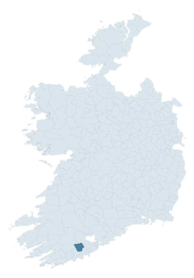
Where this barony sits in the Republic of Ireland
Geology and preservation
Bedrock geology shapes the landscape long before any settlement begins — controlling soil drainage, agricultural potential, the survival of upstanding monuments, and the preservation of buried archaeology. The figures below come from the Geological Survey Ireland 1:100,000 bedrock map.
The bedrock underlying Kinalmeaky is predominantly mudstone (64% of the barony by area), laid down during the Devonian period (61% by area, around 419 to 359 million years ago). Mudstone breaks down into heavy, often poorly-drained clay soils that historically limited intensive arable use. The lower density of ploughing tends to preserve subsurface archaeology better than in sandstone or limestone terrain, though waterlogging can be a factor for site survival. A substantial secondary geology of sandstone (30%) adds further variety to the underlying landscape. The single largest mapped unit is the Kinsale Formation (34% of the barony's bedrock).
Rock type composition
Largest mapped unit: Kinsale Formation (34% of the barony)
Placename evidence
Logainm records 24 heritage-diagnostic placenames for Kinalmeaky, drawn from townland and civil-parish names across the barony. The dominant stratum is Early Christian ecclesiastical — cill-, teampall-, and domhnach-prefixed names that record the dense network of early church foundations established between the fifth and tenth centuries. The leading diagnostic roots are cill- (14 — church), caiseal- (3 — stone ringfort), and lios- (2 — ringfort or enclosure). This is broadly in line with the ROI average of 30.7 heritage placenames per barony. The presence of multiple heritage strata side by side indicates layered occupation of the landscape across successive prehistoric and historic periods. Logainm records 81 placenames for Kinalmeaky (predominantly townland names). Of these, 24 (30%) carry one of the diagnostic Gaelic roots tracked above; the remainder draw on more generic landscape vocabulary that does not encode a heritage period.
Pre-Christian / Early Medieval Defensive
| Root | Count | Meaning |
|---|---|---|
| caiseal- | 3 | stone ringfort |
| lios- | 2 | ringfort or enclosure |
Early Christian Ecclesiastical
| Root | Count | Meaning |
|---|---|---|
| cill- | 14 | church (early) |
| teampall- | 1 | church (later medieval) |
Burial, Ritual, and Norse-Contact
| Root | Count | Meaning |
|---|---|---|
| leacht- | 2 | grave monument |
| gall- | 2 | foreigner — Norse settlement marker |
Other baronies in Cork
- Courceys
- Carbery West (east Division)
- Bear
- Barretts
- Kinsale
- Condons And Clangibbon
- Carbery East (west Division)
- Barrymore
- Magunihy — Kerry
- Decies Within Drum — Waterford
See all 280 baronies in the Republic of Ireland Heritage Tool.

Explore further
Grounding History: 10 Maps of Northern Ireland’s Past
If you’re interested in Irish heritage more widely, the companion report for Northern Ireland brings together the analysis of all 462 NI wards into one place through 10 high-quality maps — covering monument density, archaeological periods, placename heritage, terrain, wetland, and the historic landscape at first survey. Take a look.
About this profile
Click any section below to expand.
What is a barony?
A barony is a historic administrative unit in Ireland, broadly equivalent to an English hundred. The 280 baronies used here are from the OSi 2019 National Statutory Boundaries (generalised 20m), covering the 26 counties of the Republic of Ireland. Baronies derive from the Norman period, were formalised in the 17th century, and have not been redrawn for statistical purposes. They vary enormously in area, from compact urban baronies in Dublin to vast upland baronies in Connacht, and should not be compared by raw site count without accounting for area differences.
What counts as a site?
This profile combines three distinct heritage registers, each with its own definition of what constitutes a recordable site:
- Archaeological sites (NMS). The National Monuments Service Sites and Monuments Record (SMR) catalogues every known archaeological monument or site of archaeological interest in the Republic, from prehistoric burial mounds and ringforts to medieval churches and post-medieval defensive works. Inclusion does not require legal protection — only that the site has been identified, surveyed, and assessed as having archaeological value. A separate subset of these sites lies within a recorded protection zone, which gives them statutory protection under the National Monuments Acts.
- Listed buildings (NIAH). The National Inventory of Architectural Heritage records buildings of architectural, historical, archaeological, artistic, cultural, scientific, social, or technical interest. Each surveyed structure is appraised on a five-tier scale: International, National, Regional, Local, and Record-Only. The NIAH appraisal is informational rather than strictly statutory, but it underpins local-authority Record of Protected Structures (RPS) listings.
- Heritage placenames (Logainm). Logainm is the authoritative database of Irish placenames maintained by the Placenames Branch. This profile applies a heritage-diagnostic classifier to the Irish-language form of each townland name, flagging roots that signal defensive sites (ráth-, lios-, dún-, caiseal-, cathair-), ecclesiastical foundations (cill-, teampall-, domhnach-, mainistir-), prehistoric burial-ritual features (tuaim-, carn-, leaba-), or Norse-contact settlement (gall-). Townlands without one of these diagnostic roots are not flagged here — they may still carry historical significance, but that significance is not encoded in the name itself.
Editorial principles
The narrative sections of this profile follow several explicit principles:
- Evidential. Every claim about this barony’s heritage character is anchored in the underlying register data. Where a site count, a placename count, or a percentile rank is cited, it is computed from the source datasets at export time, not estimated.
- Comparative. Counts and metrics are reported alongside their percentile rank against the other 279 ROI baronies. A barony with 50 ringforts in absolute terms could be unusually high or unusually low depending on its size and regional context; percentile ranking removes that ambiguity.
- Transparent on limits. Where a register has known coverage gaps, survey biases, or data-quality issues that affect this barony’s figures, the profile flags them rather than presenting the numbers as definitive.
- No interpretation beyond what the data supports. The narrative does not speculate about historical events, social dynamics, or cultural meaning beyond what the recorded heritage and placename evidence directly attests.
Data caveats and limits
- NMS Sites and Monuments Record is the product of survey campaigns conducted at different intensities across different counties and decades. Some baronies have been surveyed more thoroughly than others, and absolute counts should be read in that light. Sites destroyed by development before survey are typically not represented; sites in heavily forested or upland terrain are sometimes under-recorded.
- NIAH coverage is broadly complete for the Republic of Ireland but the survey was conducted on a rolling county-by-county basis, and the most recent appraisal date varies. Buildings demolished or substantially altered after their original survey may still appear in the register; conversely, recent buildings of merit may not yet have been appraised.
- Logainm classification applies a deliberately conservative pattern-matching approach to the Irish-language townland forms. The classifier prioritises true positives over recall: a townland may carry a heritage signal that the classifier doesn’t recognise, particularly where the diagnostic root has been heavily anglicised or where the townland name draws on a less common term. The 60,000+ townland records and ~9,800 classified placenames give a substantial signal at barony scale, but individual townland names should be checked against Logainm directly for definitive interpretation.
- Period attribution. The chronological distribution reflects only those NMS sites that carry a recognised period attribution in the source data. Sites listed as “Unknown” period are excluded from the dated subset.
- Boundary changes. Some baronies have undergone minor boundary adjustments since their 19th-century definition; the OSi 2019 generalised boundaries used here are the current statutory definition and may differ slightly from historical maps in border areas.
- Bedrock geology is mapped at 1:100,000 scale, which means local variation within a barony — small pockets of different rock type, mineral veins, alluvium overlying bedrock — is generalised. The dominant-system and rocktype figures are area-weighted, so a barony reading “70% Carboniferous limestone” may still contain small but archaeologically important pockets of older or younger rock. Around 3% of GSI polygons do not match the lexicon and contribute no rocktype or system attribution.
Data sources
- National Monuments Service — Sites and Monuments Record (SMR) https://data.gov.ie/dataset/national-monuments-service-archaeological-survey-of-ireland
- National Inventory of Architectural Heritage (NIAH) https://data.gov.ie/dataset/national-inventory-of-architectural-heritage-niah-national-dataset
- Logainm — Placenames Database of Ireland https://www.logainm.ie/
- Ordnance Survey Ireland — National Statutory Barony Boundaries 2019 https://data-osi.opendata.arcgis.com/
- EURODEM — European Digital Elevation Model https://www.mapsforeurope.org/datasets/euro-dem
- ESA WorldCover https://esa-worldcover.org/en
- Geological Survey Ireland — 1:100,000 Bedrock Geology https://www.gsi.ie/en-ie/data-and-maps/Pages/Bedrock.aspx
Explore more: Search any of the 280 ROI baronies, browse by historical province, or read the methodology and data sources for the full Republic of Ireland Heritage Tool.