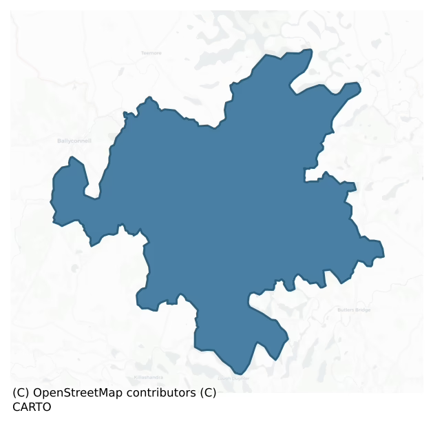
Loughtee Lower is a barony of County Cavan, in the historical province of Ulster (Irish: Lucht Tí Íochtarach), covering 120 km² of land. The barony records 154 NMS archaeological sites and 64 NIAH listed buildings, placing it at around the 23rd percentile among 280 ROI baronies for sites per km². This means it is in the bottom third of all baronies for sites per km². Dated archaeological evidence runs from the Mesolithic through to the Modern, spanning 9 of 9 archaeological periods, placing the barony in the 88th percentile among 280 ROI baronies for chronological depth. This means it is in the top fifth of all baronies for chronological depth. The largest dated subset of recorded sites dates to the Early Medieval. Logainm flags 23 placenames in the barony as carrying a recognised heritage root; the largest share — around 61% — are names associated with early Christian church and monastic foundations.

Heritage at a glance
Percentile rankings throughout this profile compare each barony only against the other 279 Republic of Ireland baronies.
The recorded heritage of Loughtee Lower
The National Monuments Service Sites and Monuments Record (SMR) is the statutory inventory of archaeological sites for the Republic of Ireland, maintained by the Department of Tourism, Culture, Arts, Gaeltacht, Sport and Media. Sites recorded here include earthworks, ringforts, megalithic tombs, ecclesiastical remains, and post-medieval features; not every record is legally protected, but each is registered as a monument of archaeological interest.
The National Monuments Service records 154 archaeological sites in Loughtee Lower, putting it at the 23rd percentile among 280 ROI baronies for sites per km². This means it is in the bottom third of all baronies for sites per km². Protection coverage is near-universal — 150 sites (97%) fall within a recorded monument protection zone, indicating an extensively surveyed landscape. The dominant category is defensive sites — ringforts, enclosures, hillforts, and stone forts (96 sites, 62% of the record). Crannog is the most prevalent type, making up 27% of the barony's recorded sites (42 records) — well above the ROI average of 5% across all baronies where this type occurs. Crannog is an artificial or partly artificial island built up on a lake or river bed, in use from the 6th to 17th centuries AD. Other significant types include Ringfort – rath (38) and Enclosure (9). Ringfort – rath is an earthen ringfort enclosed by a bank and external ditch — the most common Early Medieval farmstead, broadly dated 500–1000 AD; Enclosure is a banked or ditched feature of uncertain type, used as a catch-all where the original function cannot be determined from surface evidence. Across the barony's 120 km², this gives a recorded density of 1.29 sites per km².
Most common monument types
Hover or tap a monument type to see its definition.
| Type | Count |
|---|---|
| Crannog an artificial or partly artificial island built up on a lake or river bed, in use from the 6th to 17th centuries AD | 42 |
| Ringfort – rath an earthen ringfort enclosed by a bank and external ditch — the most common Early Medieval farmstead, broadly dated 500–1000 AD | 38 |
| Enclosure a banked or ditched feature of uncertain type, used as a catch-all where the original function cannot be determined from surface evidence | 9 |
| Fulacht fia a horseshoe-shaped Bronze Age burnt mound built around a sunken trough beside a water source, traditionally interpreted as a cooking site | 6 |
| Castle – unclassified a castle whose form cannot be precisely classified, dating somewhere between the late 12th and 16th centuries | 4 |
| Graveyard a burial area associated with a church, in use from the medieval period onwards | 4 |
| Bullaun stone a boulder or rock outcrop with hemispherical hollows ('bulláin'), commonly associated with ecclesiastical sites and holy wells | 3 |
Chronological distribution
The dated archaeological record for Loughtee Lower spans from the Mesolithic through to the Modern, with activity attested across 9 of 9 archaeological periods. This is the 88th percentile across ROI baronies for chronological depth — an above-average span. Every period from earliest to latest is represented in the record — an unbroken sequence of dated activity across the full chronological span. Activity concentrates most heavily in the Early Medieval (95 sites, 74% of dated material), with the Iron Age forming a secondary peak (15 sites, 12%). A further 26 recorded sites (17% of the overall NMS register for the barony) carry no period attribution — appearing as 'Unknown' in the bar chart below. This typically reflects either records that pre-date the standardised period vocabulary or sites awaiting specialist dating review, rather than a genuine absence of chronological evidence.
Sample of recorded monuments
Show 25 sample monuments (of 154 total)
A representative sample of 25 recorded monuments drawn from the barony’s 154 total NMS entries. Sites within a recorded monument protection zone and rarer site types are prioritised so the list shows a meaningful cross-section rather than only the most common type. Each entry shows the official Sites and Monuments Record reference number and the description published by the National Monuments Service.
Children's burial ground
Known as 'The Relic Field' (local information) this is traditionally believed to be the site of an ancient burial ground. A number of bones are said to have been found at the Rag River, 210m W of the reputed burial…
Known as 'The Relic Field' (local information) this is traditionally believed to be the site of an ancient burial ground. A number of bones are said to have been found at the Rag River, 210m W of the reputed burial ground. (ITA Survey 1941; Davies 1948, 94)
The above description is derived from the published 'Archaeological Inventory of County Cavan' (Dublin: Stationery Office, 1995). In certain instances the entries have been revised and updated in the light of recent research.
Date of upload/revision: 22 December 2008
Historic town
Davies (1948, 100) recorded that this site was constructed by Col. Wolseley in 1689. It is now largely occupied by a modern Church of Ireland chapel and graveyard. Bradley and Dunne (OPW 1989, 25-6) were of the opinion…
Davies (1948, 100) recorded that this site was constructed by Col. Wolseley in 1689. It is now largely occupied by a modern Church of Ireland chapel and graveyard. Bradley and Dunne (OPW 1989, 25-6) were of the opinion that 'it had been originally square with salient angled bastions at each corner'. Only the S side has survived. This comprises a substantial linear earthen rampart with external fosse and bastions at each end. Very slight traces of the NW bastion are also identifiable. The W and E ramparts and the NE bastion have been destroyed as a result of grave-digging. The graveyard wall and the modern roadway at its external foot are built on the site of the N rampart.
The above description is derived from the published 'Archaeological Inventory of County Cavan' (Dublin: Stationery Office, 1995). In certain instances the entries have been revised and updated in the light of recent research.
Date of upload/revision: 22 December 2008
Bastioned fort
Located on top of a hill at the W side of Belturbet town, with a SSW-NNE section of the River Erne and the motte (CV011-013002-) on Turbet Island in the valley c. 200m to the W. Davies (1948, 100) recorded that the fort…
Located on top of a hill at the W side of Belturbet town, with a SSW-NNE section of the River Erne and the motte (CV011-013002-) on Turbet Island in the valley c. 200m to the W. Davies (1948, 100) recorded that the fort at this location was constructed by Co. Wolseley in 1689. It is now largely occupied by a Church of Ireland church and graveyard. Bradley and Dunne (1989, 25-6) were of the opinion that ’it had been originally square with salient angled bastions at each corner’. Only the S side of the square enclosure (dims c. 50m N-S; c. 50m E-W) has survived. This comprises a substantial linear earthen rampart (Wth c. 8m; int. H c. 1m; ext. H c. 2m; L 30m) with an external berm and bastions at each end. The SE bastion (int. dims 12m E-W; 11.7m N-S) is grass-covered and largely free of burials. It is defined by earthen banks, best preserved at S (Wth of base 8m; Wth of top 2m; int. H 0.3m; ext. H 3.8m) where the outer fosse (Wth of base 1.5m; ext. D 1.7m) has been re-cut as a drain. About half of the SW bastion survives in its original condition, the rest having been leveled for burials. Very slight races of the NW bastion are also identifiable. The W and E rampart and the NE bastion have been destroyed as a result of grave-digging. The WNW-ESE graveyard wall at N and the modern roadway outside it are built roughly on the site of the N rampart, but the NE bastion extended under the road where there is a noticeable scarp on its E side.
The above description is derived…
Castle – motte and bailey
Strategically situated on Turbet Island, an important fording point on the River Erne, close to the boundary between the medieval kingdoms of East Breifne and Fermanagh. Constructed in 1210/11 by John Grey, King John's…
Strategically situated on Turbet Island, an important fording point on the River Erne, close to the boundary between the medieval kingdoms of East Breifne and Fermanagh. Constructed in 1210/11 by John Grey, King John's Justiciar. It was one of seven fortifications erected to isolate Ulster (in native Irish control) from Connacht. The campaign was short-lived as the Irish under Aedh O'Neill threw back the invaders. Davies (1947a, 82) believed that the Turbet Island motte and bailey had probably been abandoned by 1213. Motte comprises a high, steep-sided earthen mound, oval in plan (dims of base 47.5m WNW-ESE; 34m ENE-WSW) and basically conoid in profile (H 5.5m). At its highest point, at ESE, there are foundations of a small, subcircular, mortared stone structure (int. dims 2.05m x 2.9m). Davies (ibid., 81) interpreted this as the remains of a tower and speculated that it may be 16th-century in date. At the centre of the summit of the mound there is a deep, precipitous depression (Wth 9m; D 3.6m) aligned NNE-SSW which separates the highest ESE part of the motte from a crescent-shaped area (max. dims 8.4m NW-SE; 6.2m NE-SW) set at a lower level at WNW. A narrow fosse separates motte from bailey at SSW. Bailey is a raised subrectangular area (dims 38.8m NNE-SSW; 38m WNW-ESE) covering some 1278 square meters and enclosed by an earthen bank, traces of which are identifiable at SSW. Three low earthen mounds (dims 1.2m, 2m and 3.2m respectively) of unknown significance also occur…
Ford
Marked on all OS eds. An ancient fording point on the River Erne which forms the boundary between counties Cavan and Fermanagh. The name 'Bloody Pass' commemorates an engagement (see CV011-027—-) between a small party…
Marked on all OS eds. An ancient fording point on the River Erne which forms the boundary between counties Cavan and Fermanagh. The name 'Bloody Pass' commemorates an engagement (see CV011-027—-) between a small party of Enniskilleners and a detachment of King James' army, c. 31 July 1689, in which the Jacobite force was routed and many drowned while attempting the pass. The dead are said to have been buried in Galloon burial ground (CV011-016—-) c. 70m to SE. A modern bridge now spans the River Erne at this location. (Davies 1948, 95; Henry 1987, 25; O'Donovan 1995, no. 1888)
Revised by: Paul Walsh
Date of upload: 15 February 2018
Burial ground
Not marked on the 1st ed. OS 6-inch map (surveyed 1836) it is named on subsequent editions and revisions. On inspection in 1989 it was found to consist of an oval area (int. dims. 18m NW-SE; 8.4m NE-SW) enclosed by a…
Not marked on the 1st ed. OS 6-inch map (surveyed 1836) it is named on subsequent editions and revisions. On inspection in 1989 it was found to consist of an oval area (int. dims. 18m NW-SE; 8.4m NE-SW) enclosed by a narrow, shallow trench from SE-S-NW and elsewhere by a hedge. Apart from a number of small low stones protruding above the surface of the site, there were no visible remains. Variously known locally as 'Callaghan's Burial Ground' (SMR file) or as Gulldoon or Gullion Burial Ground (Gabhl Liuin – The Forked Inlet of Sorrow) or (Cuilleann – The Holly Bush) (http://www.drumlane.ie/index.php?page=the-bloody-pass) and is believed to have had a connection with the site of the Battle of Bloody Pass, c. 70m to NW (CV011-027—-). Davies (1948, 94) suggested that it may have been an early ecclesiastical site, the name of which has been forgotten. (O'Donovan 1995, no. 1732)
Revised by: Paul Walsh
Date of upload: 15 February 2018
Barrow – unclassified
Marked 'Fort' on OS 1836 and 1876eds. Sited on the S slope of a steep hill. Raised circular area (int. diam. 11.8m) enclosed by a low earthen bank with a wide, deep internal fosse. The internal area is greatly disturbed…
Marked 'Fort' on OS 1836 and 1876eds. Sited on the S slope of a steep hill. Raised circular area (int. diam. 11.8m) enclosed by a low earthen bank with a wide, deep internal fosse. The internal area is greatly disturbed by a modern field boundary running NNW-SSE which divides the site into two roughly equal portions. Original entrance not recognisable.
The above description is derived from the published 'Archaeological Inventory of County Cavan' (Dublin: Stationery Office, 1995). In certain instances the entries have been revised and updated in the light of recent research.
Date of upload/revision: 22 December 2008
Promontory fort – inland
Oval-shaped promontory (dims. 71.1m N-S; 62.5m E-W) surrounded by Dungummin Lough from SSW-N-SE and elsewhere enclosed by a wide, deep, partly waterlogged fosse and substantial earthen bank. Break in bank with…
Oval-shaped promontory (dims. 71.1m N-S; 62.5m E-W) surrounded by Dungummin Lough from SSW-N-SE and elsewhere enclosed by a wide, deep, partly waterlogged fosse and substantial earthen bank. Break in bank with accompanying causeway at SSW represents original entrance. Within the enclosed area at NE is a small approximately circular depression (D 0.88m; dims. 4.6m ENE-WSW; 4.2m NNW-SSE) which may be the remains of a hut site, although Davies (ITA Survey 1942) suggested that it might represent the remains of a limekiln.
The above description is derived from the published 'Archaeological Inventory of County Cavan' (Dublin: Stationery Office, 1995). In certain instances the entries have been revised and updated in the light of recent research.
Date of upload/revision: 22 December 2008
Megalithic tomb – court tomb
Situated just S of Dungummin Lough in pasture. The monument, a dual court tomb, is well preserved but overgrown. It is aligned roughly N-S and consists of two galleries, each divided by jambs into two chambers, set 1.1m…
Situated just S of Dungummin Lough in pasture. The monument, a dual court tomb, is well preserved but overgrown. It is aligned roughly N-S and consists of two galleries, each divided by jambs into two chambers, set 1.1m apart in a long oval mound. A single facade-stone is visible at the N end of the mound. A broad open court gives entry to the northern gallery. The front chamber here is 4m long and 1.5m to 1.7m wide. The rear chamber is 3.5m long and narrows towards the backstone. Only two stones, which also serve as entrance jambs, remain of the southern court. The front chamber here was about 4m long but its outer end is now missing. The rear chamber is 3.5m long and also narrows towards the back, (de Valera and Ó Nualláin 1972, 117-8, No. 17)
The above description is derived from the published 'Archaeological Inventory of County Cavan' (Dublin: Stationery Office, 1995). In certain instances the entries have been revised and updated in the light of recent research.
Date of upload/revision: 22 December 2008
See linked document with details from Ruaidhrí de Valera and Seán Ó Nualláin, Survey of the Megalithic Tombs of Ireland. Volume III. Counties Galway, Roscommon, Leitrim, Longford, Westmeath, Laoighis, Offaly, Kildare, Cavan. (Dublin: Stationery Office, 1972).
Road – unclassified togher
Marked 'Togher Br.' on OS 1836 and 1876 eds. A modern concrete bridge now spans 'TheRag River' at this location.
The above description is derived from the published 'Archaeological Inventory of County Cavan' (Dublin:…
Marked 'Togher Br.' on OS 1836 and 1876 eds. A modern concrete bridge now spans 'TheRag River' at this location.
The above description is derived from the published 'Archaeological Inventory of County Cavan' (Dublin: Stationery Office, 1995). In certain instances the entries have been revised and updated in the light of recent research.
Date of upload/revision: 22 December 2008
Field system
Situated on the S-facing slope of a broad N-S spur with the northern end of Derrybrick Lough visible to the SE and the northern end of Drumlane Lough visible to the SW, both of which are at the NW edge of the Lough…
Situated on the S-facing slope of a broad N-S spur with the northern end of Derrybrick Lough visible to the SE and the northern end of Drumlane Lough visible to the SW, both of which are at the NW edge of the Lough Oughter complex of lakes. The field system consists of rectangular fields (dims c. 30m x c. 30m) defined by broad earthen banks (Wth c. 3m; H c. 0.1-0.2m) or scarps and cover the area of the ecclesiastical enclosure and the ecclesiastical building (CV014-028005-) S of it, amounting to about 20 acres (c. 8 ha). A section of a road (L 30m; Wth 8.6m) defined by earthen banks (Wth 2.5-4.4m; H 0.1-0.2m) at N and S runs E-W through the fields and other roads could be present.
The above description is derived from the published 'Archaeological Inventory of County Cavan' (Dublin: Stationery Office, 1995). In certain instances the entries have been revised and updated in the light of recent research.
Date of revision: 27 July 2018
Religious house – Augustinian canons
Situated on the S-facing slope of a broad N-S spur with the northern end of Derrybrick Lough visible to the SE and the northern end of Drumlane Lough visible to the SW, both of which are at the NW edge of the Lough…
Situated on the S-facing slope of a broad N-S spur with the northern end of Derrybrick Lough visible to the SE and the northern end of Drumlane Lough visible to the SW, both of which are at the NW edge of the Lough Oughter complex of lakes. The original founder of the early monastery at Drumlane is not known with certainty. St Maodhóg or Mogue, also known as Aidan, who founded a monastery at Ferns (WX015-003002-) and is the patron saint of that diocese, is associated with Drumlane in a late, probably 16th century life, where he is said to have been educated in the company of St. Molaise of Devenish, in Lough Erne (Ó Riain 2011, 432-6). This elaboration is the result of Augustinian pretentions but it obscures the history of the early monastery, which St. Maodhóg is generally credited with founding. St Maodhóg’s relics were kept at Drumlane, and the house-shaped reliquary known as the Breac Maodhóg, dating from the 11th or 12the century and now in NMI, was kept there (Henry 1970, 117-19; Murray 2014). Erenachs, or descendants of the founder, are mentioned in 1025 (AU) and 1059 when Conaing Ua Faircheallaigh, erenach of Drumlane, was also described as the successor of Maodhóg in Leinster and Connaught (AFM).
The monastery was re-established as an Augustinian house in 1143-8, probably by St. Malachy or at his suggestion, and it became known as the priory of St Mary, which was under St Mary’s of Kells (ME017-044039-) although it was not listed as a possession of Kells at th…
Ecclesiastical enclosure
Situated on the S-facing slope of a broad N-S spur with the northern end of Derrybrick Lough visible to the SE and the northern end of Drumlane Lough visible to the SW, both of which are at the NW edge of the Lough…
Situated on the S-facing slope of a broad N-S spur with the northern end of Derrybrick Lough visible to the SE and the northern end of Drumlane Lough visible to the SW, both of which are at the NW edge of the Lough Oughter complex of lakes. The only evidence of the early church is the round tower (CV014-028002-) and the remnants of an ecclesiastical enclosure (diam. c. 220m N-S; c. 200m E-W) in the fields around the church (CV014-028003-) and graveyard (CV014-028009-). At N the enclosure is bounded by a grass-covered earthen bank (Wth 4m; int. H 0.2m; ext. H 0.6m) and outer fosse (Wth 4m; D 0.3m) that forms the N side of a triangular relict field situated between the car-park and a new graveyard. The boundary is continued by a low earthen bank in the field to the E, and it turns S where it meets the public road and runs past the E edge of the graveyard as a scarp. South of the graveyard it turns W and enters a confused area dominated by elements of a rectangular field system (CV014-028001-) that is probably late medieval or post-medieval in date. Further W the perimeter of the ecclesiastical enclosure turns N and can be traced as the vegetation mark of a fosse that almost connects with the N boundary of the triangular field.
Compiled by: Michael Moore
Date of upload: 27 July 2018
Ecclesiastical residence
Situated on a shelf towards the bottom of a N-facing slope, and c. 150m S of the Augustinian church (CV014-028003-) is a building described as an ‘Abbey (in Ruins)’ on the 1835 (L-shaped) and the 1908 (rectangular)…
Situated on a shelf towards the bottom of a N-facing slope, and c. 150m S of the Augustinian church (CV014-028003-) is a building described as an ‘Abbey (in Ruins)’ on the 1835 (L-shaped) and the 1908 (rectangular) editions of the OS 6-inch map, with earthworks depicting hollow ways of the field system (CV014-028001-) in the vicinity on the latter. Just a portion (L 6m plus; T 0.9m; H 4m) of the S wall of the building survives with a single corbel high on its inner face. The outline (int. dims 16.5m N-S; 8m E-W) extends N as wall footings. This could have been the abbot’s house or a guest house. It might even have been the ‘anchorite’s cell’ that was under construction in 1484 when the annals record the deaths of John O’Farelly and Brian O’Farrelly, priests of Drumlane (AFM). In 1970 human remains, described as a (CV014-028010-) were found in the vicinity of this building but they were not excavated (Cahill and Sikora 2011, ii, 305-6).
In 2021 a community group received funding to conduct a topographical and geophysical survey of a large area (dims c. 140m NW-SE; c. 70m NE-SW) of the field surrounding this building. A gradiometer survey revealed that the area is divided into small plots (dims c. 25m E-W; c 25m N-S) defined by negative features that can be interpreted as ditches. They are laid out N-S and are not aligned on the current field boundaries. A resistivity survey in the area of the building records another rectangular area (dims c. 25m x c. 25m) but further wa…
Cross-inscribed stone
Built into the N pier of the gate to the graveyard (CV014-028009-). It is described (O’Donvan 1995, 197) as ‘Fragment of a cross-inscribed stone (dims 0.32m x 0.27m; Wth 0.15m) decorated with a small cross (0.18m x…
Built into the N pier of the gate to the graveyard (CV014-028009-). It is described (O’Donvan 1995, 197) as ‘Fragment of a cross-inscribed stone (dims 0.32m x 0.27m; Wth 0.15m) decorated with a small cross (0.18m x 0.17m across arms) with expanded terminals, incorporated into masonry of N gate-pier at entrance to graveyard. Top right and bottom left corners of stone have been shattered.’ It is not evident in 2018.
The above description is derived from the published 'Archaeological Inventory of County Cavan' (Dublin: Stationery Office, 1995). In certain instances the entries have been revised and updated in the light of recent research.
Revised by: Michael Moore
Date of revision: 27 July 2018
Graveslab
A trapezoidal graveslab (H c. 2m) with an elaborate floriated cross but no inscription is now inside the N wall of the church, although it was originally on the ground outside the N wall. It is locally attributed to the…
A trapezoidal graveslab (H c. 2m) with an elaborate floriated cross but no inscription is now inside the N wall of the church, although it was originally on the ground outside the N wall. It is locally attributed to the Farrelly family, erenachs of Drumlane. It is the only medieval memorial within a rectangular graveyard (CV014-028009-).
Compiled by: Michael Moore
Date of upload: 27 July, 2018
Stone row
Sited on a level patch of ground at the base of a S-facing slope. Two stones aligned ENE-WSW, that to the W (H 1.65m; dims. 1.5m x 0.4m) leaning slightly northwards and the other 1.6m inclining to ENE (H 1.7m; dims.…
Sited on a level patch of ground at the base of a S-facing slope. Two stones aligned ENE-WSW, that to the W (H 1.65m; dims. 1.5m x 0.4m) leaning slightly northwards and the other 1.6m inclining to ENE (H 1.7m; dims. 1.9m x 0.3m). Together they form a row 5m in overall length.
The above description is derived from the published 'Archaeological Inventory of County Cavan' (Dublin: Stationery Office, 1995). In certain instances the entries have been revised and updated in the light of recent research.
Date of upload/revision: 22 December 2008
Sheela-na-gig
Locally known as 'Church Meadow', this site is traditionally believed to be St Brecin's monastic settlement which formerly comprised a round tower, church and cemetery. According to Davies (1948, 116-7) traces of both…
Locally known as 'Church Meadow', this site is traditionally believed to be St Brecin's monastic settlement which formerly comprised a round tower, church and cemetery. According to Davies (1948, 116-7) traces of both church and round tower were evident as late as 1948, in addition to a number of cut stones, querns, and a large lump of iron slag which may have been a furnace bottom. The 'Tomregan Stone' (CV010-012002-) located inside doorway of the Church of Ireland chapel in Ballyconnell village is traditionally believed to have originated from here. No trace of monastic site at ground level (Barrow 1979, 58). Described by Freitag as a doubtful sheela-na-gig 'carved on sandstone block, curved section cut from lower left hand corner to fit architectural setting. Triangular, earless head with big, round eyes. Arms slightly splayed with hands hanging at sides of body; legs splayed exposing large, deeply cut almost rectangular-shaped pudenda from which a V-shaped object is protruding. There is a band-like feature partly across the flank (Freitag 2004, 143). Listed by the National Museum of Ireland as an exhibitionist figure which had been mistakenly identified as a sheela-na-gig (Cherry 1992, 10).
The above description is derived from the published 'Archaeological Inventory of County Cavan' (Dublin: Stationery Office, 1995). In certain instances the entries have been revised and updated in the light of recent research.
Compiled by: Caimin O'Brien
Date of upload/…
Bawn
The current house at Ashgrove is an 18th-century structure. However, Davies (1948a, 113) recorded that this house stands on massive foundations and vaults, which he believed, belonged to an earlier 17th-century castle.…
The current house at Ashgrove is an 18th-century structure. However, Davies (1948a, 113) recorded that this house stands on massive foundations and vaults, which he believed, belonged to an earlier 17th-century castle. In addition, he identified portion of what may have been the former bawn wall at S (T c. 0.6m), 'built with a row of arched recesses flanked by engaged masonry-columns', W of the house.
The above description is derived from the published 'Archaeological Inventory of County Cavan' (Dublin: Stationery Office, 1995). In certain instances the entries have been revised and updated in the light of recent research.
Date of upload: 13 April, 2016
Religious house – unclassified
Within Clonosey ecclesiastical enclosure (CV015-010001-). Large irregularly shaped boulder (H 1.1m; dims. 0.95m x 0.6m) containing a bullaun (Wth 0.28m; D 0.12m).
The above description is derived from the published…
Within Clonosey ecclesiastical enclosure (CV015-010001-). Large irregularly shaped boulder (H 1.1m; dims. 0.95m x 0.6m) containing a bullaun (Wth 0.28m; D 0.12m).
The above description is derived from the published 'Archaeological Inventory of County Cavan' (Dublin: Stationery Office, 1995). In certain instances the entries have been revised and updated in the light of recent research.
Date of upload/revision: 22 December 2008
Ringfort – cashel
Marked 'Fort' on 1836 and 1876 eds. Raised circular area (int. diam. c. 40m) enclosed by a largely collapsed drystone wall. Original entrance not recognisable. Densely overgrown with vegetation.
The above description…
Marked 'Fort' on 1836 and 1876 eds. Raised circular area (int. diam. c. 40m) enclosed by a largely collapsed drystone wall. Original entrance not recognisable. Densely overgrown with vegetation.
The above description is derived from the published 'Archaeological Inventory of County Cavan' (Dublin: Stationery Office, 1995). In certain instances the entries have been revised and updated in the light of recent research.
Date of upload/revision: 22 December 2008
Hut site
Situated c. 20m NW of a rath (CV015-069001-), close to the summit of a steep drumlin hill. Low circular, flat-topped earthen mound (diam. 13.2m; H 0.5m).
The above description is derived from the published…
Situated c. 20m NW of a rath (CV015-069001-), close to the summit of a steep drumlin hill. Low circular, flat-topped earthen mound (diam. 13.2m; H 0.5m).
The above description is derived from the published 'Archaeological Inventory of County Cavan' (Dublin: Stationery Office, 1995). In certain instances the entries have been revised and updated in the light of recent research.
Date of upload/revision: 22 December 2008
Bullaun stone (present location)
The Archaeological Survey of Ireland (ASI) is in the process of providing information on all monuments on The Historic Environment Viewer (HEV). Currently the information for this record has not been uploaded. To…
The Archaeological Survey of Ireland (ASI) is in the process of providing information on all monuments on The Historic Environment Viewer (HEV). Currently the information for this record has not been uploaded. To access available information for research purposes please make an appointment in advance with the Archive Unit (open Fridays 10.00 am – 5.00 pm), Department of Culture, Heritage and the Gaeltacht, The Custom House, Dublin 1 D01W6XO or email nmarchive@chg.gov.ie.
Well
The Archaeological Survey of Ireland (ASI) is in the process of providing information on all monuments on The Historic Environment Viewer (HEV). Currently the information for this record has not been uploaded. To…
The Archaeological Survey of Ireland (ASI) is in the process of providing information on all monuments on The Historic Environment Viewer (HEV). Currently the information for this record has not been uploaded. To access available information for research purposes please make an appointment in advance with the Archive Unit (open Fridays 10.00 am – 5.00 pm), Department of Culture, Heritage and the Gaeltacht, The Custom House, Dublin 1 D01W6XO or email nmarchive@chg.gov.ie.
Crannog
Small circular island (diam. c.20m) in Long Lough, c. 40m from the shoreline, marked on OS 1836 and 1876 eds.
The above description is derived from the published 'Archaeological Inventory of County Cavan' (Dublin:…
Small circular island (diam. c.20m) in Long Lough, c. 40m from the shoreline, marked on OS 1836 and 1876 eds.
The above description is derived from the published 'Archaeological Inventory of County Cavan' (Dublin: Stationery Office, 1995). In certain instances the entries have been revised and updated in the light of recent research.
Date of upload/revision: 22 December 2008
Listed buildings
The National Inventory of Architectural Heritage (NIAH) is a state survey appraising buildings of architectural, historical, archaeological, artistic, cultural, scientific, social, or technical interest. Each surveyed structure receives a rating from International (the highest, for buildings of European importance) through National, Regional, Local, and Record-Only.
The NIAH records 64 listed buildings in Loughtee Lower (32nd percentile across ROI baronies). All recorded buildings carry Regional or lower grading; the barony does not contain any structures appraised as being of National or International architectural importance. Construction dates concentrate most heavily in the Victorian (1830-1900) period. The most-recorded building type is house (13 examples, 20% of the listed stock).
Terrain and environment
Mean elevation across the barony is 58m — the 21st percentile among 280 ROI baronies for elevation. This means it is in the bottom third of all baronies for elevation. This is a relatively low-lying landscape by ROI standards. Elevation matters for heritage because higher-altitude baronies typically favour defensive monuments — ringforts and hilltop forts placed on prominent ground — while lowland baronies are more likely to carry the dense settlement and church networks of intensive agricultural landscapes. Mean slope is 4.5° — the 68th percentile among 280 ROI baronies for slope. This means it is in the top third of all baronies for slope. Slope is a key control on both land use and archaeological preservation: steep ground resists ploughing and tends to preserve earthworks intact, while gentle slopes favour intensive cultivation that damages or destroys surface archaeology over time. The Topographic Wetness Index averages 10.4, the 32nd percentile among 280 ROI baronies for wetness. This means it is in the bottom third of all baronies for wetness. Drainage matters for heritage because poorly-drained ground preserves organic archaeology (wooden trackways, leather, textiles, and on rare occasions human remains) far better than free-draining soil; well-drained ground favours arable use but destroys organic material rapidly. The land-cover mosaic combines improved grassland (66%), woodland (23%), and open water (9%), giving a mixed agricultural and semi-natural landscape.
Terrain measurements
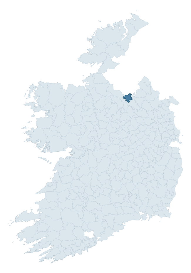
Where this barony sits in the Republic of Ireland
Geology and preservation
Bedrock geology shapes the landscape long before any settlement begins — controlling soil drainage, agricultural potential, the survival of upstanding monuments, and the preservation of buried archaeology. The figures below come from the Geological Survey Ireland 1:100,000 bedrock map.
The bedrock underlying Loughtee Lower is predominantly limestone (56% of the barony by area), laid down during the Carboniferous period (91% by area, around 359 to 299 million years ago). Limestone is the most heritage-rich bedrock in Ireland. It supports fertile, well-drained soils that favoured dense Early Medieval settlement and Norman manorial agriculture, and it weathers into karst features — sinkholes, caves, swallow holes, and souterrains — that frequently carry archaeology. Where peat overlies limestone, organic preservation can be exceptional. A substantial secondary geology of shale (27%) adds further variety to the underlying landscape. The single largest mapped unit is the Dartry Limestone Formation (29% of the barony's bedrock).
Rock type composition
Largest mapped unit: Dartry Limestone Formation (29% of the barony)
Placename evidence
Logainm records 23 heritage-diagnostic placenames for Loughtee Lower, drawn from townland and civil-parish names across the barony. The dominant stratum is Early Christian ecclesiastical — cill-, teampall-, and domhnach-prefixed names that record the dense network of early church foundations established between the fifth and tenth centuries. The leading diagnostic roots are cill- (14 — church), ráth- (5 — earthen ringfort), and tuaim- (2 — burial mound). This is below the ROI average of 30.7 heritage placenames per barony, suggesting either lighter survey coverage or a townland-naming tradition that draws more on generic landscape vocabulary. The presence of multiple heritage strata side by side indicates layered occupation of the landscape across successive prehistoric and historic periods. Logainm records 172 placenames for Loughtee Lower (predominantly townland names). Of these, 23 (13%) carry one of the diagnostic Gaelic roots tracked above; the remainder draw on more generic landscape vocabulary that does not encode a heritage period.
Pre-Christian / Early Medieval Defensive
| Root | Count | Meaning |
|---|---|---|
| ráth- | 5 | earthen ringfort |
| lios- | 1 | ringfort or enclosure |
| dún- | 1 | hilltop or promontory fort |
Early Christian Ecclesiastical
| Root | Count | Meaning |
|---|---|---|
| cill- | 14 | church (early) |
Burial, Ritual, and Norse-Contact
| Root | Count | Meaning |
|---|---|---|
| tuaim- | 2 | burial mound |
Other baronies in Cavan
About this profile
Click any section below to expand.
What is a barony?
A barony is a historic administrative unit in Ireland, broadly equivalent to an English hundred. The 280 baronies used here are from the OSi 2019 National Statutory Boundaries (generalised 20m), covering the 26 counties of the Republic of Ireland. Baronies derive from the Norman period, were formalised in the 17th century, and have not been redrawn for statistical purposes. They vary enormously in area, from compact urban baronies in Dublin to vast upland baronies in Connacht, and should not be compared by raw site count without accounting for area differences.
What counts as a site?
This profile combines three distinct heritage registers, each with its own definition of what constitutes a recordable site:
- Archaeological sites (NMS). The National Monuments Service Sites and Monuments Record (SMR) catalogues every known archaeological monument or site of archaeological interest in the Republic, from prehistoric burial mounds and ringforts to medieval churches and post-medieval defensive works. Inclusion does not require legal protection — only that the site has been identified, surveyed, and assessed as having archaeological value. A separate subset of these sites lies within a recorded protection zone, which gives them statutory protection under the National Monuments Acts.
- Listed buildings (NIAH). The National Inventory of Architectural Heritage records buildings of architectural, historical, archaeological, artistic, cultural, scientific, social, or technical interest. Each surveyed structure is appraised on a five-tier scale: International, National, Regional, Local, and Record-Only. The NIAH appraisal is informational rather than strictly statutory, but it underpins local-authority Record of Protected Structures (RPS) listings.
- Heritage placenames (Logainm). Logainm is the authoritative database of Irish placenames maintained by the Placenames Branch. This profile applies a heritage-diagnostic classifier to the Irish-language form of each townland name, flagging roots that signal defensive sites (ráth-, lios-, dún-, caiseal-, cathair-), ecclesiastical foundations (cill-, teampall-, domhnach-, mainistir-), prehistoric burial-ritual features (tuaim-, carn-, leaba-), or Norse-contact settlement (gall-). Townlands without one of these diagnostic roots are not flagged here — they may still carry historical significance, but that significance is not encoded in the name itself.
Editorial principles
The narrative sections of this profile follow several explicit principles:
- Evidential. Every claim about this barony’s heritage character is anchored in the underlying register data. Where a site count, a placename count, or a percentile rank is cited, it is computed from the source datasets at export time, not estimated.
- Comparative. Counts and metrics are reported alongside their percentile rank against the other 279 ROI baronies. A barony with 50 ringforts in absolute terms could be unusually high or unusually low depending on its size and regional context; percentile ranking removes that ambiguity.
- Transparent on limits. Where a register has known coverage gaps, survey biases, or data-quality issues that affect this barony’s figures, the profile flags them rather than presenting the numbers as definitive.
- No interpretation beyond what the data supports. The narrative does not speculate about historical events, social dynamics, or cultural meaning beyond what the recorded heritage and placename evidence directly attests.
Data caveats and limits
- NMS Sites and Monuments Record is the product of survey campaigns conducted at different intensities across different counties and decades. Some baronies have been surveyed more thoroughly than others, and absolute counts should be read in that light. Sites destroyed by development before survey are typically not represented; sites in heavily forested or upland terrain are sometimes under-recorded.
- NIAH coverage is broadly complete for the Republic of Ireland but the survey was conducted on a rolling county-by-county basis, and the most recent appraisal date varies. Buildings demolished or substantially altered after their original survey may still appear in the register; conversely, recent buildings of merit may not yet have been appraised.
- Logainm classification applies a deliberately conservative pattern-matching approach to the Irish-language townland forms. The classifier prioritises true positives over recall: a townland may carry a heritage signal that the classifier doesn’t recognise, particularly where the diagnostic root has been heavily anglicised or where the townland name draws on a less common term. The 60,000+ townland records and ~9,800 classified placenames give a substantial signal at barony scale, but individual townland names should be checked against Logainm directly for definitive interpretation.
- Period attribution. The chronological distribution reflects only those NMS sites that carry a recognised period attribution in the source data. Sites listed as “Unknown” period are excluded from the dated subset.
- Boundary changes. Some baronies have undergone minor boundary adjustments since their 19th-century definition; the OSi 2019 generalised boundaries used here are the current statutory definition and may differ slightly from historical maps in border areas.
- Bedrock geology is mapped at 1:100,000 scale, which means local variation within a barony — small pockets of different rock type, mineral veins, alluvium overlying bedrock — is generalised. The dominant-system and rocktype figures are area-weighted, so a barony reading “70% Carboniferous limestone” may still contain small but archaeologically important pockets of older or younger rock. Around 3% of GSI polygons do not match the lexicon and contribute no rocktype or system attribution.
Data sources
- National Monuments Service — Sites and Monuments Record (SMR) https://data.gov.ie/dataset/national-monuments-service-archaeological-survey-of-ireland
- National Inventory of Architectural Heritage (NIAH) https://data.gov.ie/dataset/national-inventory-of-architectural-heritage-niah-national-dataset
- Logainm — Placenames Database of Ireland https://www.logainm.ie/
- Ordnance Survey Ireland — National Statutory Barony Boundaries 2019 https://data-osi.opendata.arcgis.com/
- EURODEM — European Digital Elevation Model https://www.mapsforeurope.org/datasets/euro-dem
- ESA WorldCover https://esa-worldcover.org/en
- Geological Survey Ireland — 1:100,000 Bedrock Geology https://www.gsi.ie/en-ie/data-and-maps/Pages/Bedrock.aspx
Explore more: Search any of the 280 ROI baronies, browse by historical province, or read the methodology and data sources for the full Republic of Ireland Heritage Tool.