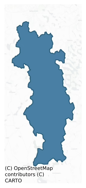
Tullyhunco is a barony of County Cavan, in the historical province of Ulster (Irish: Teallach Dhúnchadha), covering 165 km² of land. The barony records 168 NMS archaeological sites and 64 NIAH listed buildings, placing it at around the 14th percentile among 280 ROI baronies for sites per km². This means it is in the bottom fifth of all baronies for sites per km². Dated archaeological evidence runs from the Neolithic through to the Modern, spanning 6 of 9 archaeological periods, placing the barony in the 18th percentile among 280 ROI baronies for chronological depth. This means it is in the bottom fifth of all baronies for chronological depth. The largest dated subset of recorded sites dates to the Early Medieval. Logainm flags 22 placenames in the barony as carrying a recognised heritage root; the largest share — around 73% — are names associated with early Christian church and monastic foundations.

Heritage at a glance
Percentile rankings throughout this profile compare each barony only against the other 279 Republic of Ireland baronies.
The recorded heritage of Tullyhunco
The National Monuments Service Sites and Monuments Record (SMR) is the statutory inventory of archaeological sites for the Republic of Ireland, maintained by the Department of Tourism, Culture, Arts, Gaeltacht, Sport and Media. Sites recorded here include earthworks, ringforts, megalithic tombs, ecclesiastical remains, and post-medieval features; not every record is legally protected, but each is registered as a monument of archaeological interest.
The National Monuments Service records 168 archaeological sites in Tullyhunco, putting it at the 14th percentile among 280 ROI baronies for sites per km². This means it is in the bottom fifth of all baronies for sites per km². A sparse recorded total of this kind in Ireland often reflects survey priority rather than genuine absence of past activity. Protection coverage is near-universal — 165 sites (98%) fall within a recorded monument protection zone, indicating an extensively surveyed landscape. The dominant category is defensive sites — ringforts, enclosures, hillforts, and stone forts (128 sites, 76% of the record). Ringfort – rath is the most prevalent type, making up 48% of the barony's recorded sites (80 records) — well above the ROI average of 20% across all baronies where this type occurs. Ringfort – rath is an earthen ringfort enclosed by a bank and external ditch — the most common Early Medieval farmstead, broadly dated 500–1000 AD. Other significant types include Crannog (28) and Enclosure (8). Crannog is an artificial or partly artificial island built up on a lake or river bed, in use from the 6th to 17th centuries AD; Enclosure is a banked or ditched feature of uncertain type, used as a catch-all where the original function cannot be determined from surface evidence. Across the barony's 165 km², this gives a recorded density of 1.02 sites per km².
Most common monument types
Hover or tap a monument type to see its definition.
| Type | Count |
|---|---|
| Ringfort – rath an earthen ringfort enclosed by a bank and external ditch — the most common Early Medieval farmstead, broadly dated 500–1000 AD | 80 |
| Crannog an artificial or partly artificial island built up on a lake or river bed, in use from the 6th to 17th centuries AD | 28 |
| Enclosure a banked or ditched feature of uncertain type, used as a catch-all where the original function cannot be determined from surface evidence | 8 |
| Cairn – unclassified a stone mound that cannot be assigned to a specific cairn type | 6 |
| Castle – unclassified a castle whose form cannot be precisely classified, dating somewhere between the late 12th and 16th centuries | 5 |
| Graveyard a burial area associated with a church, in use from the medieval period onwards | 5 |
| Ritual site – holy well a well or spring traditionally associated with a saint, often credited with healing properties; many trace earlier ritual origins but devotion is documented from the medieval period onwards | 4 |
| Church a building used for public Christian worship, of any date from c. 500 AD onwards | 3 |
Chronological distribution
The dated archaeological record for Tullyhunco spans from the Neolithic through to the Modern, with activity attested across 6 of 9 archaeological periods. This is the 18th percentile across ROI baronies — a relatively narrow chronological band, with much of Irish prehistory not represented in the dated record. The record is periodic rather than continuous: the Middle Late Bronze Age, and Medieval periods fall inside the chronological span but record no dated sites — likely reflecting either genuine settlement discontinuity or limits of survey attribution. Activity concentrates most heavily in the Early Medieval (115 sites, 76% of dated material), with the Iron Age forming a secondary peak (14 sites, 9%). A further 17 recorded sites (10% of the overall NMS register for the barony) carry no period attribution — appearing as 'Unknown' in the bar chart below. This typically reflects either records that pre-date the standardised period vocabulary or sites awaiting specialist dating review, rather than a genuine absence of chronological evidence.
Sample of recorded monuments
Show 25 sample monuments (of 168 total)
A representative sample of 25 recorded monuments drawn from the barony’s 168 total NMS entries. Sites within a recorded monument protection zone and rarer site types are prioritised so the list shows a meaningful cross-section rather than only the most common type. Each entry shows the official Sites and Monuments Record reference number and the description published by the National Monuments Service.
Hilltop enclosure
Not marked as an antiquity on any OS ed. but known locally as a 'fort'. Oval area (int. dims. c. 160m NE-SW; 100m NW-SE) enclosed by a low earthen bank and a wide, shallow fosse, both of which have been modified and…
Not marked as an antiquity on any OS ed. but known locally as a 'fort'. Oval area (int. dims. c. 160m NE-SW; 100m NW-SE) enclosed by a low earthen bank and a wide, shallow fosse, both of which have been modified and incorporated into the field boundary, the area NE of which has been levelled leaving nothing visible at ground level. The site is divided into two roughly equal portions by a field boundary running NW-SE. Original entrance not recognisable.
The above description is derived from the published 'Archaeological Inventory of County Cavan' (Dublin: Stationery Office, 1995). In certain instances the entries have been revised and updated in the light of recent research.
Date of upload/revision: 22 December 2008
Megalithic tomb – passage tomb
Situated on the summit of a ridge and with commanding views in all directions. A large, round cairn, some 3m high, is much denuded and greatly disturbed by field fences. Richardson, writing c. 1739, (quoted by Paterson,…
Situated on the summit of a ridge and with commanding views in all directions. A large, round cairn, some 3m high, is much denuded and greatly disturbed by field fences. Richardson, writing c. 1739, (quoted by Paterson, Gaffikin and Davies 1938), recorded the name of the site as 'Cam Dalian' and claimed that a passage was discovered in the cairn 'about twenty-five years ago' and that 'severall urns, 5 large skulls and a great deal of burnt bones' were found in one of three 'apartments' there. This account would suggest that the cairn may have covered a passage tomb. Richardson also noted, just S of the cairn, a square enclosure about twenty yards across bounded by 'large stones set deep in the ground', and 'in the circuit of the hill . . . four small plots of ground of a circular figure inclosed with large stones, all of which are old burial places.' These have not been located. (Paterson, Gaffikin and Davies 1938, 143-5)
The above description is derived from the published 'Archaeological Inventory of County Cavan' (Dublin: Stationery Office, 1995). In certain instances the entries have been revised and updated in the light of recent research.
Date of upload/revision: 22 December 2008
Road – unclassified togher
A linear routeway (L c. 240m) described in italic lettering as 'The Togher' is shown on all OS 6-inch editions running WSW-ENE through low-lying wet marshy ground at this location (L c. 200m). Today the site is occupied…
A linear routeway (L c. 240m) described in italic lettering as 'The Togher' is shown on all OS 6-inch editions running WSW-ENE through low-lying wet marshy ground at this location (L c. 200m). Today the site is occupied by a narrow tarmacadamed road which is very susceptible to flooding during wet weather.
The above description is derived from the published 'Archaeological Inventory of County Cavan' (Dublin: Stationery Office, 1995). In certain instances the entries have been revised and updated in the light of recent research.
Date of upload: 22 December 2008
Amended: 18 March 2021
Courtyard
An early 17th-century courtyard much altered in late 18th century as evidenced by brickwork around windows. Features include an entrance gateway with rounded pedimented arch, the N pier inscribed with date of 1610 while…
An early 17th-century courtyard much altered in late 18th century as evidenced by brickwork around windows. Features include an entrance gateway with rounded pedimented arch, the N pier inscribed with date of 1610 while the S pier carries the date 1789; two early 17th-century cut-stone doorways in N range; and a plaque bearing the Hamilton coat of arms set in wall of S range.
The above description is derived from the published 'Archaeological Inventory of County Cavan' (Dublin: Stationery Office, 1995). In certain instances the entries have been revised and updated in the light of recent research.
Date of upload/revision: 22 December 2008
Wall monument
The Archaeological Survey of Ireland (ASI) is in the process of providing information on all monuments on The Historic Environment Viewer (HEV). Currently the information for this record has not been uploaded. To…
The Archaeological Survey of Ireland (ASI) is in the process of providing information on all monuments on The Historic Environment Viewer (HEV). Currently the information for this record has not been uploaded. To access available information for research purposes please make an appointment in advance with the Archive Unit (open Fridays 10.00 am – 5.00 pm), Department of Culture, Heritage and the Gaeltacht, The Custom House, Dublin 1 D01W6XO or email nmarchive@chg.gov.ie.
Mass-rock
The Archaeological Survey of Ireland (ASI) is in the process of providing information on all monuments on The Historic Environment Viewer (HEV). Currently the information for this record has not been uploaded. To…
The Archaeological Survey of Ireland (ASI) is in the process of providing information on all monuments on The Historic Environment Viewer (HEV). Currently the information for this record has not been uploaded. To access available information for research purposes please make an appointment in advance with the Archive Unit (open Fridays 10.00 am – 5.00 pm), Department of Culture, Heritage and the Gaeltacht, The Custom House, Dublin 1 D01W6XO or email nmarchive@chg.gov.ie.
Ecclesiastical enclosure
Circular area (int. diam. 54m) enclosed by a well-built drystone wall which appears to have been erected on an earlier rampart. Original entrance not recognisable. A blocked-up holy well occurs inside the wall at NE…
Circular area (int. diam. 54m) enclosed by a well-built drystone wall which appears to have been erected on an earlier rampart. Original entrance not recognisable. A blocked-up holy well occurs inside the wall at NE (CV024-037003-). Believed locally to be a famine graveyard. (Davies 1948, 98)
The above description is derived from the published 'Archaeological Inventory of County Cavan' (Dublin: Stationery Office, 1995). In certain instances the entries have been revised and updated in the light of recent research.
Date of upload/revision: 22 December 2008
Megalithic tomb – court tomb
Situated near a stream on a flat patch of ground close to a rocky hillock. The remains of a dual court tomb are incorporated in a mound 28.5m long, 13.5m wide and about 0.5m high. At W, a court, perhaps originally of…
Situated near a stream on a flat patch of ground close to a rocky hillock. The remains of a dual court tomb are incorporated in a mound 28.5m long, 13.5m wide and about 0.5m high. At W, a court, perhaps originally of semicircular outline, leads to a gallery, 9m long, divided by jambs into three chambers. The front chamber, the biggest of the three, is built with larger orthostats than the other two and its long axis is out of line with that of the rest of the gallery. The remains of the eastern gallery consist now of a single chamber. About 2m W of this there are a number of low set stones of uncertain function. (de Valera and Ó Nualláin 1972, 126-7, No. 26)
The above description is derived from the published 'Archaeological Inventory of County Cavan' (Dublin: Stationery Office, 1995). In certain instances the entries have been revised and updated in the light of recent research.
Date of upload/revision: 22 December 2008
See linked document with details from Ruaidhrí de Valera and Seán Ó Nualláin, Survey of the Megalithic Tombs of Ireland. Volume III. Counties Galway, Roscommon, Leitrim, Longford, Westmeath, Laoighis, Offaly, Kildare, Cavan. (Dublin: Stationery Office, 1972).
Enclosure – large enclosure
Large subcircular raised area (int. dims. 83m N-S; 68m E-W) enclosed by an earthen bank best preserved from SW-N-NNE, and a fosse well-defined from NW-N-SSW only. Both bank and fosse have been disturbed by quarrying.…
Large subcircular raised area (int. dims. 83m N-S; 68m E-W) enclosed by an earthen bank best preserved from SW-N-NNE, and a fosse well-defined from NW-N-SSW only. Both bank and fosse have been disturbed by quarrying. Depression in bank with accompanying causeway at ESE may represent original entrance. Within the interior at S is a short segment of earthen bank extending 5m N from the enclosing bank. Situated at the foot of a high drumlin hill.
The above description is derived from the published 'Archaeological Inventory of County Cavan' (Dublin: Stationery Office, 1995). In certain instances the entries have been revised and updated in the light of recent research.
Date of upload/revision: 22 December 2008
Megalithic structure
According to an account in the National Museum (NMI files, 1932) this monument comprised '20 large boulders of local greenstone 32 feet long by 28 feet wide' (c. 9.75m x 8.5m). The stones were 3 to 4 feet (c. 0.9m to…
According to an account in the National Museum (NMI files, 1932) this monument comprised '20 large boulders of local greenstone 32 feet long by 28 feet wide' (c. 9.75m x 8.5m). The stones were 3 to 4 feet (c. 0.9m to 1.2m) in height, 3 feet wide and up to 3 feet in the ground. At the W end there was an entrance to a passage 20 feet (c. 6.1m) long. A lintel above the entrance measured 7 feet (c. 2.1m) by 7 feet by 4 feet. There was paving on the floor of the inner end of the passage with some trace of burning. No finds were reported. The site was levelled in the 1940s or 1950s and the stones used in road construction. There are now no surface remains. The landowner remembers the structure as consisting of three particularly massive boulders upon which rested a fourth stone. Formerly situated in fertile pasture sloping quite steeply from NW to SE. There is a substantial pond adjacent to the site at the NE. This site may have been some form of megalithic monument but its nature is uncertain.
The above description is derived from the published 'Archaeological Inventory of County Cavan' (Dublin: Stationery Office, 1995). In certain instances the entries have been revised and updated in the light of recent research.
Date of upload/revision: 22 December 2008
Mausoleum
What may have been the SW corner tower of the bawn (CV019-008001-) could have been adapted as a mausoleum with a corbelled roof over the ground floor. An undated but probably 19th century headstone which commemorates…
What may have been the SW corner tower of the bawn (CV019-008001-) could have been adapted as a mausoleum with a corbelled roof over the ground floor. An undated but probably 19th century headstone which commemorates Rev. George Carson and his wife Mary that was in the tower is now at Croghan House c. 130m to the N. He may have been a minister at the Presbyterian church in Croaghan, c. 270m to the SSW. The headstone is inscribed in both cursive and roman lettering and reads: Here lies the body of the Revd. George Carson / wishing for the Resurrection of the Just / Who when living was / a S____ of Christian liberty / and to whom Christ ___ as both / Vici V____ & Veritus / as also Mary Carson his wife
Compiled by: Michael Moore
Date of upload: 15 April, 2016
Mound
The Archaeological Survey of Ireland (ASI) is in the process of providing information on all monuments on The Historic Environment Viewer (HEV). Currently the information for this record has not been uploaded. To…
The Archaeological Survey of Ireland (ASI) is in the process of providing information on all monuments on The Historic Environment Viewer (HEV). Currently the information for this record has not been uploaded. To access available information for research purposes please make an appointment in advance with the Archive Unit (open Fridays 10.00 am – 5.00 pm), Department of Culture, Heritage and the Gaeltacht, The Custom House, Dublin 1 D01W6XO or email nmarchive@chg.gov.ie.
Barrow – stepped barrow
Located in improved pasture on top of a natural hillock, which is nestled in a low-lying landscape with higher drumlins all around NE-S-NW, and Carn Lough is c. 240m to the N. It is visible on the OSi series of aerial…
Located in improved pasture on top of a natural hillock, which is nestled in a low-lying landscape with higher drumlins all around NE-S-NW, and Carn Lough is c. 240m to the N. It is visible on the OSi series of aerial photographs (2005) and on Bing images (c. 2013), and it was first noticed by Katherine McCormack. This is a circular area (diam. 40m N-S; 37m E-W) defined by a steep scarp (at W: Wth 4.4m; H 1.25m) with a berm (at W: Wth 3m) separating it from a scarp or natural slope (at W: Wth 7.0m; H 1.4m) SW-W-NNW. The perimeter declines to low scarp (Wth 4.0m; H 0.8m) NNW-SE and merges into a natural scarped slope (Wth 17.9m; H 3.4m) SE-SW. There are ramp entrances at N (Wth 3.2m) and at NNE (Wth 3.5m), which are c. 4m apart, and there are traces of a fosse (Wth of top 5.75m; Wth of base 1.25m; D 0.1m) NW-NE. The interior slopes down slightly to the N and there is an enclosure inside the perimeter at S. This is a penannular area (dims c. 12m E-W; c. 11.5m N-S) defined by a slight scarp ENE-SE (Wth 2.2m; H 0.05m) and SW-WNW (Wth 1.9m; H 0.3m), but the perimeter is incorporated into that of the platform SE-SW and is absent elsewhere.
Compiled by: Michael Moore
Date of revised upload: 24 March, 2014
Souterrain
At Cloncose rath (CV014-012001-). The entrance to the rath is at NE. Running W from this to the centre of the internal area is a long, shallow depression (L 28.3m; Wth 2.4m; D 0.3m) which may represent the remains of a…
At Cloncose rath (CV014-012001-). The entrance to the rath is at NE. Running W from this to the centre of the internal area is a long, shallow depression (L 28.3m; Wth 2.4m; D 0.3m) which may represent the remains of a collapsed souterrain.
The above description is derived from the published 'Archaeological Inventory of County Cavan' (Dublin: Stationery Office, 1995). In certain instances the entries have been revised and updated in the light of recent research.
Date of upload/revision: 22 December 2008
Cist
Discovered at the E end of Killarah cairn (CV014-043002-). Investigated by Ó Ríordáin (1933, 167-71) in 1932. The grave comprised a limestone slab c. 2.14m x 1.21m 'which rested in a sloping position on a stone placed…
Discovered at the E end of Killarah cairn (CV014-043002-). Investigated by Ó Ríordáin (1933, 167-71) in 1932. The grave comprised a limestone slab c. 2.14m x 1.21m 'which rested in a sloping position on a stone placed beneath it. The front or eastern end of the grave was closed by a low, roughly built, dry-stone wall which formed the arc of a circle of which the eastern end of the slab was the chord. The space between the wall and the slab was closed by flat stones, some of which had collapsed into the grave'. Within the cist he found both inhumed and cremated human remains but no grave-goods. He believed that the cist represented a secondary burial 'built at some time after the cairn and somewhat outside its periphery' and suggested a tentative Middle Bronze Age date for it. A large slab is visible within a hole which has been dug into the lower edge of the cairn at ENE, which is possibly the covering stone of the cist noted above.
The above description is derived from the published 'Archaeological Inventory of County Cavan' (Dublin: Stationery Office, 1995). In certain instances the entries have been revised and updated in the light of recent research.
Date of upload/revision: 22 December 2008
This monument is subject to a preservation order made under the National Monuments Acts 1930 to 2014 (PO no. 7/1932).
Bawn
In the Hearth Money Roll during the reign of Charles II (1660-85) Dame Mary Craig was charged had two hearths at a house at Croghan (Davies 1948a, 124). A subrectangular area described as the site of an Old Castle is…
In the Hearth Money Roll during the reign of Charles II (1660-85) Dame Mary Craig was charged had two hearths at a house at Croghan (Davies 1948a, 124). A subrectangular area described as the site of an Old Castle is marked on the 1835 ed. of the OS 6-inch map and it is also outlined on the 1910 ed. as a subrectangular area (dims c. 55m E-W; c. 50m N-S) defined by field banks and what is probably a double field bank on the E side and adjacent pares of the N and S. A circular, free-standing, two-storey tower (int. diam. 2.8m) constructed of rubble masonry survives at the SW angle with the doorway facing NE into the bawn enclosure and simple rectangular slit windows. This may have been adapted as a mausoleum with a corbelled roof over the ground floor. (Wilsdon 2010, 186-91)
An undated but probably 19th century headstone which commemorates Rev. George Carson and his wife Mary that was in the tower is now at Croghan House c. 130m to the N. He may have been a minister at the Presbyterian church in Croaghan, c. 270m to the SSW. The headstone or memorial is inscribed in both cursive and roman lettering and reads: Here lies the body of the Revd. George Carson / wishing for the Resurrection of the Just / Who when living was / a S____ of Christian liberty / and to whom Christ ___ as both / Vici V____ & Veritus / as also Mary Carson his wife
The above description is derived from the published 'Archaeological Inventory of County Cavan' (Dublin: Stationery Office, 1995). In certa…
Bawn
A bawn wall of the Plantation period, constructed of stone and clay was, according to Davies, (1948a, 124-5) situated on an old road a little below the summit of Castlepoles hill. However, local tradition identifies the…
A bawn wall of the Plantation period, constructed of stone and clay was, according to Davies, (1948a, 124-5) situated on an old road a little below the summit of Castlepoles hill. However, local tradition identifies the site of the castle as being c. 85m WSW of this (local information). There are no visible surface remains at either location.
Date of upload: 12 April, 2016
Souterrain
Local tradition refers to a tunnel running off Dingins rath (CV030-015001-), which suggests a souterrain site.
The above description is derived from the published 'Archaeological Inventory of County Cavan' (Dublin:…
Local tradition refers to a tunnel running off Dingins rath (CV030-015001-), which suggests a souterrain site.
The above description is derived from the published 'Archaeological Inventory of County Cavan' (Dublin: Stationery Office, 1995). In certain instances the entries have been revised and updated in the light of recent research.
Date of upload/revision: 22 December 2008
Cist
Identified by Davies (ITA Survey 1941) on a dry ridge on sandy soil overlooking Lough Gowna to the W. Two 'buttons' were found within the cist and slightly to the S in the same field some bronze implements were…
Identified by Davies (ITA Survey 1941) on a dry ridge on sandy soil overlooking Lough Gowna to the W. Two 'buttons' were found within the cist and slightly to the S in the same field some bronze implements were discovered. Not visible at ground level.
The above description is derived from the published 'Archaeological Inventory of County Cavan' (Dublin: Stationery Office, 1995). In certain instances the entries have been revised and updated in the light of recent research.
Date of upload/revision: 22 December 2008
Well
The Archaeological Survey of Ireland (ASI) is in the process of providing information on all monuments on The Historic Environment Viewer (HEV). Currently the information for this record has not been uploaded. To…
The Archaeological Survey of Ireland (ASI) is in the process of providing information on all monuments on The Historic Environment Viewer (HEV). Currently the information for this record has not been uploaded. To access available information for research purposes please make an appointment in advance with the Archive Unit (open Fridays 10.00 am – 5.00 pm), Department of Culture, Heritage and the Gaeltacht, The Custom House, Dublin 1 D01W6XO or email nmarchive@chg.gov.ie.
Church
Church with nave (int. dims. c. 20m E-W; c. 8m N-S) and large south transept (dims. c. 9m E-W; c. 9m N-S) situated within a former embanked enclosure. Hachured arc marked on current OS indicates an enclosure running…
Church with nave (int. dims. c. 20m E-W; c. 8m N-S) and large south transept (dims. c. 9m E-W; c. 9m N-S) situated within a former embanked enclosure. Hachured arc marked on current OS indicates an enclosure running from SSW-W-NNE which is no longer visible at ground level. Graveyard extends beyond line of enclosure. According to Davies' (1948, 97-8) reading of papal registers, there may have been a church on this site as early as 1433. A heraldic plaque on S gable of transept indicates that present structure was built by Lord Southwell in 1688. Davies described nave as having a W door, two N windows and an E window now blocked. All windows in church are round-headed with two rounded lights surmounted by a circular ope. He also noted 'the fine Jacobean door in S transept leading down to a font with elaborate Jacobean canopy and hence into the nave, or upwards to a gallery beneath the brick vaulting of the transept'. The E portion of transept was walled off and probably used as a vestry. Ornamental terminals on gable-coping.
This structure has been identified as being of National importance.
The above description is derived from the published 'Archaeological Inventory of County Cavan' (Dublin: Stationery Office, 1995). In certain instances the entries have been revised and updated in the light of recent research.
Date of upload/revision: 16 January 2018
Standing stone
An earlier report (OPW 1968) recorded that this standing stone had been moved from the location marked on the OS eds. to a point 6m to E. Original position was just SSE of the summit of a high drumlin ridge. It…
An earlier report (OPW 1968) recorded that this standing stone had been moved from the location marked on the OS eds. to a point 6m to E. Original position was just SSE of the summit of a high drumlin ridge. It comprised an irregular, hard, composite boulder (H 1.15m; dims. 0.85m x 0.62m) noteworthy for the numerous streaks of quartzite in its composition. The stone has been removed from the second position in recent years and is now unlocated.
The above description is derived from the published 'Archaeological Inventory of County Cavan' (Dublin: Stationery Office, 1995). In certain instances the entries have been revised and updated in the light of recent research.
Date of upload/revision: 22 December 2008
Standing stone
Situated on precipitous ground ESE of Bruse Hill. It has recently been knocked over and broken and now lies flat in the field. Roughly rectangular in plan (H 1.57m; dims 0.85m x 0.28m).Known locally as 'an cloch óir',…
Situated on precipitous ground ESE of Bruse Hill. It has recently been knocked over and broken and now lies flat in the field. Roughly rectangular in plan (H 1.57m; dims 0.85m x 0.28m).Known locally as 'an cloch óir', rather than 'an cloch mor'.
The above description is derived from the published 'Archaeological Inventory of County Cavan' (Dublin: Stationery Office, 1995). In certain instances the entries have been revised and updated in the light of recent research.
Date of upload/revision: 22 December 2008
Ringfort – unclassified
Marked 'Fort' on OS 1836 and 1876 eds. An earlier report (OPW 1977) recorded that the site had been levelled in 1976. Outline of perimeter, enclosing a circular area (int. diam. c. 3m) can still be traced. Otherwise not…
Marked 'Fort' on OS 1836 and 1876 eds. An earlier report (OPW 1977) recorded that the site had been levelled in 1976. Outline of perimeter, enclosing a circular area (int. diam. c. 3m) can still be traced. Otherwise not visible at ground level.
The above description is derived from the published 'Archaeological Inventory of County Cavan' (Dublin: Stationery Office, 1995). In certain instances the entries have been revised and updated in the light of recent research.
Date of upload/revision: 22 December 2008
Ringfort – rath
Marked 'Fort' on OS 1836 and 1876 eds. Situated close to the summit of a drumlin hill. Not visible at ground level.
The above description is derived from the published 'Archaeological Inventory of County Cavan'…
Marked 'Fort' on OS 1836 and 1876 eds. Situated close to the summit of a drumlin hill. Not visible at ground level.
The above description is derived from the published 'Archaeological Inventory of County Cavan' (Dublin: Stationery Office, 1995). In certain instances the entries have been revised and updated in the light of recent research.
Date of upload/revision: 22 December 2008
Listed buildings
The National Inventory of Architectural Heritage (NIAH) is a state survey appraising buildings of architectural, historical, archaeological, artistic, cultural, scientific, social, or technical interest. Each surveyed structure receives a rating from International (the highest, for buildings of European importance) through National, Regional, Local, and Record-Only.
The NIAH records 64 listed buildings in Tullyhunco (33rd percentile across ROI baronies). The highest-graded structures include 2 of National significance. The Republic holds 937 National-graded buildings in total, so this barony accounts for around 0% of the national total. Construction dates concentrate most heavily in the Victorian (1830-1900) period. The most-recorded building type is church/chapel (14 examples, 22% of the listed stock).
Terrain and environment
Mean elevation across the barony is 81m — the 42nd percentile among 280 ROI baronies for elevation. This means it is in the lower half of all baronies for elevation. Elevation matters for heritage because higher-altitude baronies typically favour defensive monuments — ringforts and hilltop forts placed on prominent ground — while lowland baronies are more likely to carry the dense settlement and church networks of intensive agricultural landscapes. A maximum elevation of 257m gives the barony meaningful vertical relief. Mean slope is 5.1° — the 75th percentile among 280 ROI baronies for slope. This means it is in the top third of all baronies for slope. Slope is a key control on both land use and archaeological preservation: steep ground resists ploughing and tends to preserve earthworks intact, while gentle slopes favour intensive cultivation that damages or destroys surface archaeology over time. The Topographic Wetness Index averages 10.0, the 23rd percentile among 280 ROI baronies for wetness. This means it is in the bottom third of all baronies for wetness. This is well-drained ground by ROI standards — typical of upland or steeply-sloping country that sheds water rapidly. Drainage matters for heritage because poorly-drained ground preserves organic archaeology (wooden trackways, leather, textiles, and on rare occasions human remains) far better than free-draining soil; well-drained ground favours arable use but destroys organic material rapidly. The land-cover mosaic combines improved grassland (71%), woodland (23%), and open water (5%), giving a mixed agricultural and semi-natural landscape.
Terrain measurements
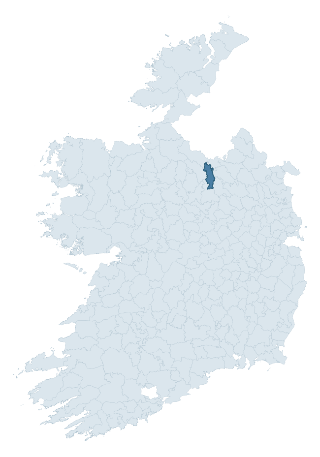
Where this barony sits in the Republic of Ireland
Geology and preservation
Bedrock geology shapes the landscape long before any settlement begins — controlling soil drainage, agricultural potential, the survival of upstanding monuments, and the preservation of buried archaeology. The figures below come from the Geological Survey Ireland 1:100,000 bedrock map.
The bedrock underlying Tullyhunco is predominantly greywacke and shale (39% of the barony by area), laid down during the Ordovician period (61% by area, around 485 to 444 million years ago). A substantial secondary geology of greywacke (21%) and limestone (18%) adds further variety to the underlying landscape. The single largest mapped unit is the Coronea Formation (39% of the barony's bedrock). With 7 distinct rock types mapped, the barony sits in the top third of ROI baronies for geological diversity (73rd percentile) — typically a sign of complex tectonic history or coastal mosaics of differing rock units.
Rock type composition
Largest mapped unit: Coronea Formation (39% of the barony)
Placename evidence
Logainm records 22 heritage-diagnostic placenames for Tullyhunco, drawn from townland and civil-parish names across the barony. The dominant stratum is Early Christian ecclesiastical — cill-, teampall-, and domhnach-prefixed names that record the dense network of early church foundations established between the fifth and tenth centuries. The leading diagnostic roots are cill- (14 — church), ráth- (2 — earthen ringfort), and lios- (1 — ringfort or enclosure). This is below the ROI average of 30.7 heritage placenames per barony, suggesting either lighter survey coverage or a townland-naming tradition that draws more on generic landscape vocabulary. The presence of multiple heritage strata side by side indicates layered occupation of the landscape across successive prehistoric and historic periods. Logainm records 182 placenames for Tullyhunco (predominantly townland names). Of these, 22 (12%) carry one of the diagnostic Gaelic roots tracked above; the remainder draw on more generic landscape vocabulary that does not encode a heritage period.
Pre-Christian / Early Medieval Defensive
| Root | Count | Meaning |
|---|---|---|
| ráth- | 2 | earthen ringfort |
| lios- | 1 | ringfort or enclosure |
| dún- | 1 | hilltop or promontory fort |
Early Christian Ecclesiastical
| Root | Count | Meaning |
|---|---|---|
| cill- | 14 | church (early) |
| domhnach- | 1 | pre-Patrician or earliest Patrician church |
| díseart- | 1 | hermitage |
Burial, Ritual, and Norse-Contact
| Root | Count | Meaning |
|---|---|---|
| carn- | 1 | cairn |
| leacht- | 1 | grave monument |
Other baronies in Cavan
About this profile
Click any section below to expand.
What is a barony?
A barony is a historic administrative unit in Ireland, broadly equivalent to an English hundred. The 280 baronies used here are from the OSi 2019 National Statutory Boundaries (generalised 20m), covering the 26 counties of the Republic of Ireland. Baronies derive from the Norman period, were formalised in the 17th century, and have not been redrawn for statistical purposes. They vary enormously in area, from compact urban baronies in Dublin to vast upland baronies in Connacht, and should not be compared by raw site count without accounting for area differences.
What counts as a site?
This profile combines three distinct heritage registers, each with its own definition of what constitutes a recordable site:
- Archaeological sites (NMS). The National Monuments Service Sites and Monuments Record (SMR) catalogues every known archaeological monument or site of archaeological interest in the Republic, from prehistoric burial mounds and ringforts to medieval churches and post-medieval defensive works. Inclusion does not require legal protection — only that the site has been identified, surveyed, and assessed as having archaeological value. A separate subset of these sites lies within a recorded protection zone, which gives them statutory protection under the National Monuments Acts.
- Listed buildings (NIAH). The National Inventory of Architectural Heritage records buildings of architectural, historical, archaeological, artistic, cultural, scientific, social, or technical interest. Each surveyed structure is appraised on a five-tier scale: International, National, Regional, Local, and Record-Only. The NIAH appraisal is informational rather than strictly statutory, but it underpins local-authority Record of Protected Structures (RPS) listings.
- Heritage placenames (Logainm). Logainm is the authoritative database of Irish placenames maintained by the Placenames Branch. This profile applies a heritage-diagnostic classifier to the Irish-language form of each townland name, flagging roots that signal defensive sites (ráth-, lios-, dún-, caiseal-, cathair-), ecclesiastical foundations (cill-, teampall-, domhnach-, mainistir-), prehistoric burial-ritual features (tuaim-, carn-, leaba-), or Norse-contact settlement (gall-). Townlands without one of these diagnostic roots are not flagged here — they may still carry historical significance, but that significance is not encoded in the name itself.
Editorial principles
The narrative sections of this profile follow several explicit principles:
- Evidential. Every claim about this barony’s heritage character is anchored in the underlying register data. Where a site count, a placename count, or a percentile rank is cited, it is computed from the source datasets at export time, not estimated.
- Comparative. Counts and metrics are reported alongside their percentile rank against the other 279 ROI baronies. A barony with 50 ringforts in absolute terms could be unusually high or unusually low depending on its size and regional context; percentile ranking removes that ambiguity.
- Transparent on limits. Where a register has known coverage gaps, survey biases, or data-quality issues that affect this barony’s figures, the profile flags them rather than presenting the numbers as definitive.
- No interpretation beyond what the data supports. The narrative does not speculate about historical events, social dynamics, or cultural meaning beyond what the recorded heritage and placename evidence directly attests.
Data caveats and limits
- NMS Sites and Monuments Record is the product of survey campaigns conducted at different intensities across different counties and decades. Some baronies have been surveyed more thoroughly than others, and absolute counts should be read in that light. Sites destroyed by development before survey are typically not represented; sites in heavily forested or upland terrain are sometimes under-recorded.
- NIAH coverage is broadly complete for the Republic of Ireland but the survey was conducted on a rolling county-by-county basis, and the most recent appraisal date varies. Buildings demolished or substantially altered after their original survey may still appear in the register; conversely, recent buildings of merit may not yet have been appraised.
- Logainm classification applies a deliberately conservative pattern-matching approach to the Irish-language townland forms. The classifier prioritises true positives over recall: a townland may carry a heritage signal that the classifier doesn’t recognise, particularly where the diagnostic root has been heavily anglicised or where the townland name draws on a less common term. The 60,000+ townland records and ~9,800 classified placenames give a substantial signal at barony scale, but individual townland names should be checked against Logainm directly for definitive interpretation.
- Period attribution. The chronological distribution reflects only those NMS sites that carry a recognised period attribution in the source data. Sites listed as “Unknown” period are excluded from the dated subset.
- Boundary changes. Some baronies have undergone minor boundary adjustments since their 19th-century definition; the OSi 2019 generalised boundaries used here are the current statutory definition and may differ slightly from historical maps in border areas.
- Bedrock geology is mapped at 1:100,000 scale, which means local variation within a barony — small pockets of different rock type, mineral veins, alluvium overlying bedrock — is generalised. The dominant-system and rocktype figures are area-weighted, so a barony reading “70% Carboniferous limestone” may still contain small but archaeologically important pockets of older or younger rock. Around 3% of GSI polygons do not match the lexicon and contribute no rocktype or system attribution.
Data sources
- National Monuments Service — Sites and Monuments Record (SMR) https://data.gov.ie/dataset/national-monuments-service-archaeological-survey-of-ireland
- National Inventory of Architectural Heritage (NIAH) https://data.gov.ie/dataset/national-inventory-of-architectural-heritage-niah-national-dataset
- Logainm — Placenames Database of Ireland https://www.logainm.ie/
- Ordnance Survey Ireland — National Statutory Barony Boundaries 2019 https://data-osi.opendata.arcgis.com/
- EURODEM — European Digital Elevation Model https://www.mapsforeurope.org/datasets/euro-dem
- ESA WorldCover https://esa-worldcover.org/en
- Geological Survey Ireland — 1:100,000 Bedrock Geology https://www.gsi.ie/en-ie/data-and-maps/Pages/Bedrock.aspx
Explore more: Search any of the 280 ROI baronies, browse by historical province, or read the methodology and data sources for the full Republic of Ireland Heritage Tool.