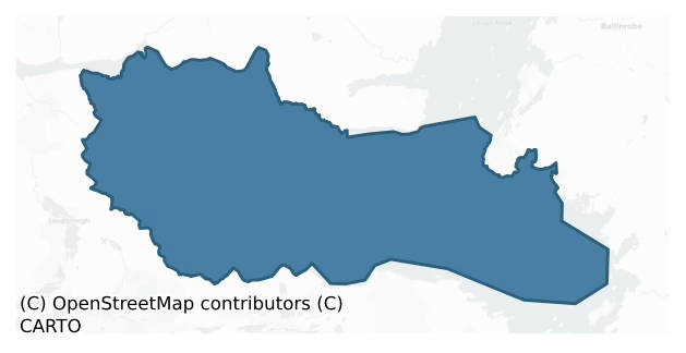
Ross is a barony of County Galway, in the historical province of Connacht (Irish: An Ros), covering 306 km² of land. The barony records 129 NMS archaeological sites and 36 NIAH listed buildings, placing it at around the 1st percentile among 280 ROI baronies for sites per km². This means it is in the bottom tenth of all baronies for sites per km². Dated archaeological evidence runs from the Neolithic through to the Modern, spanning 8 of 9 archaeological periods, placing the barony in the 54th percentile among 280 ROI baronies for chronological depth. This means it is in the upper half of all baronies for chronological depth. The largest dated subset of recorded sites dates to the Early Medieval.
Heritage at a glance
Percentile rankings throughout this profile compare each barony only against the other 279 Republic of Ireland baronies.
The recorded heritage of Ross
The National Monuments Service Sites and Monuments Record (SMR) is the statutory inventory of archaeological sites for the Republic of Ireland, maintained by the Department of Tourism, Culture, Arts, Gaeltacht, Sport and Media. Sites recorded here include earthworks, ringforts, megalithic tombs, ecclesiastical remains, and post-medieval features; not every record is legally protected, but each is registered as a monument of archaeological interest.
The National Monuments Service records 129 archaeological sites in Ross, putting it at the 1st percentile among 280 ROI baronies for sites per km². This means it is in the bottom tenth of all baronies for sites per km². A sparse recorded total of this kind in Ireland often reflects survey priority rather than genuine absence of past activity. Of these, 112 (87%) fall within a recorded monument protection zone. The record is dominated by ecclesiastical sites — churches, graveyards, and holy wells (43 sites, 33% of the total), with defensive sites forming a substantial secondary presence (24 sites, 19%). Ritual site – holy well is the most prevalent type, making up 9% of the barony's recorded sites (12 records) — well above the ROI average of 3% across all baronies where this type occurs. Ritual site – holy well is a well or spring traditionally associated with a saint, often credited with healing properties; many trace earlier ritual origins but devotion is documented from the medieval period onwards. Other significant types include Children's burial ground (10) and Church (8). Children's burial ground is an unconsecrated medieval and early-modern burial ground for unbaptised or stillborn children, often called a cillín or ceallúnach; Church is a building used for public Christian worship, of any date from c. 500 AD onwards. Across the barony's 306 km², this gives a recorded density of 0.42 sites per km².
Most common monument types
Hover or tap a monument type to see its definition.
| Type | Count |
|---|---|
| Ritual site – holy well a well or spring traditionally associated with a saint, often credited with healing properties; many trace earlier ritual origins but devotion is documented from the medieval period onwards | 12 |
| Children's burial ground an unconsecrated medieval and early-modern burial ground for unbaptised or stillborn children, often called a cillín or ceallúnach | 10 |
| Church a building used for public Christian worship, of any date from c. 500 AD onwards | 8 |
| Graveyard a burial area associated with a church, in use from the medieval period onwards | 7 |
| Ringfort – rath an earthen ringfort enclosed by a bank and external ditch — the most common Early Medieval farmstead, broadly dated 500–1000 AD | 7 |
| Enclosure a banked or ditched feature of uncertain type, used as a catch-all where the original function cannot be determined from surface evidence | 6 |
| Fulacht fia a horseshoe-shaped Bronze Age burnt mound built around a sunken trough beside a water source, traditionally interpreted as a cooking site | 5 |
| Ringfort – cashel the stone-walled equivalent of the rath, found mainly in upland or western areas, broadly dated 500–1000 AD | 4 |
Chronological distribution
The dated archaeological record for Ross spans from the Neolithic through to the Modern, with activity attested across 8 of 9 archaeological periods. Every period from earliest to latest is represented in the record — an unbroken sequence of dated activity across the full chronological span. Activity concentrates most heavily in the Early Medieval (36 sites, 48% of dated material), with the Iron Age forming a secondary peak (17 sites, 23%). A further 54 recorded sites (42% of the overall NMS register for the barony) carry no period attribution — appearing as 'Unknown' in the bar chart below. This typically reflects either records that pre-date the standardised period vocabulary or sites awaiting specialist dating review, rather than a genuine absence of chronological evidence.
Sample of recorded monuments
Show 25 sample monuments (of 129 total)
A representative sample of 25 recorded monuments drawn from the barony’s 129 total NMS entries. Sites within a recorded monument protection zone and rarer site types are prioritised so the list shows a meaningful cross-section rather than only the most common type. Each entry shows the official Sites and Monuments Record reference number and the description published by the National Monuments Service.
Standing stone – pair
On N side of Gleann Glaise overlooking the Bealnabrack River. Aligned N-S and 1.7m apart. Both stones are of white quartz. The N stone is squat and wedge-shaped in plan (H 0.5m); S stone is taller and rectangular in…
On N side of Gleann Glaise overlooking the Bealnabrack River. Aligned N-S and 1.7m apart. Both stones are of white quartz. The N stone is squat and wedge-shaped in plan (H 0.5m); S stone is taller and rectangular in plan (H 1.4m). (Ó Nualláin 1988, 195)
The above description is derived from the published 'Archaeological Inventory of County Galway Vol. I – West Galway'. Compiled by Paul Gosling (Dublin: Stationery Office, 1993).
Date of upload: 05 August 2010
Stone row
In a low-lying boggy area on the valley floor of Gleann Glaise a short distance to N of the Bealnabrack River. Comprises four white quartz stones, aligned N-S, and measuring 7m overall. The first and third stone, from N…
In a low-lying boggy area on the valley floor of Gleann Glaise a short distance to N of the Bealnabrack River. Comprises four white quartz stones, aligned N-S, and measuring 7m overall. The first and third stone, from N to S, have fallen but the original heights appear to have been variable (c. 0.9m, 0.9m, c. 1.5m, 0.75m). There are three fulachta fiadh (GA025-016—-, GA025-020—-, GA025-021—-) in the same valley. (Ó Nualláin 1988, 195)
The above description is derived from the published 'Archaeological Inventory of County Galway Vol. I – West Galway'. Compiled by Paul Gosling (Dublin: Stationery Office, 1993).
Date of upload: 05 August 2010
Crannog
In Ballydoo Lough. Still Island, a small overgrown circular island in N half of the lake, is held by local tradition to have once been inhabited. Drainage work in recent years has lowered the water level, exposing a…
In Ballydoo Lough. Still Island, a small overgrown circular island in N half of the lake, is held by local tradition to have once been inhabited. Drainage work in recent years has lowered the water level, exposing a possible causeway, marked by a narrow band of reeds, running from the island to N shore. Inspected from lake shore only.
The above description is derived from the published 'Archaeological Inventory of County Galway Vol. I – West Galway'. Compiled by Paul Gosling (Dublin: Stationery Office, 1993).
Date of upload: 05 August 2010
Water mill – unclassified
The Archaeological Survey of Ireland (ASI) is in the process of providing information on all monuments on The Historic Environment Viewer (HEV). Currently the information for this record has not been uploaded. To…
The Archaeological Survey of Ireland (ASI) is in the process of providing information on all monuments on The Historic Environment Viewer (HEV). Currently the information for this record has not been uploaded. To access available information for research purposes please make an appointment in advance with the Archive Unit (open Fridays 10.00 am – 5.00 pm), Department of Culture, Heritage and the Gaeltacht, The Custom House, Dublin 1 D01W6XO or email nmarchive@chg.gov.ie.
Castle – unclassified
Close to a small inlet on S shore of Lough Mask. Historical sources attest the presence of a castle here in early 14th C (Topgr. Files, NMI) but the present remains may not be that old. All that survives is NE corner of…
Close to a small inlet on S shore of Lough Mask. Historical sources attest the presence of a castle here in early 14th C (Topgr. Files, NMI) but the present remains may not be that old. All that survives is NE corner of a rectangular building. The E wall (Wth 2.8m max.) contains a doorway on ground floor at its N end giving direct access into a barrel-vaulted chamber (now broken) running E-W (>7.7m by 6m). A doorway in S wall of this chamber led to a second, now gone. The N wall, which survives to a height of c. 11m, contains part of an intramural stair which evidently connected the 1st and 2nd floors. (O'Flanagan 1927a, Vol. 3, 35-6, 40; Hardiman 1846, 46-8)
The above description is derived from the published 'Archaeological Inventory of County Galway Vol. I – West Galway'. Compiled by Paul Gosling (Dublin: Stationery Office, 1993).
Date of upload: 05 August 2010
Forge
The Archaeological Survey of Ireland (ASI) is in the process of providing information on all monuments on The Historic Environment Viewer (HEV). Currently the information for this record has not been uploaded. To…
The Archaeological Survey of Ireland (ASI) is in the process of providing information on all monuments on The Historic Environment Viewer (HEV). Currently the information for this record has not been uploaded. To access available information for research purposes please make an appointment in advance with the Archive Unit (open Fridays 10.00 am – 5.00 pm), Department of Culture, Heritage and the Gaeltacht, The Custom House, Dublin 1 D01W6XO or email nmarchive@chg.gov.ie.
Moated site
On flat land c. 1.3km SSE of Ballindeonagh Castle (GA027-014—-). A subrectangular platform (L 35m, Wth 31m), in fair condition, enclosed by two banks with an intervening fosse. No trace of an entrance survives but the…
On flat land c. 1.3km SSE of Ballindeonagh Castle (GA027-014—-). A subrectangular platform (L 35m, Wth 31m), in fair condition, enclosed by two banks with an intervening fosse. No trace of an entrance survives but the monument has been disturbed by quarrying at SW and by a drain along W side. The fosse was fed by a stream which runs along S side, before disappearing into a sink-hole at SE corner.
The above description is derived from the published 'Archaeological Inventory of County Galway Vol. I – West Galway'. Compiled by Paul Gosling (Dublin: Stationery Office, 1993).
Date of upload: 09 August 2010
Megalithic tomb – court tomb
In limestone cragland just beyond S rim of a little valley, in an area now covered by a large plantation of conifers. The monument, fairly well preserved but concealed by cairn material, is aligned E-W. At E is part of…
In limestone cragland just beyond S rim of a little valley, in an area now covered by a large plantation of conifers. The monument, fairly well preserved but concealed by cairn material, is aligned E-W. At E is part of N side of a court and a single stone of S side. Behind these is a gallery (L 4.2m), divided into two chambers. Corbelling is well preserved along both sides of the rear chamber and extends E into front chamber where it is obscured by debris. Two large broken roofstones rest above the corbelling and a massive lintel lies across the gallery entrance. The cairn is roughly oval in plan (L 15m, Wth 12m, H c. 2m) and envelops the gallery to level of roofstones, as well as apparently concealing the greater part of the court, (de Valera and Ó Nualláin 1972, 10-11)
The above description is derived from the published 'Archaeological Inventory of County Galway Vol. I – West Galway'. Compiled by Paul Gosling (Dublin: Stationery Office, 1993).
Date of upload: 05 August 2010
See linked document with details from Ruaidhrí de Valera and Seán Ó Nualláin, Survey of the Megalithic Tombs of Ireland. Volume III. Counties Galway, Roscommon, Leitrim, Longford, Westmeath, Laoighis, Offaly, Kildare, Cavan. (Dublin: Stationery Office, 1972).
Cairn – wayside cairn
On SW-facing slope immediately N of the line of an old roadway. Poorly preserved, rectangular cairn (E-W 1.6m, H 0.9m) which appears to have had a stepped profile.
The above description is derived from the published…
On SW-facing slope immediately N of the line of an old roadway. Poorly preserved, rectangular cairn (E-W 1.6m, H 0.9m) which appears to have had a stepped profile.
The above description is derived from the published 'Archaeological Inventory of County Galway Vol. I – West Galway'. Compiled by Paul Gosling (Dublin: Stationery Office, 1993).
Date of upload: 05 August 2010
Castle – hall-house
On a small island in extreme NW arm of Lough Corrib close to SE end of Gleann an Mháma. This 13th-C keep, now a Nat. Mon., was apparently built c. 1235 by Feidhlim, king of Connacht, as a replacement for an earlier…
On a small island in extreme NW arm of Lough Corrib close to SE end of Gleann an Mháma. This 13th-C keep, now a Nat. Mon., was apparently built c. 1235 by Feidhlim, king of Connacht, as a replacement for an earlier castle built c. 1200 and burnt in 1233. Known locally as Caisleán na Circe, it originally belonged to the O'Connors but later passed to the O'Flahertys. The present structure comprises a two-storey rectangular keep (L 12.2m, Wth 11.6m, int.) with diminutive square towers at each angle and a gradual base batter. The entrance, in S angle-tower, appears to have consisted of a stout doorway set in some kind of forebuilding, access to which was via a possibly movable wooden bridge (Lynn 1986, 102-3). This opened onto a straight intramural stair which led, via the upper chamber of the tower midway along SW wall, to a lst-floor hall. This hall occupied the whole of 1st floor: the joists of its wooden floor are visible above the now rubble-filled basement. Access to the basement was by spiral stairs in E angle-tower. A latrine chute is visible in exterior of NE wall. No trace of the roof, parapets or wall-walks survives. There is evidence of refurbishment in 15-16th C, confirming historical references to the continued occupation of the castle at that time (Topgr. Files, NMI). (O'Flanagan 1927a, Vol. 3, 44-5; Harbison 1975, 88)
The above description is derived from the published 'Archaeological Inventory of County Galway Vol. I – West Galway'. Compiled by Paul Gosling…
Megalithic tomb – unclassified
Near the head of a valley 1.5km to S of, and overlooking the inner reaches of, Killary Harbour. The tomb consists of a gallery (L c. 2.4m, Wth 1.25m at the broader, open E end) aligned NE-SW. The W end is closed by a…
Near the head of a valley 1.5km to S of, and overlooking the inner reaches of, Killary Harbour. The tomb consists of a gallery (L c. 2.4m, Wth 1.25m at the broader, open E end) aligned NE-SW. The W end is closed by a large stone set outside the line of the side-walls. A single stone exposed to SE of the gallery may indicate outer walling. A large slab in the chamber area may be a displaced roofstone. The monument cannot be classified with certainty but appears to be related to the wedge-tomb class. (Gibbons and Higgins 1988d, 65)
The above description is derived from the published 'Archaeological Inventory of County Galway Vol. I – West Galway'. Compiled by Paul Gosling (Dublin: Stationery Office, 1993).
Date of upload: 05 August 2010
Barrow – unclassified
The Archaeological Survey of Ireland (ASI) is in the process of providing information on all monuments on The Historic Environment Viewer (HEV). Currently the information for this record has not been uploaded. To…
The Archaeological Survey of Ireland (ASI) is in the process of providing information on all monuments on The Historic Environment Viewer (HEV). Currently the information for this record has not been uploaded. To access available information for research purposes please make an appointment in advance with the Archive Unit (open Fridays 10.00 am – 5.00 pm), Department of Culture, Heritage and the Gaeltacht, The Custom House, Dublin 1 D01W6XO or email nmarchive@chg.gov.ie.
Inscribed slab
Originally located in the graveyard (GA027-034001-) surrounding 'Rosshill Abbey' (GA027-034—-) and within an ecclesiastical enclosure (GA027-034002-) associated with St Brendan of Clonfert (Gwynn and Hadcock 1970,…
Originally located in the graveyard (GA027-034001-) surrounding 'Rosshill Abbey' (GA027-034—-) and within an ecclesiastical enclosure (GA027-034002-) associated with St Brendan of Clonfert (Gwynn and Hadcock 1970, 402). Described by Higgins (1987, ii, 381, no. 101) as a limestone slab bearing the inscription OR DO MAELBRENDAIN. The letters are deeply cut by pocking and the inscription occupies only a small portion of the end of the slab. This slab has since been moved to the church (GA027-27—-) in An Fhairche/Clonbur (field-monuments.galwaycommunityheritage.org/content/archaeology/graveslabs/rosshill-cross-slab last accessed 10 January 2019); see GA027-027001- for present location.
Updated by: Olive Alcock
Date of revised upload: 10 January 2019
Tomb – unclassified
The Archaeological Survey of Ireland (ASI) is in the process of providing information on all monuments on The Historic Environment Viewer (HEV). Currently the information for this record has not been uploaded. To…
The Archaeological Survey of Ireland (ASI) is in the process of providing information on all monuments on The Historic Environment Viewer (HEV). Currently the information for this record has not been uploaded. To access available information for research purposes please make an appointment in advance with the Archive Unit (open Fridays 10.00 am – 5.00 pm), Department of Culture, Heritage and the Gaeltacht, The Custom House, Dublin 1 D01W6XO or email nmarchive@chg.gov.ie.
The monument was taken into Ownership under the National Monuments Acts 1930 to 2014 – National Monument 412.
Road – road/trackway
The Archaeological Survey of Ireland (ASI) is in the process of providing information on all monuments on The Historic Environment Viewer (HEV). Currently the information for this record has not been uploaded. To…
The Archaeological Survey of Ireland (ASI) is in the process of providing information on all monuments on The Historic Environment Viewer (HEV). Currently the information for this record has not been uploaded. To access available information for research purposes please make an appointment in advance with the Archive Unit (open Fridays 10.00 am – 5.00 pm), Department of Culture, Heritage and the Gaeltacht, The Custom House, Dublin 1 D01W6XO or email nmarchive@chg.gov.ie.
Barrow – ring-barrow
This ring-barrow was discoverd by Mr. Colm Mac Diarmada (pers. comm. December 2014). It is in an upland area of rough grazing and cut-away bogland on a plateau on the SW hillslope of Binn Shléibhe/Ben Levy. Panoramic…
This ring-barrow was discoverd by Mr. Colm Mac Diarmada (pers. comm. December 2014). It is in an upland area of rough grazing and cut-away bogland on a plateau on the SW hillslope of Binn Shléibhe/Ben Levy. Panoramic views – overlooking Lough Corrib to the SE and an inlet of Lough Mask to the NW.
The ring-barrow is defined by a central mound (max. H 0.5m; base Wth 2.9m; top Wth 0.7m) that is surrounded by a wet fosse (max. Wth 1.2m) and outer bank (int. H 0.3m; ext. H 0.4m; base Wth 0.92m; top Wth 0.3m). The mound and bank are composed of peaty soil interspersed with stone. A narrow gap (Wth 0.5m) cutting through the bank at SW appears to be a later feature. There is a possible hut site (GA026-021—-) c. 55m to the SW and a standing stone (GA026-019—-) lies c. 260 m to the SSE.
Compiled by: Olive Alcock
Date of upload: 22 October 2015
Cairn – unclassified
In an area of bogland and outcropping rock on the summit of Ben Levy, overlooking a small lake to the NW. This subcircular cairn (diam. c. 10m; H c. 4m), constructed of loose stone, is fairly well preserved. Six large…
In an area of bogland and outcropping rock on the summit of Ben Levy, overlooking a small lake to the NW. This subcircular cairn (diam. c. 10m; H c. 4m), constructed of loose stone, is fairly well preserved. Six large boulders evident near its base in the E sector appear to have been thrown there. On the summit some of the cairn material has been used to construct a small enclosure (diam. c. 1m; H c. 1m).
Compiled by: Olive Alcock
Date of upload: 9 February 2017
Cross
Within the graveyard (GA040-012003-) associated with ‘St. Patrick’s Church’ (GA040-013001-). This cross was found by Higgin (1987, vol. II, 388, no. 108) who describes it as a plain cruciform-shaped slab of limestone (H…
Within the graveyard (GA040-012003-) associated with ‘St. Patrick’s Church’ (GA040-013001-). This cross was found by Higgin (1987, vol. II, 388, no. 108) who describes it as a plain cruciform-shaped slab of limestone (H 0.86m; arm span 0.35m; T 0.07m). It is set loosely in the ground and is in a secondary position. It is a well-shaped solid-headed cross with semicircular areas of stone between the two upper parts of the arms and two slight concave spaces beneath the lower parts.
Compiled by: Olive Alcock
Date of upload: 1 February 2018
Inscribed slab (present location)
This inscribed slab was formerly located in the graveyard (GA027-034001-) associated with 'Rosshill Abbey' (GA027-034—-), c. 1km to the NNW, and within an ecclesiastical enclosure (GA027-034002-) associated with St…
This inscribed slab was formerly located in the graveyard (GA027-034001-) associated with 'Rosshill Abbey' (GA027-034—-), c. 1km to the NNW, and within an ecclesiastical enclosure (GA027-034002-) associated with St Brendan of Clonfert (Gwynn and Hadcock 1970, 402). Described by Higgins (1987, ii, 381, no. 101) as a limestone slab bearing the inscription OR DO MAELBRENDAIN. The letters are deeply cut by pocking and the inscription occupies only a small portion of the end of the slab. The slab was subsequently moved to the church in An Fhairche/Clonbur (field-monuments.galwaycommunityheritage.org/content/archaeology/graveslabs/rosshill-cross-slab last accessed 10 January 2019); see GA027-034004- for original location.
Compiled by: Olive Alcock
Date of upload: 10 January 2019
Ford
The Archaeological Survey of Ireland (ASI) is in the process of providing information on all monuments on The Historic Environment Viewer (HEV). Currently the information for this record has not been uploaded. To…
The Archaeological Survey of Ireland (ASI) is in the process of providing information on all monuments on The Historic Environment Viewer (HEV). Currently the information for this record has not been uploaded. To access available information for research purposes please make an appointment in advance with the Archive Unit (open Fridays 10.00 am – 5.00 pm), Department of Culture, Heritage and the Gaeltacht, The Custom House, Dublin 1 D01W6XO or email nmarchive@chg.gov.ie.
House – indeterminate date
On a glacial knoll just W of a tributary of Joyce River. A subcircular hut (E-W 5.2m, N-S 5m) defined by a bank of earth and stone with traces of an inner stone facing at NE. A gap at S could be original.
The above…
On a glacial knoll just W of a tributary of Joyce River. A subcircular hut (E-W 5.2m, N-S 5m) defined by a bank of earth and stone with traces of an inner stone facing at NE. A gap at S could be original.
The above description is derived from the published 'Archaeological Inventory of County Galway Vol. I – West Galway'. Compiled by Paul Gosling (Dublin: Stationery Office, 1993).
Date of upload: 05 August 2010
House – indeterminate date
Some 30m N of a ringfort (GA025-006—-) A small rectangular drystone hut (3m by 2.65m int.). Possible entrance at NW corner (Topgr. Files, UCG). Not visited.
The above description is derived from the published…
Some 30m N of a ringfort (GA025-006—-) A small rectangular drystone hut (3m by 2.65m int.). Possible entrance at NW corner (Topgr. Files, UCG). Not visited.
The above description is derived from the published 'Archaeological Inventory of County Galway Vol. I – West Galway'. Compiled by Paul Gosling (Dublin: Stationery Office, 1993).
Date of upload: 05 August 2010
Burial
On Dead Island, close to N shore of Lough Mask and the Galway-Mayo border. Named, but not clearly marked, on 2nd ed. of OS 6-inch map (1899) on S side of the low hillock which forms the bulk of the island. Regarded by…
On Dead Island, close to N shore of Lough Mask and the Galway-Mayo border. Named, but not clearly marked, on 2nd ed. of OS 6-inch map (1899) on S side of the low hillock which forms the bulk of the island. Regarded by local tradition as Famine burials. No visible surface trace survives.
The above description is derived from the published 'Archaeological Inventory of County Galway Vol. I – West Galway'. Compiled by Paul Gosling (Dublin: Stationery Office, 1993).
Date of upload: 05 August 2010
Burial
At E end of Earl's Island, at extreme SW end of Lough Mask. Described in 1943 as 'A small grassy mound under a thorn tree' (Topgr. Files, NMI). Reputed to be the burial place of Edmund de Burgo, son of the Red Earl of…
At E end of Earl's Island, at extreme SW end of Lough Mask. Described in 1943 as 'A small grassy mound under a thorn tree' (Topgr. Files, NMI). Reputed to be the burial place of Edmund de Burgo, son of the Red Earl of Ulster, who was abducted and murdered by the de Stauntons in 1338. All that is visible at the spot indicated is a deep hollow near a huge boulder, apparently the results of an illegal excavation by locals some time ago.
The above description is derived from the published 'Archaeological Inventory of County Galway Vol. I – West Galway'. Compiled by Paul Gosling (Dublin: Stationery Office, 1993).
Date of upload: 05 August 2010
Ritual site – holy well
At HWM on S shore close to the head of Killary Harbour and c. 20m from road. It consisted of a hollow (not a spring), now filled in, which was situated in SW corner of a small, low, subrectangular drystone enclosure (L…
At HWM on S shore close to the head of Killary Harbour and c. 20m from road. It consisted of a hollow (not a spring), now filled in, which was situated in SW corner of a small, low, subrectangular drystone enclosure (L 3.5m, Wth 2.3m) with an entrance on S side. The base of a modern concrete cross is visible at W end. A fish used to be seen in the hollow but the well has not been frequented recently (pers. comm. T. Robinson).
The above description is derived from the published 'Archaeological Inventory of County Galway Vol. I – West Galway'. Compiled by Paul Gosling (Dublin: Stationery Office, 1993).
Date of upload: 05 August 2010
Listed buildings
The National Inventory of Architectural Heritage (NIAH) is a state survey appraising buildings of architectural, historical, archaeological, artistic, cultural, scientific, social, or technical interest. Each surveyed structure receives a rating from International (the highest, for buildings of European importance) through National, Regional, Local, and Record-Only.
The NIAH records only 36 listed buildings in Ross, the 16th percentile across ROI baronies — a relatively thin architectural record. The highest-graded structures include 3 of National significance. The Republic holds 937 National-graded buildings in total, so this barony accounts for around 0% of the national total. Construction dates concentrate most heavily in the Victorian (1830-1900) period.
Terrain and environment
Mean elevation across the barony is 130m — the 78th percentile among 280 ROI baronies for elevation. This means it is in the top third of all baronies for elevation. This is a relatively elevated landscape by ROI standards. Elevation matters for heritage because higher-altitude baronies typically favour defensive monuments — ringforts and hilltop forts placed on prominent ground — while lowland baronies are more likely to carry the dense settlement and church networks of intensive agricultural landscapes. The barony reaches 697m at its highest point — a vertical span of more than 567m within its boundary, indicating significant topographic diversity. Mean slope is 10.8° — the 98th percentile among 280 ROI baronies for slope. This means it is in the top tenth of all baronies for slope. This is consistently steep terrain by ROI standards, the kind of landscape that tends to preserve upstanding archaeological features well. Slope is a key control on both land use and archaeological preservation: steep ground resists ploughing and tends to preserve earthworks intact, while gentle slopes favour intensive cultivation that damages or destroys surface archaeology over time. Localised maximum slopes reach 33°, typical of stream-cut valleys, escarpments, or coastal bluffs within the wider landscape. The Topographic Wetness Index averages 9.4, the 7th percentile among 280 ROI baronies for wetness. This means it is in the bottom tenth of all baronies for wetness. This is well-drained ground by ROI standards — typical of upland or steeply-sloping country that sheds water rapidly. Drainage matters for heritage because poorly-drained ground preserves organic archaeology (wooden trackways, leather, textiles, and on rare occasions human remains) far better than free-draining soil; well-drained ground favours arable use but destroys organic material rapidly. The land-cover mosaic combines improved grassland (70%), open water (22%), and woodland (8%), giving a mixed agricultural and semi-natural landscape. In overall character, this is an upland landscape of steep, elevated terrain, with land use dominated by improved grassland.
Terrain measurements
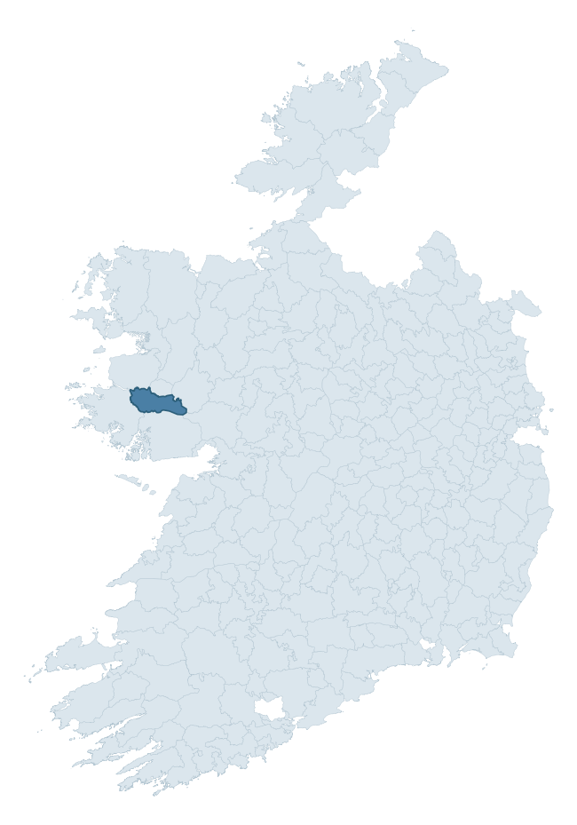
Where this barony sits in the Republic of Ireland
Geology and preservation
Bedrock geology shapes the landscape long before any settlement begins — controlling soil drainage, agricultural potential, the survival of upstanding monuments, and the preservation of buried archaeology. The figures below come from the Geological Survey Ireland 1:100,000 bedrock map.
The bedrock underlying Ross is predominantly schists (15% of the barony by area), with much of the rock dating to the Proterozoic period. Schist forms upland, often steep terrain with thin soils that limited agriculture but favoured the construction of stone-built monuments and field walls. Schist landscapes commonly carry megalithic monuments and prehistoric ritual sites. With 17 distinct rock types mapped, the barony sits in the top third of ROI baronies for geological diversity (98th percentile) — typically a sign of complex tectonic history or coastal mosaics of differing rock units.
Rock type composition
Largest mapped unit: Ballynakill Schist Formation (15% of the barony)
Placename evidence
Logainm records 8 heritage-diagnostic placenames for Ross, a modest sample drawn predominantly from the townland record. The dominant stratum is early christian ecclesiastical. The most frequent diagnostic roots are cill- (5) and ráth- (1). With a sample of this size the count should be treated as indicative rather than definitive.
Pre-Christian / Early Medieval Defensive
| Root | Count | Meaning |
|---|---|---|
| ráth- | 1 | earthen ringfort |
| caiseal- | 1 | stone ringfort |
Early Christian Ecclesiastical
| Root | Count | Meaning |
|---|---|---|
| cill- | 5 | church (early) |
| tobar- | 1 | holy well |
Other baronies in Galway
About this profile
Click any section below to expand.
What is a barony?
A barony is a historic administrative unit in Ireland, broadly equivalent to an English hundred. The 280 baronies used here are from the OSi 2019 National Statutory Boundaries (generalised 20m), covering the 26 counties of the Republic of Ireland. Baronies derive from the Norman period, were formalised in the 17th century, and have not been redrawn for statistical purposes. They vary enormously in area, from compact urban baronies in Dublin to vast upland baronies in Connacht, and should not be compared by raw site count without accounting for area differences.
What counts as a site?
This profile combines three distinct heritage registers, each with its own definition of what constitutes a recordable site:
- Archaeological sites (NMS). The National Monuments Service Sites and Monuments Record (SMR) catalogues every known archaeological monument or site of archaeological interest in the Republic, from prehistoric burial mounds and ringforts to medieval churches and post-medieval defensive works. Inclusion does not require legal protection — only that the site has been identified, surveyed, and assessed as having archaeological value. A separate subset of these sites lies within a recorded protection zone, which gives them statutory protection under the National Monuments Acts.
- Listed buildings (NIAH). The National Inventory of Architectural Heritage records buildings of architectural, historical, archaeological, artistic, cultural, scientific, social, or technical interest. Each surveyed structure is appraised on a five-tier scale: International, National, Regional, Local, and Record-Only. The NIAH appraisal is informational rather than strictly statutory, but it underpins local-authority Record of Protected Structures (RPS) listings.
- Heritage placenames (Logainm). Logainm is the authoritative database of Irish placenames maintained by the Placenames Branch. This profile applies a heritage-diagnostic classifier to the Irish-language form of each townland name, flagging roots that signal defensive sites (ráth-, lios-, dún-, caiseal-, cathair-), ecclesiastical foundations (cill-, teampall-, domhnach-, mainistir-), prehistoric burial-ritual features (tuaim-, carn-, leaba-), or Norse-contact settlement (gall-). Townlands without one of these diagnostic roots are not flagged here — they may still carry historical significance, but that significance is not encoded in the name itself.
Editorial principles
The narrative sections of this profile follow several explicit principles:
- Evidential. Every claim about this barony’s heritage character is anchored in the underlying register data. Where a site count, a placename count, or a percentile rank is cited, it is computed from the source datasets at export time, not estimated.
- Comparative. Counts and metrics are reported alongside their percentile rank against the other 279 ROI baronies. A barony with 50 ringforts in absolute terms could be unusually high or unusually low depending on its size and regional context; percentile ranking removes that ambiguity.
- Transparent on limits. Where a register has known coverage gaps, survey biases, or data-quality issues that affect this barony’s figures, the profile flags them rather than presenting the numbers as definitive.
- No interpretation beyond what the data supports. The narrative does not speculate about historical events, social dynamics, or cultural meaning beyond what the recorded heritage and placename evidence directly attests.
Data caveats and limits
- NMS Sites and Monuments Record is the product of survey campaigns conducted at different intensities across different counties and decades. Some baronies have been surveyed more thoroughly than others, and absolute counts should be read in that light. Sites destroyed by development before survey are typically not represented; sites in heavily forested or upland terrain are sometimes under-recorded.
- NIAH coverage is broadly complete for the Republic of Ireland but the survey was conducted on a rolling county-by-county basis, and the most recent appraisal date varies. Buildings demolished or substantially altered after their original survey may still appear in the register; conversely, recent buildings of merit may not yet have been appraised.
- Logainm classification applies a deliberately conservative pattern-matching approach to the Irish-language townland forms. The classifier prioritises true positives over recall: a townland may carry a heritage signal that the classifier doesn’t recognise, particularly where the diagnostic root has been heavily anglicised or where the townland name draws on a less common term. The 60,000+ townland records and ~9,800 classified placenames give a substantial signal at barony scale, but individual townland names should be checked against Logainm directly for definitive interpretation.
- Period attribution. The chronological distribution reflects only those NMS sites that carry a recognised period attribution in the source data. Sites listed as “Unknown” period are excluded from the dated subset.
- Boundary changes. Some baronies have undergone minor boundary adjustments since their 19th-century definition; the OSi 2019 generalised boundaries used here are the current statutory definition and may differ slightly from historical maps in border areas.
- Bedrock geology is mapped at 1:100,000 scale, which means local variation within a barony — small pockets of different rock type, mineral veins, alluvium overlying bedrock — is generalised. The dominant-system and rocktype figures are area-weighted, so a barony reading “70% Carboniferous limestone” may still contain small but archaeologically important pockets of older or younger rock. Around 3% of GSI polygons do not match the lexicon and contribute no rocktype or system attribution.
Data sources
- National Monuments Service — Sites and Monuments Record (SMR) https://data.gov.ie/dataset/national-monuments-service-archaeological-survey-of-ireland
- National Inventory of Architectural Heritage (NIAH) https://data.gov.ie/dataset/national-inventory-of-architectural-heritage-niah-national-dataset
- Logainm — Placenames Database of Ireland https://www.logainm.ie/
- Ordnance Survey Ireland — National Statutory Barony Boundaries 2019 https://data-osi.opendata.arcgis.com/
- EURODEM — European Digital Elevation Model https://www.mapsforeurope.org/datasets/euro-dem
- ESA WorldCover https://esa-worldcover.org/en
- Geological Survey Ireland — 1:100,000 Bedrock Geology https://www.gsi.ie/en-ie/data-and-maps/Pages/Bedrock.aspx
Explore more: Search any of the 280 ROI baronies, browse by historical province, or read the methodology and data sources for the full Republic of Ireland Heritage Tool.