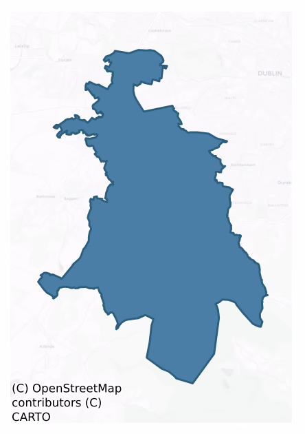
Uppercross is a barony of County Dublin, in the historical province of Leinster (Irish: An Chrois Uachtarach), covering 136 km² of land. The barony records 204 NMS archaeological sites and 337 NIAH listed buildings, placing it at around the 33rd percentile among 280 ROI baronies for sites per km². This means it is in the lower half of all baronies for sites per km². Dated archaeological evidence runs from the Mesolithic through to the Post Medieval, spanning 8 of 9 archaeological periods, placing the barony in the 83rd percentile among 280 ROI baronies for chronological depth. This means it is in the top fifth of all baronies for chronological depth. The largest dated subset of recorded sites dates to the Early Bronze Age. Logainm flags 23 placenames in the barony as carrying a recognised heritage root; the largest share — around 48% — are names associated with pre-christian defensive.

Heritage at a glance
Percentile rankings throughout this profile compare each barony only against the other 279 Republic of Ireland baronies.
The recorded heritage of Uppercross
The National Monuments Service Sites and Monuments Record (SMR) is the statutory inventory of archaeological sites for the Republic of Ireland, maintained by the Department of Tourism, Culture, Arts, Gaeltacht, Sport and Media. Sites recorded here include earthworks, ringforts, megalithic tombs, ecclesiastical remains, and post-medieval features; not every record is legally protected, but each is registered as a monument of archaeological interest.
The National Monuments Service records 204 archaeological sites in Uppercross, putting it at the 33rd percentile among 280 ROI baronies for sites per km². This means it is in the lower half of all baronies for sites per km². Protection coverage is near-universal — 194 sites (95%) fall within a recorded monument protection zone, indicating an extensively surveyed landscape. The record is dominated by defensive sites — ringforts, enclosures, hillforts, and stone forts (46 sites, 23% of the total), with ecclesiastical sites forming a substantial secondary presence (39 sites, 19%). The most diagnostically specific type is Church (12 records, 6% of the barony's NMS total) — compared to an ROI average of 4% across all baronies where this type occurs. Church is a building used for public Christian worship, of any date from c. 500 AD onwards. The broader 'Enclosure' classification — which catches unclassified ringforts and field enclosures — accounts for a further 18 records (9%) and reflects the difficulty of sub-classifying degraded earthworks from surface evidence alone. Across the barony's 136 km², this gives a recorded density of 1.49 sites per km².
Most common monument types
Hover or tap a monument type to see its definition.
| Type | Count |
|---|---|
| Enclosure a banked or ditched feature of uncertain type, used as a catch-all where the original function cannot be determined from surface evidence | 18 |
| Church a building used for public Christian worship, of any date from c. 500 AD onwards | 12 |
| Cairn – unclassified a stone mound that cannot be assigned to a specific cairn type | 12 |
| Graveyard a burial area associated with a church, in use from the medieval period onwards | 10 |
| Castle – tower house a fortified residential tower of four or five storeys, mostly built by lords in the 15th and 16th centuries and often within a defended bawn | 9 |
| Castle – unclassified a castle whose form cannot be precisely classified, dating somewhere between the late 12th and 16th centuries | 9 |
| Mound an artificial earthen elevation of unknown date and function that cannot be classified as another known monument type | 7 |
Chronological distribution
The dated archaeological record for Uppercross spans from the Mesolithic through to the Post Medieval, with activity attested across 8 of 9 archaeological periods. This is the 83rd percentile across ROI baronies for chronological depth — an above-average span. Every period from earliest to latest is represented in the record — an unbroken sequence of dated activity across the full chronological span. Activity concentrates most heavily in the Early Bronze Age (38 sites, 26% of dated material), with the Iron Age forming a secondary peak (31 sites, 21%). A further 55 recorded sites (27% of the overall NMS register for the barony) carry no period attribution — appearing as 'Unknown' in the bar chart below. This typically reflects either records that pre-date the standardised period vocabulary or sites awaiting specialist dating review, rather than a genuine absence of chronological evidence.
Sample of recorded monuments
Show 25 sample monuments (of 204 total)
A representative sample of 25 recorded monuments drawn from the barony’s 204 total NMS entries. Sites within a recorded monument protection zone and rarer site types are prioritised so the list shows a meaningful cross-section rather than only the most common type. Each entry shows the official Sites and Monuments Record reference number and the description published by the National Monuments Service.
Round tower
The round tower and the monastery of Clondalkin (Chluain Dolcáin/Dolcáin's Meadow) was described in the Urban Survey of Dublin (Bradley and King 1988, 215-24) as follows; 'The origins of the settlement of Clondalkin lie…
The round tower and the monastery of Clondalkin (Chluain Dolcáin/Dolcáin's Meadow) was described in the Urban Survey of Dublin (Bradley and King 1988, 215-24) as follows; 'The origins of the settlement of Clondalkin lie in the Early Christian period with the foundation of a monastery there in the seventh century by St Mochua (Cronan) (Gwynn and Hadcock 1970, 31). Abbots are first mentioned in the annals during the eighth century and it is recorded that the relics of Mochua were translated here in 789. The monastery was sufficiently important to be plundered by the Vikings in 833 and shortly afterwards Clondalkin became a base for Viking activities in the area. Little is known of this period of Clondalkin's history, which, is potentially significant archaeologically because it appears to be one of the few recorded Viking rural settlement sites. A fort was established by Olaf the White, the first Norwegian king of Dublin. It is recorded only once in the annals, when it was attacked and captured in 867 by two Leinster chieftains: "Amlaib's fort at Cluain Dolcain [Clondalkin] was burned by Gaithine's son and Mael Ciarain son of Ronan, and the aforesaid commanders caused a slaughter of a hundred of the leaders of the foreigners in the vicinity of Cluain Dolcain on the same day" (MacNiocaill 1983, 323). The implication of this entry is that there was also Viking settlement in the vicinity of Clondalkin but unfortunately the exact whereabouts of the fort itself is unknown. The Vi…
Children's burial ground
According to Ua O'Broin (1944, 199) there was a burial place for unbaptised children located near St. Brigid's well which comprised a mound of earth enclosed by a ditch.
Compiled by Geraldine Stout
Gateway
According to Ua Broin (1944, 200) there was an arched gateway which incorporated a date stone of 1577 that lead off the old Belgard Road into Newlands House. This gateway was removed when the new Belgard Road was…
According to Ua Broin (1944, 200) there was an arched gateway which incorporated a date stone of 1577 that lead off the old Belgard Road into Newlands House. This gateway was removed when the new Belgard Road was constructed in 1983.
Compiled by Geraldine Stout
House – fortified house
The surviving architectural remains of the manor form a roughly rectangular courtyard with out-buildings attached to and extending E and W of the original 17th century manor house. The N gable wall and SW corner is all…
The surviving architectural remains of the manor form a roughly rectangular courtyard with out-buildings attached to and extending E and W of the original 17th century manor house. The N gable wall and SW corner is all that survives of the manor house. It is built of lightly bonded masonry with block and dot decoration on the quoins indicating a 17th century date. The N wall rises to two storeys with splayed embrasure on the ground floor and a fireplace on first floor (est. dims. c. L 16m, Wth 8.20m). A rectangular vaulted chamber is attached to the N end (int. dims. L 9.50m, Wth 3.70m). Window in N wall (Healy 1977, 1-5; St John Joyce 1912, 217-219; Stout 1982, 217, Stout 1998, 145-154).
Further excavations in 1997 uncovered the eastern section of a substantial stone building, of which a small section (west) survives above ground in derelict form. The eastern gable end of the structure had been removed by the sewer-pipe trench (at 62.09m OD). Excavation directly east of the standing section revealed sub-surface remains of the central portion of the structure, including foundation walls, a partition wall, internal post-holes and a series of internal cobbled floors and drainage features. A mixture of medieval and post-medieval finds were recovered from the cobbled floors and associated wall foundations. The remains of a late outhouse structure were recorded and a section of stone wall was uncovered within the cobbled surface 1.5m south of the outhouse. This wall survive…
Barrow – stepped barrow
This two-tiered earthen mound is located in a field of pasture NW of a 17th century manor house (DU021-015001-) and within a ceremonial enclosure (DU021-015006-). The first stage of the earthwork is a raised,…
This two-tiered earthen mound is located in a field of pasture NW of a 17th century manor house (DU021-015001-) and within a ceremonial enclosure (DU021-015006-). The first stage of the earthwork is a raised, steep-sided platform (diam.42m; H 2.5m) with a wide berm around the upper edge (Wth 3.5m). The second stage is a smaller earthen mound (diam. c. 20m; H 2.5m). A circular stone wall of limestone masonry runs around the top of the upper mound (diam. 10m). Inside of this is a square turret with a plain doorway and window with chamfered brick corners. The upper stage of the earthwork had been landscaped to insert an external stone stairs on the SW side. Beranger's drawing of 1767 shows this as a two-storied turret. This 'Sham Ruin' was probably erected on the earlier mound in the 17th century as part of the landscaping of the manor (McDix 1898, 40, 19; Handcock 1899, 6; Ball 1906, 116, Stout 1998, 145-154).
Compiled by Geraldine Stout
Designed landscape – belvedere
On the summit of a stepped barrow is a circular masonry enclosure c. 10m in diameter on top of which is a small turret. This contains a doorway and three windows. Beranger's drawing of 1767 shows this as a two storied…
On the summit of a stepped barrow is a circular masonry enclosure c. 10m in diameter on top of which is a small turret. This contains a doorway and three windows. Beranger's drawing of 1767 shows this as a two storied turret. This is an Eighteenth-century folly.
Compiled by Geraldine Stout
Ceremonial enclosure
An aerial photograph (FSI 2 262/1) taken in 1971 shows cropmark evidence for a large oval enclosure (165m E-W; 102m N-S) confined to a field W of the ruinous buildings at Ballymount Great. The E end of the enclosure has…
An aerial photograph (FSI 2 262/1) taken in 1971 shows cropmark evidence for a large oval enclosure (165m E-W; 102m N-S) confined to a field W of the ruinous buildings at Ballymount Great. The E end of the enclosure has been disturbed by a track which crosses the site on a N-S axis. Located eccentrically on a slight prominence in this enclosure is a stepped barrow (DU021-015003-). Excavations in 1982, prior to roadway construction revealed one inner fosse (dims. Wth 4.5m; D 1.7m) and a denuded external earthen bank (Wth 6.8m; H 0.4m). Finds at base of fosse fill included animal bones and iron objects namely a socketed tool, a tanged knife and iron slag. A horse-skull lay in a primary position in the fosse indicating a possible ritual deposit. Final silting of the fosse took place in the 9th century AD (Stout 1998, 145-154). Further investigations were undertaken in 1997 to examine the eastern part of the enclosure threatened by the proposed Luas Line. The only finds recovered were animal bones and two sherds of Medieval pottery. Excavation of the main enclosure ditch in 2002 demonstrated the existence of a medieval re-cutting of this feature and possible evidence for an entrance (O Néill 2004, 125).
Compiled by Geraldine Stout
Tomb – unclassified (present location)
One of a number of 17th century tombs in the churchyard (DU021-037004-). FitzGerald states that the central passage up the old church was flagged with large tombstones, some of which, at the time of his writing, lay not…
One of a number of 17th century tombs in the churchyard (DU021-037004-). FitzGerald states that the central passage up the old church was flagged with large tombstones, some of which, at the time of his writing, lay not far from the gateway of the churchyard (Fitzgerald 1906-08, 31). He states that 'the tomb of Colonel John Talbot, of Belgard is said to have been placed at the foot of the communion table' (ibid, 31-2). O'Curry states that it was moved from its position at the foot of the high alter in the church when the church was transferred from the Catholics to the Protestants (O'Curry 1837, 28). This was to be found on a flat fractured slab, sunk into the ground near the entrance gate, accompanied by the armorial bearings of the Talbots and their motto (FitzGerald 1906-08, 32).
Flat cemetery
These burials were first uncovered in 1892 during the quarrying of a sand and gravel ridge (NMI 1892:48). The remains comprised a burial with a bowl food vessel and an uncontexted vase food vessel. In 1898 there were…
These burials were first uncovered in 1892 during the quarrying of a sand and gravel ridge (NMI 1892:48). The remains comprised a burial with a bowl food vessel and an uncontexted vase food vessel. In 1898 there were further discoveries of two cists with two pit burials and two other possible pit burials (Plunkett 1898-190, 388). One contained an urn, the other a food vessel/urn (Waddell 1970, 116; 1990, 83). There is a development on the site.
Compiled by Geraldine Stout
Watercourse
Named 'City Watercourse' on the 1837 OS 6-inch map. It is shown on the Down Survey (1655-6) maps as the 'water that supplieth Dublin'. This section of the medieval watercourse runs from Kimmage crossroads to the…
Named 'City Watercourse' on the 1837 OS 6-inch map. It is shown on the Down Survey (1655-6) maps as the 'water that supplieth Dublin'. This section of the medieval watercourse runs from Kimmage crossroads to the 'Tongue' at Kimmage. Half way along the watercourse is joined by a stream called the Poddle and they flow as one stream for a short distance, the waters separating at the Tongue (Joyce 1912, 452-453; Berry 1891, 557-73).
Compiled by Geraldine Stout
Earthwork
The OS Letters describe a 'wide and deep fosse' which enclosed Kilnamanagh castle and a drawbridge (ed. O'Flanagan ed. 1927, 34(63)).
Compiled by Geraldine Stout
Bridge
The Oldbawn bridge, built in 1840 succeeded one of three arches which previously spanned the river at that place (Hegarty 1939, 59-72).
Ringfort – cashel
Situated on the summit of a W-facing slope overlooking Glenasmole with magnificent views of the coast and surrounding mountain peaks. A ringfort comprises a hollowed, roughly circular area (int. dims.9m E-W; 14m N-S)…
Situated on the summit of a W-facing slope overlooking Glenasmole with magnificent views of the coast and surrounding mountain peaks. A ringfort comprises a hollowed, roughly circular area (int. dims.9m E-W; 14m N-S) which is defined by a drystone wall (Wth 3.2m; H 0.8m). The wall has a boulder core and traces of an inner and outer stone facing. The N side of the site is truncated by an avenue which itself is defined by a bank, ledge and scarp in the slope. (Healy 1975, 1-19).
Compiled by: Geraldine Stout and Padraig Clancy
Uploaded on: 7 July 2018
Megalithic structure
Situated to SE of the summit of Seahan Mountain from which there are extensive views of the Liffey valley, and the passage tombs at Mountpelier. A megalithic structure is located SE of the main cairn (DU024:047001-)…
Situated to SE of the summit of Seahan Mountain from which there are extensive views of the Liffey valley, and the passage tombs at Mountpelier. A megalithic structure is located SE of the main cairn (DU024:047001-) which crowns the summit. It is largely peat-covered and comprises a square chamber (1.2m by 1.2m) with some traces of kerbstones to the NW (Redmond and Mac Aonghusa 1994, 36).
Compiled by: Geraldine Stout and Padraig Clancy
Revised upload on: 7 July 2018
Watchtower
Situated in a graveyard (DU025-003005-) on a steep grass-covered knoll, off the Pine Forest Road. A cemetery watchtower built to prevent the robbery of freshly dug graves which consists of a two storey high cylindrical…
Situated in a graveyard (DU025-003005-) on a steep grass-covered knoll, off the Pine Forest Road. A cemetery watchtower built to prevent the robbery of freshly dug graves which consists of a two storey high cylindrical tower (ext. diam. 3.2m), with a parapet level marked by an offset. It is built of roughly coursed granite masonry. There is a lintelled doorway now blocked in the N. The interior is lit by narrow, square-headed opes. Within the graveyard are the remains of Cruagh church (DU023-003001-) and a roughly square-shaped granite font (DU025-003002-). In the 19th century a Rathdown type graveslab (DU025-003004-) showing concentric circles, was discovered here but it has since disappeared (O'Reilly 1901, 184-155; Crawford 1913, 167; Ó hÉailidhe 1957, 86).
Compiled by: Geraldine Stout and Padraig Clancy
Revised upload on: 7 July 2018
Megalithic tomb – unclassified
Situated on the lower N slopes of Tibradden Mountain. A megalithic tomb shown on the 1906 revision of OS map as a small hachured mound bounded on the W and S by a hachured embankment. Noted on the Cassini 6" edition as…
Situated on the lower N slopes of Tibradden Mountain. A megalithic tomb shown on the 1906 revision of OS map as a small hachured mound bounded on the W and S by a hachured embankment. Noted on the Cassini 6" edition as 'Dolmen (site of)'. Removed in the course of gravel quarrying. Not visible at ground level.
Compiled by: Geraldine Stout and Padraig Clancy
Revised upload on: 8 July 2018
Megalithic tomb – wedge tomb
Situated in a state forestry plantation on a slight summit overlooking the Glen between Cruagh and Mountpelier. A megalithic tomb consisting of an irregular low mound (Wth 7m) which contains a number of protruding…
Situated in a state forestry plantation on a slight summit overlooking the Glen between Cruagh and Mountpelier. A megalithic tomb consisting of an irregular low mound (Wth 7m) which contains a number of protruding upright slabs (Ó hÉailidhe 1978, 101-3). The chamber extends E-W, with a W-facing façade and entrance (L 6m; Wth 6m). It is defined by sidestones and one endstone. Running parallel to the sides are remains of a double revetment wall of upright slabs. There are traces of kerbstones in the NW. Both the cairn material and roofing slabs have been removed.
Compiled by: Geraldine Stout and Padraig Clancy
Revised upload on: 8 July 2018
Cross-inscribed stone
Situated to the E of the R115 and a small gravel pit on Glassmucky Mountain. A roadside granite boulder set on its long axis (dims. L 1.10m, Wth 0.62m, N-S, H 0.42m) with a cross inscribed on its exposed face. This…
Situated to the E of the R115 and a small gravel pit on Glassmucky Mountain. A roadside granite boulder set on its long axis (dims. L 1.10m, Wth 0.62m, N-S, H 0.42m) with a cross inscribed on its exposed face. This cross has expanded terminals (H 0.40m, Wth 0.35m, Healy 1961, 125, Price 1959, 165). There is a local tradition that it marks the spot where the body of a chimney sweep was found who had been caught in a snowstorm and had frozen to death. It is known as 'Sweep's Cross' (Swords, K. ed.2009, 109).
Compiled by: Geraldine Stout and Padraig Clancy
Uploaded on: 28 July 2018
Bullaun stone
Situated on the SE slope of Glassamucky Mountain. This is a large earthfast boulder marking the corner of a townland and county boundary (dims. L 3.2m; Wth 1.65m). There are two hollows in the SE end of the boulder…
Situated on the SE slope of Glassamucky Mountain. This is a large earthfast boulder marking the corner of a townland and county boundary (dims. L 3.2m; Wth 1.65m). There are two hollows in the SE end of the boulder (Dims. Of hollows L 0.55m; Wth 0.43m; 0.1m; D. 0.50; Wth 0.35m, respectively). There is another circular hollow on the N face (diam. 0.4m; D 0.14m).
Compiled by: Geraldine Stout and Padraig Clancy
Uploaded on: 28 July 2018
Pit-burial
Situated on a N facing slope with extensive view to the E, N and W. A pit burial containing a cinerary urn inverted over a cremation (NMI 1978:342-345). In 1978 two burials were found during removal of topsoil from a…
Situated on a N facing slope with extensive view to the E, N and W. A pit burial containing a cinerary urn inverted over a cremation (NMI 1978:342-345). In 1978 two burials were found during removal of topsoil from a quarry (Kelly 1987-8, 73), the second burial came from a cist (DU025-057001-).
Compiled by: Geraldine Stout and Padraig Clancy
Revised upload on: 28 July 2018
Weir – regulating
A stone built weir, built to resist floods was erected at the head of the watercourse at Balrothery near the gravel pits. The Dodder River was diverted at this stone weir and an artificial channel was constructed which…
A stone built weir, built to resist floods was erected at the head of the watercourse at Balrothery near the gravel pits. The Dodder River was diverted at this stone weir and an artificial channel was constructed which carried the required water eastward to join the river Poddle. This was removed during road construction (Keeley unpub).
Kiln – lime
Archaeological investigations in 1997 immediately below the foundation layer for the earliest cobbled floor of one of the outbuildings at Ballymount manor uncovered a limekiln. In profile the kiln is 1.2m wide and 0.71m…
Archaeological investigations in 1997 immediately below the foundation layer for the earliest cobbled floor of one of the outbuildings at Ballymount manor uncovered a limekiln. In profile the kiln is 1.2m wide and 0.71m deep, consisting of a flat base (1m wide) of limestone slabs (top 62.32m OD) with vertical walls of irregularly shaped stones 0.6m high (south) and 0.5m high (north). The kiln is filled by three deposits: a basal layer of white lime mortar, at most 0.13m thick, an intermediate level of mixed brown soil with orange clay flecks, at most 0.36m deep, and an upper boulder infill, at most 0.22m deep. Three sherds of Dublin-type ware and one of Leinster cooking ware were recovered from the fills indicating a medieval date (Conway, 1998, 22-23).
Compiled by Geraldine Stout
Tomb – chest tomb
One of a number of seventeenth century tombs in the churchyard (DU021-037004-). This altar tomb was located near “the lossit” (font, DU021-037009-) (Fitzgerald 1906-8, 3). It commemorates members of the Reilly family…
One of a number of seventeenth century tombs in the churchyard (DU021-037004-). This altar tomb was located near “the lossit” (font, DU021-037009-) (Fitzgerald 1906-8, 3). It commemorates members of the Reilly family who died in the late 17th century (Fitzgerald 1906-8, 33).
Compiled by: Geraldine Stout
Date of upload: 18 January 2012
Tomb – unclassified
One of three 17th century tombs in the churchyard (DU021-037004-).
Inscribed'Murce. Walsh died 6th April 1685' (Price, L. (ed) 1942, 39-41).
Compiled by Geraldine Stout
Enclosure
Situated in rich pastureland on a N facing slope. A rectangular enclosure defined by a bank (int. dims. L 12.72m; Wth 9.12m; bank Wth 3.40m; H 0.7m) surveyed by the field survey unit of the Archaeological Society U. C.…
Situated in rich pastureland on a N facing slope. A rectangular enclosure defined by a bank (int. dims. L 12.72m; Wth 9.12m; bank Wth 3.40m; H 0.7m) surveyed by the field survey unit of the Archaeological Society U. C. D. in 1942. There were two large stones in the NE and SE corners. There are no visible remains above ground (Healy 1975, 1-19).
Compiled by: Geraldine Stout and Padraig Clancy
Revised upload on: 6 July 2018
Listed buildings
The National Inventory of Architectural Heritage (NIAH) is a state survey appraising buildings of architectural, historical, archaeological, artistic, cultural, scientific, social, or technical interest. Each surveyed structure receives a rating from International (the highest, for buildings of European importance) through National, Regional, Local, and Record-Only.
The NIAH records 337 listed buildings in Uppercross, the 90th percentile across ROI baronies for listed-building density. The highest-graded structures include 4 of National significance. The Republic holds 937 National-graded buildings in total, so this barony accounts for around 0% of the national total. Construction dates concentrate most heavily in the Victorian (1830-1900) period. The most-recorded building type is house (115 examples, 34% of the listed stock).
Terrain and environment
Mean elevation across the barony is 228m — the 98th percentile among 280 ROI baronies for elevation. This means it is in the top tenth of all baronies for elevation. This is a relatively elevated landscape by ROI standards. Elevation matters for heritage because higher-altitude baronies typically favour defensive monuments — ringforts and hilltop forts placed on prominent ground — while lowland baronies are more likely to carry the dense settlement and church networks of intensive agricultural landscapes. The barony reaches 748m at its highest point — a vertical span of more than 520m within its boundary, indicating significant topographic diversity. Mean slope is 6.2° — the 87th percentile among 280 ROI baronies for slope. This means it is in the top fifth of all baronies for slope. This is consistently steep terrain by ROI standards, the kind of landscape that tends to preserve upstanding archaeological features well. Slope is a key control on both land use and archaeological preservation: steep ground resists ploughing and tends to preserve earthworks intact, while gentle slopes favour intensive cultivation that damages or destroys surface archaeology over time. Localised maximum slopes reach 17°, typical of stream-cut valleys, escarpments, or coastal bluffs within the wider landscape. The Topographic Wetness Index averages 9.8, the 16th percentile among 280 ROI baronies for wetness. This means it is in the bottom fifth of all baronies for wetness. This is well-drained ground by ROI standards — typical of upland or steeply-sloping country that sheds water rapidly. Drainage matters for heritage because poorly-drained ground preserves organic archaeology (wooden trackways, leather, textiles, and on rare occasions human remains) far better than free-draining soil; well-drained ground favours arable use but destroys organic material rapidly. Urban land covers 23% of the barony (the 98th percentile among 280 ROI baronies for urban cover. This means it is in the top tenth of all baronies for urban cover). Heavy urban coverage compresses heritage analysis: many archaeological features have been buried or destroyed by development, but the surviving record is concentrated in protected city-centre cores, and the NIAH listed-buildings count is typically high. The land-cover mosaic combines improved grassland (54%), urban land (23%), and woodland (22%), giving a mixed agricultural and semi-natural landscape. In overall character, this is an upland landscape of steep, elevated terrain, with land use dominated by improved grassland.
Terrain measurements
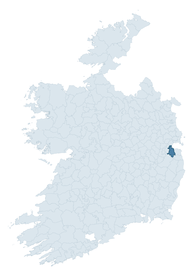
Where this barony sits in the Republic of Ireland
Geology and preservation
Bedrock geology shapes the landscape long before any settlement begins — controlling soil drainage, agricultural potential, the survival of upstanding monuments, and the preservation of buried archaeology. The figures below come from the Geological Survey Ireland 1:100,000 bedrock map.
The bedrock underlying Uppercross is predominantly limestone (40% of the barony by area), with much of the rock dating to the Carboniferous period. Limestone is the most heritage-rich bedrock in Ireland. It supports fertile, well-drained soils that favoured dense Early Medieval settlement and Norman manorial agriculture, and it weathers into karst features — sinkholes, caves, swallow holes, and souterrains — that frequently carry archaeology. Where peat overlies limestone, organic preservation can be exceptional. A substantial secondary geology of granite (28%) and greywack, siltstone, slate (16%) adds further variety to the underlying landscape. The single largest mapped unit is the Lucan Formation (40% of the barony's bedrock).
Rock type composition
Largest mapped unit: Lucan Formation (40% of the barony)
Placename evidence
Logainm records 23 heritage-diagnostic placenames for Uppercross, drawn from townland and civil-parish names across the barony. The dominant stratum is pre-Christian and Early Medieval defensive — ráth-, lios-, dún-, and caiseal-prefixed names that mark Iron Age and early historic settlement. The leading diagnostic roots are ráth- (11 — earthen ringfort), cill- (8 — church), and carn- (2 — cairn). This is below the ROI average of 30.7 heritage placenames per barony, suggesting either lighter survey coverage or a townland-naming tradition that draws more on generic landscape vocabulary. The presence of multiple heritage strata side by side indicates layered occupation of the landscape across successive prehistoric and historic periods. Logainm records 159 placenames for Uppercross (predominantly townland names). Of these, 23 (14%) carry one of the diagnostic Gaelic roots tracked above; the remainder draw on more generic landscape vocabulary that does not encode a heritage period.
Pre-Christian / Early Medieval Defensive
| Root | Count | Meaning |
|---|---|---|
| ráth- | 11 | earthen ringfort |
Early Christian Ecclesiastical
| Root | Count | Meaning |
|---|---|---|
| cill- | 8 | church (early) |
| teampall- | 1 | church (later medieval) |
| tobar- | 1 | holy well |
Burial, Ritual, and Norse-Contact
| Root | Count | Meaning |
|---|---|---|
| carn- | 2 | cairn |
| gall- | 1 | foreigner — Norse settlement marker |
Other baronies in Dublin
About this profile
Click any section below to expand.
What is a barony?
A barony is a historic administrative unit in Ireland, broadly equivalent to an English hundred. The 280 baronies used here are from the OSi 2019 National Statutory Boundaries (generalised 20m), covering the 26 counties of the Republic of Ireland. Baronies derive from the Norman period, were formalised in the 17th century, and have not been redrawn for statistical purposes. They vary enormously in area, from compact urban baronies in Dublin to vast upland baronies in Connacht, and should not be compared by raw site count without accounting for area differences.
What counts as a site?
This profile combines three distinct heritage registers, each with its own definition of what constitutes a recordable site:
- Archaeological sites (NMS). The National Monuments Service Sites and Monuments Record (SMR) catalogues every known archaeological monument or site of archaeological interest in the Republic, from prehistoric burial mounds and ringforts to medieval churches and post-medieval defensive works. Inclusion does not require legal protection — only that the site has been identified, surveyed, and assessed as having archaeological value. A separate subset of these sites lies within a recorded protection zone, which gives them statutory protection under the National Monuments Acts.
- Listed buildings (NIAH). The National Inventory of Architectural Heritage records buildings of architectural, historical, archaeological, artistic, cultural, scientific, social, or technical interest. Each surveyed structure is appraised on a five-tier scale: International, National, Regional, Local, and Record-Only. The NIAH appraisal is informational rather than strictly statutory, but it underpins local-authority Record of Protected Structures (RPS) listings.
- Heritage placenames (Logainm). Logainm is the authoritative database of Irish placenames maintained by the Placenames Branch. This profile applies a heritage-diagnostic classifier to the Irish-language form of each townland name, flagging roots that signal defensive sites (ráth-, lios-, dún-, caiseal-, cathair-), ecclesiastical foundations (cill-, teampall-, domhnach-, mainistir-), prehistoric burial-ritual features (tuaim-, carn-, leaba-), or Norse-contact settlement (gall-). Townlands without one of these diagnostic roots are not flagged here — they may still carry historical significance, but that significance is not encoded in the name itself.
Editorial principles
The narrative sections of this profile follow several explicit principles:
- Evidential. Every claim about this barony’s heritage character is anchored in the underlying register data. Where a site count, a placename count, or a percentile rank is cited, it is computed from the source datasets at export time, not estimated.
- Comparative. Counts and metrics are reported alongside their percentile rank against the other 279 ROI baronies. A barony with 50 ringforts in absolute terms could be unusually high or unusually low depending on its size and regional context; percentile ranking removes that ambiguity.
- Transparent on limits. Where a register has known coverage gaps, survey biases, or data-quality issues that affect this barony’s figures, the profile flags them rather than presenting the numbers as definitive.
- No interpretation beyond what the data supports. The narrative does not speculate about historical events, social dynamics, or cultural meaning beyond what the recorded heritage and placename evidence directly attests.
Data caveats and limits
- NMS Sites and Monuments Record is the product of survey campaigns conducted at different intensities across different counties and decades. Some baronies have been surveyed more thoroughly than others, and absolute counts should be read in that light. Sites destroyed by development before survey are typically not represented; sites in heavily forested or upland terrain are sometimes under-recorded.
- NIAH coverage is broadly complete for the Republic of Ireland but the survey was conducted on a rolling county-by-county basis, and the most recent appraisal date varies. Buildings demolished or substantially altered after their original survey may still appear in the register; conversely, recent buildings of merit may not yet have been appraised.
- Logainm classification applies a deliberately conservative pattern-matching approach to the Irish-language townland forms. The classifier prioritises true positives over recall: a townland may carry a heritage signal that the classifier doesn’t recognise, particularly where the diagnostic root has been heavily anglicised or where the townland name draws on a less common term. The 60,000+ townland records and ~9,800 classified placenames give a substantial signal at barony scale, but individual townland names should be checked against Logainm directly for definitive interpretation.
- Period attribution. The chronological distribution reflects only those NMS sites that carry a recognised period attribution in the source data. Sites listed as “Unknown” period are excluded from the dated subset.
- Boundary changes. Some baronies have undergone minor boundary adjustments since their 19th-century definition; the OSi 2019 generalised boundaries used here are the current statutory definition and may differ slightly from historical maps in border areas.
- Bedrock geology is mapped at 1:100,000 scale, which means local variation within a barony — small pockets of different rock type, mineral veins, alluvium overlying bedrock — is generalised. The dominant-system and rocktype figures are area-weighted, so a barony reading “70% Carboniferous limestone” may still contain small but archaeologically important pockets of older or younger rock. Around 3% of GSI polygons do not match the lexicon and contribute no rocktype or system attribution.
Data sources
- National Monuments Service — Sites and Monuments Record (SMR) https://data.gov.ie/dataset/national-monuments-service-archaeological-survey-of-ireland
- National Inventory of Architectural Heritage (NIAH) https://data.gov.ie/dataset/national-inventory-of-architectural-heritage-niah-national-dataset
- Logainm — Placenames Database of Ireland https://www.logainm.ie/
- Ordnance Survey Ireland — National Statutory Barony Boundaries 2019 https://data-osi.opendata.arcgis.com/
- EURODEM — European Digital Elevation Model https://www.mapsforeurope.org/datasets/euro-dem
- ESA WorldCover https://esa-worldcover.org/en
- Geological Survey Ireland — 1:100,000 Bedrock Geology https://www.gsi.ie/en-ie/data-and-maps/Pages/Bedrock.aspx
Explore more: Search any of the 280 ROI baronies, browse by historical province, or read the methodology and data sources for the full Republic of Ireland Heritage Tool.