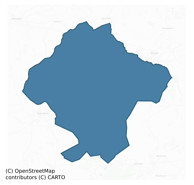
Carbury is a barony of County Kildare, in the historical province of Leinster (Irish: Cairbre), covering 195 km² of land. The barony records 177 NMS archaeological sites and 54 NIAH listed buildings, placing it at around the 10th percentile among 280 ROI baronies for sites per km². This means it is in the bottom fifth of all baronies for sites per km². Dated archaeological evidence runs from the Mesolithic through to the Modern, spanning 9 of 9 archaeological periods, placing the barony in the 95th percentile among 280 ROI baronies for chronological depth. This means it is in the top tenth of all baronies for chronological depth. The largest dated subset of recorded sites dates to the Early Medieval.

Heritage at a glance
Percentile rankings throughout this profile compare each barony only against the other 279 Republic of Ireland baronies.
The recorded heritage of Carbury
The National Monuments Service Sites and Monuments Record (SMR) is the statutory inventory of archaeological sites for the Republic of Ireland, maintained by the Department of Tourism, Culture, Arts, Gaeltacht, Sport and Media. Sites recorded here include earthworks, ringforts, megalithic tombs, ecclesiastical remains, and post-medieval features; not every record is legally protected, but each is registered as a monument of archaeological interest.
The National Monuments Service records 177 archaeological sites in Carbury, putting it at the 10th percentile among 280 ROI baronies for sites per km². This means it is in the bottom fifth of all baronies for sites per km². A sparse recorded total of this kind in Ireland often reflects survey priority rather than genuine absence of past activity. Protection coverage is near-universal — 164 sites (93%) fall within a recorded monument protection zone, indicating an extensively surveyed landscape. The record is dominated by defensive sites — ringforts, enclosures, hillforts, and stone forts (64 sites, 36% of the total), with ecclesiastical sites forming a substantial secondary presence (44 sites, 25%). The most diagnostically specific type is Moated site (13 records, 7% of the barony's NMS total) — compared to an ROI average of 2% across all baronies where this type occurs. The broader 'Enclosure' classification — which catches unclassified ringforts and field enclosures — accounts for a further 17 records (10%) and reflects the difficulty of sub-classifying degraded earthworks from surface evidence alone. Across the barony's 195 km², this gives a recorded density of 0.91 sites per km².
Most common monument types
Hover or tap a monument type to see its definition.
| Type | Count |
|---|---|
| Enclosure a banked or ditched feature of uncertain type, used as a catch-all where the original function cannot be determined from surface evidence | 17 |
| Moated site | 13 |
| Church a building used for public Christian worship, of any date from c. 500 AD onwards | 12 |
| Graveyard a burial area associated with a church, in use from the medieval period onwards | 12 |
| Ringfort – rath an earthen ringfort enclosed by a bank and external ditch — the most common Early Medieval farmstead, broadly dated 500–1000 AD | 10 |
| Ritual site – holy well a well or spring traditionally associated with a saint, often credited with healing properties; many trace earlier ritual origins but devotion is documented from the medieval period onwards | 8 |
| Castle – unclassified a castle whose form cannot be precisely classified, dating somewhere between the late 12th and 16th centuries | 6 |
| Ringfort – unclassified a circular Early Medieval settlement enclosure where surviving evidence does not allow distinction between earthen and stone forms | 6 |
Chronological distribution
The dated archaeological record for Carbury spans from the Mesolithic through to the Modern, with activity attested across 9 of 9 archaeological periods. This places Carbury in the top 5% of ROI baronies for chronological depth — few baronies record evidence across as many distinct archaeological periods. Every period from earliest to latest is represented in the record — an unbroken sequence of dated activity across the full chronological span. Activity concentrates most heavily in the Early Medieval (697 sites, 50% of dated material), with the Iron Age forming a secondary peak (317 sites, 23%). A further 352 recorded sites (20% of the overall NMS register for the barony) carry no period attribution — appearing as 'Unknown' in the bar chart below. This typically reflects either records that pre-date the standardised period vocabulary or sites awaiting specialist dating review, rather than a genuine absence of chronological evidence.
Sample of recorded monuments
Show 25 sample monuments (of 177 total)
A representative sample of 25 recorded monuments drawn from the barony’s 177 total NMS entries. Sites within a recorded monument protection zone and rarer site types are prioritised so the list shows a meaningful cross-section rather than only the most common type. Each entry shows the official Sites and Monuments Record reference number and the description published by the National Monuments Service.
Castle – hall-house
Prominently sited on the upper, S-facing slope of Carrick Hill. A medieval church (KD002-010002-) and graveyard (KD002-010003-) stand 40m to SE. The monument comprises the poorly preserved remains of a possible…
Prominently sited on the upper, S-facing slope of Carrick Hill. A medieval church (KD002-010002-) and graveyard (KD002-010003-) stand 40m to SE. The monument comprises the poorly preserved remains of a possible late-13th/14th-century hall-house with a later tower attached at SE. The remains consist of the short, conjoined portions of the NE wall (int. L 6.8m; T 1.3m) and SE wall (int. L 3.3m; T 1.7m) of a three-story hall-house (the upper story a later addition) built of unbattered, randomly coursed, rounded granite blocks, on a plinth visible at the NW end of the NE wall (traceable L 1.5m; projects 0.3m NE), and orientated on a NW-SE axis; with a later, four- story rectangular tower (int.dims. L 8.2m NE-SW; Wth 3.2m NW-SE; wall T 1.5m) abutting at SE and built of more regularly coursed, rounded granite blocks with a substantial base-batter on its NE ,SW and SW walls. A low, grassed-over, almost square platform of collapsed rubble (dims.L 12.5m NE-SW; Wth 11m NW-SE; H 0.6m at SE- 1.2m at NW) extends NW from the surviving hall-house walls and may overlie original foundation course walling. The ground floor of the hall-house was lit by a loop in the NE wall and by a double-splayed loop in the SE wall which looks into the adjoining tower. The hall-house was entered at first- floor level through a doorway near the SE end of the NE wall. The doorway was subsequently altered; its top and NW-side were infilled to reduce its height and width and its external jambs and sill-stone a…
Stone head
Built into the W wall of the courtyard at Metcalfe Park house. A square stone (dims. c. 0.2m; c. 0.2m) carrying a face carved in low relief showing the eyes with lids and pupils, the lips placed off-centre below a…
Built into the W wall of the courtyard at Metcalfe Park house. A square stone (dims. c. 0.2m; c. 0.2m) carrying a face carved in low relief showing the eyes with lids and pupils, the lips placed off-centre below a broad, flared nose, and with 'crew-cut' style hair in pocked relief. Appears to be in a secondary location. Its original location (designated KD000-001—-) is unknown.
Compiled by: Gearóid Conroy
Date of upload: 10 June 2011
Habitation site
Two saddle-querns and a sherd of medieval pottery were found in a field near a stream on the E edge of the Bog of Allen (SMR file), and suggest the possible existence of a habitation site. The 1st ed. (1838) of the OS…
Two saddle-querns and a sherd of medieval pottery were found in a field near a stream on the E edge of the Bog of Allen (SMR file), and suggest the possible existence of a habitation site. The 1st ed. (1838) of the OS 6-inch map shows a rectangular building (est. dims. L c. 20m NNW-SSE; Wth c. 10m) immediately to the W, of which there is no visible surface trace. A rath (KD004-011—-) lies c. 250m to the SW.
Compiled by: Gearóid Conroy
Date of upload: 10 June 2011
Crannog
In a partially wooded area in open, improved pasture, at the confluence of a small NE-flowing stream with the NW-flowing River Blackwater. Described by O'Neill (1973-4, 250) as a crannog (dims. L c. 100m N-S; Wth c. 80m…
In a partially wooded area in open, improved pasture, at the confluence of a small NE-flowing stream with the NW-flowing River Blackwater. Described by O'Neill (1973-4, 250) as a crannog (dims. L c. 100m N-S; Wth c. 80m E-W) composed of hazel brush, stone and worked timbers, divided by the river and stream, both of which were drained in 1973, when the dredged material was deposited on portion of the site (dims. L c. 60m; Wth c. 15m; H c. 2m). This spoil contained human and animal bones, a perforated antler tine, iron slag and some timbers, all of which were collected and deposited in the National Museum of Ireland. The main drainage embankment is along the E side of the Blackwater and the river flows through a deep, narrow, V-shaped cut with nothing archaeological visible along the banks. A possible trackway (KD004-014001-) approaches the site from the W.
Compiled by: Gearóid Conroy
Date of upload: 10 June 2011
Castle – Anglo-Norman masonry castle
The Barony of Carbury was granted to Meiler FitzHenry, but was later a manor in the ownership of William Marshal: it is first mentioned in 1234, by which time the earliest phase of the masonry castle must have been…
The Barony of Carbury was granted to Meiler FitzHenry, but was later a manor in the ownership of William Marshal: it is first mentioned in 1234, by which time the earliest phase of the masonry castle must have been built (Sweetman 1999, 38; p. 191 for plan). Erected by the de Bermingham family, reputedly, in 'Ua Ciardha's fort' (J Ard Clon AS 1935,64). In 1305, Peter de Bermingham, Lord of Tethmoy, arranged the massacre of some 30 leading O'Connors of Offaly and their followers at his castle at Carbury, following which there was, 'great warfare … between the foreigners and Gaedil in Leinster and Desmond', while in 1368, the Sheriff of Meath was imprisoned by 'the malefactors of Carbry' (Otway-Ruthven 1993, 178, 219). In 1447, Lord Furnival rebuilt the castle (BBB 1850, 27-28, 30-32), which was subsequently 'demolished' in 1475, and again in 1556, when it was plundered and burnt. In 1562, ownership passed to the Colley family, ancestors of the Duke of Wellington, (JKAS 1960, 368), and it was finally abandoned in 1774 (JKAS 1946, 223).
A multi-period structure comprising a probable 12th century earthwork castle/motte (KD008-001001-), abutted at E by a 13th century Anglo-Norman masonry castle (KD008-001002-), which was enlarged to N and E into a late-16th/17th century fortified house (KD008-001003-) with later, landscaped gardens (KD008-001004-) to E, SE and S, associated with the 18th/19th century alterations and occupancy of the house. Prominently sited at the N end, but…
House – fortified house
The Anglo-Norman masonry castle (KD008-001002-) was extended and incorporated into a large late-16th/17th century fortified house in the Jacobean style, with a base batter on the W, high chimney stacks and gables, and…
The Anglo-Norman masonry castle (KD008-001002-) was extended and incorporated into a large late-16th/17th century fortified house in the Jacobean style, with a base batter on the W, high chimney stacks and gables, and large transomed windows with hood mouldings. The upper floors of wood were carried on large granite corbels, most of which have fallen out. The site of the main entrance is not identifiable, although there was an entrance on the S-front, onto which an avenue opens, leading to the summit of Carbury Hill. The building is overgrown, with much collapsed rubble masking the interior.
Compiled by: Gearóid Conroy
Date of upload: 10 June 2011
Designed landscape feature
Extending to the E, S and W of Carbury castle (KD008-001002-) are low, grassed-over earthworks covering a large rectangular area (dims. L c. 330m E-W; Wth c. 200m N-S), the probable remains of an extensive designed…
Extending to the E, S and W of Carbury castle (KD008-001002-) are low, grassed-over earthworks covering a large rectangular area (dims. L c. 330m E-W; Wth c. 200m N-S), the probable remains of an extensive designed landscape, including rectangular gardens and an avenue (L c. 130m; Wth 9m) leading SSW from the castle and orientated towards the summit of Carbury Hill (OD 407 feet). (CUCAP AHM, 72, 73, 75; AOZ 15)
Compiled by: Gearóid Conroy
Date of upload: 10 June 2011
Barrow – mound barrow
On the summit of Carbury Hill (OD 470') and the southernmost of four closely associated sites; a ringbarrow (KD008-005—-) c. 85m to the NE, a second ringbarrow (KD008-004—-) c. 120m to the NE, all three excavated by…
On the summit of Carbury Hill (OD 470') and the southernmost of four closely associated sites; a ringbarrow (KD008-005—-) c. 85m to the NE, a second ringbarrow (KD008-004—-) c. 120m to the NE, all three excavated by Willmot in 1936 under a State financed scheme for the relief of unemployment (1938, 130-42.) A fourth possible ringbarrow (KD008-048—-) was recently reported by Jean-Charles Caillere and lies c. 125m NE of KD008-003—-
KD0008-003—- is Wilmot’s ‘Site C’. A small, circular, grass-covered mound (diam. 8.2m; H. c. 1m) had a slight depression on its upper surface and had been used for bonfires in the past. The mound was composed of rock rubble mixed with earth. A small rectangular hollow (dims. L c. 0.3m; Wth c. 0.2m; D c. 0.25m) in the bedrock beneath the mound contained the cremation of a juvenile. No grave goods were found but its prominent siting might suggest that it was the earliest of the three monuments here and may date to the Late Bronze Age. The monument was subsequently restored to its pre-excavation shape.
Compiled by: Gearóid Conroy
Date of revision: 8 June 2023
Settlement deserted – medieval
On a very gentle S-facing pasture slope, between a tower house (KD008-008001-) and bawn (KD008-008003-) to the NNW and a medieval church (KD008-009001-) and graveyard (KD008-009002-) to the SSE. A large rectangular area…
On a very gentle S-facing pasture slope, between a tower house (KD008-008001-) and bawn (KD008-008003-) to the NNW and a medieval church (KD008-009001-) and graveyard (KD008-009002-) to the SSE. A large rectangular area (dims. L c. 250m NNW-SSE; Wth c. 100m) is partly subdivided by five, parallel, rectangular terraces (dims. av. L c. 100m ENE-WSW; av. Wth c. 25m) separated by low scarps (H 0.3-0.6m), and was originally accessed to W of centre by a broad sunken trackway (designated KD008-008004-) running N from the church and graveyard (av. Wth 11m; D 0.5m; traceable L c. 100m). Parallel and c. 40m to the E, a second, shorter and much narrower sunken trackway (designated KD008-008005-) also runs N from the church and graveyard (Wth 2m; D 0.5m; traceable L 10m).
Compiled by: Gearóid Conroy
Date of upload: 10 June 2011
Road – class 1 togher
One of three toghers (see also KD012-003001- and KD012-004001-) converging on Derrybrennan townland, a small 'island' of high ground in the expanse of bog to the N of Lullymore, which were investigated by Rynne (1964-5,…
One of three toghers (see also KD012-003001- and KD012-004001-) converging on Derrybrennan townland, a small 'island' of high ground in the expanse of bog to the N of Lullymore, which were investigated by Rynne (1964-5, 35-7) on behalf of the NMI after their discovery was reported by Bord na Móna. The togher ran between higher ground in Ticknevin townland to the N and Derrybrennan townland to the S (est. L c. 1500m). Rynne traced its S limits, followed its course N for about half its length, archaeologically excavated a portion of the monument (L 9m; Wth 1m), and made some 'minor cuttings at one or two points'. The togher was found at a depth of c. 1.2-1.5m below the estimated original level of the bog's surface, which had been almost cut away. It was orientated on an approximately NNW-SSE axis and consisted of two continuous lines of parallel pairs of oak planks (av. L. c. 4.5m; Wth c. 0.4m) which were laid longitudinally on the peat and were supported at each end on transverse, oak roundwood sleepers. The planks had rectangular mortices at each end through which long (av. L. c. 0.6m), axe-sharpened, oak pegs were driven to anchor them in place. In other places, one wide plank was used instead of two narrower ones. It was subsequently radiocarbon-dated to 1200+/-20 BP (GrN-14728) (Brindley and Lanting 1998, 47).
Compiled by: Gearóid Conroy
Date of upload: 10 June 2011
Tomb – effigial
In a medieval church (KD004-005001-) containing an early-19th century Hamilton burial vault which incorporates substantial parts of a mid-16th century Bermingham altar tomb. A mensa slab with the effigy of Sir William…
In a medieval church (KD004-005001-) containing an early-19th century Hamilton burial vault which incorporates substantial parts of a mid-16th century Bermingham altar tomb. A mensa slab with the effigy of Sir William Bermingham (died 1548) in 'white' armour stands upright inside the vault and the side panels of the tomb (which would have supported the mensa slab) each carved with six figures of the apostles are incorporated into the outer faces of the N and S walls of the burial vault, with an end panel showing the Christ crucified on the outer face of the W wall. On the inner wall face at E a panel fragment is carved with the subject of an 'Ecce Homo' (Hunt 1971, 12-16). There is also a carved limestone fragment showing a shield and inscribed 'TB A 1519'. The tomb may belong to the same workshop which produced the Wellesley monument at Great Connell (KD023-016—-) (ibid 156-58).
Compiled by: Gearóid Conroy
Date of upload: 10 June 2011
Castle – motte
The Barony of Carbury was granted to Meiler FitzHenry, but was later a manor in the ownership of William Marshal: it is first mentioned in 1234, by which time the earliest phase of the masonry castle must have been…
The Barony of Carbury was granted to Meiler FitzHenry, but was later a manor in the ownership of William Marshal: it is first mentioned in 1234, by which time the earliest phase of the masonry castle must have been built (Sweetman 1999, 38; p. 191 for plan). Erected by the de Bermingham family, reputedly, in 'Ua Ciardha's fort' (J Ard Clon AS 1935,64). In 1305, Peter de Bermingham, Lord of Tethmoy, arranged the massacre of some 30 leading O'Connors of Offaly and their followers at his castle at Carbury, following which there was, 'great warfare … between the foreigners and Gaedil in Leinster and Desmond', while in 1368, the Sheriff of Meath was imprisoned by 'the malefactors of Carbry' (Otway-Ruthven 1993, 178, 219). In 1447, Lord Furnival rebuilt the castle (Wilde 1850, 27-28, 30-32), which was subsequently 'demolished' in 1475, and again in 1556, when it was plundered and burnt. In 1562, ownership passed to the Colley family, ancestors of the Duke of Wellington, (Tickell 1960, 368), and it was finally abandoned in 1774 (Anon. 1946, 223).
A multi-period structure comprising a probable 12th century earthwork castle/motte (KD008-001001-), abutted at E by a 13th century Anglo-Norman masonry castle (KD008-001002-), which was enlarged to N and E into a late-16th/17th century fortified house (KD008-001003-) with later, landscaped gardens (KD008-001004-) to E, SE and S, associated with the 18th/19th century alterations and occupancy of the house. Prominently sited at the N end…
Mausoleum
These 18th century monuments have been assigned individual record numbers: the mausoleum is designated KD008-001007- and the two commemorative plaques it contains are the Colley plaque dated 1710 (KD008-001008-) and an…
These 18th century monuments have been assigned individual record numbers: the mausoleum is designated KD008-001007- and the two commemorative plaques it contains are the Colley plaque dated 1710 (KD008-001008-) and an illegible plaque (KD008-001009-), while a third plaque, also Colley, dated 1705 and mounted on the church wall is KD008-001010-. None are given separate Inventory entries but all are mentioned in the entry on the church KD008-001005-.
The original E end of the church (KD008-001005-) is now occupied by a large 18thC mausoleum (int. dims L 7.7m N-S; Wth 3.35m) containing two plaques (KD008-001008- and KD008-001009-) commemorating Colley family members.
Compiled by: Gearóid Conroy
Date of upload: 10 June 2011
Icehouse
In the fosse at the SW corner of a possible moated site (KD008-019—-). A small, poorly preserved, rectangular structure (int. dims. L 4.8m E-W; Wth 2.8m; H 2m) with a vaulted roof, is built of mortared rubble masonry.…
In the fosse at the SW corner of a possible moated site (KD008-019—-). A small, poorly preserved, rectangular structure (int. dims. L 4.8m E-W; Wth 2.8m; H 2m) with a vaulted roof, is built of mortared rubble masonry. Both the E and W gable walls are partially collapsed, and there is no visible trace of a doorway, which was probably contained in one or other of these end-walls. The interior is partially filled with clay. The site may have been associated with Drummin House c. 800m to the SE.
Compiled by: Gearóid Conroy
Date of upload: 10 June 2011
Souterrain
In the SW sector of a rath (KD008-011001-). In 1972, a depression running along the inside of the rath's inner bank was interpreted as the possible line of a souterrain (SMR file). There is no longer any visible surface…
In the SW sector of a rath (KD008-011001-). In 1972, a depression running along the inside of the rath's inner bank was interpreted as the possible line of a souterrain (SMR file). There is no longer any visible surface trace of this feature and the interior of the rath, described as uneven and undulating in 1972, is now level and under pasture.
Compiled by: Gearóid Conroy
Date of upload: 10 June 2011
Building
At the level centre of a moated site (KD002-013001-). A rectangular structure (ext. dims. L 19m E-W; Wth 8.2m N-S) is defined by a very faint grassed-over earthen bank and shallow outer fosse (Wth 2m; D 0.2m). Regarded…
At the level centre of a moated site (KD002-013001-). A rectangular structure (ext. dims. L 19m E-W; Wth 8.2m N-S) is defined by a very faint grassed-over earthen bank and shallow outer fosse (Wth 2m; D 0.2m). Regarded locally as having once been a church.
Compiled by: Gearóid Conroy
Date of upload: 10 June 2011
Tomb – chest tomb
Fitzgerald (1891-5, 242) recorded a 'plain box tomb, now badly broken' dated 1613 in the SE corner of Dunfierth Church (KD004-005001-). The tomb is no longer extant.
Compiled by: Gearóid Conroy
Date of upload: 10…
Fitzgerald (1891-5, 242) recorded a 'plain box tomb, now badly broken' dated 1613 in the SE corner of Dunfierth Church (KD004-005001-). The tomb is no longer extant.
Compiled by: Gearóid Conroy
Date of upload: 10 June 2011
Armorial plaque
This is the suggested original location of two armorial plaques (KD004-002—-) incorporated into the wall of a primary school in Johnstown village (O'Leary 1896-9, 135-8). An architectural fragment (KD004-003—-)…
This is the suggested original location of two armorial plaques (KD004-002—-) incorporated into the wall of a primary school in Johnstown village (O'Leary 1896-9, 135-8). An architectural fragment (KD004-003—-) incorporated into a modern wall in the village may also have come from here.
Compiled by: Gearóid Conroy
Date of upload: 10 June 2011
Burial
In September 2010, the National Museum of Ireland were informed of the accidental discovery of burial remains. A subsequent inspection determined that during the bulldozing of the top of a low hill, the machine operator…
In September 2010, the National Museum of Ireland were informed of the accidental discovery of burial remains. A subsequent inspection determined that during the bulldozing of the top of a low hill, the machine operator noticed bones in the disturbed soil and informed the authorities. Four human skulls were collected from the site, and it was thought likely that more burials may be present. (pers. comm. Padraig Clancy, NMI)
Compiled by: Gearóid Conroy
Date of upload: 10 June 2011
Sheela-na-gig
O'Leary (1899-1902, 331) lists an 'evil eye stone', possibly a Sheela-na-gig, from Carrick Castle (KD002-009—-) as part of the Murray Collection which was transferred to Cambridge University.
Compiled by: Gearóid…
O'Leary (1899-1902, 331) lists an 'evil eye stone', possibly a Sheela-na-gig, from Carrick Castle (KD002-009—-) as part of the Murray Collection which was transferred to Cambridge University.
Compiled by: Gearóid Conroy
Date of upload: 24 May 2012
Barrow – ditch barrow
Small circular-shaped earthwork located in field 130m W of Ardkill Church (KD008-009001-) and graveyard (KD008-009002-). Cropmark of small circular area (approx. diam. 10) defined by a fosse the outline of which is…
Small circular-shaped earthwork located in field 130m W of Ardkill Church (KD008-009001-) and graveyard (KD008-009002-). Cropmark of small circular area (approx. diam. 10) defined by a fosse the outline of which is visible on Digital Globe aerial photograph. The small size and form of the monument may suggest that this is the site of a small ditch barrow.
Compiled by: Caimin O'Brien based on details kindly provided by Chris Corlett
Date of upload: 22 February 2018
Enclosure – large enclosure
Towards the broader, SW-end of a triangular spur of level pasture approaching the confluence of the Sweep River – flowing NE – and the Fear English River – flowing N. Reported by Jean-Charles Caillere; visible on Google…
Towards the broader, SW-end of a triangular spur of level pasture approaching the confluence of the Sweep River – flowing NE – and the Fear English River – flowing N. Reported by Jean-Charles Caillere; visible on Google Earth aerial imagery (24-3-2017) as traces of a large circular enclosure (est. diam. c. 130m N-S) defined at W by a low scarp and from NW-NE and SE-S by a narrow fosse. A possible relict field drain runs NE off the fosse at N and possible later drains cross the E sector. LiDAR imagery shows a possible internal oval enclosed area in the W sector and a second, possible rectilinear internal subdivision of the E sector. Relict cultivation ridges are also visible running NW-SE across the site and surrounding field.
See attached image: KD003-048—-_01 Snip of Google Earth aerial imagery dated 24-3-2017 with LiDAR image inset.
Compiled by: Gearóid Conroy
Date of upload: 9 June 2023
Mound
Depicted on the 1st. ed. (1838) of the OS 6-inch map as a substantial circular earthwork (est. diam. c. 50m) located in an orchard enclosed along the N, S and SW sides by an extensive range of buildings which have since…
Depicted on the 1st. ed. (1838) of the OS 6-inch map as a substantial circular earthwork (est. diam. c. 50m) located in an orchard enclosed along the N, S and SW sides by an extensive range of buildings which have since been removed. Described by Wilde (1849) as 'a very perfect ancient tumulus'. On level improved pasture c. 350m S of the confluence of the N-flowing Glash River with the NE-flowing River Boyne. A fairly high, steep-sided, grass-covered, sub-circular, earthen mound (H 7m; diams. at base 38m NE-SW; 36m NW-SE) rises to a narrow, level, sub-rectangular upper surface (dims. L 12m NE-SW; Wth 2.9m NW-SE). A low berm (Wth 2m; H 0.6m) girdles the base ESE-S. The sides of the mound are poached by livestock at NW and SE and reveal a composition of gravel and clay.
Compiled by: Gearóid Conroy
Date of upload: 10 June 2011
Mound
Near the top of a gentle W-facing pasture slope in the grounds of Ballindoolin House. An overgrown, low, circular, flat-topped, earthen mound (diam. 18m; H 1.6m) is retained by a low dry-stone wall, and outer fosse (Wth…
Near the top of a gentle W-facing pasture slope in the grounds of Ballindoolin House. An overgrown, low, circular, flat-topped, earthen mound (diam. 18m; H 1.6m) is retained by a low dry-stone wall, and outer fosse (Wth 4-6m; D 0.1-0.2m) S-W. An inscribed plaque at S records 'This ancient mound was enclosed and planted by Christopher Bor Esq. A.D. 1760'.
Compiled by: Gearóid Conroy
Date of upload: 10 June 2011
Enclosure
Visible as the western-half of a possible circular enclosure on a 1973 aerial photograph (GSI N598-9 ). On level, poorly drained pastureland. There was no visible surface trace of a monument in 1985 and, according to…
Visible as the western-half of a possible circular enclosure on a 1973 aerial photograph (GSI N598-9 ). On level, poorly drained pastureland. There was no visible surface trace of a monument in 1985 and, according to local information, this field was cleared in the 1970's (SMR file).
Compiled by: Gearóid Conroy
Date of upload: 10 June 2011
Listed buildings
The National Inventory of Architectural Heritage (NIAH) is a state survey appraising buildings of architectural, historical, archaeological, artistic, cultural, scientific, social, or technical interest. Each surveyed structure receives a rating from International (the highest, for buildings of European importance) through National, Regional, Local, and Record-Only.
The NIAH records 54 listed buildings in Carbury (26th percentile across ROI baronies). All recorded buildings carry Regional or lower grading; the barony does not contain any structures appraised as being of National or International architectural importance. Construction dates concentrate most heavily in the Victorian (1830-1900) period. The most-recorded building type is house (13 examples, 24% of the listed stock).
Terrain and environment
Mean elevation across the barony is 88m — the 49th percentile among 280 ROI baronies for elevation. This means it is in the lower half of all baronies for elevation. Elevation matters for heritage because higher-altitude baronies typically favour defensive monuments — ringforts and hilltop forts placed on prominent ground — while lowland baronies are more likely to carry the dense settlement and church networks of intensive agricultural landscapes. The barony reaches 643m at its highest point — a vertical span of more than 555m within its boundary, indicating significant topographic diversity. Mean slope is 6.1° — the 85th percentile among 280 ROI baronies for slope. This means it is in the top fifth of all baronies for slope. This is consistently steep terrain by ROI standards, the kind of landscape that tends to preserve upstanding archaeological features well. Slope is a key control on both land use and archaeological preservation: steep ground resists ploughing and tends to preserve earthworks intact, while gentle slopes favour intensive cultivation that damages or destroys surface archaeology over time. Localised maximum slopes reach 21°, typical of stream-cut valleys, escarpments, or coastal bluffs within the wider landscape. The Topographic Wetness Index averages 10.1, the 24th percentile among 280 ROI baronies for wetness. This means it is in the bottom third of all baronies for wetness. This is well-drained ground by ROI standards — typical of upland or steeply-sloping country that sheds water rapidly. Drainage matters for heritage because poorly-drained ground preserves organic archaeology (wooden trackways, leather, textiles, and on rare occasions human remains) far better than free-draining soil; well-drained ground favours arable use but destroys organic material rapidly. The land cover is dominated by improved grassland (78%) and woodland (16%). In overall character, this is steeply-sloping terrain at modest elevation, with land use dominated by improved grassland.
Terrain measurements
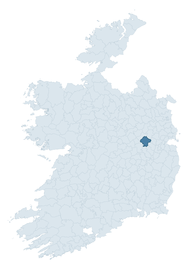
Where this barony sits in the Republic of Ireland
Geology and preservation
Bedrock geology shapes the landscape long before any settlement begins — controlling soil drainage, agricultural potential, the survival of upstanding monuments, and the preservation of buried archaeology. The figures below come from the Geological Survey Ireland 1:100,000 bedrock map.
The bedrock underlying Carbury is predominantly limestone (92% of the barony by area), laid down during the Carboniferous period (100% by area, around 359 to 299 million years ago). Limestone is the most heritage-rich bedrock in Ireland. It supports fertile, well-drained soils that favoured dense Early Medieval settlement and Norman manorial agriculture, and it weathers into karst features — sinkholes, caves, swallow holes, and souterrains — that frequently carry archaeology. Where peat overlies limestone, organic preservation can be exceptional. The single largest mapped unit is the Lucan Formation (70% of the barony's bedrock). With only 2 distinct rock types mapped, the barony is geologically uniform compared to the rest of the Republic (15th percentile for diversity) — a single coherent bedrock landscape.
Rock type composition
Largest mapped unit: Lucan Formation (70% of the barony)
Placename evidence
Logainm records 5 heritage-diagnostic placenames for Carbury, a modest sample drawn predominantly from the townland record. The dominant stratum is early christian ecclesiastical. The most frequent diagnostic roots are cill- (4) and dún- (1). With a sample of this size the count should be treated as indicative rather than definitive.
Pre-Christian / Early Medieval Defensive
| Root | Count | Meaning |
|---|---|---|
| dún- | 1 | hilltop or promontory fort |
Early Christian Ecclesiastical
| Root | Count | Meaning |
|---|---|---|
| cill- | 4 | church (early) |
Other baronies in Kildare
About this profile
Click any section below to expand.
What is a barony?
A barony is a historic administrative unit in Ireland, broadly equivalent to an English hundred. The 280 baronies used here are from the OSi 2019 National Statutory Boundaries (generalised 20m), covering the 26 counties of the Republic of Ireland. Baronies derive from the Norman period, were formalised in the 17th century, and have not been redrawn for statistical purposes. They vary enormously in area, from compact urban baronies in Dublin to vast upland baronies in Connacht, and should not be compared by raw site count without accounting for area differences.
What counts as a site?
This profile combines three distinct heritage registers, each with its own definition of what constitutes a recordable site:
- Archaeological sites (NMS). The National Monuments Service Sites and Monuments Record (SMR) catalogues every known archaeological monument or site of archaeological interest in the Republic, from prehistoric burial mounds and ringforts to medieval churches and post-medieval defensive works. Inclusion does not require legal protection — only that the site has been identified, surveyed, and assessed as having archaeological value. A separate subset of these sites lies within a recorded protection zone, which gives them statutory protection under the National Monuments Acts.
- Listed buildings (NIAH). The National Inventory of Architectural Heritage records buildings of architectural, historical, archaeological, artistic, cultural, scientific, social, or technical interest. Each surveyed structure is appraised on a five-tier scale: International, National, Regional, Local, and Record-Only. The NIAH appraisal is informational rather than strictly statutory, but it underpins local-authority Record of Protected Structures (RPS) listings.
- Heritage placenames (Logainm). Logainm is the authoritative database of Irish placenames maintained by the Placenames Branch. This profile applies a heritage-diagnostic classifier to the Irish-language form of each townland name, flagging roots that signal defensive sites (ráth-, lios-, dún-, caiseal-, cathair-), ecclesiastical foundations (cill-, teampall-, domhnach-, mainistir-), prehistoric burial-ritual features (tuaim-, carn-, leaba-), or Norse-contact settlement (gall-). Townlands without one of these diagnostic roots are not flagged here — they may still carry historical significance, but that significance is not encoded in the name itself.
Editorial principles
The narrative sections of this profile follow several explicit principles:
- Evidential. Every claim about this barony’s heritage character is anchored in the underlying register data. Where a site count, a placename count, or a percentile rank is cited, it is computed from the source datasets at export time, not estimated.
- Comparative. Counts and metrics are reported alongside their percentile rank against the other 279 ROI baronies. A barony with 50 ringforts in absolute terms could be unusually high or unusually low depending on its size and regional context; percentile ranking removes that ambiguity.
- Transparent on limits. Where a register has known coverage gaps, survey biases, or data-quality issues that affect this barony’s figures, the profile flags them rather than presenting the numbers as definitive.
- No interpretation beyond what the data supports. The narrative does not speculate about historical events, social dynamics, or cultural meaning beyond what the recorded heritage and placename evidence directly attests.
Data caveats and limits
- NMS Sites and Monuments Record is the product of survey campaigns conducted at different intensities across different counties and decades. Some baronies have been surveyed more thoroughly than others, and absolute counts should be read in that light. Sites destroyed by development before survey are typically not represented; sites in heavily forested or upland terrain are sometimes under-recorded.
- NIAH coverage is broadly complete for the Republic of Ireland but the survey was conducted on a rolling county-by-county basis, and the most recent appraisal date varies. Buildings demolished or substantially altered after their original survey may still appear in the register; conversely, recent buildings of merit may not yet have been appraised.
- Logainm classification applies a deliberately conservative pattern-matching approach to the Irish-language townland forms. The classifier prioritises true positives over recall: a townland may carry a heritage signal that the classifier doesn’t recognise, particularly where the diagnostic root has been heavily anglicised or where the townland name draws on a less common term. The 60,000+ townland records and ~9,800 classified placenames give a substantial signal at barony scale, but individual townland names should be checked against Logainm directly for definitive interpretation.
- Period attribution. The chronological distribution reflects only those NMS sites that carry a recognised period attribution in the source data. Sites listed as “Unknown” period are excluded from the dated subset.
- Boundary changes. Some baronies have undergone minor boundary adjustments since their 19th-century definition; the OSi 2019 generalised boundaries used here are the current statutory definition and may differ slightly from historical maps in border areas.
- Bedrock geology is mapped at 1:100,000 scale, which means local variation within a barony — small pockets of different rock type, mineral veins, alluvium overlying bedrock — is generalised. The dominant-system and rocktype figures are area-weighted, so a barony reading “70% Carboniferous limestone” may still contain small but archaeologically important pockets of older or younger rock. Around 3% of GSI polygons do not match the lexicon and contribute no rocktype or system attribution.
Data sources
- National Monuments Service — Sites and Monuments Record (SMR) https://data.gov.ie/dataset/national-monuments-service-archaeological-survey-of-ireland
- National Inventory of Architectural Heritage (NIAH) https://data.gov.ie/dataset/national-inventory-of-architectural-heritage-niah-national-dataset
- Logainm — Placenames Database of Ireland https://www.logainm.ie/
- Ordnance Survey Ireland — National Statutory Barony Boundaries 2019 https://data-osi.opendata.arcgis.com/
- EURODEM — European Digital Elevation Model https://www.mapsforeurope.org/datasets/euro-dem
- ESA WorldCover https://esa-worldcover.org/en
- Geological Survey Ireland — 1:100,000 Bedrock Geology https://www.gsi.ie/en-ie/data-and-maps/Pages/Bedrock.aspx
Explore more: Search any of the 280 ROI baronies, browse by historical province, or read the methodology and data sources for the full Republic of Ireland Heritage Tool.