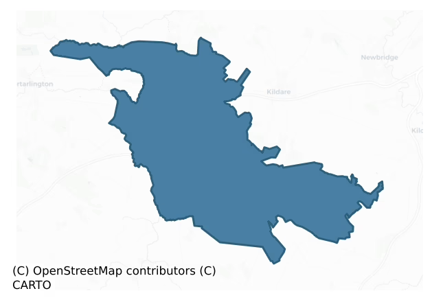
Offaly West is a barony of County Kildare, in the historical province of Leinster (Irish: Uíbh Fhailí Thiar), covering 164 km² of land. The barony records 167 NMS archaeological sites and 134 NIAH listed buildings, placing it at around the 14th percentile among 280 ROI baronies for sites per km². This means it is in the bottom fifth of all baronies for sites per km². Dated archaeological evidence runs from the Neolithic through to the Modern, spanning 8 of 9 archaeological periods, placing the barony in the 69th percentile among 280 ROI baronies for chronological depth. This means it is in the top third of all baronies for chronological depth. The largest dated subset of recorded sites dates to the Iron Age.
Heritage at a glance
Percentile rankings throughout this profile compare each barony only against the other 279 Republic of Ireland baronies.
The recorded heritage of Offaly West
The National Monuments Service Sites and Monuments Record (SMR) is the statutory inventory of archaeological sites for the Republic of Ireland, maintained by the Department of Tourism, Culture, Arts, Gaeltacht, Sport and Media. Sites recorded here include earthworks, ringforts, megalithic tombs, ecclesiastical remains, and post-medieval features; not every record is legally protected, but each is registered as a monument of archaeological interest.
The National Monuments Service records 167 archaeological sites in Offaly West, putting it at the 14th percentile among 280 ROI baronies for sites per km². This means it is in the bottom fifth of all baronies for sites per km². A sparse recorded total of this kind in Ireland often reflects survey priority rather than genuine absence of past activity. Of these, 146 (87%) fall within a recorded monument protection zone. The dominant category is defensive sites — ringforts, enclosures, hillforts, and stone forts (74 sites, 44% of the record). The most diagnostically specific type is Church (11 records, 7% of the barony's NMS total) — compared to an ROI average of 4% across all baronies where this type occurs. Church is a building used for public Christian worship, of any date from c. 500 AD onwards. The broader 'Enclosure' classification — which catches unclassified ringforts and field enclosures — accounts for a further 50 records (30%) and reflects the difficulty of sub-classifying degraded earthworks from surface evidence alone. Across the barony's 164 km², this gives a recorded density of 1.02 sites per km².
Most common monument types
Hover or tap a monument type to see its definition.
| Type | Count |
|---|---|
| Enclosure a banked or ditched feature of uncertain type, used as a catch-all where the original function cannot be determined from surface evidence | 50 |
| Church a building used for public Christian worship, of any date from c. 500 AD onwards | 11 |
| Graveyard a burial area associated with a church, in use from the medieval period onwards | 11 |
| Fulacht fia a horseshoe-shaped Bronze Age burnt mound built around a sunken trough beside a water source, traditionally interpreted as a cooking site | 8 |
| Ringfort – rath an earthen ringfort enclosed by a bank and external ditch — the most common Early Medieval farmstead, broadly dated 500–1000 AD | 7 |
| Moated site | 7 |
| Castle – unclassified a castle whose form cannot be precisely classified, dating somewhere between the late 12th and 16th centuries | 6 |
| Ritual site – holy well a well or spring traditionally associated with a saint, often credited with healing properties; many trace earlier ritual origins but devotion is documented from the medieval period onwards | 5 |
Chronological distribution
The dated archaeological record for Offaly West spans from the Neolithic through to the Modern, with activity attested across 8 of 9 archaeological periods. Every period from earliest to latest is represented in the record — an unbroken sequence of dated activity across the full chronological span. Activity concentrates most heavily in the Iron Age (59 sites, 47% of dated material), with the Middle Late Bronze Age forming a secondary peak (17 sites, 13%). A further 41 recorded sites (25% of the overall NMS register for the barony) carry no period attribution — appearing as 'Unknown' in the bar chart below. This typically reflects either records that pre-date the standardised period vocabulary or sites awaiting specialist dating review, rather than a genuine absence of chronological evidence.
Sample of recorded monuments
Show 25 sample monuments (of 167 total)
A representative sample of 25 recorded monuments drawn from the barony’s 167 total NMS entries. Sites within a recorded monument protection zone and rarer site types are prioritised so the list shows a meaningful cross-section rather than only the most common type. Each entry shows the official Sites and Monuments Record reference number and the description published by the National Monuments Service.
Ecclesiastical enclosure
Visible on a 1971 aerial photograph (CUCAP BGH 46) as the faint cropmark of fairly narrow fosse defining a large circular area (est. diam. c. 120m) occupying the upper portion of the W end of a pasture ridge just above…
Visible on a 1971 aerial photograph (CUCAP BGH 46) as the faint cropmark of fairly narrow fosse defining a large circular area (est. diam. c. 120m) occupying the upper portion of the W end of a pasture ridge just above the flood plain at a meander in the Black River, a tributary of the Barrow, which flows around the site N-W-S. The cropmark was not visible at ground level in 1986 (SMR file), or on the present visit. A church site (KD021-001003—-) and a graveyard (KD021-001004—-) lie at the centre of the enclosure; all suggesting the existence of an early ecclesiastical site here (KD021-001005-).
Compiled by: Gearóid Conroy
Date of upload: 13 October 2011
Decoy pond
Although not indicated on the 1st. ed. (1838) of the OS 6-inch map, a large, square enclosure (est. ext. dims. L c. 105m; Wth c. 105m) is shown on the 1939 OS 6-inch map revision defined by a broad bank which widens…
Although not indicated on the 1st. ed. (1838) of the OS 6-inch map, a large, square enclosure (est. ext. dims. L c. 105m; Wth c. 105m) is shown on the 1939 OS 6-inch map revision defined by a broad bank which widens internally at the centre of each side. By 1972, the site had been levelled and bulldozing operations were noted in the area (SMR file). In well-drained, improved pasture. A shallow (D0.4-0.6m), rectangular hollow survives, and is know locally as 'the decoy'. (CUCAP BGH 70, 71).
Compiled by: Gearóid Conroy
Date of upload: 13 October 2011
Bridge
According to the Countess of Drogheda (1902-3, 235), the bridge was possibly crossed by the Earl of Essex in 1599, and later by Cromwell on his way to destroy Lea Castle in Co. Laois (LA005-006—-). A five-arch bridge…
According to the Countess of Drogheda (1902-3, 235), the bridge was possibly crossed by the Earl of Essex in 1599, and later by Cromwell on his way to destroy Lea Castle in Co. Laois (LA005-006—-). A five-arch bridge (L c. 40m; Wth 4.1m) spans the S-flowing River Barrow, just N of Monasterevin. It is constructed of roughly coursed, undressed limestone blocks and, although rebuilt in places, appears to contain a good deal of original fabric. It has been extensively repointed and the bases of the piers are of concrete. Four triangular cutwaters on the N, upstream, face rise the full height and are incorporated into the parapet as small refuges. Similar cutwaters on the S-face are only the height of the base of the piers. Traces of a sixth, lower, blocked-up, overgrown arch are visible on the S-face of the bridge at its W end. It is also known as 'Ballagh Bridge'.
Compiled by: Gearóid Conroy
Date of upload: 20 October 2011
Castle – hall-house
On level pasture, with a motte (KD022-016—-) visible c. 150m to the W, and a church (KD022-018—-) and graveyard (KD022-018001-) c. 35m to ENE, and (by association) the possible location of an early castle. The site…
On level pasture, with a motte (KD022-016—-) visible c. 150m to the W, and a church (KD022-018—-) and graveyard (KD022-018001-) c. 35m to ENE, and (by association) the possible location of an early castle. The site consists of the very poorly preserved, L-shaped remains of a featureless, one-storied S-corner formed by SE and SW walls (int.dims. L 2.4m NE-SW; Wth 1.3m NW-SE; wall T 1.9m; ext.H 3.5m) built of thin, coursed flags with a very gentle base-batter. Traces of a N corner, 13.5m to NE, and slightly off-line to W, of the S corner, survive as a low, L-shaped mass of mortared masonry without facing-stones (int. dims. L 3.4m NW-SE; Wth 2.1m NE-SW; wall T max.3m; H 0.6-0.9m). Immediately to its S an inaccessible, short, narrow, rectangular, stone-built, subterranean passageway (int. dims. L 1.5m E-W; Wth 1.1m N-S) with a wicker-centered, pointed-arched vaulted roof appears to be a later feature. It is misidentified 'Souterrain' on the current edition (1939) of the OS 6-inch map. Traces of a fosse enclosing a possible bawn (KD022-017001-) to N noted in 1986 (SMR File) are no longer visible at ground level but a low scarp (H 0.8m) may mark its line. The site may have been a late 13th/14th century hall-keep and bawn?
Compiled by: Geaóid Conroy
Date of upload: 06 december 2011
Cross – Wayside cross
On the N-verge of the road. A lozenge-shaped, limestone block (max. dims L 1.2m; Wth 1m; H 0.47m) with a shallow rectangular mortice (dims. L 0.4m; Wth 0.25m; D 0.15m). According to Fitzgerald (1918-19, 258), ' … (a)…
On the N-verge of the road. A lozenge-shaped, limestone block (max. dims L 1.2m; Wth 1m; H 0.47m) with a shallow rectangular mortice (dims. L 0.4m; Wth 0.25m; D 0.15m). According to Fitzgerald (1918-19, 258), ' … (a) cross was erected to the memory of Sir Maurice FitzGerald, Knt., of Lackagh, who was slain at this spot in 1520 in an affray with Con mac Melaghlin O'More of Leix, Chief of his name. Of this cross, only two portions are now known to exist – (1) the socketed base known as the "Wart Stone"; and (2) a portion of the shaft, richly sculpted, now at Kilkea Castle (KD037-017—-). (Fitzgerald 1891, 250-51; Crawford 1907, 237; Strath 1935-8, 191-4; Price 1959, 166; Tickell 1960, 369)
Compiled by: Gearóid Conroy
Date of upload: 06 December 2011
Crannog
In 1893, oak beams with mortices and other joinery features were discovered in a low, irregular mound on the edge of a bog. Archaeological excavations by Vigours (JKAS 1895, 399-402) uncovered ox and deer bone, some…
In 1893, oak beams with mortices and other joinery features were discovered in a low, irregular mound on the edge of a bog. Archaeological excavations by Vigours (JKAS 1895, 399-402) uncovered ox and deer bone, some worked bone and antler implements, and half of one stone of rotary quern was found on a 'floor' beneath the beams.
Compiled by: Gearóid Conroy
Date of upload: 22-12-2011
Religious house – Cistercian monks
In wooded, landscaped, former demesne grounds on the E bank of the S-flowing River Barrow. According to Gwynn and Hadcock (1970, 398), St. Emin (Evin) built a monastery at ‘Rosglas na Muimneach’. Regarding this…
In wooded, landscaped, former demesne grounds on the E bank of the S-flowing River Barrow. According to Gwynn and Hadcock (1970, 398), St. Emin (Evin) built a monastery at ‘Rosglas na Muimneach’. Regarding this monastery, the Countess of Drogheda records (1902-3, 235), '… the old Yew Tree Cemetery (KD021-001004-, in Clogheen townland, N of Monasterevin town) [was] where there was once a branch of St. Evin's Monastery, and here was kept for long afterwards St. Evin's bell as a swearing relic.’ While no visible surface trace of the early monastery survives, sometime between 1177 and 1181, Dermot O'Dempsey, King of Offaly, founded an abbey, probably on its site, which shortly afterwards became the Cistercian Abbey of Rosglas or ‘de Rosea Vallis’, dedicated to SS Mary and Benedict (Gwynn and Hadcock 1970, 142). No visible surface trace of that abbey survives either, but some of its foundations and/or fabric may be incorporated into the present Moore Abbey house (KD026-002—-). A church is shown to the N of the house on a 1759 survey map of Monasterevin Demesne by Scale (NLI Ms. 21. F. 37 (131-71) Map 147), but no visible surface trace survives. A medieval font (KD026-001001-) in a modern chapel there may have come from the abbey. Burials (KD026-003—-) uncovered in the mid and late-19th century just E of the house were probably associated with the former monastery. In 1996, archaeological monitoring of service trenches (Mullins, Clare. Excavation Licence no. 96E0024ext., Onl…
Children's burial ground
On the S-face, just off the crest, of a low narrow, E-W pasture ridge. A shallow sub-circular hollow (7m N-S; 5m E-W; D 08-1m), open towards the S, contains some half-dozen low, largely earthfast, unworked, field stones…
On the S-face, just off the crest, of a low narrow, E-W pasture ridge. A shallow sub-circular hollow (7m N-S; 5m E-W; D 08-1m), open towards the S, contains some half-dozen low, largely earthfast, unworked, field stones (av. max L 0.5m; Wth 0.4m; H 0.2m) marking burials. Smaller field-cleared stones have been thrown into the site. In 2002, archaeological testing (Excavation licence no. 02E0301 Online www.excavations.ie Accessed 08 August 2012) in advance of construction of the M7 Heath–Mayfield Motorway Scheme revealed the disarticulated remains of an infant, confirming the presence of a children’s burial-ground. Subsequent geo-physical survey and excavation in 2003, (Excavation licence nos. 03E0184 and 03E0350 Online www.excavations.ie Accessed 08 August 2012) revealed the remains of some 70 child inhumations, with the volume of burial activity having caused multiple truncations to the remains. Finds included shroud pins, coffin nails and organic materials.
Compiled by: Gearóid Conroy
Date of upload: 23 August 2012
Barrow – ring-barrow
Mid-way down a long moderately steep SW-facing slope in tillage. In 2000 (SMR file), the monument survived as a small partially overgrown, circular area (int. diam 5m) enclosed by a low earthen bank (int. H 0.15m; Wth…
Mid-way down a long moderately steep SW-facing slope in tillage. In 2000 (SMR file), the monument survived as a small partially overgrown, circular area (int. diam 5m) enclosed by a low earthen bank (int. H 0.15m; Wth 2.4m; ext. H 0.5m). with no trace of an outer fosse. However, ploughing up to the edge of the monument may have resulted in its infilling. In 2007, the monument was completely ploughed over revealing a central circular area of grey ash, charcoal and burnt bone which was girdled by a band (Wth c. 1.2m) of pale yellow soil with possible human bone, charcoal and burnt earth inclusions.
Compiled by: Gearóid Conroy
Date of upload: 30 August 2012
Religious house – unclassified
On the gentle N-slope of a shallow E-W valley through a small river flows W. Modern housing has been constructed immediately to the W and NW. In 1837, according to O’Conor’s Ordnance Survey Letter (Herity 2002, 146…
On the gentle N-slope of a shallow E-W valley through a small river flows W. Modern housing has been constructed immediately to the W and NW. In 1837, according to O’Conor’s Ordnance Survey Letter (Herity 2002, 146 (159)), ‘… in Nurney village is pointed out a spot, where, it is said, there was formerly a nunnery. No remains are now observable; but a very small portion of the site, where some of the walls occupied, is said not to have been dug up, or tilled.’ The nunnery is not mentioned by Gwynn and Hadcock (1970). In 1967, burials (KD027-025001-) were uncovered in the vicinity. No surface traces of the nunnery were visible in 1986 (SMR file). In 1987, archaeological trial-trenching (Excavation Licence no. 97E0142) was undertaken in advance of a private development immediately S of the presumed location of the nunnery. No structures, deposits or finds of archaeological interest were uncovered. (http://www.excavations.ie/Pages/Details.php?Year=&County=Kildare&id=1915 Accessed 07-09-2012)
Compiled by: Gearóid Conroy
Date of upload: 10 October 2012
Megalithic structure
Near the top of a long and moderately steep SW-facing slope in tillage. A ringbarrow (KD027-004—-) lies c. 130m downslope to the S. While named ‘Dolmen’ on the latest ed. (1939) of the OS 6-inch map, the site…
Near the top of a long and moderately steep SW-facing slope in tillage. A ringbarrow (KD027-004—-) lies c. 130m downslope to the S. While named ‘Dolmen’ on the latest ed. (1939) of the OS 6-inch map, the site comprises a pair of rough boulders; a larger S one (L 2.5m; Wth 2.5m; H 1.8m) partly resting on a smaller N one (L 1.6m; Wth 1.3m; H 0.7m). Although not accepted as a megalithic tomb by de Valera and O’Nualláin (1972, 101), they note that a human skeleton is said to have been found at the site. (Comerford 1883, II, 239)
Compiled by: Gearóid Conroy
Date of upload: 30 August 2012
Barrow – mound barrow
On a low knoll in level pasture. Shown on the OS 25-inch map as a small oval shaped mound(approx. int. diam. c. 18m NNE-SSW; c. 10m ENE-WSW; approx. H 6m) enclosed by a broad bank with a trigonometrical station on the…
On a low knoll in level pasture. Shown on the OS 25-inch map as a small oval shaped mound(approx. int. diam. c. 18m NNE-SSW; c. 10m ENE-WSW; approx. H 6m) enclosed by a broad bank with a trigonometrical station on the bank at SE (marked OD 254 feet on the 1839 ed. of the OS 6-inch map) and named ‘Susan’s Fort’. Gravel pits have been dug out of the knoll and no visible surface trace of an enclosing element was visible in 1987 (SMR file). In recent times a human skull was discovered in the exposed section of a gravel pit in the NE quadrant of the monument. The skull was retrieved by the NMI and verified as an ancient skull by Laureen Buckley. A number of exposed section faces in the monument indicate a multi-layered construction. There are a number of badger sets on the monument so it is likely that the skull was displaced by animals.
Compiled by: Gearóid Conroy
Revised by: Caimin O'Brien
Date of revised upload: 20 January 2017
Designed landscape feature
In a built up farmyard just N of Fearaun House. Shown on the 1st ed. (1839) of the OS 6-inch map as a small circular enclosure (est. dia. c. 18m) encircled by a band of vegetation, but not recorded on subsequent OS…
In a built up farmyard just N of Fearaun House. Shown on the 1st ed. (1839) of the OS 6-inch map as a small circular enclosure (est. dia. c. 18m) encircled by a band of vegetation, but not recorded on subsequent OS mapping. No visible surface trace survives. May have been an ornamental landscape feature associated with Fearaun House.
Compiled by: Gearóid Conroy
Date of upload: 09 October 2013
Bastioned fort
On a long gentle S-facing, pasture slope. Depicted on an 1853 sketch of an original ‘Plan of the Castle of Ballyshannon, with its Outworks, in 1650’ as a bastioned fort – shown under attack during the Confederate War…
On a long gentle S-facing, pasture slope. Depicted on an 1853 sketch of an original ‘Plan of the Castle of Ballyshannon, with its Outworks, in 1650’ as a bastioned fort – shown under attack during the Confederate War (1641-53) – (Fitzgerald 1899-1902, 447). A rectangular area is shown (est. dims. from OS 25-inch map c. 40m N-S; c. 30m E-W) with triangular bastions on each corner projecting NW, NE, SE and SW. Ballyshannon Castle (KD032-003002-) is shown in the interior. An accompanying, ‘A description of the strong fort of Ballisanon, in Leinster (1650)’ lists an inner ‘moat … in some places 40 foot [c. 12m] broad … the graft [ditch] 25 foot [c. 7.6m] in five places and 12 foot [c. 3.6m] deep (with a drawbridge near the NW angle) … the Rampire and Parapet 30 [c. 9m] foot thick and in some places 25 foot [c. 7.6m] high’. Two outworks are also depicted, and are annotated, ‘The workes of the Towne’. The first, L-shaped, encloses all but the E side and portion of the SE angle of the bastioned fort, as well as an earlier motte (KD028-058001-) and a church (KD028-058002-) to the N, and an entrance is shown mid way along its N side. A second outwork, with projecting bastions, runs outside and parallel to the W and N sides of the first. ‘The Black Castle’ (KD032-003003-) is shown defending a gateway on its W side. No visible surface traces survive.
Compiled by: Gearóid Conroy
Date of upload: 21 May 2013
Ecclesiastical site
According to the Countess of Drogheda (1902-3, 235), '… the old Yew Tree Cemetery (was) where there was once a branch of St. Evin's Monastery (KD026-001—-), and here was kept for long afterwards St. Evin's bell as a…
According to the Countess of Drogheda (1902-3, 235), '… the old Yew Tree Cemetery (was) where there was once a branch of St. Evin's Monastery (KD026-001—-), and here was kept for long afterwards St. Evin's bell as a swearing relic.' The surviving remains comprise Yew Tree Graveyard (KD021-001004-), a possible ecclesiastical enclosure (KD021-001002-) and a church site (KD021-001003-).
Compiled by: Gearóid Conroy
Date of upload: 13 October 2011
Coffin-resting stone
On the roadside outside the entrance to a graveyard (KD022-011001-). A long, ivy clad and partially tumbled, stone built, rectangular structure (L 3m; Wth 1m; H 0.8m) may be the remains of a coffin rest.
Compiled by:…
On the roadside outside the entrance to a graveyard (KD022-011001-). A long, ivy clad and partially tumbled, stone built, rectangular structure (L 3m; Wth 1m; H 0.8m) may be the remains of a coffin rest.
Compiled by: Gearóid Conroy
Date of upload: 05 December 2011
Bawn
On level pasture. Traces of a fosse possibly enclosing a bawn to the N of a possible hall house (KD022-017001-) noted in 1986 (SMR File) are no longer visible at ground level, but a low scarp (H 0.8m) may mark its line.…
On level pasture. Traces of a fosse possibly enclosing a bawn to the N of a possible hall house (KD022-017001-) noted in 1986 (SMR File) are no longer visible at ground level, but a low scarp (H 0.8m) may mark its line.
Compiled by: Geaóid Conroy
Date of upload: 06 december 2011
Concentric enclosure
Cropmark of enclosure (approx. diam. 28m) within a larger oval-shaped enclosure (diam. 50m NW-SE x 40m NE-SW) visible on Google earth aerial imagery.
See attached image taken from Google Earth aerial photographs…
Cropmark of enclosure (approx. diam. 28m) within a larger oval-shaped enclosure (diam. 50m NW-SE x 40m NE-SW) visible on Google earth aerial imagery.
See attached image taken from Google Earth aerial photographs taken 28/06/2018.
Compiled by: Caimin O'Brien based on details kindly provided by Faith Bailey.
Date of upload: 20 November 2018
Castle – motte
At the base of a slope in tillage, with a slight ridge to the NE. A ruined tower house (KD022-017—-) stands c. 150m to the E, with a church (KD022-018—-) and graveyard (KD022-018001-) just beyond to the ENE. An…
At the base of a slope in tillage, with a slight ridge to the NE. A ruined tower house (KD022-017—-) stands c. 150m to the E, with a church (KD022-018—-) and graveyard (KD022-018001-) just beyond to the ENE. An overgrown, circular, steep-sided, earthen mound (H. 4m; est. base diam. c. 35m ) with a concave summit (diam. 16m), is girdled by a shallow fosse (Wth. 2m) with traces of an outer bank.
Compiled by: Gearóid Conroy
Date of upload: 06 December 2011
House – 17th century
In wooded, landscaped, former demesne grounds on the E bank of the S-flowing River Barrow. A 1596 lease on the Manor of Evon (Monasterevin) lists, ‘ … a fair hall, a stable, kitchen, and other rooms, an orchard,…
In wooded, landscaped, former demesne grounds on the E bank of the S-flowing River Barrow. A 1596 lease on the Manor of Evon (Monasterevin) lists, ‘ … a fair hall, a stable, kitchen, and other rooms, an orchard, watermill …' (Fitzgerald 1904, 256-7). According to Bence-Jones (1978, 210), the present Moore Abbey house is a 1767 rebuilding of a 17th century [16th/17th century?] house, itself built on the site of a Carmelite abbey (KD026-001—-). It was the sometime seat of the Moores, earls of Drogheda, and for a time, the residence of the noted singer, John McCormack (Killanin and Duignan 1967, 379). Now much renovated and operated as a health care facility by the Sisters of Charity of Jesus and Mary, the entrance incorporates a fine 17th century surround of the Lofus family, and the later porch shows the coat of arms of the Moore family. A date stone of 1607, and two 16th century jamb stones, reused in a window, are incorporated in the E wall. The latter may have come from an earlier house, or from the abbey. The large hall to the right of the entrance may also date from the 17th century, as may the vaulted basements where, although plastered, red brick is visible in some of the arches.
Compiled by: Gearóid Conroy
Date of upload: 30 July 2012
Castle – motte
At the top of a long gentle, S-facing pasture slope. A possible medieval church site (KD028-058002-) stands in a graveyard (KD028-058004-) c. 50m to the W, and the levelled Ballyshannon Castle (KD032-003002-) stood c.…
At the top of a long gentle, S-facing pasture slope. A possible medieval church site (KD028-058002-) stands in a graveyard (KD028-058004-) c. 50m to the W, and the levelled Ballyshannon Castle (KD032-003002-) stood c. 80m to the SSW. Depicted on an 1853 sketch of an original ‘Plan of the Castle of Ballyshannon, with its Outworks, in 1650’, as a steep-sided, conical mound, with a possible bank enclosing the summit, on which a large tree is shown; and annotated, 'The high mount fortified which wee stormed' (Fitzgerald 1899-1902, 447). The plan shows an outwork skirting the base of the motte along the N, with a second outwork further N. A low denuded, grass-covered and partially tree-clad, oval, earthen mound (base diams. 30m E-W; 20m N-S; H 2m at S-3.5-4m at E, including natural slope).
Compiled by: Gearóid Conroy
Date of upload: 21 May 2013
House – 17th century
At the end of a laneway, in mixed pasture and tillage. Described by Ó Danachair (1966-7, 243-6) as a fine specimen of a “Thatched Mansion”, or large two-storied thatched house, which was common as the dwelling of…
At the end of a laneway, in mixed pasture and tillage. Described by Ó Danachair (1966-7, 243-6) as a fine specimen of a “Thatched Mansion”, or large two-storied thatched house, which was common as the dwelling of prosperous farmers and lesser gentry in the 17th and 18th-centuries. It was originally a traditional direct entry house, and was built before 1717. There are two large rooms each, on ground and first floor, divided by partitions, and access to first floor-level was originally by means of a ladder. There are fireplaces in each room in the gable walls, and there is a built-in oven in the kitchen There is a second two-storey thatched house with an apparently similar layout c. 300m to the NNE in the same townland, which is not mentioned by O’Danachair.
Compiled by: Gearóid Conroy
Date of upload: 12 November 2013
Enclosure – large enclosure
Cropmark of large roughly oval-shaped enclosure (approx. dims. 83m E-W x 55m N-S) visible on Google earth aerial imagery.
See attached image taken from Google Earth aerial photographs taken 28/06/2018.
Compiled…
Cropmark of large roughly oval-shaped enclosure (approx. dims. 83m E-W x 55m N-S) visible on Google earth aerial imagery.
See attached image taken from Google Earth aerial photographs taken 28/06/2018.
Compiled by: Caimin O'Brien based on details kindly provided by Faith Bailey.
Date of upload: 20 November 2018
Barrow – ditch barrow
Cropmark of small circular-shaped enclosure or possible ditch-barrow (approx. diam. 13m) visible on Google Earth aerial photograph taken 28/06/2018
See attached image taken from Google Earth
Compiled by: Caimin…
Cropmark of small circular-shaped enclosure or possible ditch-barrow (approx. diam. 13m) visible on Google Earth aerial photograph taken 28/06/2018
See attached image taken from Google Earth
Compiled by: Caimin O'Brien based on details kindly provided by Pat Reid
Date of upload: 05 December 2018
Enclosure
Visible on a 1971 aerial photograph (CUCAP BGH 71) as the cropmark of a small circular enclosure, apparently defined by a fosse. In open, level, well-drained, improved pastureland. No visible surface trace survived in…
Visible on a 1971 aerial photograph (CUCAP BGH 71) as the cropmark of a small circular enclosure, apparently defined by a fosse. In open, level, well-drained, improved pastureland. No visible surface trace survived in 1986 (SMR file).
Compiled by: Gearóid Conroy
Date of upload: 20 October 2011
Listed buildings
The National Inventory of Architectural Heritage (NIAH) is a state survey appraising buildings of architectural, historical, archaeological, artistic, cultural, scientific, social, or technical interest. Each surveyed structure receives a rating from International (the highest, for buildings of European importance) through National, Regional, Local, and Record-Only.
The NIAH records 134 listed buildings in Offaly West (62nd percentile across ROI baronies). Among these, 5 are graded National — buildings of interest to the whole of Ireland rather than only its region. The Republic holds 937 National-graded buildings in total, so this barony accounts for around 1% of the national total. Construction dates concentrate most heavily in the Victorian (1830-1900) period. The most-recorded building type is house (44 examples, 33% of the listed stock).
Terrain and environment
Mean elevation across the barony is 73m — the 35th percentile among 280 ROI baronies for elevation. This means it is in the lower half of all baronies for elevation. Elevation matters for heritage because higher-altitude baronies typically favour defensive monuments — ringforts and hilltop forts placed on prominent ground — while lowland baronies are more likely to carry the dense settlement and church networks of intensive agricultural landscapes. Mean slope is 1.9° — the 4th percentile among 280 ROI baronies for slope. This means it is in the bottom tenth of all baronies for slope. This is broadly flat terrain, the kind of landscape best suited to intensive agriculture. Slope is a key control on both land use and archaeological preservation: steep ground resists ploughing and tends to preserve earthworks intact, while gentle slopes favour intensive cultivation that damages or destroys surface archaeology over time. The Topographic Wetness Index averages 12.0, the 98th percentile among 280 ROI baronies for wetness. This means it is in the top tenth of all baronies for wetness. This is wet, slow-draining ground by ROI standards — the kind of landscape that may carry waterlogged archaeological sites of unusual preservation value. Drainage matters for heritage because poorly-drained ground preserves organic archaeology (wooden trackways, leather, textiles, and on rare occasions human remains) far better than free-draining soil; well-drained ground favours arable use but destroys organic material rapidly. The land-cover mosaic combines improved grassland (64%), arable farmland (21%), and woodland (13%), giving a mixed agricultural and semi-natural landscape.
Terrain measurements
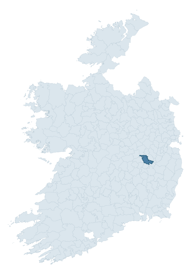
Where this barony sits in the Republic of Ireland
Geology and preservation
Bedrock geology shapes the landscape long before any settlement begins — controlling soil drainage, agricultural potential, the survival of upstanding monuments, and the preservation of buried archaeology. The figures below come from the Geological Survey Ireland 1:100,000 bedrock map.
The bedrock underlying Offaly West is predominantly limestone (96% of the barony by area), laid down during the Carboniferous period (98% by area, around 359 to 299 million years ago). Limestone is the most heritage-rich bedrock in Ireland. It supports fertile, well-drained soils that favoured dense Early Medieval settlement and Norman manorial agriculture, and it weathers into karst features — sinkholes, caves, swallow holes, and souterrains — that frequently carry archaeology. Where peat overlies limestone, organic preservation can be exceptional.
Rock type composition
Largest mapped unit: Milford Formation (23% of the barony)
Placename evidence
Logainm records 10 heritage-diagnostic placenames for Offaly West, a modest sample drawn predominantly from the townland record. The dominant stratum is early christian ecclesiastical. The most frequent diagnostic roots are cill- (4) and cillín- (2). With a sample of this size the count should be treated as indicative rather than definitive.
Pre-Christian / Early Medieval Defensive
| Root | Count | Meaning |
|---|---|---|
| ráth- | 1 | earthen ringfort |
| dún- | 1 | hilltop or promontory fort |
Early Christian Ecclesiastical
| Root | Count | Meaning |
|---|---|---|
| cill- | 4 | church (early) |
| cillín- | 2 | unconsecrated burial ground |
| mainistir- | 1 | monastery |
| gráinseach- | 1 | monastic farm / grange |
Other baronies in Kildare
About this profile
Click any section below to expand.
What is a barony?
A barony is a historic administrative unit in Ireland, broadly equivalent to an English hundred. The 280 baronies used here are from the OSi 2019 National Statutory Boundaries (generalised 20m), covering the 26 counties of the Republic of Ireland. Baronies derive from the Norman period, were formalised in the 17th century, and have not been redrawn for statistical purposes. They vary enormously in area, from compact urban baronies in Dublin to vast upland baronies in Connacht, and should not be compared by raw site count without accounting for area differences.
What counts as a site?
This profile combines three distinct heritage registers, each with its own definition of what constitutes a recordable site:
- Archaeological sites (NMS). The National Monuments Service Sites and Monuments Record (SMR) catalogues every known archaeological monument or site of archaeological interest in the Republic, from prehistoric burial mounds and ringforts to medieval churches and post-medieval defensive works. Inclusion does not require legal protection — only that the site has been identified, surveyed, and assessed as having archaeological value. A separate subset of these sites lies within a recorded protection zone, which gives them statutory protection under the National Monuments Acts.
- Listed buildings (NIAH). The National Inventory of Architectural Heritage records buildings of architectural, historical, archaeological, artistic, cultural, scientific, social, or technical interest. Each surveyed structure is appraised on a five-tier scale: International, National, Regional, Local, and Record-Only. The NIAH appraisal is informational rather than strictly statutory, but it underpins local-authority Record of Protected Structures (RPS) listings.
- Heritage placenames (Logainm). Logainm is the authoritative database of Irish placenames maintained by the Placenames Branch. This profile applies a heritage-diagnostic classifier to the Irish-language form of each townland name, flagging roots that signal defensive sites (ráth-, lios-, dún-, caiseal-, cathair-), ecclesiastical foundations (cill-, teampall-, domhnach-, mainistir-), prehistoric burial-ritual features (tuaim-, carn-, leaba-), or Norse-contact settlement (gall-). Townlands without one of these diagnostic roots are not flagged here — they may still carry historical significance, but that significance is not encoded in the name itself.
Editorial principles
The narrative sections of this profile follow several explicit principles:
- Evidential. Every claim about this barony’s heritage character is anchored in the underlying register data. Where a site count, a placename count, or a percentile rank is cited, it is computed from the source datasets at export time, not estimated.
- Comparative. Counts and metrics are reported alongside their percentile rank against the other 279 ROI baronies. A barony with 50 ringforts in absolute terms could be unusually high or unusually low depending on its size and regional context; percentile ranking removes that ambiguity.
- Transparent on limits. Where a register has known coverage gaps, survey biases, or data-quality issues that affect this barony’s figures, the profile flags them rather than presenting the numbers as definitive.
- No interpretation beyond what the data supports. The narrative does not speculate about historical events, social dynamics, or cultural meaning beyond what the recorded heritage and placename evidence directly attests.
Data caveats and limits
- NMS Sites and Monuments Record is the product of survey campaigns conducted at different intensities across different counties and decades. Some baronies have been surveyed more thoroughly than others, and absolute counts should be read in that light. Sites destroyed by development before survey are typically not represented; sites in heavily forested or upland terrain are sometimes under-recorded.
- NIAH coverage is broadly complete for the Republic of Ireland but the survey was conducted on a rolling county-by-county basis, and the most recent appraisal date varies. Buildings demolished or substantially altered after their original survey may still appear in the register; conversely, recent buildings of merit may not yet have been appraised.
- Logainm classification applies a deliberately conservative pattern-matching approach to the Irish-language townland forms. The classifier prioritises true positives over recall: a townland may carry a heritage signal that the classifier doesn’t recognise, particularly where the diagnostic root has been heavily anglicised or where the townland name draws on a less common term. The 60,000+ townland records and ~9,800 classified placenames give a substantial signal at barony scale, but individual townland names should be checked against Logainm directly for definitive interpretation.
- Period attribution. The chronological distribution reflects only those NMS sites that carry a recognised period attribution in the source data. Sites listed as “Unknown” period are excluded from the dated subset.
- Boundary changes. Some baronies have undergone minor boundary adjustments since their 19th-century definition; the OSi 2019 generalised boundaries used here are the current statutory definition and may differ slightly from historical maps in border areas.
- Bedrock geology is mapped at 1:100,000 scale, which means local variation within a barony — small pockets of different rock type, mineral veins, alluvium overlying bedrock — is generalised. The dominant-system and rocktype figures are area-weighted, so a barony reading “70% Carboniferous limestone” may still contain small but archaeologically important pockets of older or younger rock. Around 3% of GSI polygons do not match the lexicon and contribute no rocktype or system attribution.
Data sources
- National Monuments Service — Sites and Monuments Record (SMR) https://data.gov.ie/dataset/national-monuments-service-archaeological-survey-of-ireland
- National Inventory of Architectural Heritage (NIAH) https://data.gov.ie/dataset/national-inventory-of-architectural-heritage-niah-national-dataset
- Logainm — Placenames Database of Ireland https://www.logainm.ie/
- Ordnance Survey Ireland — National Statutory Barony Boundaries 2019 https://data-osi.opendata.arcgis.com/
- EURODEM — European Digital Elevation Model https://www.mapsforeurope.org/datasets/euro-dem
- ESA WorldCover https://esa-worldcover.org/en
- Geological Survey Ireland — 1:100,000 Bedrock Geology https://www.gsi.ie/en-ie/data-and-maps/Pages/Bedrock.aspx
Explore more: Search any of the 280 ROI baronies, browse by historical province, or read the methodology and data sources for the full Republic of Ireland Heritage Tool.