
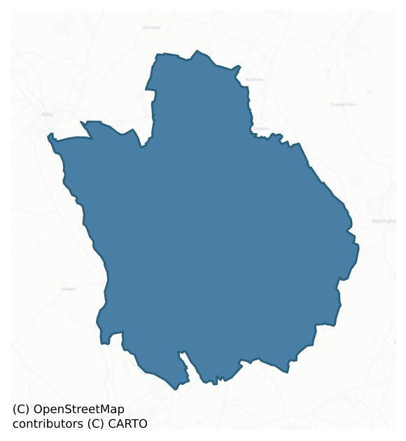
Kilkea And Moone is a barony of County Kildare, in the historical province of Leinster (Irish: Cill Chá agus Maoin), covering 188 km² of land. The barony records 509 NMS archaeological sites and 106 NIAH listed buildings, placing it at around the 75th percentile among 280 ROI baronies for sites per km². This means it is in the top third of all baronies for sites per km². Dated archaeological evidence runs from the Early Bronze Age through to the Modern, spanning 7 of 9 archaeological periods, placing the barony in the 36th percentile among 280 ROI baronies for chronological depth. This means it is in the lower half of all baronies for chronological depth. The largest dated subset of recorded sites dates to the Iron Age.
Heritage at a glance
Percentile rankings throughout this profile compare each barony only against the other 279 Republic of Ireland baronies.
The recorded heritage of Kilkea And Moone
The National Monuments Service Sites and Monuments Record (SMR) is the statutory inventory of archaeological sites for the Republic of Ireland, maintained by the Department of Tourism, Culture, Arts, Gaeltacht, Sport and Media. Sites recorded here include earthworks, ringforts, megalithic tombs, ecclesiastical remains, and post-medieval features; not every record is legally protected, but each is registered as a monument of archaeological interest.
The National Monuments Service records 509 archaeological sites in Kilkea And Moone, putting it at the 75th percentile among 280 ROI baronies for sites per km². This means it is in the top third of all baronies for sites per km². Protection coverage is near-universal — 504 sites (99%) fall within a recorded monument protection zone, indicating an extensively surveyed landscape. The record is dominated by defensive sites — ringforts, enclosures, hillforts, and stone forts (201 sites, 39% of the total), with burial and ritual monuments forming a substantial secondary presence (106 sites, 21%). The most diagnostically specific type is Ring-ditch (72 records, 14% of the barony's NMS total) — compared to an ROI average of 6% across all baronies where this type occurs. Ring-ditch is a circular ditch under 20m across, often the ploughed-out remains of a barrow, ring-barrow or roundhouse. The broader 'Enclosure' classification — which catches unclassified ringforts and field enclosures — accounts for a further 131 records (26%) and reflects the difficulty of sub-classifying degraded earthworks from surface evidence alone. Across the barony's 188 km², this gives a recorded density of 2.71 sites per km².
Most common monument types
Hover or tap a monument type to see its definition.
| Type | Count |
|---|---|
| Enclosure a banked or ditched feature of uncertain type, used as a catch-all where the original function cannot be determined from surface evidence | 131 |
| Ring-ditch a circular ditch under 20m across, often the ploughed-out remains of a barrow, ring-barrow or roundhouse | 72 |
| Field system a group of related fields forming a coherent agricultural landscape, of any date from the Neolithic onwards | 28 |
| Ringfort – rath an earthen ringfort enclosed by a bank and external ditch — the most common Early Medieval farmstead, broadly dated 500–1000 AD | 26 |
| Moated site | 20 |
| Church a building used for public Christian worship, of any date from c. 500 AD onwards | 18 |
| Mound an artificial earthen elevation of unknown date and function that cannot be classified as another known monument type | 12 |
| Graveyard a burial area associated with a church, in use from the medieval period onwards | 12 |
Chronological distribution
The dated archaeological record for Kilkea And Moone spans from the Early Bronze Age through to the Modern, with activity attested across 7 of 9 archaeological periods. Every period from earliest to latest is represented in the record — an unbroken sequence of dated activity across the full chronological span. Activity concentrates most heavily in the Iron Age (156 sites, 43% of dated material), with the Early Bronze Age forming a secondary peak (65 sites, 18%). A further 146 recorded sites (29% of the overall NMS register for the barony) carry no period attribution — appearing as 'Unknown' in the bar chart below. This typically reflects either records that pre-date the standardised period vocabulary or sites awaiting specialist dating review, rather than a genuine absence of chronological evidence.
Sample of recorded monuments
Show 25 sample monuments (of 509 total)
A representative sample of 25 recorded monuments drawn from the barony’s 509 total NMS entries. Sites within a recorded monument protection zone and rarer site types are prioritised so the list shows a meaningful cross-section rather than only the most common type. Each entry shows the official Sites and Monuments Record reference number and the description published by the National Monuments Service.
House – indeterminate date
Aerial photograph (CUCAP AYL081) shows a small rectangular area surrounded by a cropmark of a fosse (est. max dims. c. 20m x c. 15m). Possibly a house site.
Date of upload: 5 September 2016
Standing stone (present location)
On the E side of a road, on a low ridge in tillage, to where it was moved from a previous location (KD036-017001-) some 10m to the E. A slightly tapering pillar of granite (H. 1.8m) with a sub-rectangular cross section,…
On the E side of a road, on a low ridge in tillage, to where it was moved from a previous location (KD036-017001-) some 10m to the E. A slightly tapering pillar of granite (H. 1.8m) with a sub-rectangular cross section, Three grooves (probably natural) descend from the top.
Castle – motte
A conical earthen mound (H. 8-10m), enclosed by a wide deep fosse (W 5.5m; D. 2m) with traces of an external bank from NW-N. A slight terrace encloses the summit, possibly a landscaping feature. According to Killanin…
A conical earthen mound (H. 8-10m), enclosed by a wide deep fosse (W 5.5m; D. 2m) with traces of an external bank from NW-N. A slight terrace encloses the summit, possibly a landscaping feature. According to Killanin and Duignan (1967, 154), the motte and associated castle were erected by Walter de Riddlesford in 1181 (Bradley et al. 1986 vol. 3, 268-70).
Urn burial
Pit with an inverted encrusted urn containing a cremation, covered by a slab. Found in a gravel pit in 1861 (FitzGerald 1896-9, 325).
Date of upload: 15 September 2016
Dovecote
A fifteenth century tower house (KD038-019001-), rectangular in plan with a square projecting turret at the SE corner. the tower house is now incorporated into an eighteenth century double-gabled house. The columbarium…
A fifteenth century tower house (KD038-019001-), rectangular in plan with a square projecting turret at the SE corner. the tower house is now incorporated into an eighteenth century double-gabled house. The columbarium with a barrel vault and a later pigeon loft immediately to the S of the tower house is probably a modified bawn turret.
Date of upload: 15 September 2016
Habitation site
Traces of a platform with seven small boulders or stumps apparently outlining a circular area (diam. 4m). Possibly a hut foundation, and unlikely to be a stone circle as stone circles in this area are much…
Traces of a platform with seven small boulders or stumps apparently outlining a circular area (diam. 4m). Possibly a hut foundation, and unlikely to be a stone circle as stone circles in this area are much larger.
Date of upload: 15 September 2016
Historic town
The church was founded here in 812 AD (US 1986, 85), and was attached to Bangor. It was plundered in 842, 867, 1040 and 1106; this last recording burning was probably of a wooden structure. The earliest remains of this…
The church was founded here in 812 AD (US 1986, 85), and was attached to Bangor. It was plundered in 842, 867, 1040 and 1106; this last recording burning was probably of a wooden structure. The earliest remains of this foundation consist of the round tower and a doorway of twelfth century date. The town was granted to Walter de Riddlesford c. 1181, when he may have built a castle here, although it was probably built at Kilkea (see below) (Orpen 1892, 11), and founded the Fratres Cruciferi priory between 1199 and 1216. The borough was established at this time. The murage grant in 1295 may indicate a walled town. The castle referred to in the town name was built by Gearoid More by 1507, although no castle survives in the town. The Irish name Diseart Diarmada means Dermot's HeRmitage, probably a reference to the Early Christian church site.
Castledermot (Castledermot Town)
OS 38:13:6 (229,003) 'Town Wall (Site of), Town Wall (in Ruins)' OD 200-300 27821,18940
OS 40:1:3 (219,576) 'Town Wall (Site of), Town Wall (in Ruins)' OD 200-300 27811,18499
Town defences The visible remains consist of two short portions of roughly coursed limestone. One of the surviving sections lies in the convent grounds, near the friary (see below) (L 13.5m; H 2.5m); the other section is just to the N (L 11m; H 3m) where it runs into the Carlow gate, at which point there is a wide basal batter and two bar holes. The walls were pierced by three gates; the Dublin (at the N), Friary (at the S) and C…
Round tower
National Monument No. 471. The lower portion of the round tower survives (H. c. 20m). It is of granite with limestone pinnings (int diam. 2.5m; wall Th 2.37m). There are five floors with medieval crenellations above…
National Monument No. 471. The lower portion of the round tower survives (H. c. 20m). It is of granite with limestone pinnings (int diam. 2.5m; wall Th 2.37m). There are five floors with medieval crenellations above two string courses, but the modern floors do not correspond to the original levels. The entrance is at ground level through a flat lintelled battered doorway. There is an arched window on the first floor, and a flat headed windows between the second and third floors. The windows at the top, and the crenelations are of sixteenth century date. It is joined to the church by a vaulted corridor with wicker centring, of fifteenth century type. (Bradley et al. 1986, vol. 2, 97-8)
Compiled by: Gearóid Conroy
Date of upload: 5 November 2015
Religious house – Franciscan friars
National Monument No. 200. A Franciscan Friary probably built by Walter de Riddlesford before 1247. Only the church survives from the monastic complex; it consists of a thirteenth century undifferentiated nave and…
National Monument No. 200. A Franciscan Friary probably built by Walter de Riddlesford before 1247. Only the church survives from the monastic complex; it consists of a thirteenth century undifferentiated nave and chancel church (overall dims c. 43m x 10m) with a fourteenth century aisle (original dims c. 4m x 14m) and a transept (dims c. 14m x 10m) with three side chapels to the N. The cloister was located to the S. The church is built of roughly coursed granite rubble with granite quions, and has several lancet windows, including several with switchline tracery in the transept and chancel. A three storey residential tower was added to the S side of the chancel in the fifteenth century (dims c. 9m x 5m). It has a loft and a wicker-centered barrel vault, and anumber of flat-arch and ogee-headed windows. St James's holy well (KD040-002006-) lies to the rere of the ruins. The friary was first mentioned in 1247, was burnt by Edward Bruce in 1316, and then apparently largely rebuilt (Gilbert 1884, 299-300). In 1540 it consisted of a church, cloister, dormitory, tower, two halls, a kitchen, garden, orchard, dormitory and a curtillage walled with stone within the precinct, with a water mill nearby (White 1943, 170).
Compiled by: Gearóid Conroy
Date of upload: 5 November 2015
Religious house – Fratres Cruciferi
National Monument No. 503. The Priory and Hospital of St John the Baptist. The only visible remains consist of a square tower (dims 4.5m x 4.5m) on a narrow plinth. The structure is of roughly coursed mixed stone,…
National Monument No. 503. The Priory and Hospital of St John the Baptist. The only visible remains consist of a square tower (dims 4.5m x 4.5m) on a narrow plinth. The structure is of roughly coursed mixed stone, chiefly granite, with smaller limestone and sandstone pinnings, and with granite quoins and jambs. There are three floors with a barrel vault over the first floor. It is entered through the N wall, through a segmented doorway with a pointed rear arch, and with dressed voussoirs. Access to the first floor is via ladder, and access to the second floor is from the exterior through a narrow rounded arched doorway. The function of the tower is unknown. Comerford records the discovery of an underground vaulted chamber 'some few perches' to the NW of the tower in the late nineteenth century, possibly a souterrain (1891-5, 372). Bones have been found recently to the S of the tower. There is a small limestone grave slab in a nearby garden. The origins of the priory origins are obscure, but the earliest reference to it is in 1284 (Sweetman 1875-86, ii, no. 2340). It was described in the Dissolution documents as roofless and ruined (White 1943, 168), and was described in 1539 as consisting of a church, belfrey, dormitory, tower, two halls, three chambers, land and a water mill (Gwynn and Hadcock 1970, 211). (Bradley et al. 1986, vol. 2, 125-7)
Date of upload: 15 September 2016
This monument is subject to a preservation order made under the National Monuments Acts 193…
Religious house – Augustinian, of Arrouaise nuns
Walter de Riddlesford founded a nunnery here c. 1200, for either the Order of St Augustin or the Order of St Brigid (OS Letters 1837, 84). The extensive complex of low earthworks visible from the ground presumably…
Walter de Riddlesford founded a nunnery here c. 1200, for either the Order of St Augustin or the Order of St Brigid (OS Letters 1837, 84). The extensive complex of low earthworks visible from the ground presumably relate to the nunnery and its associated graveyard which cannot now be precisely located. Mary's Well (KD040-014—-) is situated nearby. The carved stone head of an angel from this site is now in a nearby garden, and some mouldings, possibly from this site, have been incorporated into the mill (No.). A medieval graveslab (KD040-010003-) reputedly originally from here (KD040-015001-) is now in Knockpatrick graveyard (KD040-010—-). (Gwynn and Hadcock 1970, 317-8)
Date of upload: 8 September 2016
Mill – unclassified
The main structure of the present ruins include a date stone of 1799. The building incorporates the lower ten courses of an earlier mill. Projecting from the end wall at the N are the foundation courses of a still…
The main structure of the present ruins include a date stone of 1799. The building incorporates the lower ten courses of an earlier mill. Projecting from the end wall at the N are the foundation courses of a still earlier building. Incorporated into the walls are three portions of moulding, probably from former castle (KD040-042—-) or nunnery (KD040-015—-).
Date of upload: 8 September 2016
Town defences
Town defences: The visible remains consist of two short portions of roughly coursed limestone. One of the surviving sections lies in the convent grounds, near the friary (see below) (L 13.5m; H 2.5m); the other section…
Town defences: The visible remains consist of two short portions of roughly coursed limestone. One of the surviving sections lies in the convent grounds, near the friary (see below) (L 13.5m; H 2.5m); the other section is just to the N (L 11m; H 3m) where it runs into the Carlow gate, at which point there is a wide basal batter and two bar holes. The walls were pierced by three gates; the Dublin (at the N), Friary (at the S) and Carlow (at the W) Gates, none of which survive. The walls originally enclosed a pear-shaped area, (dims c. 550m x 375m) and had an overall length of c. 1460m. The course of the eastern wall is not clear, but it was probably bounded by the River Lerr.
An archaeological evaluation was carried out at a site at Athy Road, Castledermot, Co. Kildare, from 28 October to 2 November 1998, in response to a request for further information by the planning authority regarding an application to construct a housing development.
The proposed development site is roughly triangular in outline, occupying most of the area of land between Athy Road on the west, Barrack Road on the east and Carlow Gate Street on the south. The south-west corner of the site abuts the site of Carlow Gate, while the intersection of Carlow Gate Street and Barrack Road, beyond the eastern corner of the development site, is the site of a castle. The known line of the town wall runs through the development site from Carlow Gate north-eastwards to Barrack Road, and the line of this wall ca…
Tomb – hogback
Hogback: possibly tenth century, of granite. It is decorated in false relief ornament, with lozenge motifs and a Latin cross (dims. L 1.78m; Wd 0.48m; Th 0.39m). (Bradley et al. 1986, vol. 2, 102)
Date of upload: 8…
Hogback: possibly tenth century, of granite. It is decorated in false relief ornament, with lozenge motifs and a Latin cross (dims. L 1.78m; Wd 0.48m; Th 0.39m). (Bradley et al. 1986, vol. 2, 102)
Date of upload: 8 September 2016
Holed stone
Holed stone (diam. 0.71m; diam. of hole 0.16m). Granite. Set deeply in ground (may possibly be a mill-stone). (Bradley et al. 1986, vol. 2, 103-04)
Date of upload: 8 September 2016
Inscribed slab
'Norman – French'. Tapering limestone slab (dims. L 0.94m; Wth 0.43-0.52m; T 0.07m) with an inscription in Lombardic lettering. (Bradley et al. 1986, vol. 2, 104)
Date of upload: 8 September 2016
Inscribed stone
Fragment of probably the lower right corner of a slab (dims. L 0.57m; Wth 0.23-0.30m; T 0.07m) which had 'a marginal separate lettered inscription and other inlaid decoration'. (Bradley et al. 1986, vol. 2, 105)
Date…
Fragment of probably the lower right corner of a slab (dims. L 0.57m; Wth 0.23-0.30m; T 0.07m) which had 'a marginal separate lettered inscription and other inlaid decoration'. (Bradley et al. 1986, vol. 2, 105)
Date of upload: 8 September 2016
Tomb – effigial
Limestone table tomb (dims. L 2.01m; Wth 0.79m; H 0.18m) decorated in low false relief with two cadavers (James Tallon and Joan Skelton) on either side of a ringed eight-armed fleur-de-lys cross Poorly inscribed…
Limestone table tomb (dims. L 2.01m; Wth 0.79m; H 0.18m) decorated in low false relief with two cadavers (James Tallon and Joan Skelton) on either side of a ringed eight-armed fleur-de-lys cross Poorly inscribed inscription also visible. (Bradley et al. 1986, vol. 2, 112)
Date of upload: 8 September 2016
Inscribed stone (present location)
A 16th century inscribed stone from Aughanure; one of several monuments gathered together by Lord Walter FitzGerald in a modern arcaded area, south-west of the castle (KD037-017002-). (Bradley et al. 1986 vol. 3, 280)…
A 16th century inscribed stone from Aughanure; one of several monuments gathered together by Lord Walter FitzGerald in a modern arcaded area, south-west of the castle (KD037-017002-). (Bradley et al. 1986 vol. 3, 280) Record no. KD035-044—- was created to cover the original location of this monument.
Date of upload: 14 September 2016
Stone sculpture
Described in the Urban Survey (Bradley et. al. 1986, 286-7) as the ‘Monkey stone. 16th / 17th cent. Set into the W wall (KD037-017003-) is a limestone panel decorated in relief with a monkey with collar and chain…
Described in the Urban Survey (Bradley et. al. 1986, 286-7) as the ‘Monkey stone. 16th / 17th cent. Set into the W wall (KD037-017003-) is a limestone panel decorated in relief with a monkey with collar and chain holding a helmet in one hand’ (Fitzgerald 1899-1902, 240-1).
See attached screenshots of 3D model of stone sculpture created by Digital Heritage Age. 3D model can be accessed on the Sketchfab website at: https://skfb.ly/6sW8O
Compiled by: Caimin O’Brien
Date of upload: 14 September 2016
Cross-inscribed stone (present location)
A tapering limestone slab lying to the S of the church (KD036-031001-). Decorated with a fleur-de-lys cross in high relief. (Bradley et al. 1986 vol. 4, 337)
Date of upload: 5 September 2016
Designed landscape – folly
Eagle Obelisk is a fine, well-maintained folly, attributed to Richard Castle, and designed as an eye-catcher to the nearby Belan House to the south-west.
Compiled by: Gearóid Conroy
Date of upload: 17 January 2012
Graveslab (present location)
Fixed to the graveyard wall at Knockpatrick (KD040-010—-) but reputedly found near the Nunnery at Graney (KD040-015—-). A slightly tapering granite slab (dims. H 0.75m; Wth 0.31-0.37m; T 0.18m), the base and…
Fixed to the graveyard wall at Knockpatrick (KD040-010—-) but reputedly found near the Nunnery at Graney (KD040-015—-). A slightly tapering granite slab (dims. H 0.75m; Wth 0.31-0.37m; T 0.18m), the base and right-hand edge of which are obscured by concrete, carry's a ringed cross (diam. 0.31m) with splayed terminals and stem, carved in low relief. At the junction of cross and stem is a bulbous feature (diam. 0.11m); possibly a boss or knop. Extending diagonally from this feature are two diagonal appendages, interpreted by Harbison (1989-91, +) as representing ribbons. The possible original location of the slab is designated KD040-015001-. (Corlett 2003, 98-99, 102)
Date of upload: 8 September 2016
Quarry
Cropmark of circular-shaped pit or small quarry (approx. diam. 14m) visible on Google earth aerial imagery and hachured as a small hollow depression or quarry on the revised 6-inch map and the 25-inch OS map. Not…
Cropmark of circular-shaped pit or small quarry (approx. diam. 14m) visible on Google earth aerial imagery and hachured as a small hollow depression or quarry on the revised 6-inch map and the 25-inch OS map. Not depicted on the first edition of the OS 6-inch map.
See attached image taken from Google Earth aerial photographs taken 28/06/2018
Compiled by: Caimin O'Brien based on details provided by Jean-Charles Caillère
Date of upload: 02 April 2019
Enclosure
Aerial photograph (CUCAP AYL 84) shows cropmark of a rectangular area (est. dims. c. 55m x c. 55m) defined by a fosse. Possibly an old field or might have been an enclosure associated a possible castle site…
Aerial photograph (CUCAP AYL 84) shows cropmark of a rectangular area (est. dims. c. 55m x c. 55m) defined by a fosse. Possibly an old field or might have been an enclosure associated a possible castle site (KD036-018—-). No visible surface trace survives.
Date of upload: 5 September 2016
Listed buildings
The National Inventory of Architectural Heritage (NIAH) is a state survey appraising buildings of architectural, historical, archaeological, artistic, cultural, scientific, social, or technical interest. Each surveyed structure receives a rating from International (the highest, for buildings of European importance) through National, Regional, Local, and Record-Only.
The NIAH records 106 listed buildings in Kilkea And Moone (52nd percentile across ROI baronies). The highest-graded structure include 1 of National significance. The Republic holds 937 National-graded buildings in total, so this barony accounts for around 0% of the national total. Construction dates concentrate most heavily in the Victorian (1830-1900) period. The most-recorded building type is house (22 examples, 21% of the listed stock).
Terrain and environment
Mean elevation across the barony is 94m — the 55th percentile among 280 ROI baronies for elevation. This means it is in the upper half of all baronies for elevation. Elevation matters for heritage because higher-altitude baronies typically favour defensive monuments — ringforts and hilltop forts placed on prominent ground — while lowland baronies are more likely to carry the dense settlement and church networks of intensive agricultural landscapes. The barony reaches 295m at its highest point — a vertical span of more than 200m within its boundary, indicating significant topographic diversity. Mean slope is 2.7° — the 31st percentile among 280 ROI baronies for slope. This means it is in the bottom third of all baronies for slope. Slope is a key control on both land use and archaeological preservation: steep ground resists ploughing and tends to preserve earthworks intact, while gentle slopes favour intensive cultivation that damages or destroys surface archaeology over time. The Topographic Wetness Index averages 11.4, the 70th percentile among 280 ROI baronies for wetness. This means it is in the top third of all baronies for wetness. Drainage matters for heritage because poorly-drained ground preserves organic archaeology (wooden trackways, leather, textiles, and on rare occasions human remains) far better than free-draining soil; well-drained ground favours arable use but destroys organic material rapidly. The land-cover mosaic combines improved grassland (52%), arable farmland (39%), and woodland (8%), giving a mixed agricultural and semi-natural landscape.
Terrain measurements
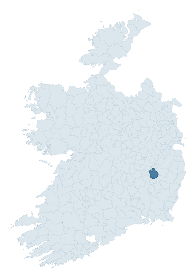
Where this barony sits in the Republic of Ireland
Geology and preservation
Bedrock geology shapes the landscape long before any settlement begins — controlling soil drainage, agricultural potential, the survival of upstanding monuments, and the preservation of buried archaeology. The figures below come from the Geological Survey Ireland 1:100,000 bedrock map.
The bedrock underlying Kilkea And Moone is predominantly granite (41% of the barony by area), with much of the rock dating to the Caledonian period. Granite weathers slowly and produces thin, acidic, often poorly-drained soils that historically limited arable agriculture but favoured pastoralism, upland settlement, and the construction of stone monuments. Granite-dominated landscapes typically carry fewer ringforts but a higher density of megalithic tombs, standing stones, and stone circles, which survive well against the resistant bedrock. A substantial secondary geology of limestone (28%) and calcareous greywacke (11%) adds further variety to the underlying landscape. With 7 distinct rock types mapped, the barony sits in the top third of ROI baronies for geological diversity (72nd percentile) — typically a sign of complex tectonic history or coastal mosaics of differing rock units.
Rock type composition
Largest mapped unit: Type 2 Equigranular Granite (Tullow Pluton) (21% of the barony)
Placename evidence
Logainm records 10 heritage-diagnostic placenames for Kilkea And Moone, a modest sample drawn predominantly from the townland record. The dominant stratum is early christian ecclesiastical. The most frequent diagnostic roots are cill- (3) and dún- (2). With a sample of this size the count should be treated as indicative rather than definitive.
Pre-Christian / Early Medieval Defensive
| Root | Count | Meaning |
|---|---|---|
| dún- | 2 | hilltop or promontory fort |
| lios- | 1 | ringfort or enclosure |
Early Christian Ecclesiastical
| Root | Count | Meaning |
|---|---|---|
| cill- | 3 | church (early) |
| díseart- | 2 | hermitage |
| gráinseach- | 2 | monastic farm / grange |
Other baronies in Kildare
About this profile
Click any section below to expand.
What is a barony?
A barony is a historic administrative unit in Ireland, broadly equivalent to an English hundred. The 280 baronies used here are from the OSi 2019 National Statutory Boundaries (generalised 20m), covering the 26 counties of the Republic of Ireland. Baronies derive from the Norman period, were formalised in the 17th century, and have not been redrawn for statistical purposes. They vary enormously in area, from compact urban baronies in Dublin to vast upland baronies in Connacht, and should not be compared by raw site count without accounting for area differences.
What counts as a site?
This profile combines three distinct heritage registers, each with its own definition of what constitutes a recordable site:
- Archaeological sites (NMS). The National Monuments Service Sites and Monuments Record (SMR) catalogues every known archaeological monument or site of archaeological interest in the Republic, from prehistoric burial mounds and ringforts to medieval churches and post-medieval defensive works. Inclusion does not require legal protection — only that the site has been identified, surveyed, and assessed as having archaeological value. A separate subset of these sites lies within a recorded protection zone, which gives them statutory protection under the National Monuments Acts.
- Listed buildings (NIAH). The National Inventory of Architectural Heritage records buildings of architectural, historical, archaeological, artistic, cultural, scientific, social, or technical interest. Each surveyed structure is appraised on a five-tier scale: International, National, Regional, Local, and Record-Only. The NIAH appraisal is informational rather than strictly statutory, but it underpins local-authority Record of Protected Structures (RPS) listings.
- Heritage placenames (Logainm). Logainm is the authoritative database of Irish placenames maintained by the Placenames Branch. This profile applies a heritage-diagnostic classifier to the Irish-language form of each townland name, flagging roots that signal defensive sites (ráth-, lios-, dún-, caiseal-, cathair-), ecclesiastical foundations (cill-, teampall-, domhnach-, mainistir-), prehistoric burial-ritual features (tuaim-, carn-, leaba-), or Norse-contact settlement (gall-). Townlands without one of these diagnostic roots are not flagged here — they may still carry historical significance, but that significance is not encoded in the name itself.
Editorial principles
The narrative sections of this profile follow several explicit principles:
- Evidential. Every claim about this barony’s heritage character is anchored in the underlying register data. Where a site count, a placename count, or a percentile rank is cited, it is computed from the source datasets at export time, not estimated.
- Comparative. Counts and metrics are reported alongside their percentile rank against the other 279 ROI baronies. A barony with 50 ringforts in absolute terms could be unusually high or unusually low depending on its size and regional context; percentile ranking removes that ambiguity.
- Transparent on limits. Where a register has known coverage gaps, survey biases, or data-quality issues that affect this barony’s figures, the profile flags them rather than presenting the numbers as definitive.
- No interpretation beyond what the data supports. The narrative does not speculate about historical events, social dynamics, or cultural meaning beyond what the recorded heritage and placename evidence directly attests.
Data caveats and limits
- NMS Sites and Monuments Record is the product of survey campaigns conducted at different intensities across different counties and decades. Some baronies have been surveyed more thoroughly than others, and absolute counts should be read in that light. Sites destroyed by development before survey are typically not represented; sites in heavily forested or upland terrain are sometimes under-recorded.
- NIAH coverage is broadly complete for the Republic of Ireland but the survey was conducted on a rolling county-by-county basis, and the most recent appraisal date varies. Buildings demolished or substantially altered after their original survey may still appear in the register; conversely, recent buildings of merit may not yet have been appraised.
- Logainm classification applies a deliberately conservative pattern-matching approach to the Irish-language townland forms. The classifier prioritises true positives over recall: a townland may carry a heritage signal that the classifier doesn’t recognise, particularly where the diagnostic root has been heavily anglicised or where the townland name draws on a less common term. The 60,000+ townland records and ~9,800 classified placenames give a substantial signal at barony scale, but individual townland names should be checked against Logainm directly for definitive interpretation.
- Period attribution. The chronological distribution reflects only those NMS sites that carry a recognised period attribution in the source data. Sites listed as “Unknown” period are excluded from the dated subset.
- Boundary changes. Some baronies have undergone minor boundary adjustments since their 19th-century definition; the OSi 2019 generalised boundaries used here are the current statutory definition and may differ slightly from historical maps in border areas.
- Bedrock geology is mapped at 1:100,000 scale, which means local variation within a barony — small pockets of different rock type, mineral veins, alluvium overlying bedrock — is generalised. The dominant-system and rocktype figures are area-weighted, so a barony reading “70% Carboniferous limestone” may still contain small but archaeologically important pockets of older or younger rock. Around 3% of GSI polygons do not match the lexicon and contribute no rocktype or system attribution.
Data sources
- National Monuments Service — Sites and Monuments Record (SMR) https://data.gov.ie/dataset/national-monuments-service-archaeological-survey-of-ireland
- National Inventory of Architectural Heritage (NIAH) https://data.gov.ie/dataset/national-inventory-of-architectural-heritage-niah-national-dataset
- Logainm — Placenames Database of Ireland https://www.logainm.ie/
- Ordnance Survey Ireland — National Statutory Barony Boundaries 2019 https://data-osi.opendata.arcgis.com/
- EURODEM — European Digital Elevation Model https://www.mapsforeurope.org/datasets/euro-dem
- ESA WorldCover https://esa-worldcover.org/en
- Geological Survey Ireland — 1:100,000 Bedrock Geology https://www.gsi.ie/en-ie/data-and-maps/Pages/Bedrock.aspx
Explore more: Search any of the 280 ROI baronies, browse by historical province, or read the methodology and data sources for the full Republic of Ireland Heritage Tool.