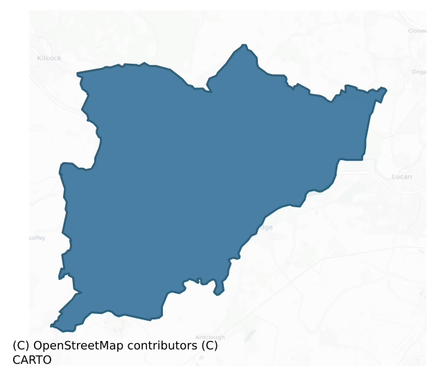
Salt North is a barony of County Kildare, in the historical province of Leinster (Irish: An Léim Thuaidh), covering 89 km² of land. The barony records 185 NMS archaeological sites and 264 NIAH listed buildings, placing it at around the 58th percentile among 280 ROI baronies for sites per km². This means it is in the upper half of all baronies for sites per km². Dated archaeological evidence runs from the Early Bronze Age through to the Post Medieval, spanning 6 of 9 archaeological periods, placing the barony in the 12th percentile among 280 ROI baronies for chronological depth. This means it is in the bottom fifth of all baronies for chronological depth. The largest dated subset of recorded sites dates to the Early Medieval.

Heritage at a glance
Percentile rankings throughout this profile compare each barony only against the other 279 Republic of Ireland baronies.
The recorded heritage of Salt North
The National Monuments Service Sites and Monuments Record (SMR) is the statutory inventory of archaeological sites for the Republic of Ireland, maintained by the Department of Tourism, Culture, Arts, Gaeltacht, Sport and Media. Sites recorded here include earthworks, ringforts, megalithic tombs, ecclesiastical remains, and post-medieval features; not every record is legally protected, but each is registered as a monument of archaeological interest.
The National Monuments Service records 185 archaeological sites in Salt North, putting it at the 58th percentile among 280 ROI baronies for sites per km². This means it is in the upper half of all baronies for sites per km². Of these, 161 (87%) fall within a recorded monument protection zone. The record is dominated by ecclesiastical sites — churches, graveyards, and holy wells (45 sites, 24% of the total), with defensive sites forming a substantial secondary presence (41 sites, 22%). The most diagnostically specific type is Church (13 records, 7% of the barony's NMS total) — compared to an ROI average of 4% across all baronies where this type occurs. Church is a building used for public Christian worship, of any date from c. 500 AD onwards. The broader 'Enclosure' classification — which catches unclassified ringforts and field enclosures — accounts for a further 21 records (11%) and reflects the difficulty of sub-classifying degraded earthworks from surface evidence alone. Across the barony's 89 km², this gives a recorded density of 2.09 sites per km².
Most common monument types
Hover or tap a monument type to see its definition.
| Type | Count |
|---|---|
| Enclosure a banked or ditched feature of uncertain type, used as a catch-all where the original function cannot be determined from surface evidence | 21 |
| Church a building used for public Christian worship, of any date from c. 500 AD onwards | 13 |
| Graveyard a burial area associated with a church, in use from the medieval period onwards | 12 |
| Ring-ditch a circular ditch under 20m across, often the ploughed-out remains of a barrow, ring-barrow or roundhouse | 12 |
| Ritual site – holy well a well or spring traditionally associated with a saint, often credited with healing properties; many trace earlier ritual origins but devotion is documented from the medieval period onwards | 9 |
| Ringfort – rath an earthen ringfort enclosed by a bank and external ditch — the most common Early Medieval farmstead, broadly dated 500–1000 AD | 7 |
Chronological distribution
The dated archaeological record for Salt North spans from the Early Bronze Age through to the Post Medieval, with activity attested across 6 of 9 archaeological periods. This is the 12th percentile across ROI baronies — a relatively narrow chronological band, with much of Irish prehistory not represented in the dated record. Every period from earliest to latest is represented in the record — an unbroken sequence of dated activity across the full chronological span. Activity concentrates most heavily in the Early Medieval (40 sites, 30% of dated material), with the Iron Age forming a secondary peak (37 sites, 28%). A further 52 recorded sites (28% of the overall NMS register for the barony) carry no period attribution — appearing as 'Unknown' in the bar chart below. This typically reflects either records that pre-date the standardised period vocabulary or sites awaiting specialist dating review, rather than a genuine absence of chronological evidence.
Sample of recorded monuments
Show 25 sample monuments (of 185 total)
A representative sample of 25 recorded monuments drawn from the barony’s 185 total NMS entries. Sites within a recorded monument protection zone and rarer site types are prioritised so the list shows a meaningful cross-section rather than only the most common type. Each entry shows the official Sites and Monuments Record reference number and the description published by the National Monuments Service.
Weir – fish
There was formerly a fishery on the Salmon Leap. This comprised an artifical obstruction across the course of the river. In 1207 King John granted Adam de Hereford 'all the salmon fishery of the salmon leap'; also in…
There was formerly a fishery on the Salmon Leap. This comprised an artifical obstruction across the course of the river. In 1207 King John granted Adam de Hereford 'all the salmon fishery of the salmon leap'; also in 1562 Elizabeth granted William Vernon 'two fishing places, called the Salmon Leap' (Went 1954, 55-56).
Compiled by: Geraldine Stout
Date of upload: 26 August 2011
Architectural feature
In the grounds of St Patricks College, Maynooth. An 18th century Church of Ireland schoolhouse contains a medieval doorway (Wth 1.03m; H 2.4m) which is chiefly of granite and has a segmented fluted arch of five…
In the grounds of St Patricks College, Maynooth. An 18th century Church of Ireland schoolhouse contains a medieval doorway (Wth 1.03m; H 2.4m) which is chiefly of granite and has a segmented fluted arch of five 'orders', and a medieval twin-light window with hood-moulding, of granite with limestone repairs. Both reputedly came from the Earl of Kildare's Council House (KD005-013—-) which formed part of the Maynooth castle complex (KD005-015—-) and which was demolished c. 1780, according to the Fourth Duke of Leinster (1891-5,321)
Compiled by: Gearóid Conroy
Date of upload: 10 June 2011
Standing stone
In open gently undulating pasture, c. 90m SE of a ringfort (KD006-006—-). Not recorded on the 1st ed. (1838) of the OS 6-inch map, but described in 1972 as a limestone boulder (dims. L 1.3m; T 0.5m) lying in the…
In open gently undulating pasture, c. 90m SE of a ringfort (KD006-006—-). Not recorded on the 1st ed. (1838) of the OS 6-inch map, but described in 1972 as a limestone boulder (dims. L 1.3m; T 0.5m) lying in the field, but of which there was no visible trace in 1985 (SMR file). Fitzgerald (1903-5, 4) translates the townland name Carton as, ' "Baile an Cairthe" the town of the Pillar Stone' .
Compiled by: Gearóid Conroy
Date of upload: 10 June 2011
Ogham stone
Discovered in 1902 by Lord Walter Fitzgerald (1903-5, 26) in the NE sector of Donaghmore graveyard (KD006-005004-), where, according to O'Hanluain (1935-45, 170), it marked an O'Farrell family grave. Macalister (1945,…
Discovered in 1902 by Lord Walter Fitzgerald (1903-5, 26) in the NE sector of Donaghmore graveyard (KD006-005004-), where, according to O'Hanluain (1935-45, 170), it marked an O'Farrell family grave. Macalister (1945, 130-1, no. 26) recorded the stone's dimensions (0.76 x 0.36 x 0.23m, converted from Macalister) and read the inscription as: NETTAVRECC [KOI] MAQI MUCCOI TRENALUGGO. McManus (1997, 66, 79) suggested that there was enough room for a more likely NETTAVROICC or NETTAVROECC and that Macalister's KOI was doubtful. The stone is now in the National Museum of Ireland (DU018-173—-).
Compiled by: Nora White
Date of upload: 14 September 2016
Religious house – unclassified
In the N sector of a graveyard (KD006-007002-). A short length of ivy-clad wall (dims. L 2.5m N-S; H 4m; T 1m) built of mortared, irregularly coursed limestone blocks may be the remains of the E-gable of a church…
In the N sector of a graveyard (KD006-007002-). A short length of ivy-clad wall (dims. L 2.5m N-S; H 4m; T 1m) built of mortared, irregularly coursed limestone blocks may be the remains of the E-gable of a church (KD006-007001-) described as a 'chapel of ease' in the 1654 Civil Survey, although the OSL (Herity 2002, 18) record it as 'an old wall which belonged to a Nunnery (KD006-007003-) that was there formerly', an assertion that may be supported by the existence of a possible holy well (KD006-011—-) called 'Nun's Well' c. 240m to the SSW. A nunnery is not recorded by Gwynn and Hadcock (1970) at this location.
Compiled by: Gearóid Conroy
Date of upload: 10 June 2011
Round tower
National Monument No. 70. In the S sector of a roadside graveyard (KD010-014003-), and part of an early monastic foundation (KD010-014—-). A roofless but otherwise well-preserved, five storied, tower (ext. diam.…
National Monument No. 70. In the S sector of a roadside graveyard (KD010-014003-), and part of an early monastic foundation (KD010-014—-). A roofless but otherwise well-preserved, five storied, tower (ext. diam. 4.96m; int diam. 2.54m; H 19.8m) is built of roughly coursed, poor quality, slatey limestone (wall T 1.02m through doorway) on a slightly projecting plinth (projects 0.1m). A round, three-stone arched doorway (H 1.57m; ext. Wth at base 0.66m: ext. Wth at springing 0.58m; H of sill above ground level 3.5m) with a plain decorative moulding faces SSE and is predominantly composed of granite, with some limestone in the E jamb; a mix of materials interpreted by Lennox-Barrow (1979, 124-6) as an uncompleted attempt to replace an original limestone doorway with one of granite. A weathered stone above the centre stone of the doorway's arch may have been decorated with a human head. Internally the floor levels are marked by set-backs in the wall face (Wth 0.05-0.01m) which would have carried wooden flooring. The tower is lit by three windows with inclined jambs and square tops; one on the second floor looking W, the second on the third floor, above the doorway, looking SSE and the third at probable fourth-floor level looking WNW. A ring of small, square putlock holes is visible just below the top of the tower. In the 19th century, a doorway was inserted at ground-floor level to allow coal to be stored for heating the nearby church (KD010-014005-), and has been blocked up…
Chapel
National Monument No. 578. At the W edge of a graveyard (KD010-014003-) which is part of an early monastic site (KD010-014—-). Named 'RC Chapel in ruins' on the 1st ed. (1838) of the OS 6-inch map and indicated as a…
National Monument No. 578. At the W edge of a graveyard (KD010-014003-) which is part of an early monastic site (KD010-014—-). Named 'RC Chapel in ruins' on the 1st ed. (1838) of the OS 6-inch map and indicated as a rectangular structure (est. dims. L c. 30m NNE-SSW; Wth c. 10m). The site is not recorded on the latest ed. (1911) of the OS 6-inch map and is not visible at ground level. It may have been an 18th/19th century church. Geophysical survey (M. Byrne Unpublished MA thesis, NUI Maynooth, 2005) revealed possible subsurface remains of this church.
Compiled by: Gearóid Conroy
Date of upload: 10 June 2011
Bawn
Some 6m S of a tower house (KD010-022001-) and separated from it by a later building, a short portion of wall (L 5.8m E-W; H 3.1m; T 1m) built of roughly coursed rubble masonry contains a blocked loop, and may be the…
Some 6m S of a tower house (KD010-022001-) and separated from it by a later building, a short portion of wall (L 5.8m E-W; H 3.1m; T 1m) built of roughly coursed rubble masonry contains a blocked loop, and may be the remains of a bawn wall. A tall gate pier at its W end is not bonded to the wall and appears to be a later feature.
Compiled by: Gearóid Conroy
Date of upload: 10 June 2011
Designed landscape – folly
An extravagant and monumental folly structure closing a 2 mile vista from the garden front of Castletown House. Built c. 1740, it consists of a central obelisk set upon a series of superimposed arches which are also…
An extravagant and monumental folly structure closing a 2 mile vista from the garden front of Castletown House. Built c. 1740, it consists of a central obelisk set upon a series of superimposed arches which are also surmounted by carved stone pineapples and eagles on pedestals. The overall height of the structure is approx 140ft and its design is attributed to the architect Richard Castle. The folly was commissioned by Katherine Conolly, widow of William Conolly, Speaker of the Irish House of Commons, to commemorate her husband and provided relief work for local labourers during a severe winter. Mariga Guinness, a founding member of the Irish Georgian Society, was buried below the central arch in 1989. The 'Conolly Folly' is now a National Monument (No. 681) in State Ownership.
Compiled by: Gearóid Conroy
Date of upload: 10 June 2011
Ritual site – holy tree/bush
Shearman (1874-5, 306), records that a holy well (KD010-024—-) was 'still frequented by pilgrims who hang up votive offerings of rags on an ancient thorn which overhangs the well'. The well lies in a small thicket on…
Shearman (1874-5, 306), records that a holy well (KD010-024—-) was 'still frequented by pilgrims who hang up votive offerings of rags on an ancient thorn which overhangs the well'. The well lies in a small thicket on the S-roadside at the N-foot of St Patrick's Hill (OD 308 feet). None of the bushes/trees in the vicinity appear to carry votive offerings.
Compiled by: Gearóid Conroy
Date of upload: 10 June 2011
Wall monument
In the N wall of the chancel arch in St Mary's Church (KD011-004003-). According to Bradley et al. (1986 vol. 3, 317), two rectangular plaques are set in an architectural frame. The upper stone (dims. H 0.58m; Wth…
In the N wall of the chancel arch in St Mary's Church (KD011-004003-). According to Bradley et al. (1986 vol. 3, 317), two rectangular plaques are set in an architectural frame. The upper stone (dims. H 0.58m; Wth 0.41m) bears the White and Moore coat of arms, while the lower stone (dims. H 0.44m; Wth 0.92m) bears a badly incised inscription, with the date 1664.
Compiled by: Gearóid Conroy
Date of upload: 10 June 2011
Burial mound
In 2010, during archaeological monitoring (Excavation Licence No. 10E0414) of ongoing restoration works commissioned by the Office of Public Works within Castletown Demesne, a prehistoric site was uncovered in a trench…
In 2010, during archaeological monitoring (Excavation Licence No. 10E0414) of ongoing restoration works commissioned by the Office of Public Works within Castletown Demesne, a prehistoric site was uncovered in a trench for a gas pipeline and services ducting traversing the front lawn of the Castletown House. An area measuring approximately 8m by 9m was opened in order to clarify the nature and context of the find. The site contained a crouched inhumation burial and a crushed prehistoric vessel which were fully recorded and removed (designated KD011-060001-). The burial appears to fit with the 'Bowl Tradition' of Bronze Age burial of the later 3rd Millennium BC. The service trench had truncated six other pit burials (designated KD011-060002-, KD011-060003-, KD011-060004-, KD011-060005-, KD011-060006- and KD011-060007-). They were recorded in situ and were not subjected to any further disturbance. The pits were sub-circular (diams. 1-2m: D 0.3-0.6m), and, visible in section, filled with quantities of cremated bone. Their morphologies and fills have a similar character to the crouched inhumation. Four sherds of prehistoric pottery were also found. Provisional conclusions are that the site represents a cemetery of pit burials. A circular concentration of compact stony material (diam. 3m) to the north-east of the excavated burial may be the surviving core of a low mound, otherwise levelled (KD011-060—–). Significantly two of the smaller pits (diam. 1m) are set into the edges…
House – prehistoric
In 1996, archaeological excavation (Licence No. 96E0391 ext.) of the whole of the interior of the keep of Maynooth Castle (KD005-015—-) was undertaken for Dúchas, The Heritage Service, before the development of the…
In 1996, archaeological excavation (Licence No. 96E0391 ext.) of the whole of the interior of the keep of Maynooth Castle (KD005-015—-) was undertaken for Dúchas, The Heritage Service, before the development of the ground floor as an exhibition space. Seven main phases of occupation of the site were evidenced.
Part of a rectangular prehistoric building (designated KD005-015001-) was the stratigraphically earliest structure uncovered. No finds were associated with it; however, a stone axe head and unfinished macehead, as well as a number of waste flakes of flint, were uncovered in early medieval contexts and may derive from the structure.
At least two small post-and-wattle round houses (designated KD005-015002- and KD005-015003-), each c. 5m in diameter, were constructed over the prehistoric remains and are probably of early medieval date. No datable finds were recovered from them, but excellent carbon samples were retrieved from their hearths and post-holes. The latest of the round houses (designated KD005-015003-) appears to have had a curving wooden stockade added to one side of it. The house would appear to be contemporary with the beginning of the cultivation of the site, which was evidenced by regularly spaced shallow furrows. The cultivation later overwhelmed the house and continued until the arrival of the Anglo-Normans.
The site appears to have fallen into Norman hands in around 1175. The remains of a mound of sod c. 1m high were uncovered dating to the beginn…
Font
In the ground floor of the tower at the W-end of Leixlip church (KD011-004003-). A large rectangular font (dims. L 0.68m; Wth 0.66m; H 0.36m) contains a circular basin (diam. 0.47m; D 0.22m) which lacks a drain hole.…
In the ground floor of the tower at the W-end of Leixlip church (KD011-004003-). A large rectangular font (dims. L 0.68m; Wth 0.66m; H 0.36m) contains a circular basin (diam. 0.47m; D 0.22m) which lacks a drain hole. Coated in black gloss paint (Bradley et al. 1986 vol. 3, 318).
Compiled by: Gearóid Conroy
Date of upload: 10 June 2011
Barrow – ring-barrow
Cropmark of circular-shaped trivallate ditched enclosure/barrow (approx. ext. diam. 30m) visible on Google earth aerial imagery.
Compiled by: Caimin O'Brien based on details kindly provided by Edward…
Cropmark of circular-shaped trivallate ditched enclosure/barrow (approx. ext. diam. 30m) visible on Google earth aerial imagery.
Compiled by: Caimin O'Brien based on details kindly provided by Edward O'Riordan.
See attached image taken from Google Earth aerial photographs taken 28/06/2018.
Date of upload: 6 November 2018
Road – road/trackway
Visible on a 1970 aerial photograph (CUCAP BDR 31) as the cropmark of a possible trackway defined by two parallel fosses (est. L. c. 200m ESE-WNW) running through an enclosure (KD005-010—-) and possibly post-dating…
Visible on a 1970 aerial photograph (CUCAP BDR 31) as the cropmark of a possible trackway defined by two parallel fosses (est. L. c. 200m ESE-WNW) running through an enclosure (KD005-010—-) and possibly post-dating it, and also possibly associated with a small enclosure (KD005-010—-) to the N and a field-system (KD005-012—-) immediately to the S. By 1985 the site had been overlain by earthen landscaping mounds (SMR file). Area is visible on a recent aerial photograph (OSi Orthophoto 2005) and is built upon with modern housing.
Compiled by: Gearóid Conroy
Date of upload: 10 June 2011
Building
In the grounds of St Patricks College, Maynooth. The site of the Earl of Kildare's Council House which formed part of the Maynooth castle (KD005-015—-) complex and which was demolished c. 1780, according to the Fourth…
In the grounds of St Patricks College, Maynooth. The site of the Earl of Kildare's Council House which formed part of the Maynooth castle (KD005-015—-) complex and which was demolished c. 1780, according to the Fourth Duke of Leinster (1891-5, 321). A nearby 18th century Church of Ireland schoolhouse contains architectural features (KD005-014—-) including a medieval doorway and twin-light window which reputedly came from the Council House.
Compiled by: Gearóid Conroy
Date of upload: 10 June 2011
Castle – Anglo-Norman masonry castle
National Monument No. 485. The Manor of Maynooth was granted by Strongbow to Maurice Fitzgerald who erected Maynooth castle, probably in the late-1180s. At the beginning of the 14th century, the castle became principal…
National Monument No. 485. The Manor of Maynooth was granted by Strongbow to Maurice Fitzgerald who erected Maynooth castle, probably in the late-1180s. At the beginning of the 14th century, the castle became principal residence of Kildare Geraldines. It was altered/enlarged by John (the sixth Earl) in 1426. In 1518, the ninth Earl requested a licence to found and endow a college. In 1540, the dissolution documents relating to the Franciscan Friary in Clane (KD014-026005-) noted that the church, chancel and part of the dormitory there had been destroyed, and the building material was reused in the repair of the King's castle in Maynooth. (Gwynn and Hadcock 1970, 245). Kilkea Castle (KD037-017002-) had been the principal seat of the family from the time of the 1641 rebellion, when Maynooth Castle was dismantled (JKAS 1891-5, 222-32). The remains consist of a keep, a rectangular gatehouse, SE tower, postern, parts of the great hall and gallery. Parts of a manorial church associated with the castle are incorporated in the nearby St Mary's Church of Ireland church (KD005-016). The rectangular keep (dims. L c. 22.6m N-S; Wth c. 19.4m E-W; max. wall T c. 2.1m) has an entrance 6.3m above ground level. There are two barrel-vaulted chambers on the ground floor, and intramural passages survive in three of its walls. The SE tower was extensively altered during restoration works and has an entrance in the N side. Internally, the floors appear to have been accessed via ladders and the…
Road – road/trackway
Possibly the original access route to/from an early monastic site (KD011-002—-) and visible on three aerial photographs (CUCAP AHK 11 (1963); AYR 52 (1969); BDU 45 (1970)). A broad trackway (Wth 6m N-S) is defined…
Possibly the original access route to/from an early monastic site (KD011-002—-) and visible on three aerial photographs (CUCAP AHK 11 (1963); AYR 52 (1969); BDU 45 (1970)). A broad trackway (Wth 6m N-S) is defined along it's N and S sides by a low, intermittent, earthen bank (av. Wth 4m along N; 2.2m along S; H 0.2m) which is reduced to a scarp (H 0.2m) in several places. It is traceable E-W (L 38m) and is truncated at E by the outer enclosure (KD011-002001-) of the possible early monastic site, which suggests that it may predate that enclosure and belong to an earlier phase of the monastery. At it's W end it stops at a modern field boundary and there is no obvious visible surface trace of the monument beyond to the W.
Compiled by: Gearóid Conroy
Date of upload: 10 June 2011
Historic town
Located at the confluence of the E-flowing River Liffey and its tributary, the S-flowing Rye Water. According to Bradley et al. (1986 vol. 3, 304-305), the existence of a Scandinavian placename 'Lex-hlaup' / 'salmon…
Located at the confluence of the E-flowing River Liffey and its tributary, the S-flowing Rye Water. According to Bradley et al. (1986 vol. 3, 304-305), the existence of a Scandinavian placename 'Lex-hlaup' / 'salmon leap', suggests a Viking settlement. In the late-12th/early-13th century, Leixlip was also known by the name 'Ernia' or 'Hernie', possibly derived from An Urnaidhe, meaning oratory, which may also indicate the presence of a pre-Norman ecclesiastical site. The earliest definite evidence for settlement occurs in the late-12th century when Adam De Hereford established a castle and borough and granted the church and burgage to St Thomas' Abbey. Subsequently another burgage was given to St. Mary's Abbey in Dublin. The borough was looted and burnt by Edward Bruce's army in 1317, but otherwise seems to have remained relatively undisturbed. A population of 100 was recorded in the census of 1659. The town was confined to a narrow strip of land between the Liffey on the S, a high ridge on the N, and the Rye Water on the W, with the main street running roughly E-W along the centre of this strip of ground. A burgage plot pattern survives on the N and S of Main Street. The settlement included an early castle (KD011-004002-), a church (KD011-004003-) and graveyard (KD011-004004-), and a tower house (KD011-004005-), while archaeological excavation has uncovered medieval deposits to the N of Main Street (KD011-004007-).
Compiled by: Gearóid Conroy
Date of upload: 10 June…
Castle – Anglo-Norman masonry castle
Just S of the confluence of the River Liffey and its tributary the Rye Water. According to Bradley et al. (1986 vol. 3, 309-311), Adam de Hereford's grants to St. Thomas' Abbey, which mention his castle of 'Hernie' or…
Just S of the confluence of the River Liffey and its tributary the Rye Water. According to Bradley et al. (1986 vol. 3, 309-311), Adam de Hereford's grants to St. Thomas' Abbey, which mention his castle of 'Hernie' or 'Ernia', can be dated to before 1212. While the original castle may have been a motte, by the time of the grants the castle had a grange and a chapel attached. Around 1252, the manor of Leixlip passed from Adam's son, Stephen, to the Pippard family. In 1302, Ralph Pippard granted all his manors in Ireland to the King, and in 1303-4, monies were spent on constructing a kitchen in the castle, building a limekiln to produce lime for works on the castle, breaking stone and cutting wood. In 1331, the King gave John de Grauntsete the custody of the manor and castle of Leixlip for ten years, but in 1336, they were given to Roger Outlaw, prior of Kilmainham, and they were probably held by the Hospital of St. John of Jerusalem for more than a century, until Leixlip passed out of the Order's hands sometime between 1455 and 1479-80, when it was granted to Thomas Daniel, Lord of Rathwire. In 1496, Henry VII granted Leixlip to Gearóid Mór, 8th Earl of Kildare, but it was forfeited in 1536, after the rebellion of Silken Thomas. Subsequently it was granted to Matthew King, John Alen and William Vernon. In 1507, it was granted to Sir Nicholas White and remained in his family until the 18th c. The castle, an amalgam of several building phases is still lived in. While Guinness…
Ringfort – unclassified
On a short, gentle, E-facing pasture slope. Visible on aerial photographs (GSI 467, 468) as the cropmark of a fosse enclosing an oval area (est. max. diams. c. 70m N-S; c. 40m E-W), but not visible at ground level. The…
On a short, gentle, E-facing pasture slope. Visible on aerial photographs (GSI 467, 468) as the cropmark of a fosse enclosing an oval area (est. max. diams. c. 70m N-S; c. 40m E-W), but not visible at ground level. The morphology and siting suggest that it may have been a ringfort, some sub-surface remains of which may survive intact.
Compiled by: Gearóid Conroy
Date of upload: 10 June 2011
Mound
At the top of a gentle, E-facing pasture slope. This fairly high mound (max H 3.5m at E; min H 1.4m at W) has a circular base (diam. 16.5m) and a very small, oval, upper surface (diams. 1.5m E-W; 0.7m N-S). It is…
At the top of a gentle, E-facing pasture slope. This fairly high mound (max H 3.5m at E; min H 1.4m at W) has a circular base (diam. 16.5m) and a very small, oval, upper surface (diams. 1.5m E-W; 0.7m N-S). It is composed mainly of earth but some stone is visible near the top. A level berm (Wth 2.2m) occurs half-way up the side of the monument between N and E.
Compiled by: Gearóid Conroy
Date of upload: 10 June 2011
Historic town
According to Bradley et al. (1986, Vol. 2, 126-36), evidence for pre-Norman settlement consists of the placename Cill Droiched ('the church of the bridge'), traditional associations with St Mochua, and traces of a…
According to Bradley et al. (1986, Vol. 2, 126-36), evidence for pre-Norman settlement consists of the placename Cill Droiched ('the church of the bridge'), traditional associations with St Mochua, and traces of a possible early ecclesiastical enclosure. The village was known as Kildrought until the 18th c. Celbridge formed part of the 'cantred of Offelan nearest Dublin' granted by Strongbow to Adam De Hereford before 1176. Adam granted Celbridge ('Kildroch') to his brother John, who was in turn succeeded by his son Thomas, on whose death, before 1224, Celbridge passed to his son-in-law Milo de Rochford. The Rochfords held Celbridge until the mid-14th c. Although the earliest evidence for the existence of a borough occurs in 1401, there was clearly a significant settlement there by 1314 when Henry le Waleys was charged with breaking the 'doors of houses in the town of Kildroght' and taking geese, hens, bread, and beer (Wood et al. 1956, 318). Around 1387-9, John Rout and Richard Arblaster, chaplains, were given royal licence to enfeoff Maurice FitzThomas, earl of Kildare, with the manor of Kildroght. The manor was forfeited after the rebellion of Silken Thomas, and in 1536, it was granted to John Alen, Master of the Rolls. By 1554, it had been restored to the Kildares when the earl requested the Lord Deputy to confirm the manor of Castletown (i.e. the town of the castle of Celbridge) to Gerald Sutton, who was later to forfeit it because of his part in the Baltinglass rebel…
Enclosure
Visible on as 1970 aerial photograph (CUCAP BDR 31) as the cropmark of a fosse enclosing an approximately circular area (est. max. diam. c. 40m), crossed by a possible trackway (KD005-011002-), and possibly associated…
Visible on as 1970 aerial photograph (CUCAP BDR 31) as the cropmark of a fosse enclosing an approximately circular area (est. max. diam. c. 40m), crossed by a possible trackway (KD005-011002-), and possibly associated with a small enclosure (KD005-010—-) immediately to the N, and with a possible field-system (KD005-012—-) immediately to the S. By 1985 the site had been overlain by earthen landscaping mounds (SMR file). Area is visible on a recent aerial photograph (OSi Orthophoto 2005) and is built on with modern housing.
Compiled by: Gearóid Conroy
Date of upload: 10 June 2011
Listed buildings
The National Inventory of Architectural Heritage (NIAH) is a state survey appraising buildings of architectural, historical, archaeological, artistic, cultural, scientific, social, or technical interest. Each surveyed structure receives a rating from International (the highest, for buildings of European importance) through National, Regional, Local, and Record-Only.
The NIAH records 264 listed buildings in Salt North, the 85th percentile across ROI baronies for listed-building density. Among these, 8 are graded National — buildings of interest to the whole of Ireland rather than only its region. The Republic holds 937 National-graded buildings in total, so this barony accounts for around 1% of the national total. Construction dates concentrate most heavily in the Early Georgian (1700-1800) period. The most-recorded building type is house (142 examples, 54% of the listed stock).
Terrain and environment
Mean elevation across the barony is 64m — the 25th percentile among 280 ROI baronies for elevation. This means it is in the bottom third of all baronies for elevation. This is a relatively low-lying landscape by ROI standards. Elevation matters for heritage because higher-altitude baronies typically favour defensive monuments — ringforts and hilltop forts placed on prominent ground — while lowland baronies are more likely to carry the dense settlement and church networks of intensive agricultural landscapes. Mean slope is 2.4° — the 22nd percentile among 280 ROI baronies for slope. This means it is in the bottom third of all baronies for slope. This is broadly flat terrain, the kind of landscape best suited to intensive agriculture. Slope is a key control on both land use and archaeological preservation: steep ground resists ploughing and tends to preserve earthworks intact, while gentle slopes favour intensive cultivation that damages or destroys surface archaeology over time. The Topographic Wetness Index averages 11.7, the 82nd percentile among 280 ROI baronies for wetness. This means it is in the top fifth of all baronies for wetness. This is wet, slow-draining ground by ROI standards — the kind of landscape that may carry waterlogged archaeological sites of unusual preservation value. Drainage matters for heritage because poorly-drained ground preserves organic archaeology (wooden trackways, leather, textiles, and on rare occasions human remains) far better than free-draining soil; well-drained ground favours arable use but destroys organic material rapidly. Urban land covers 9% of the barony (the 94th percentile among 280 ROI baronies for urban cover. This means it is in the top tenth of all baronies for urban cover). Heavy urban coverage compresses heritage analysis: many archaeological features have been buried or destroyed by development, but the surviving record is concentrated in protected city-centre cores, and the NIAH listed-buildings count is typically high. The land-cover mosaic combines improved grassland (56%), arable farmland (19%), and woodland (15%), giving a mixed agricultural and semi-natural landscape. In overall character, this is low-lying, gently-sloping terrain — characteristic of Ireland's central plain and coastal lowlands, with land use dominated by improved grassland.
Terrain measurements
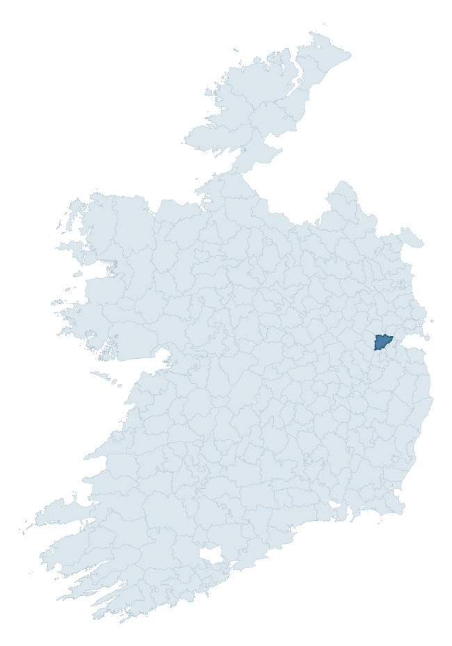
Where this barony sits in the Republic of Ireland
Geology and preservation
Bedrock geology shapes the landscape long before any settlement begins — controlling soil drainage, agricultural potential, the survival of upstanding monuments, and the preservation of buried archaeology. The figures below come from the Geological Survey Ireland 1:100,000 bedrock map.
The bedrock underlying Salt North is predominantly limestone (90% of the barony by area), laid down during the Carboniferous period (100% by area, around 359 to 299 million years ago). Limestone is the most heritage-rich bedrock in Ireland. It supports fertile, well-drained soils that favoured dense Early Medieval settlement and Norman manorial agriculture, and it weathers into karst features — sinkholes, caves, swallow holes, and souterrains — that frequently carry archaeology. Where peat overlies limestone, organic preservation can be exceptional. The single largest mapped unit is the Lucan Formation (58% of the barony's bedrock). With only 2 distinct rock types mapped, the barony is geologically uniform compared to the rest of the Republic (8th percentile for diversity) — a single coherent bedrock landscape.
Rock type composition
Largest mapped unit: Lucan Formation (58% of the barony)
Placename evidence
Logainm records 5 heritage-diagnostic placenames for Salt North, a modest sample drawn predominantly from the townland record. The dominant stratum is early christian ecclesiastical. The most frequent diagnostic roots are cill- (4) and domhnach- (1). With a sample of this size the count should be treated as indicative rather than definitive.
Early Christian Ecclesiastical
| Root | Count | Meaning |
|---|---|---|
| cill- | 4 | church (early) |
| domhnach- | 1 | pre-Patrician or earliest Patrician church |
Other baronies in Kildare
About this profile
Click any section below to expand.
What is a barony?
A barony is a historic administrative unit in Ireland, broadly equivalent to an English hundred. The 280 baronies used here are from the OSi 2019 National Statutory Boundaries (generalised 20m), covering the 26 counties of the Republic of Ireland. Baronies derive from the Norman period, were formalised in the 17th century, and have not been redrawn for statistical purposes. They vary enormously in area, from compact urban baronies in Dublin to vast upland baronies in Connacht, and should not be compared by raw site count without accounting for area differences.
What counts as a site?
This profile combines three distinct heritage registers, each with its own definition of what constitutes a recordable site:
- Archaeological sites (NMS). The National Monuments Service Sites and Monuments Record (SMR) catalogues every known archaeological monument or site of archaeological interest in the Republic, from prehistoric burial mounds and ringforts to medieval churches and post-medieval defensive works. Inclusion does not require legal protection — only that the site has been identified, surveyed, and assessed as having archaeological value. A separate subset of these sites lies within a recorded protection zone, which gives them statutory protection under the National Monuments Acts.
- Listed buildings (NIAH). The National Inventory of Architectural Heritage records buildings of architectural, historical, archaeological, artistic, cultural, scientific, social, or technical interest. Each surveyed structure is appraised on a five-tier scale: International, National, Regional, Local, and Record-Only. The NIAH appraisal is informational rather than strictly statutory, but it underpins local-authority Record of Protected Structures (RPS) listings.
- Heritage placenames (Logainm). Logainm is the authoritative database of Irish placenames maintained by the Placenames Branch. This profile applies a heritage-diagnostic classifier to the Irish-language form of each townland name, flagging roots that signal defensive sites (ráth-, lios-, dún-, caiseal-, cathair-), ecclesiastical foundations (cill-, teampall-, domhnach-, mainistir-), prehistoric burial-ritual features (tuaim-, carn-, leaba-), or Norse-contact settlement (gall-). Townlands without one of these diagnostic roots are not flagged here — they may still carry historical significance, but that significance is not encoded in the name itself.
Editorial principles
The narrative sections of this profile follow several explicit principles:
- Evidential. Every claim about this barony’s heritage character is anchored in the underlying register data. Where a site count, a placename count, or a percentile rank is cited, it is computed from the source datasets at export time, not estimated.
- Comparative. Counts and metrics are reported alongside their percentile rank against the other 279 ROI baronies. A barony with 50 ringforts in absolute terms could be unusually high or unusually low depending on its size and regional context; percentile ranking removes that ambiguity.
- Transparent on limits. Where a register has known coverage gaps, survey biases, or data-quality issues that affect this barony’s figures, the profile flags them rather than presenting the numbers as definitive.
- No interpretation beyond what the data supports. The narrative does not speculate about historical events, social dynamics, or cultural meaning beyond what the recorded heritage and placename evidence directly attests.
Data caveats and limits
- NMS Sites and Monuments Record is the product of survey campaigns conducted at different intensities across different counties and decades. Some baronies have been surveyed more thoroughly than others, and absolute counts should be read in that light. Sites destroyed by development before survey are typically not represented; sites in heavily forested or upland terrain are sometimes under-recorded.
- NIAH coverage is broadly complete for the Republic of Ireland but the survey was conducted on a rolling county-by-county basis, and the most recent appraisal date varies. Buildings demolished or substantially altered after their original survey may still appear in the register; conversely, recent buildings of merit may not yet have been appraised.
- Logainm classification applies a deliberately conservative pattern-matching approach to the Irish-language townland forms. The classifier prioritises true positives over recall: a townland may carry a heritage signal that the classifier doesn’t recognise, particularly where the diagnostic root has been heavily anglicised or where the townland name draws on a less common term. The 60,000+ townland records and ~9,800 classified placenames give a substantial signal at barony scale, but individual townland names should be checked against Logainm directly for definitive interpretation.
- Period attribution. The chronological distribution reflects only those NMS sites that carry a recognised period attribution in the source data. Sites listed as “Unknown” period are excluded from the dated subset.
- Boundary changes. Some baronies have undergone minor boundary adjustments since their 19th-century definition; the OSi 2019 generalised boundaries used here are the current statutory definition and may differ slightly from historical maps in border areas.
- Bedrock geology is mapped at 1:100,000 scale, which means local variation within a barony — small pockets of different rock type, mineral veins, alluvium overlying bedrock — is generalised. The dominant-system and rocktype figures are area-weighted, so a barony reading “70% Carboniferous limestone” may still contain small but archaeologically important pockets of older or younger rock. Around 3% of GSI polygons do not match the lexicon and contribute no rocktype or system attribution.
Data sources
- National Monuments Service — Sites and Monuments Record (SMR) https://data.gov.ie/dataset/national-monuments-service-archaeological-survey-of-ireland
- National Inventory of Architectural Heritage (NIAH) https://data.gov.ie/dataset/national-inventory-of-architectural-heritage-niah-national-dataset
- Logainm — Placenames Database of Ireland https://www.logainm.ie/
- Ordnance Survey Ireland — National Statutory Barony Boundaries 2019 https://data-osi.opendata.arcgis.com/
- EURODEM — European Digital Elevation Model https://www.mapsforeurope.org/datasets/euro-dem
- ESA WorldCover https://esa-worldcover.org/en
- Geological Survey Ireland — 1:100,000 Bedrock Geology https://www.gsi.ie/en-ie/data-and-maps/Pages/Bedrock.aspx
Explore more: Search any of the 280 ROI baronies, browse by historical province, or read the methodology and data sources for the full Republic of Ireland Heritage Tool.