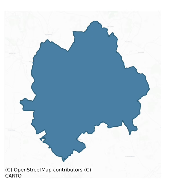
Fassadinin is a barony of County Kilkenny, in the historical province of Leinster (Irish: Fásach an Deighnín), covering 276 km² of land. The barony records 511 NMS archaeological sites and 180 NIAH listed buildings, placing it at around the 49th percentile among 280 ROI baronies for sites per km². This means it is in the lower half of all baronies for sites per km². Dated archaeological evidence runs from the Neolithic through to the Modern, spanning 8 of 9 archaeological periods, placing the barony in the 88th percentile among 280 ROI baronies for chronological depth. This means it is in the top fifth of all baronies for chronological depth. The largest dated subset of recorded sites dates to the Iron Age. Logainm flags 34 placenames in the barony as carrying a recognised heritage root; the largest share — around 50% — are names associated with pre-christian defensive.

Heritage at a glance
Percentile rankings throughout this profile compare each barony only against the other 279 Republic of Ireland baronies.
The recorded heritage of Fassadinin
The National Monuments Service Sites and Monuments Record (SMR) is the statutory inventory of archaeological sites for the Republic of Ireland, maintained by the Department of Tourism, Culture, Arts, Gaeltacht, Sport and Media. Sites recorded here include earthworks, ringforts, megalithic tombs, ecclesiastical remains, and post-medieval features; not every record is legally protected, but each is registered as a monument of archaeological interest.
The National Monuments Service records 511 archaeological sites in Fassadinin, putting it at the 49th percentile among 280 ROI baronies for sites per km². This means it is in the lower half of all baronies for sites per km². Protection coverage is near-universal — 489 sites (96%) fall within a recorded monument protection zone, indicating an extensively surveyed landscape. The record is dominated by defensive sites — ringforts, enclosures, hillforts, and stone forts (189 sites, 37% of the total), with burial and ritual monuments forming a substantial secondary presence (90 sites, 18%). The most diagnostically specific type is Ring-ditch (78 records, 15% of the barony's NMS total) — compared to an ROI average of 6% across all baronies where this type occurs. Ring-ditch is a circular ditch under 20m across, often the ploughed-out remains of a barrow, ring-barrow or roundhouse. The broader 'Enclosure' classification — which catches unclassified ringforts and field enclosures — accounts for a further 115 records (23%) and reflects the difficulty of sub-classifying degraded earthworks from surface evidence alone. Other significant types include Fulacht fia (52) — a horseshoe-shaped Bronze Age burnt mound built around a sunken trough beside a water source, traditionally interpreted as a cooking site. Across the barony's 276 km², this gives a recorded density of 1.85 sites per km².
Most common monument types
Hover or tap a monument type to see its definition.
| Type | Count |
|---|---|
| Enclosure a banked or ditched feature of uncertain type, used as a catch-all where the original function cannot be determined from surface evidence | 115 |
| Ring-ditch a circular ditch under 20m across, often the ploughed-out remains of a barrow, ring-barrow or roundhouse | 78 |
| Fulacht fia a horseshoe-shaped Bronze Age burnt mound built around a sunken trough beside a water source, traditionally interpreted as a cooking site | 52 |
| Church a building used for public Christian worship, of any date from c. 500 AD onwards | 30 |
| Graveyard a burial area associated with a church, in use from the medieval period onwards | 26 |
| Ringfort – rath an earthen ringfort enclosed by a bank and external ditch — the most common Early Medieval farmstead, broadly dated 500–1000 AD | 23 |
| Castle – unclassified a castle whose form cannot be precisely classified, dating somewhere between the late 12th and 16th centuries | 16 |
| Field system a group of related fields forming a coherent agricultural landscape, of any date from the Neolithic onwards | 13 |
Chronological distribution
The dated archaeological record for Fassadinin spans from the Neolithic through to the Modern, with activity attested across 8 of 9 archaeological periods. This is the 88th percentile across ROI baronies for chronological depth — an above-average span. Every period from earliest to latest is represented in the record — an unbroken sequence of dated activity across the full chronological span. Activity concentrates most heavily in the Iron Age (150 sites, 45% of dated material), with the Middle Late Bronze Age forming a secondary peak (75 sites, 22%). A further 177 recorded sites (35% of the overall NMS register for the barony) carry no period attribution — appearing as 'Unknown' in the bar chart below. This typically reflects either records that pre-date the standardised period vocabulary or sites awaiting specialist dating review, rather than a genuine absence of chronological evidence.
Sample of recorded monuments
Show 25 sample monuments (of 511 total)
A representative sample of 25 recorded monuments drawn from the barony’s 511 total NMS entries. Sites within a recorded monument protection zone and rarer site types are prioritised so the list shows a meaningful cross-section rather than only the most common type. Each entry shows the official Sites and Monuments Record reference number and the description published by the National Monuments Service.
Barrow – ring-barrow
In poor boggy ground, in a reclaimed field. On a slight height with ground on NW falling away into bog, some 150m away. A ring-barrow in the SW quadrant of a larger circular enclosure (KK001-002002-). The ring-barrow…
In poor boggy ground, in a reclaimed field. On a slight height with ground on NW falling away into bog, some 150m away. A ring-barrow in the SW quadrant of a larger circular enclosure (KK001-002002-). The ring-barrow consists of a circular platform (diam. 13.3m) enclosed by a waterlogged fosse (Wth 3m; D 0.3m) and external bank (Wth 3.4m; ext. H 0.3m). There are bulrushes growing in the fosse. The ring-barrow (overall dims. 19.7m) has been preserved, though the field has been reclaimed up to the external bank. A modern field bank and hedge runs NW-SE, immediately NE of the barrow.
Compiled by: Jean Farrelly
Date of upload: 2 October 2014
Religious house – unclassified
On a W-facing slope in undulating terrain with a stream at the base of the slope to W. ‘Loughill Monastery’, according to Carrigan (1905, vol. 2, 115-7), ‘stood about 150 yards to the south or south-east of the church,…
On a W-facing slope in undulating terrain with a stream at the base of the slope to W. ‘Loughill Monastery’, according to Carrigan (1905, vol. 2, 115-7), ‘stood about 150 yards to the south or south-east of the church, in the same field, to the west of Warren’s old house. Not a vestige of it now remains, except some hillocks and mounds. Archdall in his Monasticaon refers to it as follows: “Leamchuill on the borders of Leix and Hyduach. St. Fintan Corach was Abbot here towards the close of the 6th century; by some writers he is said to have been interred here, and from others we learn that Cluain-ednach or Clonfert-Brendan was the place of his sepulture. St. Mochonna was Abbot or Bishop here, but at what time is unknown”. On the 1st (1839) and 2nd (1899-1902) ed. OS 6-inch map a small roofless building (dims. c. 5m N-S; c. 4m E-W) is indicated as ‘Abbey (in Ruins), it is c. 60m W of the former Loughill House and c. 14m N of its former formal garden. There is no visible trace of this structure at ground level.
Compiled by: Jean Farrelly
Date of upload: 30 May 2016
Cursus
On the steep W-facing slope of an N-S hill, rising from 220m to over 300m over a distance of c. 300m. The top of the monument is on the crest of the hill. It falls gently to W initially (for c. 11m), drops (H 0.35m) and…
On the steep W-facing slope of an N-S hill, rising from 220m to over 300m over a distance of c. 300m. The top of the monument is on the crest of the hill. It falls gently to W initially (for c. 11m), drops (H 0.35m) and flattens out slightly on a natural terrace (for c. 5m) before falling steeply down slope to the base of the hill. In upland meadow. There are panoramic views S-W-N, with a very good view to the NE but only from the very top of the monument. Identified as a possible monument in 1955, this consists of two low earthen banks (L c. 310m), running roughly parallel downslope. The cursus terminates at the crest of the hill with a curving terminal bank (Wth 3.6m; overall Wth 8m; int. H 0.9m; ext. H 0.13m). In the upper portion, a profile across the monuments provides measures as follows, bank to N (Wth 2m; overall Wth 4.8m; ext. H 0.4m; int. H 0.65m), interior (Wth 13m), bank to S (Wth 2m; overall Wth 7m; ext. H 0.2m; int. H 0.75m).The banks appear to have a high concentration of stone, possibly stone-walling overgrown with grass sod. The stone is a local shale. The interior of the cursus is lower than the exterior. At the E end of the monument the banks are 7.7m apart, running westward, the monument widens as it runs down the slope, just above the first field boundary the banks are 20m apart. In the lower field it is not possible to trace the banks of the cursus, they may be incorporated in one or both of the field boundaries. The orientation of the cursus changes…
Ecclesiastical enclosure
On a low hill in undulating pasture. A medieval parish church (KK005-011001-) is located in the NE sector. A sub-triangular graveyard (KK005-011002-) overlies a possible earlier enclosure which consists of an oval…
On a low hill in undulating pasture. A medieval parish church (KK005-011001-) is located in the NE sector. A sub-triangular graveyard (KK005-011002-) overlies a possible earlier enclosure which consists of an oval raised area (dims. 74.6m NE-SW x 45.6m NW-SE), occupying much of the present graveyard and extending south-westward beyond the graveyard boundary for c. 30m.
Compiled by: Jean Farrelly
Date of upload: 26 April 2017
House – 16th/17th century
In the townland of Kiltown, the OS Letters of 1839 (O'Flanagan 1930, vol. 1, 45) describes, 'the ruin of the chimney of an ancient mansion, said to have belonged to the Brennans. It has the appearance of some antiquity,…
In the townland of Kiltown, the OS Letters of 1839 (O'Flanagan 1930, vol. 1, 45) describes, 'the ruin of the chimney of an ancient mansion, said to have belonged to the Brennans. It has the appearance of some antiquity, and it is said that a portion of the adjoining walls existed in the memory of man'. This description is accompanied by a rough sketch of the surviving S gable of the building which shows a large broken out fireplace at ground level, the broken-out masonry continuing up to first-floor level above which there appears to be an off-set, with the scar or coping stones of the roof visible in the masonry of the chimney breast. The chimney itself is diagonally set. According to Carrigan (1905, vol. 2, 162) an important branch of the O'Brenans was located in Kiltown and, 'their residence stood a little to the east of the churchyard in a field called the Closhawn, and was known as "Brenan's Castle." One of its gables remained till about 1880; and it is said to have been 25 ft. [7.62m] high and 7ft. [2.13m] thick. Little mounds, &c., show that the castle and surrounding buildings covered fully an acre of ground'. The illustration suggests that this was a two-storey house dating to the late 16th/early 17th century.
Compiled by: Jean Farrelly
Date of upload: 20 June 2016
Hearth
In poor land, on a small bog island (diams. c. 100m) which is covered with lazy-beds. Between two of the lazy-beds is a small circle of upright stones (int. diam. 1.3m; H 0.15m) forming the kerb of an isolated hearth.…
In poor land, on a small bog island (diams. c. 100m) which is covered with lazy-beds. Between two of the lazy-beds is a small circle of upright stones (int. diam. 1.3m; H 0.15m) forming the kerb of an isolated hearth. The level interior is packed with stones.
Compiled by: Jean Farrelly
Date of upload: 23 May 2017
Mine
An artificial hollow in an elevated position within a tree plantation. This feature appears to be the remains of open cast mining, possibly medieval or 17th-century in date. According to the OS letters (1839), this…
An artificial hollow in an elevated position within a tree plantation. This feature appears to be the remains of open cast mining, possibly medieval or 17th-century in date. According to the OS letters (1839), this feature 'is called by the inhabitants "Cromwell's Pit"; it is an apparently artificial hollow, and it is said that Cromwell, from this, besieged "the Garrison."' (O'Flanagan 1930, vol. 1, 44). When visited in 1993 the area had been subject to land disturbance and there was no visible trace of the hollow at ground level and no local knowledge of its location (Farrelly et al. 1993, vol. 1, 129).
Compiled by: Jean Farrelly
Date of upload: 22 February 2016
Hillfort
On the western foothills of the Castlecomer plateau on a N-S running ridge some 3km E of the village of Ballyragget, on the summit of Corrandhu Hill. The summit is a narrow elongated eminence, hollow in the centre, with…
On the western foothills of the Castlecomer plateau on a N-S running ridge some 3km E of the village of Ballyragget, on the summit of Corrandhu Hill. The summit is a narrow elongated eminence, hollow in the centre, with a maximum height of just over 250m O.D. in the S where there is an O.S. trig. station. The land falls sharply to the E but westwards from the summit the slope is at first gradual as far as the 240m contour before again falling away steeply. The western slopes are now covered by a dense forestry plantation. N and S of the summit the slopes of the ridge are gradual but undulating.
The hillfort consists of two widely spaced roughly concentric enclosures staddling the ridge and encircling the summit. The outer enclosure (diam. 330m N-S; 351m E-W) is sub-circular in plan. About 100m inside this is the second denuded oval enclosure (diam. 160m x 110m). The line of the outer rampart can be followed on the ground for most of its circuit. In the N, where the rampart cuts across the ridge, it survives as a scatter of small stones, thinly spread in an irregular bank (Wth 4-5m). These must be the last remnants of an original rubble core for no stones of any size were observed here. Gradually, as the line is traced eastwards, the concentration of stones becomes denser and acquires the appearance of a low mound (H c. 0.3m), the line of which is accentuated by growth of furze and fern. Around the E the bank curves down the steep slope as far as the 225m contour which it…
Barrow – pond barrow
In the Nore river valley, in tillage. There are a number of ring-ditches in the vicinity (KK010-053001- to KK010-053003-; KK010-054—-; KK010-055001- to KK055-010—-; KK010-142—-; KK010-152—-; KK010-162—- and…
In the Nore river valley, in tillage. There are a number of ring-ditches in the vicinity (KK010-053001- to KK010-053003-; KK010-054—-; KK010-055001- to KK055-010—-; KK010-142—-; KK010-152—-; KK010-162—- and KK010-187—-). Identified as a circular feature (diam. c. 10m) on an aerial photograph (CUCAP BGG047, 16 July 1971). However, this is not a cropmark enclosure but more likely a depression. Considering its location within a ring-ditch complex, it is possible that this may be a small pond barrow.
Compiled by: Jean Farrelly
Date of upload: 11 December 2018
Dovecote
Associated with Foulksrath Castle (KK010-056001-) and bawn (KK010-056007-). In the NE angle of the bawn, there is a circular turret (int. diam. 4.35m; wall T 1.07m; wall H 3.8m) with a doorway facing SW (H 1.9m; Wth…
Associated with Foulksrath Castle (KK010-056001-) and bawn (KK010-056007-). In the NE angle of the bawn, there is a circular turret (int. diam. 4.35m; wall T 1.07m; wall H 3.8m) with a doorway facing SW (H 1.9m; Wth 0.92m) and two windows, all reconstructed. The turret's original function was as a defensive feature on the bawn and as such would have been higher than the present structure. At some stage, probably in the late 18th century, the turret was converted into a dovecote and the corbelled conical roof dates to this phase.
Compiled by: Jean Farrelly
Date of upload: 14 May 2019
Wall monument
Within the chancel of Coolcraheen church (KK010-060001-) (Shanganny). A composite wall monument consisting of a mural tablet with an elegy in Latin formerly on the wall over a chest tomb (Cockerham 2009, 357). The chest…
Within the chancel of Coolcraheen church (KK010-060001-) (Shanganny). A composite wall monument consisting of a mural tablet with an elegy in Latin formerly on the wall over a chest tomb (Cockerham 2009, 357). The chest tomb is in several pieces with a Latin inscription in Roman capitals on the covering slab commemorating Robnetus Purcell of Foulksrath (d. 1635) and his wife Ellenora Purcell. The tomb is dated 1629. One end panel bears the family coat of arms while the other has effigies of the Virgin and Child and possibly St. Elizabeth. The front panel has emblems of the Passion and a carving of the Crucifixion.
Carrigan (1905, vol. 2, 195-6) describes it as, 'the broken coverng-slab of an altar tomb, with a raised cross down the centre. It is 5 in. thick, and, when perfect, was 6 ft. 9 in. long and 2 ft. 11 in. wide. What remains of the inscription, which is in raised Roman capitals, and runs in four parallel lines under the left arm of the cross, is: "HIC. IACET. ROBNETVS. PVRCELL….VKS_ RATH. GENEROSVS….FIRI. FECIT. QVI. ETIA…..ET. EIVS. VXOR. ELLENOR…..CELL." The scuptor mismanaged this inscription, evidently misplacing some of the words. The inscription, when entire, should have read as follows: Hic jacent Robnetus Purcell de Fouksrath generosus qui etiam me fieri fecit; et ejus uxor Ellenora Purcell. Other portions of this tomb, which must have been an expensive one, lie around, viz.: (1). An end panel with the family coat of arms, viz.: a plain chevron (t…
Graveslab
Within the chancel of Coolcraheen church (KK010-060001-). According to Carrigan (1905, vol. 2, 195), there are some, 'fragments of a coffin-shaped floor-slab, with a beautiful incised cross in the centre…Of the…
Within the chancel of Coolcraheen church (KK010-060001-). According to Carrigan (1905, vol. 2, 195), there are some, 'fragments of a coffin-shaped floor-slab, with a beautiful incised cross in the centre…Of the inscription, which is Lombardic, and runs, in two parallel lines, under the right arm of the cross, beginning at the top or wider end of the slab, the following remains: RIKAR…..CHIRCB….SA AL….T MERC.. that is, "Rikard [de] Chircb…[lies here.] On his soul may [God] have mercy."' The lombardic inscription suggest a 13th/14th century date for this graveslab.
Compiled by: Jean Farrelly
Date of upload: 17 December 2018
Architectural feature
In a description of Foulksrath Castle (KK010-056001-) Brennan (1979, 58), wrote that the, 'fireplace and mantle pieces are modern – one was transferred to nearby Swiftsheath'. According to the ASI field report (31 July…
In a description of Foulksrath Castle (KK010-056001-) Brennan (1979, 58), wrote that the, 'fireplace and mantle pieces are modern – one was transferred to nearby Swiftsheath'. According to the ASI field report (31 July 1987) there is a polished black marble from Foulksrath within the house, although it appears to have been a later insert at Foulksrath tower house which was subsequently removed and brought to Swiftsheath.
Compiled by: Jean Farrelly
Date of upload: 8 January 2019
Leper hospital
Carrigan (1905, vol. 2, 202-3) notes that the townland name, 'Maudlin', 'was used to denote a lazar house, or leper hospital. That a house, or hospital, of this class stood here, in ancient times may be taken for…
Carrigan (1905, vol. 2, 202-3) notes that the townland name, 'Maudlin', 'was used to denote a lazar house, or leper hospital. That a house, or hospital, of this class stood here, in ancient times may be taken for granted, though all tradition in connection with it has died out'. However, according to local tradition a leper hospital was located in the southern portion of the townland, the remaining foundations of which were demolished in the 1970s/early 1980s. It is not visible at ground level.
Compiled by: Jean Farrelly
Date of upload: 17 January 2019
Flat cemetery
In a bend of the Dinin river, with another stream flowing roughly N-S into the river along the E side. In flat terrain, sloping gently NW-N-NE towards the Dinin river, in grassland. In 1848 several large flat-stones…
In a bend of the Dinin river, with another stream flowing roughly N-S into the river along the E side. In flat terrain, sloping gently NW-N-NE towards the Dinin river, in grassland. In 1848 several large flat-stones were found covering cists during the ploughing of a field near Uskerty Bridge (Anon. 1849-51, 29). According to the source (ibid.), 'the cists lay along the ridge of a gravelly elevation or ridge in the surface of the field, at a very small depth under the surface. The dimensions varied from four feet six [1.36m] by eighteen inches [0.47m]: the sides were formed by flags placed on edge. Some of the cists were flagged also at bottom – others not. Two of those examined contained calcined human bones mixed with earth; a third besides the calcined remains which lay at the bottom, enclosed the unburned bones of a young child. ..The cist being only thirty inches [0.78m] long, and twelve [0.31m] wide, could not have held the body of the child in a recumbent position, but yet the entire skeleton would seem to have been deposited therein. No implement or ornament was discovered…The number of cists examined by him only amounted to three, they lay close together although not parallel; but many others had been removed in the course of tillage. In 1949 another cist (KK011-035—-) was uncovered on the river bank. There is no visible trace of this cemetery at ground level.
Compiled by: Jean Farrelly
Date of upload: 30 January 2019
Field boundary
On a gently sloping terrace between the flood plain of the River Nore which flows NW-SE c. 2km to the E and the Dinin River which flows NE-SW c. 2km to the W, both joining c. 2km to the S, in gently rolling pasture.…
On a gently sloping terrace between the flood plain of the River Nore which flows NW-SE c. 2km to the E and the Dinin River which flows NE-SW c. 2km to the W, both joining c. 2km to the S, in gently rolling pasture. There are fair to good views in all directions. A linear feature running N-S for c. 200m, showing as cropmark on aerial photographs (CUCAP BGG065, 16 July 1971), possibly an old field boundary. It may be associated with ring-ditches (KK014-006001- to KK014-006006- and KK014-006007-) which lie to the W side and KK014-006006- which lies to the E. It is not visible at ground level.
Compiled by: Jean Farrelly
Date of upload: 11 May 2020
Cave
National Monument (No. 399). A N-S ridge of limestone, rising to the Castlecomer Plateau to the N and E and falling to the Dinin valley to the W and NW, surrounded by younger Carboniferous rocks consisting of…
National Monument (No. 399). A N-S ridge of limestone, rising to the Castlecomer Plateau to the N and E and falling to the Dinin valley to the W and NW, surrounded by younger Carboniferous rocks consisting of sandstones, shales and siltstones (Drew and Huddart 1980, 2). The cave is divided into a number of chambers of which the Market Cross Chamber in the extreme S and the Rabbit Burrow in the extreme N, were the most difficult to access. The cave is mentioned in Old Irish literature as being one of the darkest places in Ireland, and as the place where the monster Luchtigern, ‘The Lord of the Mice’ was slain (Harbison 1970, 129). The Annals of the Four Masters (O’Donovan 1854) state that in A. D. 928, ‘Godfrey, grandson of Imhar, with the foreigners of Ath Cliath, demolished and plundered Dearc Fearna, where one thousand persons were killed’, though other Annals give 929 and 930 as the date of the raid (Drew and Huddart 1980, 2, 18). O’Donovan tentatively associated Dearc Fearna, the ‘Cave of the Alders’ with Dunmore cave (O’Donovan 1854), a suggestion which was supported by later authors (Drew and Huddart 1980, 2).
A description of the cave by Molyneaux in 1709 mentions human skeletal remains in the Rabbit Burrow and these were further described by others in the second half of the 19th century (ibid.). Isolated finds within the cave include a bronze and an iron plain ringed pin with a looped head, which were simple dress fasteners worn by both Irish and Vikings in the…
Water mill – horizontal-wheeled
At the bend of a small stream which flows NE-SW. Described by Lucas (1953, 27-8) as, 'a wide deep trench forming the chord of a bend in a small stream. The trench runs approximately N.E.-S.W., is over 700 feet [c. 213m]…
At the bend of a small stream which flows NE-SW. Described by Lucas (1953, 27-8) as, 'a wide deep trench forming the chord of a bend in a small stream. The trench runs approximately N.E.-S.W., is over 700 feet [c. 213m] long and, perhaps 12-18 feet [c. 3.6-5.5m] wide at the top. It is rock cut in places and appears to be about 15 feet [c. 4.5m] deep in some spots…There is a local tradition that a mill was formerly situated here and if the cutting is not a mill race it is difficult to imagine for what purpose it was made'. Lucas (ibid.) concluded, 'it may be one of the ancient mill races… and the site of a mill of the horizontal type'.
Compiled by: Jean Farrelly
Date of upload: 3 June 2020
Architectural fragment
Inserted on its side into the external face of the wall of the entranceway of the house opposite a church (KK014-058001-) and graveyard (KK014-058002-). From the historical evidence for the church it is unclear whether…
Inserted on its side into the external face of the wall of the entranceway of the house opposite a church (KK014-058001-) and graveyard (KK014-058002-). From the historical evidence for the church it is unclear whether a 17th-century church replaced the medieval church or whether the medieval church was refitted in the 17th century. In 1876-8 it was recorded that the ‘Church of Dunmore’ had been ‘recently thrown down’ and this fragment was noted 'built into the wall of [the] glebe garden' (Anon. 1876-8, 110). There is no visible trace of the church at ground level. The limestone fragment consists of part of the moulded round-headed arch of a church door within a flat-headed moulded frame, bearing the date 1604 in the spandrel.
See attached photograph KK014-058003–01
Compiled by: Jean Farrelly
Date of upload: 8 June 2020
Pit alignment
Aerial photograph (GB89.T.16, July 1989) shows cropmark of a single line of closely spaced pits in close proximity to two ring-ditches (KK010-154—-, KK010-156—-). The alignment runs NW to SE and then curves back on…
Aerial photograph (GB89.T.16, July 1989) shows cropmark of a single line of closely spaced pits in close proximity to two ring-ditches (KK010-154—-, KK010-156—-). The alignment runs NW to SE and then curves back on itself to the SW forming a 'V-shaped' structure or possibly a trapezoidal enclosure. There is an enclosure (KK010-141—-) c. 160m to the N and a number of other ring-ditches (KK010-157—-; KK010-157001-; KK010-157002-; KK010-191—- and KK010-192—-) to the S-SW which have also been identified as cropmarks.
Compiled by: Dr. Gillian Barrett for the Archaeological Survey of Ireland and Jean Farrelly
Date of revised upload: 28 January 2019
Burnt spread
Identified during monitoring of topsoil removal at Gorteen Quarry. A burnt spread (dims. 14m by 4.5m; D 0.13m). The spread was truncated by a modern field drain that had been associated with an overlying field boundary…
Identified during monitoring of topsoil removal at Gorteen Quarry. A burnt spread (dims. 14m by 4.5m; D 0.13m). The spread was truncated by a modern field drain that had been associated with an overlying field boundary embankment. (Mc Loughlin)
Compiled by: Jean Farrelly
Date of upload: 23 February 2016
Outwork
On the top of Castlecomer motte, at the NE end. The motte is situated in the grounds of Castlecomer House, on elevated ground lying at the confluence of the Dinin River (also known as the river Deen), c. 120m to the W,…
On the top of Castlecomer motte, at the NE end. The motte is situated in the grounds of Castlecomer House, on elevated ground lying at the confluence of the Dinin River (also known as the river Deen), c. 120m to the W, with a tributary river immediately to the S, to the E of Castlecomer. Carrigan (1905, vol. 2, 159) and Orpen (1909, 319) mention that the castle which stood on the motte, or the ‘Garrison’, was besieged by the Confederate army in 1641 for over three months. Carrigan (ibid.) adds that it,‘has been entirely demolished’, though he mentions that a, ‘small fragment of a very modern building, perhaps of a barrack, may be seen on the site’. It is likely that the garrison mentioned above is the bastioned fort (KK005-104—-) which is located in the NE quarter of Castlecomer town and that this structure is the remains of an outwork of the late 16th/early 17th-century fort (Farrelly, O'Reilly and Loughran 1993, vol. 1, 127; Ó Drisceoil 2018, 73-5). It consists of a pentagonal stone-walled structure (N wall – ext. L 6.1m; SE wall – int. L 2.4m; wall T 0.55-0.6m), with a substantial base-batter (H 2.4m; T 2.4m), the wall rises 3.3m above the base-batter at the S. There is evidence of internal plaster on some walls.
Compiled by: Jean Farrelly
Date of upload: 18 January 2022
Bastioned fort
On a low prominence in a triangle of land formed by the river Dinin (also known as the river Deen) flowing N-S to the E and its tributary the river Cloghogue, flowing E-W to the N. At the NE end of Castlecomer town,…
On a low prominence in a triangle of land formed by the river Dinin (also known as the river Deen) flowing N-S to the E and its tributary the river Cloghogue, flowing E-W to the N. At the NE end of Castlecomer town, where the Avalon House hotel is currently located and c. 120m NW of the bridge over the Dinin.
During the 1641 Rising c. 400 English Protestant planters, which had been brought over to occupy the Wandesforde estate and Castlecomer town, took refuge in the ‘old castle on “the Garrison”’ (Carrigan 1905, vol. 2, 159; Ó Drisceoil 2018, 53). The castle, which held out for more than three months, was surrendered in March 1642 to the Catholic Confederate forces, led by Captain John Bryan and Captain Phillip Purcell (Carrigan 1905, vol. 2, 159). Immediately following this Richard Butler was directed by Mountgarret to take of over the ‘Castle & fort’ of Castlecomer from their fellow rebels, the ‘fort’ possibly refers to the bastioned fort (Ó Drisceoil 2018, 55). A petition of 1653 from William Wandesforde to the Commonwealth government relates how Wandesforde and his family had been forced to flee their house and estate in Castlecomer when the Rising broke out and could only return after the estate had been secured by the English Parliamentary forces, thanks to ‘an English garrison placed there’ (ibid. 57). The garrison fort is not mentioned in historical sources relating to the Williamite Wars or to the later 1798 rebellion when the United Irishmen fought the Crown Fo…
Cairn – ring-cairn
On the N edge of a broad flat-topped hill, in undulating upland terrain, under pasture. There are extensive views N over the Dinin river valley and of mountains to the W, with good views to the E of hillslopes,…
On the N edge of a broad flat-topped hill, in undulating upland terrain, under pasture. There are extensive views N over the Dinin river valley and of mountains to the W, with good views to the E of hillslopes, elsewhere the view is restricted by rising ground. A roughly circular enclosure (diam. 18.7m N-S; 17.7m E-W) defined by a bank (Wth crest 1.3-2.6m; overall Wth 2.6-5.5m; H above int. 0.25-0.46m; H above ext. 0.26m-0.52m) with a slight rise in the interior (Wth 5.4m N-S; 6.2m E-W; H 0.11-0.18m). There is low, contiguous kerbing on the external face of the bank, particularly well preserved in the NW quadrant, with some kerbing in the E quadrant. The kerbing in the N (L 4.4m) consists of 10 stones (H 0.1-0.36m; Wth 0.22-0.47m), with another contiguous row in the W (L 4.3m), there are further stones between these two rows, but some have been disturbed by the roots of a tree growing on the bank in the NW. The low raised area in the centre may indicate a monument in the barrow tradition, and the presence of kerbing is suggestive of a Bronze or Iron Age funerary or ritual monument.
See attached photographs:
KK011-037—-_01 Overall view from SSW
KK011-037—-_02 Kerbing in NW quadrant – exterior from NE
KK011-037—-_03 Kerbing in W quadrant – exterior from W
Compiled by: Jean Farrelly
Date of upload: 7 May 2019
Enclosure
According to Carrigan (1905, vol. 2, 89), 'In the garden of Ballyragget Lodge, adjoining the eastern wall of the castle yard [KK010-001002-], there was formerly a large circular area, enclosed by an earthen rampart, and…
According to Carrigan (1905, vol. 2, 89), 'In the garden of Ballyragget Lodge, adjoining the eastern wall of the castle yard [KK010-001002-], there was formerly a large circular area, enclosed by an earthen rampart, and generally called "a rath;" it was levelled about 1850, and the site converted into what is known as "the bower."'. There is no visible trace of this enclosure at ground level. A row of houses, possibly built over the enclosure, run N-S from the entrance road into the bawn. The rear plots of these houses run up to the external face of the E wall of the bawn.
Compiled by: Jean Farrelly
Date of upload: 12 February 2019
Listed buildings
The National Inventory of Architectural Heritage (NIAH) is a state survey appraising buildings of architectural, historical, archaeological, artistic, cultural, scientific, social, or technical interest. Each surveyed structure receives a rating from International (the highest, for buildings of European importance) through National, Regional, Local, and Record-Only.
The NIAH records 180 listed buildings in Fassadinin, the 74th percentile across ROI baronies for listed-building density. Among these, 5 are graded National — buildings of interest to the whole of Ireland rather than only its region. The Republic holds 937 National-graded buildings in total, so this barony accounts for around 1% of the national total. Construction dates concentrate most heavily in the Late Georgian (1800-1830) period. The most-recorded building type is house (69 examples, 38% of the listed stock).
Terrain and environment
Mean elevation across the barony is 169m — the 92nd percentile among 280 ROI baronies for elevation. This means it is in the top tenth of all baronies for elevation. This is a relatively elevated landscape by ROI standards. Elevation matters for heritage because higher-altitude baronies typically favour defensive monuments — ringforts and hilltop forts placed on prominent ground — while lowland baronies are more likely to carry the dense settlement and church networks of intensive agricultural landscapes. A maximum elevation of 310m gives the barony meaningful vertical relief. Mean slope is 3.9° — the 56th percentile among 280 ROI baronies for slope. This means it is in the upper half of all baronies for slope. Slope is a key control on both land use and archaeological preservation: steep ground resists ploughing and tends to preserve earthworks intact, while gentle slopes favour intensive cultivation that damages or destroys surface archaeology over time. The Topographic Wetness Index averages 10.6, the 39th percentile among 280 ROI baronies for wetness. This means it is in the lower half of all baronies for wetness. Drainage matters for heritage because poorly-drained ground preserves organic archaeology (wooden trackways, leather, textiles, and on rare occasions human remains) far better than free-draining soil; well-drained ground favours arable use but destroys organic material rapidly. The land cover is dominated by improved grassland (78%) and woodland (17%). In overall character, this is elevated but relatively gentle terrain — typical of plateau country, with land use dominated by improved grassland.
Terrain measurements
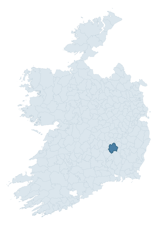
Where this barony sits in the Republic of Ireland
Geology and preservation
Bedrock geology shapes the landscape long before any settlement begins — controlling soil drainage, agricultural potential, the survival of upstanding monuments, and the preservation of buried archaeology. The figures below come from the Geological Survey Ireland 1:100,000 bedrock map.
The bedrock underlying Fassadinin is predominantly shale (43% of the barony by area), laid down during the Carboniferous period (100% by area, around 359 to 299 million years ago). Shale weathers to thin, acidic, frequently waterlogged soils, historically marginal for arable but suited to upland pasture and bog development. Shale-dominated baronies often carry sparse ringfort records and a higher representation of bog-preserved archaeology. A substantial secondary geology of siltstone (22%) and sandstone (14%) adds further variety to the underlying landscape. The single largest mapped unit is the Coolbaun Formation (38% of the barony's bedrock).
Rock type composition
Largest mapped unit: Coolbaun Formation (38% of the barony)
Placename evidence
Logainm records 34 heritage-diagnostic placenames for Fassadinin, drawn from townland and civil-parish names across the barony. The dominant stratum is pre-Christian and Early Medieval defensive — ráth-, lios-, dún-, and caiseal-prefixed names that mark Iron Age and early historic settlement. The leading diagnostic roots are cill- (11 — church), ráth- (9 — earthen ringfort), and dún- (5 — hilltop fort or promontory fort). This is broadly in line with the ROI average of 30.7 heritage placenames per barony. The presence of multiple heritage strata side by side indicates layered occupation of the landscape across successive prehistoric and historic periods. Logainm records 137 placenames for Fassadinin (predominantly townland names). Of these, 34 (25%) carry one of the diagnostic Gaelic roots tracked above; the remainder draw on more generic landscape vocabulary that does not encode a heritage period.
Pre-Christian / Early Medieval Defensive
| Root | Count | Meaning |
|---|---|---|
| ráth- | 9 | earthen ringfort |
| dún- | 5 | hilltop or promontory fort |
| lios- | 3 | ringfort or enclosure |
Early Christian Ecclesiastical
| Root | Count | Meaning |
|---|---|---|
| cill- | 11 | church (early) |
| domhnach- | 2 | pre-Patrician or earliest Patrician church |
| gráinseach- | 2 | monastic farm / grange |
| mainistir- | 1 | monastery |
| díseart- | 1 | hermitage |
Burial, Ritual, and Norse-Contact
| Root | Count | Meaning |
|---|---|---|
| gall- | 1 | foreigner — Norse settlement marker |
Other baronies in Kilkenny
About this profile
Click any section below to expand.
What is a barony?
A barony is a historic administrative unit in Ireland, broadly equivalent to an English hundred. The 280 baronies used here are from the OSi 2019 National Statutory Boundaries (generalised 20m), covering the 26 counties of the Republic of Ireland. Baronies derive from the Norman period, were formalised in the 17th century, and have not been redrawn for statistical purposes. They vary enormously in area, from compact urban baronies in Dublin to vast upland baronies in Connacht, and should not be compared by raw site count without accounting for area differences.
What counts as a site?
This profile combines three distinct heritage registers, each with its own definition of what constitutes a recordable site:
- Archaeological sites (NMS). The National Monuments Service Sites and Monuments Record (SMR) catalogues every known archaeological monument or site of archaeological interest in the Republic, from prehistoric burial mounds and ringforts to medieval churches and post-medieval defensive works. Inclusion does not require legal protection — only that the site has been identified, surveyed, and assessed as having archaeological value. A separate subset of these sites lies within a recorded protection zone, which gives them statutory protection under the National Monuments Acts.
- Listed buildings (NIAH). The National Inventory of Architectural Heritage records buildings of architectural, historical, archaeological, artistic, cultural, scientific, social, or technical interest. Each surveyed structure is appraised on a five-tier scale: International, National, Regional, Local, and Record-Only. The NIAH appraisal is informational rather than strictly statutory, but it underpins local-authority Record of Protected Structures (RPS) listings.
- Heritage placenames (Logainm). Logainm is the authoritative database of Irish placenames maintained by the Placenames Branch. This profile applies a heritage-diagnostic classifier to the Irish-language form of each townland name, flagging roots that signal defensive sites (ráth-, lios-, dún-, caiseal-, cathair-), ecclesiastical foundations (cill-, teampall-, domhnach-, mainistir-), prehistoric burial-ritual features (tuaim-, carn-, leaba-), or Norse-contact settlement (gall-). Townlands without one of these diagnostic roots are not flagged here — they may still carry historical significance, but that significance is not encoded in the name itself.
Editorial principles
The narrative sections of this profile follow several explicit principles:
- Evidential. Every claim about this barony’s heritage character is anchored in the underlying register data. Where a site count, a placename count, or a percentile rank is cited, it is computed from the source datasets at export time, not estimated.
- Comparative. Counts and metrics are reported alongside their percentile rank against the other 279 ROI baronies. A barony with 50 ringforts in absolute terms could be unusually high or unusually low depending on its size and regional context; percentile ranking removes that ambiguity.
- Transparent on limits. Where a register has known coverage gaps, survey biases, or data-quality issues that affect this barony’s figures, the profile flags them rather than presenting the numbers as definitive.
- No interpretation beyond what the data supports. The narrative does not speculate about historical events, social dynamics, or cultural meaning beyond what the recorded heritage and placename evidence directly attests.
Data caveats and limits
- NMS Sites and Monuments Record is the product of survey campaigns conducted at different intensities across different counties and decades. Some baronies have been surveyed more thoroughly than others, and absolute counts should be read in that light. Sites destroyed by development before survey are typically not represented; sites in heavily forested or upland terrain are sometimes under-recorded.
- NIAH coverage is broadly complete for the Republic of Ireland but the survey was conducted on a rolling county-by-county basis, and the most recent appraisal date varies. Buildings demolished or substantially altered after their original survey may still appear in the register; conversely, recent buildings of merit may not yet have been appraised.
- Logainm classification applies a deliberately conservative pattern-matching approach to the Irish-language townland forms. The classifier prioritises true positives over recall: a townland may carry a heritage signal that the classifier doesn’t recognise, particularly where the diagnostic root has been heavily anglicised or where the townland name draws on a less common term. The 60,000+ townland records and ~9,800 classified placenames give a substantial signal at barony scale, but individual townland names should be checked against Logainm directly for definitive interpretation.
- Period attribution. The chronological distribution reflects only those NMS sites that carry a recognised period attribution in the source data. Sites listed as “Unknown” period are excluded from the dated subset.
- Boundary changes. Some baronies have undergone minor boundary adjustments since their 19th-century definition; the OSi 2019 generalised boundaries used here are the current statutory definition and may differ slightly from historical maps in border areas.
- Bedrock geology is mapped at 1:100,000 scale, which means local variation within a barony — small pockets of different rock type, mineral veins, alluvium overlying bedrock — is generalised. The dominant-system and rocktype figures are area-weighted, so a barony reading “70% Carboniferous limestone” may still contain small but archaeologically important pockets of older or younger rock. Around 3% of GSI polygons do not match the lexicon and contribute no rocktype or system attribution.
Data sources
- National Monuments Service — Sites and Monuments Record (SMR) https://data.gov.ie/dataset/national-monuments-service-archaeological-survey-of-ireland
- National Inventory of Architectural Heritage (NIAH) https://data.gov.ie/dataset/national-inventory-of-architectural-heritage-niah-national-dataset
- Logainm — Placenames Database of Ireland https://www.logainm.ie/
- Ordnance Survey Ireland — National Statutory Barony Boundaries 2019 https://data-osi.opendata.arcgis.com/
- EURODEM — European Digital Elevation Model https://www.mapsforeurope.org/datasets/euro-dem
- ESA WorldCover https://esa-worldcover.org/en
- Geological Survey Ireland — 1:100,000 Bedrock Geology https://www.gsi.ie/en-ie/data-and-maps/Pages/Bedrock.aspx
Explore more: Search any of the 280 ROI baronies, browse by historical province, or read the methodology and data sources for the full Republic of Ireland Heritage Tool.