Moyashel And Magheradernon is a barony of County Westmeath, in the historical province of Leinster (Irish: Maigh Asail agus Machaire Ó dTiarnáin), covering 174 km² of land. The barony records 475 NMS archaeological sites and 284 NIAH listed buildings, placing it at around the 75th percentile among 280 ROI baronies for sites per km². This means it is in the top third of all baronies for sites per km². Dated archaeological evidence runs from the Neolithic through to the Modern, spanning 8 of 9 archaeological periods, placing the barony in the 55th percentile among 280 ROI baronies for chronological depth. This means it is in the upper half of all baronies for chronological depth. The largest dated subset of recorded sites dates to the Early Medieval.
Heritage at a glance
Percentile rankings throughout this profile compare each barony only against the other 279 Republic of Ireland baronies.
The recorded heritage of Moyashel And Magheradernon
The National Monuments Service Sites and Monuments Record (SMR) is the statutory inventory of archaeological sites for the Republic of Ireland, maintained by the Department of Tourism, Culture, Arts, Gaeltacht, Sport and Media. Sites recorded here include earthworks, ringforts, megalithic tombs, ecclesiastical remains, and post-medieval features; not every record is legally protected, but each is registered as a monument of archaeological interest.
The National Monuments Service records 475 archaeological sites in Moyashel And Magheradernon, putting it at the 75th percentile among 280 ROI baronies for sites per km². This means it is in the top third of all baronies for sites per km². Protection coverage is near-universal — 466 sites (98%) fall within a recorded monument protection zone, indicating an extensively surveyed landscape. The dominant category is defensive sites — ringforts, enclosures, hillforts, and stone forts (258 sites, 54% of the record). Ringfort – rath is the most prevalent type, making up 31% of the barony's recorded sites (146 records) — well above the ROI average of 20% across all baronies where this type occurs. Ringfort – rath is an earthen ringfort enclosed by a bank and external ditch — the most common Early Medieval farmstead, broadly dated 500–1000 AD. Other significant types include Ringfort – unclassified (27) and Hut site (22). Ringfort – unclassified is a circular Early Medieval settlement enclosure where surviving evidence does not allow distinction between earthen and stone forms; Hut site is a low stone or earthen foundation enclosing a small circular or oval area, generally interpreted as a former dwelling, of any date from prehistory to the medieval period. Across the barony's 174 km², this gives a recorded density of 2.73 sites per km².
Most common monument types
Hover or tap a monument type to see its definition.
| Type | Count |
|---|---|
| Ringfort – rath an earthen ringfort enclosed by a bank and external ditch — the most common Early Medieval farmstead, broadly dated 500–1000 AD | 146 |
| Ringfort – unclassified a circular Early Medieval settlement enclosure where surviving evidence does not allow distinction between earthen and stone forms | 27 |
| Hut site a low stone or earthen foundation enclosing a small circular or oval area, generally interpreted as a former dwelling, of any date from prehistory to the medieval period | 22 |
| House – indeterminate date a habitation building whose date cannot be determined from available evidence | 20 |
| Castle – unclassified a castle whose form cannot be precisely classified, dating somewhere between the late 12th and 16th centuries | 15 |
| Earthwork an unclassified earthen structure with no diagnostic features that allow a more specific classification | 14 |
| Crannog an artificial or partly artificial island built up on a lake or river bed, in use from the 6th to 17th centuries AD | 13 |
| Enclosure a banked or ditched feature of uncertain type, used as a catch-all where the original function cannot be determined from surface evidence | 12 |
Chronological distribution
The dated archaeological record for Moyashel And Magheradernon spans from the Neolithic through to the Modern, with activity attested across 8 of 9 archaeological periods. Every period from earliest to latest is represented in the record — an unbroken sequence of dated activity across the full chronological span. Activity concentrates most heavily in the Early Medieval (223 sites, 53% of dated material), with the Iron Age forming a secondary peak (78 sites, 19%). A further 54 recorded sites (11% of the overall NMS register for the barony) carry no period attribution — appearing as 'Unknown' in the bar chart below. This typically reflects either records that pre-date the standardised period vocabulary or sites awaiting specialist dating review, rather than a genuine absence of chronological evidence.
Sample of recorded monuments
Show 25 sample monuments (of 475 total)
A representative sample of 25 recorded monuments drawn from the barony’s 475 total NMS entries. Sites within a recorded monument protection zone and rarer site types are prioritised so the list shows a meaningful cross-section rather than only the most common type. Each entry shows the official Sites and Monuments Record reference number and the description published by the National Monuments Service.
Hilltop enclosure
Situated on a prominent hillock in undulating grass-land. Ringfort (WM013-018—) 130m to NE, bowl-barrow (WM013-016—-) 220m to W. A monument which is difficult to classify due it its unusual morphology. Present…
Situated on a prominent hillock in undulating grass-land. Ringfort (WM013-018—) 130m to NE, bowl-barrow (WM013-016—-) 220m to W. A monument which is difficult to classify due it its unusual morphology. Present remains consists of a sub-oval shaped area (approx. diam. 25m NW-SE; 16m NE-SW) enclosed by a low earth and stone bank standing on the summit of a hillock (approx. diam. 80m N-S; 60m E-W) the base of which is enclosed by two earthen banks and an intervening fosse. The intervening space between the inner enclosure and the outer banks are not concentric with the inner enclosure, and the gap between them is 5m at E, and 33m at N. There is an entrance gap (inner bank Wth 2.6m; external bank Wth 2.25m) in the outer enclosing banks at N. Traces of cultivation ridges are visible running ESE-WNW across the intervening space.
Compiled by: Frank Coyne and Caimin O'Brien
Date of upload: 3 April 2018
Ringfort – cashel
Situated on a small natural rise in gently undulating grassland, overlooked by higher ground on all sides. Ringfort (WM013-079—) 140m to S. A circular shaped area (approx. diam. 22m NE-SW) enclosed by two poorly…
Situated on a small natural rise in gently undulating grassland, overlooked by higher ground on all sides. Ringfort (WM013-079—) 140m to S. A circular shaped area (approx. diam. 22m NE-SW) enclosed by two poorly preserved earthen banks and a shallow intervening fosse. Stone facing is visible in the internal face of the inner bank, and the fosse and outer bank have been levelled from E-SW. There is a possible entrance gap (Wth 1.1m) at WSW. A field fence running NE-SW intersects the perimeter of the monument at E.
See attached profile of monument surveyed and drawn by the ASI.
Monument surveyed in 2015 and described by McGuinness (2015, 72) as following: ‘This monument is very similar to WM013-074—- in both form and dimensions, comprising a broad, steep-sided, flattish topped mound or platform of stony earth (Diam. (flat top) 22.1m N-S x 21.6m E-W) rising from a lower platform (Diam. 33.8m E-W) to create a stepped effect. As with WM013-074—-, upper surface of monument is gently domed. The key distinction between the two sites is that there are clear but heavily denuded traces of a cashel wall around edge of upper step, with boulder revetment on its inner face, which rises 0.27m over the interior where highest at ENE, and 1.38m over the lower step where the latter is best preserved at NW. Part of cashel wall has been almost completely removed from disturbed SE edge of upper step. Lower step is best preserved at W and NW, where it is 3.50m in width, but it ha…
Settlement cluster
Situated on the S face of a prominent rocky knoll. Chapel site (WM013-088—-) located 460m to S. Depicted on the 1838 ed. OS six inch map as a complex of fields and small rectilinear enclosures annotated as ‘Old…
Situated on the S face of a prominent rocky knoll. Chapel site (WM013-088—-) located 460m to S. Depicted on the 1838 ed. OS six inch map as a complex of fields and small rectilinear enclosures annotated as ‘Old Town’. The OS field name books (No. 49, 29) recorded that 'in the centre of the townland of Tevrin a good many houses now in ruins. It is therefore called the old town'.
An area of linear banks and foundations of rectangular shaped houses defined by grass-covered earth and stone banks covering an area approx. 3 hectares in size. These earthworks represent the remains of a clustered settlement annotated as 'Old Town' on the 1838 ed. OS 6-inch map. These earthworks are clearly visible on Digital Globe aerial photograph. The remains of a possible sunken way of medieval date can be seen running roughly E-W on the S edge of the earthwork complex.
Compiled by: Frank Coyne and Caimin O'Brien
Date of upload: 23 July 2018
Henge
Surveyed in 2012 and described by McGuinness (2012, 36-7) as following: ‘Enormous circular enclosure (overall ext. diam. 115m ENE-WSW) comprising a flat-topped central platform surrounded by a broad, deep ditch and a…
Surveyed in 2012 and described by McGuinness (2012, 36-7) as following: ‘Enormous circular enclosure (overall ext. diam. 115m ENE-WSW) comprising a flat-topped central platform surrounded by a broad, deep ditch and a large, flat-topped external bank, with a circular mound and embanked enclosure on the central platform. There are many minor undulations on surface of platform and, given the extensive growth of nettles when examined, it is possible that there are other, unnoticed features here. Except for parts of NE and NW, perimeter of site is covered in trees and bushes; where these are present, bank and ditch are very well preserved on account of the roots creating a rigid mesh which keeps the earth front eroding, and the canopy lessening the impact of precipitation. In places, central platform appears to rise above external ground level, suggesting that the low hilltop has been scarped. Its upper surface measures 89m N-S x 82m E-W; the corresponding measurements for base of platform are 97m N-S x 90.5m E-W. Where well preserved, platform has clearly defined edge with steep drop into ditch, although in some places, such as WSW side, edge of platform is indistinct and ditch silted up due to movement of cattle. On well-preserved NW side, platform rises up to 2.6m above base of ditch. Where best preserved, ditch is flat-bottomed, up to 5m in width, and, where deepest at NW side, maximum depth below and perpendicular to a line joining top of bank to upper surface of platform…
Promontory fort – inland
Situated on a slight promontory of low-lying land, on the SE shoreline of Lough Owel, overlooking Lady's Island 370m to W, slightly higher ground to E, SE and S. Depicted on the 1837 ed. OS 6-inch map as the arc of a…
Situated on a slight promontory of low-lying land, on the SE shoreline of Lough Owel, overlooking Lady's Island 370m to W, slightly higher ground to E, SE and S. Depicted on the 1837 ed. OS 6-inch map as the arc of a bank enclosing a roughly oval shaped promontory to WNW. Depicted on the OS Fair Plan map as the arc of an enclosure extending across the neck of a small peninsula in Lough Owel, annotated ‘fort’. Depicted on the revised 1913 ed. OS 25-inch map as a slightly modified, more linear bank enclosing a roughly oval-shaped promontory to WNW.
Monument described in 1970 as an oval-shaped area (approx. dims. 68m NE-SW; 48m NW-SE) enclosed from NE-E-S by a fosse and bank. The fosse is wide, shallow and flat-bottomed fosse with a very slight bank on the upper edge of the scarp. Elsewhere the earthwork is bounded by a scarp which has a slight bank on its upper edge from S-WSW. There is no trace of a formal entrance. There is a natural rise in the interior at the outer edge of the NW quadrant. There is a small, subrectangular steep sided relatively modern platform at the upper edge of the scarp at NE, that looks like a golf tee. Monument is visible today as a roughly oval-shaped earthwork on Digital Globe aerial photography.
Compiled by: Alison McQueen, Vera Rahilly and Caimin O’Brien
Date of upload: 18 February 2019
Religious house – Dominican friars
The Urban Survey of Westmeath (Bradley et. al. 1985, 119-20) recorded that the Dominican Priory was founded in 1237 by the Petit family (Fenning 1964, 106-07). The Dominicans held chapters here in 1278, 1292, 1308 and…
The Urban Survey of Westmeath (Bradley et. al. 1985, 119-20) recorded that the Dominican Priory was founded in 1237 by the Petit family (Fenning 1964, 106-07). The Dominicans held chapters here in 1278, 1292, 1308 and 1314 (Fenning 1964, 188) which would suggest that it was house of some importance. An indulgence of 1432 granted in aid of the repair of the church mentions that 'forty professed friars' used be maintained by the house but noted that the priory had 'suffered so much from long wars and other calamities that hardly eight in priest’s orders reside therein, and that the buildings of the church and house themselves are threatened with ruin' (Cal. papal letters 1909, 446). In 1540 the extent of the priory noted that the thatched roof of the church was ruinous although the stone walls and window (sic) were 'in sufficient repair' (White 1943, 290-1). It also noted a stone tower and other buildings 'lately inhabited by the friars' but now 'in decay and unoccupied' within the precinct, which was surrounded by a stone wall. The priory was granted to Sir Gerald Fitzgerald of Croyboy in 1548 (White 1943, 291) and to Thomas Gorie in 1564 (Morrin 1861, 491). In 1541, however, the site of the priory was set aside for a new gaol (WM019-089007-) (Fenning 1964, 112) and this was carried into effect in 1566 when the site was granted to Walter Hope, a Dublin merchant, on condition that he build a gaol of which he was to be constable (11 Rep Deputy Keeper Public Records Irela…
Water mill – vertical-wheeled
The site of a medieval watermill known as the 'Moate Mill' located in the S quadrant of the historic town of Mullingar (WM019-089—-). This mill was located on the banks of the River Brosna in close proximity to the…
The site of a medieval watermill known as the 'Moate Mill' located in the S quadrant of the historic town of Mullingar (WM019-089—-). This mill was located on the banks of the River Brosna in close proximity to the present site of Westmeath County Council Offices. The mill known in the 17th century as 'the moate mylle' (Orpen 1911, ii, 86) belonged to Thomas Petit and was located SE of the Anglo-Norman motte castle (WM019-089005-) and immediately S of the fording point (WM019-089014-) over the River Brosna. In 1612 Thomas Petyt [Petit] of Irishtown was granted 'the Moate Mill on the S side of Mollingar' (Cal. pat. rolls Ire., Jas I, 233). The 1641 Survey of Mullingar recorded the existence of ‘the tan house (WM019-089049-), lying and being from the frank garden (WM019-089027-) of the said town on the north, the river (Brosna) leading to the motte mill on the east’ (Andrews and Davies 1992, 15). In 1667 the confirmation of a land grant to Sir Arthur Forbes under the Acts of Settlement and Explanation described the monument as 'Mount Mill with a parcell of pasture belonging to it' (NLI p 1895).
In 1682 Sir Henry Piers recorded that ‘the name of the town if Englished, imports the short mill; indeed in my time, here hath been an over-shaft mill (WM019-089006-) of the least wheel that ever I saw, which with buckets and all was not eight foot (2.4m) in diameter, but now it is converted into a breast mill. There are also in this town on the same water [River Brosna],…
Religious house – Augustinian canons
The Urban Survey of Westmeath (Bradley et. al. 1985, 118) recorded that this Augustinian foundation ‘otherwise Known as Domus Dei [House of God], this priory was founded for Augustinian canons c.1227 by Ralph Petit,…
The Urban Survey of Westmeath (Bradley et. al. 1985, 118) recorded that this Augustinian foundation ‘otherwise Known as Domus Dei [House of God], this priory was founded for Augustinian canons c.1227 by Ralph Petit, bishop of Meath (Gwynn and Hadcock 1970, 189). In 1306 the Ecclesiastical Taxation of Ireland valued the 'Temporalities of God's house of Mullingar' at £8 18s. 8d.' (Cal. doc. Ire., 259). In 1444 an indulgence was granted to aid the repair of the church (Cal. papal letters 1912, 483). At the Dissolution the extent noted that the church, belfry, house and other buildings were necessary for the entertainment of the Lord Deputy and for the defence of the neighbourhood but it specified that the stone cloister could be thrown down (White 1943, 286). The extent also mentions small castle near the site and a garden outside the east gate of the house, which implies that it stood with in its own precinct wall. The priory was then functioning as a parish church (WM019-089016-) (McNeill 1922, 20). In 1560 the site of the 'late monastery' of Mullingar was granted to Sir Richard Tuite (Morrin 1861, 439); 'a small castle' mentioned in this grant is presumably the one referred to in the extent, and identifies this as the Augustinian house. In 1667 the confirmation of a land grant to Sir Arthur Forbes under the Acts of Settlement and Explanation described the monument as 'The Abby & Precincts of ye Cannons Regular' (NLI p 1895).
In 1682 Sir Henry Piers recorded that ‘Her…
Religious house – Franciscan friars
The Urban Survey of Westmeath (Bradley et. al. 1985, 121) recorded that ‘marked on the O.S. maps at the north-east end of the town (WM019-089—-) this may be the site to which the Franciscans were reintroduced in the…
The Urban Survey of Westmeath (Bradley et. al. 1985, 121) recorded that ‘marked on the O.S. maps at the north-east end of the town (WM019-089—-) this may be the site to which the Franciscans were reintroduced in the seventeenth century’. Depicted as 'Friary in Ruins' on the 1837 ed. OS 6-inch map where it is shown located beside a Tuck and Corn Mill standing on the bank of the River Brosna. In 1984 the foundation trenches of a council housing scheme at Friars Mill Road was inspected and no evidence of any archaeological material was visible (SMR File 21/05/1984). The site of the Friary was located on the S side of Friars Mill Road opposite Cusack Park.
Compiled by: Caimin O'Brien and R. Barrett
Date of upload: 03 June 2014
Historic town
The medieval monuments in the historic town of Mullingar consisted of an Anglo-Norman motte & bailey castle (WM019-089005-), a stone castle known as Mullingar Castle (WM019-089001-), All Saints’ Parish Church…
The medieval monuments in the historic town of Mullingar consisted of an Anglo-Norman motte & bailey castle (WM019-089005-), a stone castle known as Mullingar Castle (WM019-089001-), All Saints’ Parish Church (WM019-089016-) and graveyard (WM019-089017-), St. Mary’s Augustinian Priory (WM019-089009-), Holy Trinity Dominican Priory (WM019-089004-), a Frankhouse (WM019-089027-) belonging to the Knights Hospitaller, numerous urban castles, a town gaol (WM019-089007-), a sessions house (WM019-089039-), a bridge (WM019-089015-) [Morans Bridge] over the River Brosna, a watermill (WM019-089006-) known as the Mote Mill and a tucking mill called Francis’s Mill (WM019-089033-). The motte and bailey castle was constructed close to the fording point (WM019-089014-) over the River Brosna. In medieval times the town of Mullingar was often referred to as Admullingar which was a reference to the ford over the River Brosna. In 1667 the confirmation of a land grant to Sir Arthur Forbes under the Acts of Settlement and Explanation listed in the town of Mullingar (WM019-089—-) , a mount which was the remains of the Anglo-Norman earth & timber castle (WM019-089005-), 8 castles (WM019-089001-; WM019-089010-; WM019-089029-; WM019-089030-; WM019-089032- ; WM019-089040-048-), 3 mills (WM019-089006-; WM019-089033-; WM019-089038-), a Dominican abbey (WM019-089004-), an Augustinian abbey of Canons Regular (WM019-089009-) and a Session House (WM019-089039-) (NLI p. 1895).
The medieval streets…
Water mill – horizontal-wheeled
The chute of an early medieval horizontal mill from the townland of Clonickilvant was sketched in manuscript notes by Rev. W. Falkiner, Killucan, Co. Westmeath, which is in the possession of Mrs Ruth Bayly-Vandeleur,…
The chute of an early medieval horizontal mill from the townland of Clonickilvant was sketched in manuscript notes by Rev. W. Falkiner, Killucan, Co. Westmeath, which is in the possession of Mrs Ruth Bayly-Vandeleur, Wardenstown, Co. Westmeath (Lucas 1969, 20).
Compiled by: Caimin O'Brien
Date of upload: 22 July 2015
Pit-burial
Situated in gently undulating pasture. Not depicted on the 1837 ed. OS 6-inch map or the revised 1913 ed. OS 25-inch map. A pit-burial was discovered during ploughing in 1964 (Vandeleur 1965, 256-257). The plough lifted…
Situated in gently undulating pasture. Not depicted on the 1837 ed. OS 6-inch map or the revised 1913 ed. OS 25-inch map. A pit-burial was discovered during ploughing in 1964 (Vandeleur 1965, 256-257). The plough lifted a large stone which had concealed the feature. The burial consisted of cremated bone mixed with charcoal in an oval pit of probable prehistoric date. The NMI indicated that the remains were typical of a Neolithic or Early Bronze Age cremation burial (NMI Reg. No. 1964:47). According to Lucas (1967, 11), a second similar burial was found in close proximity in 1966. Little is known of this burial as it appears to have been heavily disturbed during the process of being discovered.
Compiled by Alison McQueen, Vera Rahilly and Caimin O’Brien.
Date of upload: 05 July 2019
Bastioned fort
Situated in dense woodland and vegetation, on Dysart Island, on the western shores of Lough Ennel. Along with Great Island, this small ‘island’ now forms a promontory which is connected to the mainland by a wet boggy…
Situated in dense woodland and vegetation, on Dysart Island, on the western shores of Lough Ennel. Along with Great Island, this small ‘island’ now forms a promontory which is connected to the mainland by a wet boggy land bridge, having previously been much further into the Lough, prior to 20th century drainage works in the vicinity, as depicted on the 1837 ed. OS 6-inch map. Collectively these two islands are now known as Dysart Island, as shown on the revised 1913 ed. OS 25-inch map.
In 1682 Sir Henry Piers of Tristernagh wrote that in 'this lake is an island belonging to the land of Disert, which was in some sort fortified by the Irish in the latter end of the late wars, and held as a garrison by them, and made one of the chief repositories of their wealth, yet notwithstanding it was taken on composition by the English, who held it, until by the treachery of one Ryling of Mullingar, whom the governor of it trusted with his cots, for exportation of goods; he delivered the cots unto some of the Irish captains, who by this means in a dark night landed their men, and set on the governor unawares, and surprised him and his garrison' (Vallancey 1786, 42-3).
Woods (1907, 2), refers to this as ‘Fort Island’ and describes it as the largest island in Lough Ennell, which was garrisoned and used as a magazine by the Irish in 1641. It was seized by the Parliamentary forces on two occasions until held by them until the restoration (ibid). Monument described in 1982 as no surface…
Ford
According to the Urban Survey of Westmeath (Bradley et. al. 1985, 113-14), 'Mullingar, the county town of Westmeath, is situated in low-lying ground on the River Brosna between Lough Owel and Lough Ennell. In many…
According to the Urban Survey of Westmeath (Bradley et. al. 1985, 113-14), 'Mullingar, the county town of Westmeath, is situated in low-lying ground on the River Brosna between Lough Owel and Lough Ennell. In many medieval documents the name is prefixed by Ad- or Ath-, indicating that the town stood on an important ford (WM019-089014-)'. The Irish Historic Towns Atlas of Mullingar places the fording point to the SE of the motte castle (WM019-089005-) in an area where the Bleach Yard road [Ballinderry Road] crosses the River Brosna. This fording point is shown on Richards map of Mullingar dating from 1691 (Andrews and Davies 1992, 2).
Compiled by: Caimin O'Brien
Date of upload: 27 June 2014
Bridge
The 1641 Survey of Mullingar recorded the existence of ‘one mill (WM019-089038-) commonly called Mullynnehouny, lying and being from the bridge on the north, Hamons land on the east, Priorstreet (Austin Friars St.) on…
The 1641 Survey of Mullingar recorded the existence of ‘one mill (WM019-089038-) commonly called Mullynnehouny, lying and being from the bridge on the north, Hamons land on the east, Priorstreet (Austin Friars St.) on the South, to the town of Mullingar (WM089-019—-) aforesaid on the west’ (Andrews and Davies 1992, 15). This reference places the bridge at the W end of Main Street [Pearse St.] where the River Brosna crosses the main Dublin-Athlone road running through the centre of Mullingar town. According to the Urban Survey of Westmeath (Bradley et. al. 1985, 116) ‘the importance of Mullingar (WM019-089—-) as a fording point (WM019-089014-) has already been noted and there can be little doubt that this was a factor in the development of the town. The date of the construction of the first bridge is unknown but in 1569 'the bridge of Mullingar', is referred to as being near the churchyard (WM019-089017-) (11 Rep Deputy Keeper Public Records Ireland, 219).
Compiled by: Caimin O'Brien
Date of upload: 1 July 2014
Wall monument
17th century graveslab inserted into internal E face of W wall of entrance porch of the 19th century All Saints Anglican church. Described in the Urban Survey of Westmeath (Bradley et. al. 1985, 117-18) as following;…
17th century graveslab inserted into internal E face of W wall of entrance porch of the 19th century All Saints Anglican church. Described in the Urban Survey of Westmeath (Bradley et. al. 1985, 117-18) as following; ‘Leigh slab (dims. H 1.82m Wth 1.03m) is within the church (WM019-089015-) but the others (WM019-089019-/020-/021-/022-/023-) are in the graveyard (WM019-089017-) west of the church. James Leigh. 1683. Large rectangular limestone slab set into the west wall of the porch. Achievement of arms in false relief showing two impaled coats of arms on a heater shaped shield. The dexter side has a lion rampant in the first and fourth quarter, three eagles in the second quarter and two bars and a baton in the third; the sinister side has two chevrons. The shield is surmounted by a helmet with a torse and the crest is a lion holding a floriated staff. The motto at the base is VERTVS DVCIT HONORI. Incised inscription: THIS TOMBESTONE WITH VAULT AND/ PEW WERE ERECTED BY THE WORSHIP/ FULL Sr JAMES LEIGH KNIGHT AND/ DAME MARY HIS WIFE FOR THE USE/ AND BURYING PLACE OF THEM AND/ THEIRE POSTERITY ANNO DOMINI/ 1683’.
Compiled by: Caimin O'Brien and R. Barrett
Revised by: Caimin O'Brien
Date of revised upload: 19 June 2015
Religious house – Knights Hospitallers
In 1578 'the Frankehouse' is referred to and it is probably to be identified with the house of the Knights Hospitalers mentioned in 1541 (Bradley et. al. 1985,116). The precise location of the religious house belonging…
In 1578 'the Frankehouse' is referred to and it is probably to be identified with the house of the Knights Hospitalers mentioned in 1541 (Bradley et. al. 1985,116). The precise location of the religious house belonging to the Knights Hospitallers within the historic town of Mullingar (WM019-089—-) has not been identified. The 1641 Survey of Mullingar recorded the existence of ‘the Frainkhouse, lying and being from the street (Main St.) of the said town on the north, the river (Brosna) on the east, Hopes land on the south, to the lane (Church Avenue)leading to the churchyard (WM019-089017-) on the west’ (Andrews and Davies 1992, 15). This reference places the Frankhouse immediately W of the River Brosna on the S side Main St (Pearse St.) beside church avenue leading down to the church (WM019-089016-) and graveyard (WM019-089017-) (Ibid., 3).
Compiled by: Caimin O'Brien
Date of upload: 01 July 2014
Town defences
The town defences of the historic town of Mullingar (WM019-089—-) appear to have been first constructed in the late 16th century. In 1583 Queen Elizabeth granted that the 'portreeve, justices, and constables for the…
The town defences of the historic town of Mullingar (WM019-089—-) appear to have been first constructed in the late 16th century. In 1583 Queen Elizabeth granted that the 'portreeve, justices, and constables for the time being, should yearly appoint a special and sufficient person to collect the "commodities growing due", by reason of the fairs, to the use of the said town: and "thereof to make a just account immediately after either of said fairs", to the intent that the money from time to time be put into a treasury, to be employed yearly about the enclosing and fortifying of the town and things thereunto' (Anon. 1835, 1257). The Queen's letters also stated that the tolls of the markets of Mullingar, formerly granted, should be applied 'about the benefitte and strengthening of the town' (Ibid.). In 1609 an Inquisition into the estate of the deceased Thomas Hopp, Constable of Mullingar mentioned the existence of ‘the west gate in Mollingare' (Anon 1826, 3 Jac 1). It is not clear if the defences around the town were built of stone or whether they consisted of earthen banks flanked by external ditches or a combintaion of stone and earthen defences around the town. The 1641-53 Survey of Mullingar has several references to the existence of a town wall at Mullingar. This survey records that the dwelling house of Richard Nelan , a burgess in the town of Mullingar was 'lying and being from the walls of the said town on the north' (Andrews and Davies 1992, 14). This ref…
Courthouse
The Sessions House in 1641 was located on the S side of the Main Street of Mullingar town (WM019-089—-). The 1641 Survey of Mullingar recorded that there were ‘two cellars and one garden plot, under the sessions…
The Sessions House in 1641 was located on the S side of the Main Street of Mullingar town (WM019-089—-). The 1641 Survey of Mullingar recorded that there were ‘two cellars and one garden plot, under the sessions house, wherein Charles Whyte now dwells, lying and being from the street (Main St.) on the north, the house wherein sometimes Donnogh O Shiel dwelt on the east, the vicar’s garden on the south, to the now dwelling house of Elizabeth Guires on the west’ (Andrews and Davies 1992, 15). In 1667 the confirmation of a land grant to Sir Arthur Forbes under the Acts of Settlement and Explanation described the monument as 'The Cellars under rooms of ye Session House with a garden' (NLI p 1895).
In the second half of the 17th century a new courthouse was built, probably at a different location, maybe in the area where the Court House is located today. In 1682 Sir Henry Piers recorded that in the historic town of Mullingar (WM019-089—-) there was an ‘old session house also, being very narrow and inconvenient in all respects, a new one is a framing, very large and spacious according to the modes of modern architecture’ (Vallancey 1786, 78). Piers goes on to state that in Mullingar there 'are held continually, all assizes and sessions, four fairs yearly, and all public meetings of the county' (bid.). The precise location of the medieval courthouse or of the late 17th century courthouse has not been identified. The Historic Towns Atlas of Mullingar places the Sessio…
Cross – High cross
In 1837 John O’Donovan wrote in the Ordnance Survey Letters that the parish of Dysart was named after St. Maol Tuile ‘whose memory was celebrated at his holy wells (WM025-109—-) in the glebe about 30 years ago on the…
In 1837 John O’Donovan wrote in the Ordnance Survey Letters that the parish of Dysart was named after St. Maol Tuile ‘whose memory was celebrated at his holy wells (WM025-109—-) in the glebe about 30 years ago on the 28th or 29th of May’ (OSL vol. 1, 152). The Martyrology of Donegal recorded the 29th of May as the feast day of Maoltuile whose ‘baculus [or pastoral staff] works miracles on perjurers before they go out of the church. His well, and his yellow bell and his baculus and his statue, are there still. This is the first Maoltuile’ (O’Donovan 1864, 445). The Martyrology of Donegal lists the 30th of July as the feast day of the second ‘Maoltuile, son of Nochar’ (ibid.).
An early Christian monastery (WM025-110003-) or hermitage (dísirt) was founded here in the late 8th or early 9th century by Maol Tuile who died before the year 830. He was reputedly the son of Nóchaire of the Ceinéal Laoghaire of Meath (Ó Riain 2011, 447). Maol Tuile of Díseart (Dysart) was associated with Maol Ruain of Tallaght.
A small decorated sandstone pyramidal-shaped cross-base (H 0.55m; top Wth 0.29m; base Wth 0.32m) with a rectangular mortice or socket (dims. 0.12m x 0.07m x D 0.06m) on top which stands 2.2m N of the NW angle of Dysart Church ruins (WM025-110002-) in W quadrant of graveyard (WM025-110004-). Three faces of the cross are decorated with poorly preserved carvings that are difficult to identify. The carvings are framed by incised panels. The fourth face of the cross-…
Fish-pond
A pond located to the W of Dysart House may have the fish-pond listed in a 1609 land grant to Sir Robert Nugent of Walshestown. In this year Sir Robert Nugent was granted the manor of Disert [Dysart] which included 'a…
A pond located to the W of Dysart House may have the fish-pond listed in a 1609 land grant to Sir Robert Nugent of Walshestown. In this year Sir Robert Nugent was granted the manor of Disert [Dysart] which included 'a castle (WM025-169—-); a hall, and a stone bawn (WM025-169001-), with a lough, a stable, two barns, a haggard, 40 messuages, 50 gardens, and a fish pond in Disert' (Cal. pat. rolls Ire., Jas I, 196).
Compiled and revised by: Caimin O'Brien
Date of revised upload: 10 November 2017
Mass-rock
Situated in undulating rocky grassland with site of chapel (WM013-088—-) 280m to E. Ringfort (WM013-087—-) 140m to W and second ringfort (WM013-086—-) 130m to N. Large boulder known locally as 'Finn Mac Cool's…
Situated in undulating rocky grassland with site of chapel (WM013-088—-) 280m to E. Ringfort (WM013-087—-) 140m to W and second ringfort (WM013-086—-) 130m to N. Large boulder known locally as 'Finn Mac Cool's Pebble', described in 1967 as a mass rock located near E edge of field. Present remains consist of a natural boulder possibly splintered by weathering (OPW Field Report 14/11/1967). According to the local landowner this rock was known locally as the 'Mass Rock'. Bush marked on digital globe aerial photograph appears to mark site of mass rock.
In 1934 the following folklore about this mass rock was collected from Turin National School; 'Finn Mac Cool was supposed to be, one day, marching from Killucan past Edmonton to Turin. Meeting a large rock, in his path, he stooped down, and taking it up on his fingers, as tho' it were a pebble, threw it before him. The supposed pebble did not fall again to the ground until it reached Turin church – 21/2 miles distant. There it dropped into a field and is there to this day. Known by the name of "Finn Mac Cool's Pebble". It has been said that on this same rock in Turin, Mass was said during the "bad times" after burning of old chapel [WM013-088—] which was situated near rock' (The Schools’ Collection, Volume 0737, Page 004; www.duchas.ie). A second story from the same school gave the following account; 'A Mass Rock, where the priest said Mass in the Penal times is still to be seen in Turin ranch. The people came to…
Road – hollow-way
Situated on rising ground 150m E of large hilltop enclosure or possible henge (WM018-134—-). The remains of a hollow way or sunken road (L 171m x Wth 20m) flanked on either side by a low earthen bank leading towards…
Situated on rising ground 150m E of large hilltop enclosure or possible henge (WM018-134—-). The remains of a hollow way or sunken road (L 171m x Wth 20m) flanked on either side by a low earthen bank leading towards the hilltop enclosure at Ballynaclin is clearly visible on Digital Globe aerial photography.
Compiled by: Caimin O'Brien
Date of upload: 12 February 2019
Barrow – ditch barrow
Situated on flat poorly drained land with ring-barrow (WM019-095—-) 45m to W. Low outline of circular shaped mound (diam. 10m; H 0.2m) enclosed by fosse (Wth 2m; D 0.1m) with no evidence of an external…
Situated on flat poorly drained land with ring-barrow (WM019-095—-) 45m to W. Low outline of circular shaped mound (diam. 10m; H 0.2m) enclosed by fosse (Wth 2m; D 0.1m) with no evidence of an external bank.
Compiled by: Caimin O'Brien
Date of upload: 25 April 2019
Ringfort – rath
Monument surveyed in 2015 and described by McGuinness (2015, 50) as following: ‘Circular monument comprising a broad, steep-sided, flattish-topped mound or platform of stony earth (Diam. (flat top) 22.2m N-S x 21.4m…
Monument surveyed in 2015 and described by McGuinness (2015, 50) as following: ‘Circular monument comprising a broad, steep-sided, flattish-topped mound or platform of stony earth (Diam. (flat top) 22.2m N-S x 21.4m E-W) rising from a lower platform (Diam. 38m N-S x 36m E-W) to give a stepped effect. Upper surface of monument appears flat and approximately level from a distance, despite the land on which it is sited falling away much more sharply to E than to W; nonetheless, when seen up close, centre of upper surface is in fact gently domed, as if there were a low mound surrounded by a shallow ‘ditch’, the latter feature being most noticeable at N and SW. A few small boulders are visible on upper surface, some appearing to form linear features and other patterns. Height of upper step over lower varies only slightly around the perimeter (N: 0.91m; E: 1.36m; S: 1.23m; W: 1.22m), as does that of the lower step over ground level (N: 0.33m; E: not available; S: 0.81m; W: 0.55m); lower step on E side appears to slope gently downwards towards edge of monument. Around parts of circumference, e.g. at NE, lower step appears like a ditch with outer bank, possibly to keep the step at a similar level despite the varying height of surrounding ground level. Width of lower step varies quite broadly (N: 3.8m; E: 4.8m; S: 3.4m; W: 2.4m), although E side, where it is widest, has been disturbed. Edge of upper step from NW-W-S appears to have been revetted with boulders; no revetment is visib…
Listed buildings
The National Inventory of Architectural Heritage (NIAH) is a state survey appraising buildings of architectural, historical, archaeological, artistic, cultural, scientific, social, or technical interest. Each surveyed structure receives a rating from International (the highest, for buildings of European importance) through National, Regional, Local, and Record-Only.
The NIAH records 284 listed buildings in Moyashel And Magheradernon, the 86th percentile across ROI baronies for listed-building density. Among these, 10 are graded National — buildings of interest to the whole of Ireland rather than only its region. The Republic holds 937 National-graded buildings in total, so this barony accounts for around 1% of the national total. Construction dates concentrate most heavily in the Victorian (1830-1900) period. The most-recorded building type is house (113 examples, 40% of the listed stock).
Terrain and environment
Mean elevation across the barony is 102m — the 60th percentile among 280 ROI baronies for elevation. This means it is in the upper half of all baronies for elevation. Elevation matters for heritage because higher-altitude baronies typically favour defensive monuments — ringforts and hilltop forts placed on prominent ground — while lowland baronies are more likely to carry the dense settlement and church networks of intensive agricultural landscapes. Mean slope is 2.5° — the 26th percentile among 280 ROI baronies for slope. This means it is in the bottom third of all baronies for slope. Slope is a key control on both land use and archaeological preservation: steep ground resists ploughing and tends to preserve earthworks intact, while gentle slopes favour intensive cultivation that damages or destroys surface archaeology over time. The Topographic Wetness Index averages 11.4, the 72nd percentile among 280 ROI baronies for wetness. This means it is in the top third of all baronies for wetness. Drainage matters for heritage because poorly-drained ground preserves organic archaeology (wooden trackways, leather, textiles, and on rare occasions human remains) far better than free-draining soil; well-drained ground favours arable use but destroys organic material rapidly. The land cover is dominated by improved grassland (74%) and woodland (16%).
Terrain measurements
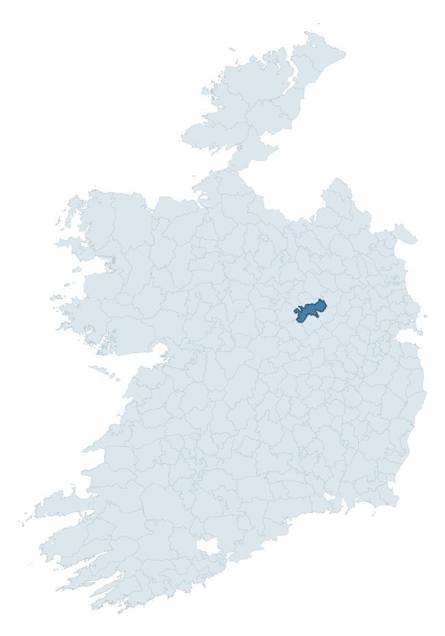
Where this barony sits in the Republic of Ireland
Geology and preservation
Bedrock geology shapes the landscape long before any settlement begins — controlling soil drainage, agricultural potential, the survival of upstanding monuments, and the preservation of buried archaeology. The figures below come from the Geological Survey Ireland 1:100,000 bedrock map.
The bedrock underlying Moyashel And Magheradernon is predominantly limestone (95% of the barony by area), laid down during the Carboniferous period (100% by area, around 359 to 299 million years ago). Limestone is the most heritage-rich bedrock in Ireland. It supports fertile, well-drained soils that favoured dense Early Medieval settlement and Norman manorial agriculture, and it weathers into karst features — sinkholes, caves, swallow holes, and souterrains — that frequently carry archaeology. Where peat overlies limestone, organic preservation can be exceptional. The single largest mapped unit is the Lucan Formation (76% of the barony's bedrock).
Rock type composition
Largest mapped unit: Lucan Formation (76% of the barony)
Placename evidence
Logainm records 12 heritage-diagnostic placenames for Moyashel And Magheradernon, a modest sample drawn predominantly from the townland record. The dominant stratum is early christian ecclesiastical. The most frequent diagnostic roots are cill- (5) and ráth- (2). With a sample of this size the count should be treated as indicative rather than definitive.
Pre-Christian / Early Medieval Defensive
| Root | Count | Meaning |
|---|---|---|
| ráth- | 2 | earthen ringfort |
Early Christian Ecclesiastical
| Root | Count | Meaning |
|---|---|---|
| cill- | 5 | church (early) |
| díseart- | 2 | hermitage |
| gráinseach- | 2 | monastic farm / grange |
Burial, Ritual, and Norse-Contact
| Root | Count | Meaning |
|---|---|---|
| carn- | 1 | cairn |
| gall- | 1 | foreigner — Norse settlement marker |
Other baronies in Westmeath
About this profile
Click any section below to expand.
What is a barony?
A barony is a historic administrative unit in Ireland, broadly equivalent to an English hundred. The 280 baronies used here are from the OSi 2019 National Statutory Boundaries (generalised 20m), covering the 26 counties of the Republic of Ireland. Baronies derive from the Norman period, were formalised in the 17th century, and have not been redrawn for statistical purposes. They vary enormously in area, from compact urban baronies in Dublin to vast upland baronies in Connacht, and should not be compared by raw site count without accounting for area differences.
What counts as a site?
This profile combines three distinct heritage registers, each with its own definition of what constitutes a recordable site:
- Archaeological sites (NMS). The National Monuments Service Sites and Monuments Record (SMR) catalogues every known archaeological monument or site of archaeological interest in the Republic, from prehistoric burial mounds and ringforts to medieval churches and post-medieval defensive works. Inclusion does not require legal protection — only that the site has been identified, surveyed, and assessed as having archaeological value. A separate subset of these sites lies within a recorded protection zone, which gives them statutory protection under the National Monuments Acts.
- Listed buildings (NIAH). The National Inventory of Architectural Heritage records buildings of architectural, historical, archaeological, artistic, cultural, scientific, social, or technical interest. Each surveyed structure is appraised on a five-tier scale: International, National, Regional, Local, and Record-Only. The NIAH appraisal is informational rather than strictly statutory, but it underpins local-authority Record of Protected Structures (RPS) listings.
- Heritage placenames (Logainm). Logainm is the authoritative database of Irish placenames maintained by the Placenames Branch. This profile applies a heritage-diagnostic classifier to the Irish-language form of each townland name, flagging roots that signal defensive sites (ráth-, lios-, dún-, caiseal-, cathair-), ecclesiastical foundations (cill-, teampall-, domhnach-, mainistir-), prehistoric burial-ritual features (tuaim-, carn-, leaba-), or Norse-contact settlement (gall-). Townlands without one of these diagnostic roots are not flagged here — they may still carry historical significance, but that significance is not encoded in the name itself.
Editorial principles
The narrative sections of this profile follow several explicit principles:
- Evidential. Every claim about this barony’s heritage character is anchored in the underlying register data. Where a site count, a placename count, or a percentile rank is cited, it is computed from the source datasets at export time, not estimated.
- Comparative. Counts and metrics are reported alongside their percentile rank against the other 279 ROI baronies. A barony with 50 ringforts in absolute terms could be unusually high or unusually low depending on its size and regional context; percentile ranking removes that ambiguity.
- Transparent on limits. Where a register has known coverage gaps, survey biases, or data-quality issues that affect this barony’s figures, the profile flags them rather than presenting the numbers as definitive.
- No interpretation beyond what the data supports. The narrative does not speculate about historical events, social dynamics, or cultural meaning beyond what the recorded heritage and placename evidence directly attests.
Data caveats and limits
- NMS Sites and Monuments Record is the product of survey campaigns conducted at different intensities across different counties and decades. Some baronies have been surveyed more thoroughly than others, and absolute counts should be read in that light. Sites destroyed by development before survey are typically not represented; sites in heavily forested or upland terrain are sometimes under-recorded.
- NIAH coverage is broadly complete for the Republic of Ireland but the survey was conducted on a rolling county-by-county basis, and the most recent appraisal date varies. Buildings demolished or substantially altered after their original survey may still appear in the register; conversely, recent buildings of merit may not yet have been appraised.
- Logainm classification applies a deliberately conservative pattern-matching approach to the Irish-language townland forms. The classifier prioritises true positives over recall: a townland may carry a heritage signal that the classifier doesn’t recognise, particularly where the diagnostic root has been heavily anglicised or where the townland name draws on a less common term. The 60,000+ townland records and ~9,800 classified placenames give a substantial signal at barony scale, but individual townland names should be checked against Logainm directly for definitive interpretation.
- Period attribution. The chronological distribution reflects only those NMS sites that carry a recognised period attribution in the source data. Sites listed as “Unknown” period are excluded from the dated subset.
- Boundary changes. Some baronies have undergone minor boundary adjustments since their 19th-century definition; the OSi 2019 generalised boundaries used here are the current statutory definition and may differ slightly from historical maps in border areas.
- Bedrock geology is mapped at 1:100,000 scale, which means local variation within a barony — small pockets of different rock type, mineral veins, alluvium overlying bedrock — is generalised. The dominant-system and rocktype figures are area-weighted, so a barony reading “70% Carboniferous limestone” may still contain small but archaeologically important pockets of older or younger rock. Around 3% of GSI polygons do not match the lexicon and contribute no rocktype or system attribution.
Data sources
- National Monuments Service — Sites and Monuments Record (SMR) https://data.gov.ie/dataset/national-monuments-service-archaeological-survey-of-ireland
- National Inventory of Architectural Heritage (NIAH) https://data.gov.ie/dataset/national-inventory-of-architectural-heritage-niah-national-dataset
- Logainm — Placenames Database of Ireland https://www.logainm.ie/
- Ordnance Survey Ireland — National Statutory Barony Boundaries 2019 https://data-osi.opendata.arcgis.com/
- EURODEM — European Digital Elevation Model https://www.mapsforeurope.org/datasets/euro-dem
- ESA WorldCover https://esa-worldcover.org/en
- Geological Survey Ireland — 1:100,000 Bedrock Geology https://www.gsi.ie/en-ie/data-and-maps/Pages/Bedrock.aspx
Explore more: Search any of the 280 ROI baronies, browse by historical province, or read the methodology and data sources for the full Republic of Ireland Heritage Tool.