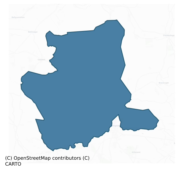
Philipstown Upper is a barony of County Offaly, in the historical province of Leinster (Irish: An Daingean Uachtarach), covering 150 km² of land. The barony records 172 NMS archaeological sites and 46 NIAH listed buildings, placing it at around the 18th percentile among 280 ROI baronies for sites per km². This means it is in the bottom fifth of all baronies for sites per km². Dated archaeological evidence runs from the Early Bronze Age through to the Modern, spanning 6 of 9 archaeological periods, placing the barony in the 14th percentile among 280 ROI baronies for chronological depth. This means it is in the bottom fifth of all baronies for chronological depth. The largest dated subset of recorded sites dates to the Iron Age.
Heritage at a glance
Percentile rankings throughout this profile compare each barony only against the other 279 Republic of Ireland baronies.
The recorded heritage of Philipstown Upper
The National Monuments Service Sites and Monuments Record (SMR) is the statutory inventory of archaeological sites for the Republic of Ireland, maintained by the Department of Tourism, Culture, Arts, Gaeltacht, Sport and Media. Sites recorded here include earthworks, ringforts, megalithic tombs, ecclesiastical remains, and post-medieval features; not every record is legally protected, but each is registered as a monument of archaeological interest.
The National Monuments Service records 172 archaeological sites in Philipstown Upper, putting it at the 18th percentile among 280 ROI baronies for sites per km². This means it is in the bottom fifth of all baronies for sites per km². Of these, 85 (49%) fall within a recorded monument protection zone — a modest share, suggesting many records await formal designation. The record is dominated by industrial sites — mills, kilns, and quarries (51 sites, 30% of the total), with defensive sites forming a substantial secondary presence (44 sites, 26%). Structure – peatland is the most prevalent type, making up 30% of the barony's recorded sites (51 records) — well above the ROI average of 15% across all baronies where this type occurs. Structure – peatland is a construction of unknown function, either extant or implied by archaeological evidence, of any date. Other significant types include Enclosure (26) and Road – class 3 togher (17). Enclosure is a banked or ditched feature of uncertain type, used as a catch-all where the original function cannot be determined from surface evidence; Road – class 3 togher is a short wooden peatland trackway up to 15m long, deliberately laid to cross a small area of bog; Neolithic to medieval. Across the barony's 150 km², this gives a recorded density of 1.14 sites per km².
Most common monument types
Hover or tap a monument type to see its definition.
| Type | Count |
|---|---|
| Structure – peatland a construction of unknown function, either extant or implied by archaeological evidence, of any date | 51 |
| Enclosure a banked or ditched feature of uncertain type, used as a catch-all where the original function cannot be determined from surface evidence | 26 |
| Road – class 3 togher a short wooden peatland trackway up to 15m long, deliberately laid to cross a small area of bog; Neolithic to medieval | 17 |
| Graveyard a burial area associated with a church, in use from the medieval period onwards | 7 |
| Church a building used for public Christian worship, of any date from c. 500 AD onwards | 7 |
| Castle – tower house a fortified residential tower of four or five storeys, mostly built by lords in the 15th and 16th centuries and often within a defended bawn | 3 |
Chronological distribution
The dated archaeological record for Philipstown Upper spans from the Early Bronze Age through to the Modern, with activity attested across 6 of 9 archaeological periods. This is the 14th percentile across ROI baronies — a relatively narrow chronological band, with much of Irish prehistory not represented in the dated record. The record is near-continuous, with only the Middle Late Bronze Age period falling inside the span without any recorded sites. Activity concentrates most heavily in the Iron Age (26 sites, 49% of dated material), with the Early Medieval forming a secondary peak (11 sites, 21%). A further 119 recorded sites (69% of the overall NMS register for the barony) carry no period attribution — appearing as 'Unknown' in the bar chart below. This typically reflects either records that pre-date the standardised period vocabulary or sites awaiting specialist dating review, rather than a genuine absence of chronological evidence.
Sample of recorded monuments
Show 25 sample monuments (of 172 total)
A representative sample of 25 recorded monuments drawn from the barony’s 172 total NMS entries. Sites within a recorded monument protection zone and rarer site types are prioritised so the list shows a meaningful cross-section rather than only the most common type. Each entry shows the official Sites and Monuments Record reference number and the description published by the National Monuments Service.
Barrow – ring-barrow
Known locally as 'O'Dempsey's Ring' this is a ring-barrow with low circular mound (diam. 7m) enclosed by inner fosse (Wth 2.5m) with external bank (Wth 2m) with evidence of stone kerbing in the construction of the bank.…
Known locally as 'O'Dempsey's Ring' this is a ring-barrow with low circular mound (diam. 7m) enclosed by inner fosse (Wth 2.5m) with external bank (Wth 2m) with evidence of stone kerbing in the construction of the bank. The overall diameter of the site measures 18m N-S.
The above description is derived from the published 'Archaeological Inventory of County Offaly' (Dublin: Stationery Office, 1997). In certain instances the entries have been revised and updated in the light of recent research.
Date of upload: 23 May 2011
This monument is subject to a preservation order made under the National Monuments Acts 1930 to 2014 (PO no. 1/1957).
Moated site
Large almost square shaped enclosure (int dims c. 66m N-S, c. 64m E-W) delimited by a U-shaped fosse (W 3.80m-6.50m) and external bank (ext. H 0.50m). Peat at NE angle. Possible entrance feature in centre of S…
Large almost square shaped enclosure (int dims c. 66m N-S, c. 64m E-W) delimited by a U-shaped fosse (W 3.80m-6.50m) and external bank (ext. H 0.50m). Peat at NE angle. Possible entrance feature in centre of S side.According to OS letters (O'Flanagan 1927, Vol 1, 1) there was possibly a wooden house inside the enclosure belonging to the chiefs of Clanmaliere.
Located on flat poorly drained land with bog immediately to the N and good flat pasture land on all other sides. To the W of this site there is a destroyed tower house (OF026-018—-) of which there are no surface traces visible and a medieval church (OF026-017001-) which still survives nearby. A very good example of a moated site with distinctive rounded corners and flat U shaped fosse with evidence that it previously contained water. The site consists of a raised square shaped platform (59.4m N-S; 66m E-W; ext. H 2.1m) which is enclosed by a poorly preserved earthen bank , wide flat bottomed fosse (Wth 6m) with external bank (Wth 3m; ext. H 0.5m; int. H 1m). Possible leat at the NE angle. The site is locally known as the 'Sconce' meaning a raised area. Possible evidence for an entrance feature survives on the S side of the site where the external bank shows signs of disturbance. On the 1654 map of Offaly a large house is depicted inside the moat in the centre of the platform, possible remains of this house show up on the Cambridge aerial photographs along with possible destroyed entrance feature. According to O'…
House – medieval
Located on flat poorly drained land with bog immediately to the N and good flat pasture land on all other sides. To the W of this site there is a destroyed tower house (OF026-018—-) of which there are no surface…
Located on flat poorly drained land with bog immediately to the N and good flat pasture land on all other sides. To the W of this site there is a destroyed tower house (OF026-018—-) of which there are no surface traces visible and a medieval church (OF026-017001-) which still survives nearby. A very good example of a moated site (OF026-019001-) with distinctive rounded corners and flat U shaped fosse with evidence that it previously contained water. The site consists of a raised square shaped platform which is enclosed by a poorly preserved earthen bank , wide flat bottomed fosse with external bank. Possible leat at the NE angle. The site is locally known as the 'Sconce' meaning a raised area. Possible evidence for an entrance feature survives on the S side of the site where the external bank shows signs of disturbance. On the 1654 map of Offaly a large house is depicted inside the moat in the centre of the platform, possible remains of this house show up on the Cambridge aerial photographs along with possible destroyed entrance feature. According to O' Flanagan (1933, vol. 1, 1) this entrenchment was thrown up to protect a wooden house known locally as 'The Frame House'.
Compiled by: Caimin O'Brien.
Date of upload: 23 May 2011
Well
Well marked on 1st. ed. OS 6-inch map at E side of stream, 1913 ed. has it marked on W side. Stream now dredged and well no longer visible. (ITA Survey 1942).
Not visible at ground level.
The above description is…
Well marked on 1st. ed. OS 6-inch map at E side of stream, 1913 ed. has it marked on W side. Stream now dredged and well no longer visible. (ITA Survey 1942).
Not visible at ground level.
The above description is derived from the published 'Archaeological Inventory of County Offaly' (Dublin: Stationery Office, 1997). In certain instances the entries have been revised and updated in the light of recent research.
Date of upload: 23 May 2011
Mill – unclassified
This is possibly the site of a medieval mill mentioned in the Down Survey. No surface remains visible of any mill of medieval date. The corn mill depicted on the OS 6-inch map dates from the 18th century.
The above…
This is possibly the site of a medieval mill mentioned in the Down Survey. No surface remains visible of any mill of medieval date. The corn mill depicted on the OS 6-inch map dates from the 18th century.
The above description is derived from the published 'Archaeological Inventory of County Offaly' (Dublin: Stationery Office, 1997). In certain instances the entries have been revised and updated in the light of recent research.
Date of upload: 23 May 2011
Castle – motte and bailey
Well preserved motte and bailey located on top of an esker ridge with good views in all directions, with early medieval church (OF026-022—–) nearby and small stream to the W. Flat topped steep sided conical shaped…
Well preserved motte and bailey located on top of an esker ridge with good views in all directions, with early medieval church (OF026-022—–) nearby and small stream to the W. Flat topped steep sided conical shaped mound (H 7.5m; top diam 11.5m; base diam 46m) with enclosing fosse (Wth 4.6-8m; D 1m) at its base and raised rectangular shaped bailey (47m E-W; 39m N-S; H 1.5m) to the N which is enclosed by an earthen bank at N, E and W.
The above description is derived from the published 'Archaeological Inventory of County Offaly' (Dublin: Stationery Office, 1997). In certain instances the entries have been revised and updated in the light of recent research.
Date of upload: 23 May 2011
Ritual site – holy well
Two holy wells located side by side in a field adjacent to the E of Sranure graveyard (OF026-033001-). Both of these water filled wells are enclosed by modern concrete stiles with coins visible at the bottom. According…
Two holy wells located side by side in a field adjacent to the E of Sranure graveyard (OF026-033001-). Both of these water filled wells are enclosed by modern concrete stiles with coins visible at the bottom. According to the OS 'The well and field near to the parish church were called by this name, and a pattern was formerly held here on St John's Day' (OSFNB 1837-40, vol. 1, 64). Test excavation that was undertaken by Dominic Delany under licence no. 01E0431 on the site of a proposed new dwelling at Sranure, Co. Offaly, on 28 May 2001 revealed remains of possible ecclesiastical enclosure (OF026-033002-). The development site lies immediately east of a church site (OF026-033—-) and graveyard (OF026-033001-) and there is a holy well (OF026-034—-) in the field to the north.
The above description is derived from the published 'Archaeological Inventory of County Offaly' (Dublin: Stationery Office, 1997). In certain instances the entries have been revised and updated in the light of recent research.
Date of upload: 23 May 2011
Mound
Marked on 2nd ed. OS 6-inch map as a mound surrounded by a fosse. Levelled, no visible surface traces.
The above description is derived from the published 'Archaeological Inventory of County Offaly' (Dublin:…
Marked on 2nd ed. OS 6-inch map as a mound surrounded by a fosse. Levelled, no visible surface traces.
The above description is derived from the published 'Archaeological Inventory of County Offaly' (Dublin: Stationery Office, 1997). In certain instances the entries have been revised and updated in the light of recent research.
Date of upload: 23 May 2011
Crannog
A sub-circular palisaded enclosure (dims. 19.8m NNE-SSW x 14m min. WNW-ESE; D 0.1m min.) enclosing an area of c. 300m2. The site consists of an outer palisade of posts (diam. 0.08-0.12m) constructed principally of…
A sub-circular palisaded enclosure (dims. 19.8m NNE-SSW x 14m min. WNW-ESE; D 0.1m min.) enclosing an area of c. 300m2. The site consists of an outer palisade of posts (diam. 0.08-0.12m) constructed principally of single posts. Internal to the palisade by c. 1m is a second line of posts (av. diam. 0.09-0.1m) but it is unclear whether they continue in a full circle. At the centre of the enclosure a large oval-shaped hearth of ash, charcoal and occasional small burnt stones is partially exposed. At two corners of the hearth are c. sixty very closely set vertical posts (diam. 0.05-0.12m) possibly representing a substructure. Horizontal roundwoods form a rectilinear surface around the hearth on three sides. Leading away from this surface to the W is a narrow band of timbers, roundwoods, brushwood and bark fragments suggesting a path or entrance way. The hearth, wooden surface and the possible entrance way are enclosed by stakes forming two arcs which may join to create a circular wall around the central hearth. Seven disturbed artefacts were recovered from the field surface. The site lies in poorly humified Sphagnum peat with occasional Eriophorum and a large amount of fibrous roots and natural wood including some large root boles. Radiocarbon dated to cal. AD 538-659 (Wk-13754). SMR OF026-054—- is 2.31m from the E edge of this site and it seems likely that the two are associated.
The site is located in Ballykean Bog, 5km south-east of Daingean, and was discovered by the…
Ecclesiastical enclosure
Test excavation was undertaken by Dominic Delany under licence no. 01E0431 on the site of a proposed new dwelling at Sranure, Co. Offaly, on 28 May 2001. The development site lies immediately east of a church site…
Test excavation was undertaken by Dominic Delany under licence no. 01E0431 on the site of a proposed new dwelling at Sranure, Co. Offaly, on 28 May 2001. The development site lies immediately east of a church site (OF026-033—-) and graveyard (OF026-033001-) and there is a holy well (OF026-034—-) in the field to the north. The church is named 'Temple Kieran' on OS 6-inch maps and its site is indicated east of centre in the large rectangular graveyard. A grass-covered rubble mound now marks the church site.
Testing comprised the mechanical excavation of four trenches, extending east-west across the development site. No features were encountered in Trenches 1, 2 and 4, but two possible archaeological features were discovered in Trench 3. Feature 1 was a linear/curvilinear round-bottomed ditch, 2.55m wide and 0.9m deep, oriented north-east/south-west. The ditch fills were similar to the topsoil although not as compacted and slightly darker in colour. The upper fill was 0.8m thick and at its base there was a loose stone fill containing frequent lumps of iron slag, some of which were quite large and bowl-shaped. This fill also yielded some animal bone (cattle, pig jaw) and an iron nail. The lower fill was slightly darker as it was mixed with the orange silty sand subsoil. No finds were recovered from this fill. Feature 2 was a linear cut, 1.25m wide and 0.25m deep, also orientated north-east/south-west but not running parallel to the ditch feature. The upper fill was compac…
Ring-ditch
Cropmark of circular-shaped area (approx. diam. 10m) visible on Google earth aerial imagery.
See attached image taken from Google Earth aerial photographs taken 02/07/2018
Compiled by: Caimin O'Brien based on…
Cropmark of circular-shaped area (approx. diam. 10m) visible on Google earth aerial imagery.
See attached image taken from Google Earth aerial photographs taken 02/07/2018
Compiled by: Caimin O'Brien based on details provided by Jean-Charles Caillère
Date of upload: 09 September 2019
Platform – peatland
This site is located in the industrial peatlands of Clonad Bog. It was recorded in a drain face c. 0.14m below the field surface during the 2013 Reassessment Peatland Survey (Whitaker 2014).
On excavation in 2014…
This site is located in the industrial peatlands of Clonad Bog. It was recorded in a drain face c. 0.14m below the field surface during the 2013 Reassessment Peatland Survey (Whitaker 2014).
On excavation in 2014 (licence 14E0354) the site was exposed to be a possible platform. A single cutting, measuring 5x2m, was opened; the E extent of the cutting was truncated by a drain. The overlying peat was well-humified Sphagnum peat. The possible platform was composed of closely placed NW-SE orientated brushwood and roundwood elements, measuring a maximum of 1.4m in length. They were laid a maximum of two layers deep. The underlying peat was moderately humified.
A fragment of alder was chosen for AMS dating and returned a result of cal. 1923-1752 BC (UBA 26630).
Compiled by: Jane Whitaker/Femke Vleeshouwer
Date of upload: 25 February 2020
Burnt spread
In tillage field, 300m E of Lough Banagher. Feature identified by Séamus Ó Murchú in the course of an archaeological desk based assessment of a forestry felling licence application. Visible as a dark soil mark (dims.…
In tillage field, 300m E of Lough Banagher. Feature identified by Séamus Ó Murchú in the course of an archaeological desk based assessment of a forestry felling licence application. Visible as a dark soil mark (dims. c. 38m E-W x 24m N-S) on aerial imagery available on the Department of Agriculture, Food and the Marine iFORIS system. Elongated dark spread visible on Digital Globe orthoimages taken 2011-13.
Compiled by: Caimin O'Brien based on details provided by Séamus Ó Murchú
Date of upload: 27 August 2021
Burial ground
Not visible at ground level. Marked on all editions of OS 6-inch maps.
The above description is derived from the published 'Archaeological Inventory of County Offaly' (Dublin: Stationery Office, 1997). In certain…
Not visible at ground level. Marked on all editions of OS 6-inch maps.
The above description is derived from the published 'Archaeological Inventory of County Offaly' (Dublin: Stationery Office, 1997). In certain instances the entries have been revised and updated in the light of recent research.
Date of upload: 23 May 2011
Children's burial ground
Subrectangular shaped area (35m N-S) defined by slight remains of an earthen bank and rough stone wall, situated on a slight rise. No obvious grave markers, site overgrown at time of visit. Modern water tower in NE…
Subrectangular shaped area (35m N-S) defined by slight remains of an earthen bank and rough stone wall, situated on a slight rise. No obvious grave markers, site overgrown at time of visit. Modern water tower in NE angle. The following folklore was recorded from Walsh Island school in 1938; 'There is a field there called "The Relic" meaning graveyard. It was formerly a burial place for unbaptised children. Adjoining this graveyard is a long stone wall called the Range wall. It is built of peculiar field stones which are perfectly round. At one end of this wall there was an old schoolhouse long ago. A schoolmaster by the name of Kennefick taught there' (The Schools’ Collection, Volume 0803, Page 065)
The above description is derived from the published 'Archaeological Inventory of County Offaly' (Dublin: Stationery Office, 1997). In certain instances the entries have been revised and updated in the light of recent research.
Compiled and revised by: Caimin O'Brien
Date of revised upload: 25 April 2019
Ringfort – unclassified
Eastern portion of enclosure shows on aerial photo (N 506/5) but western portion is visible on the ground. Univallate ringfort (max N-S chord c. 43m) defined by shallow fosse and much degraded internal bnak. Interior…
Eastern portion of enclosure shows on aerial photo (N 506/5) but western portion is visible on the ground. Univallate ringfort (max N-S chord c. 43m) defined by shallow fosse and much degraded internal bnak. Interior slightly raised above the level of the surrounding field.
Located on flat well drained terrain in undulating countryside. Only the W half survives although the outline of the E half is still discernible under suitable conditions. A field fence dissects the site on a N-S axis. What remains of the site is in fair condition and consists of a raised platform (diam 45m N-S; ext. H 1m) enclosed by two poorly preserved earthen banks with intervening fosse (Wth 2m). No entrance feature visible. Aerial photographs (GSI N, 506/5; 175/4) shows outline of circular ringfort.
The above description is derived from the published 'Archaeological Inventory of County Offaly' (Dublin: Stationery Office, 1997). In certain instances the entries have been revised and updated in the light of recent research.
Date of upload: 23 May 2011
Graveslab
Only the S and W walls of a poorly preserved church (OF026-017001-) survives built with uncoursed rubble with punch dressed quoins. Raised rectangular graveyard (OF026-017002-) with 18th and 19th-century headstones.…
Only the S and W walls of a poorly preserved church (OF026-017001-) survives built with uncoursed rubble with punch dressed quoins. Raised rectangular graveyard (OF026-017002-) with 18th and 19th-century headstones. 17th-century O'Dempsey graveslab dating to 1699 located near S wall of graveyard unlocated due to dense overgrowth (OHAS file 1974) .
The above description is derived from the published 'Archaeological Inventory of County Offaly' (Dublin: Stationery Office, 1997). In certain instances the entries have been revised and updated in the light of recent research.
Date of upload: 23 May 2011
Castle – unclassified
Raheen Castle depicted as a small square-shaped building on the 1838 ed. OS 6-inch map standing immediately S of a laneway/roadway a few metres NNW of a farmyard. Location of castle site incorrectly depicted on revised…
Raheen Castle depicted as a small square-shaped building on the 1838 ed. OS 6-inch map standing immediately S of a laneway/roadway a few metres NNW of a farmyard. Location of castle site incorrectly depicted on revised editions of the OS 6-inch and 25-inch maps where the castle is shown located further to the W than on the 1838 ed. OS 6-inch map. Castle was situated on high ground overlooking Raheen Lough to the SW. Now levelled with just a few large stones showing through the surface which may be the remains of the foundations.
The above description is derived from the published 'Archaeological Inventory of County Offaly' (Dublin: Stationery Office, 1997). In certain instances the entries have been revised and updated in the light of recent research.
Compiled by: David Sweetman
Revised by: Caimin O'Brien
Date of revised upload: 23 June 2016
Bawn
Possible bawn within townland described in the OS Field Name Books 1837-40 as a 'Turret consisting of a stump of a circular tower, remains of some walls' (OSFNB 1837-40, p. 60). May have been describing the remains of a…
Possible bawn within townland described in the OS Field Name Books 1837-40 as a 'Turret consisting of a stump of a circular tower, remains of some walls' (OSFNB 1837-40, p. 60). May have been describing the remains of a bawn wall and surviving cylindrical angle tower of O'Dempsey's castle (OF026-044—-).
The above description is derived from the published 'Archaeological Inventory of County Offaly' (Dublin: Stationery Office, 1997). In certain instances the entries have been revised and updated in the light of recent research.
Date of upload: 23 May 2011
Graveslab
Church (OF027-001001-) located in N section of irregular-shaped graveyard (OF027-001002-) which is enclosed by a stone wall. Graveslab dated 1603 not located but recorded and described in the late 19th century…
Church (OF027-001001-) located in N section of irregular-shaped graveyard (OF027-001002-) which is enclosed by a stone wall. Graveslab dated 1603 not located but recorded and described in the late 19th century (FitzGerald 1900,92; Williams 1898, 68). In 1898 Rev. Sterling de Courcy Williams recorded the inscription which read; 'OBITVS EVLINE FILIA DERMICII QVE OBIT 6 MARC 1603 / EBO LIAEVS FILIVS MAVRI EIVS MARITVS OVI ME FIERE'. He identified this graveslab as marking the resting place of Evelyn O'Dempsey who was a daughter of Dermot and wife to Lisagh or Lewis O'Dempsey of Clanmaliere. The graveslab measured 7 feet (2.13m) long and about 2 feet (0.6m) wide. (Williams 1898, 68).
The above description is derived from the published 'Archaeological Inventory of County Offaly' (Dublin: Stationery Office, 1997). In certain instances the entries have been revised and updated in the light of recent research.
Compiled and revised by: Caimin O'Brien
Date of revised upload: 29 November 2016
Ringfort – unclassified
Situated on a slight rise of ground. Completely levelled with only the bare outline of the site discernible.
The above description is derived from the published 'Archaeological Inventory of County Offaly' (Dublin:…
Situated on a slight rise of ground. Completely levelled with only the bare outline of the site discernible.
The above description is derived from the published 'Archaeological Inventory of County Offaly' (Dublin: Stationery Office, 1997). In certain instances the entries have been revised and updated in the light of recent research.
Date of upload: 23 May 2011
Castle – unclassified
Situated on a slightly elevated position close to house and farm buildings. Not visible at ground level.
The above description is derived from the published 'Archaeological Inventory of County Offaly' (Dublin:…
Situated on a slightly elevated position close to house and farm buildings. Not visible at ground level.
The above description is derived from the published 'Archaeological Inventory of County Offaly' (Dublin: Stationery Office, 1997). In certain instances the entries have been revised and updated in the light of recent research.
Date of upload: 23 May 2011
Children's burial ground
Possibly the remains of a ringfort (int. diam. N-S c. 41m) very overgrown with scrub and cut by roadway at W. Site defined by a slight bank (Wth c. 2m, int. H c. 1m) and external fosse (max. Wth 3m, D 1m). Davies…
Possibly the remains of a ringfort (int. diam. N-S c. 41m) very overgrown with scrub and cut by roadway at W. Site defined by a slight bank (Wth c. 2m, int. H c. 1m) and external fosse (max. Wth 3m, D 1m). Davies (ITASurvey 1942) states that there was evidence of one or two graves in the enclosure but this could not be verified due to dense overgrowth.
The above description is derived from the published 'Archaeological Inventory of County Offaly' (Dublin: Stationery Office, 1997). In certain instances the entries have been revised and updated in the light of recent research.
Date of upload: 23 May 2011
Designed landscape – tree-ring
Shown on 6-inch maps as a tree-covered circular area – probably a landscape feature. Not visible at ground level. Probably a levelled tree-ring which shows up as a circular cropmark on the aerial photographs (Air Corps…
Shown on 6-inch maps as a tree-covered circular area – probably a landscape feature. Not visible at ground level. Probably a levelled tree-ring which shows up as a circular cropmark on the aerial photographs (Air Corps 672/1; 654/5).
The above description is derived from the published 'Archaeological Inventory of County Offaly' (Dublin: Stationery Office, 1997). In certain instances the entries have been revised and updated in the light of recent research.
Date of upload: 23 May 2011
Structure – peatland
A radially split plank (L 0.27m min.; Wth 0.21m; D 0.05m) in the drain face. It lies in well-humified Sphagnum peat with fibrous roots. The plank was dendrochronologically dated to AD 1205±9 (Q10136). Recorded by the…
A radially split plank (L 0.27m min.; Wth 0.21m; D 0.05m) in the drain face. It lies in well-humified Sphagnum peat with fibrous roots. The plank was dendrochronologically dated to AD 1205±9 (Q10136). Recorded by the Irish Archaeological Wetland Unit (University College, Dublin) in 2001. The evidence is not sufficient to warrant its acceptance as the remains of an archaeological monument.
The original survey description was compiled by the Irish Archaeological Wetland Unit (University College, Dublin). Assessed and revised by: Caimin O'Brien, Paul Walsh
Date of upload: 23 May 2011
Listed buildings
The National Inventory of Architectural Heritage (NIAH) is a state survey appraising buildings of architectural, historical, archaeological, artistic, cultural, scientific, social, or technical interest. Each surveyed structure receives a rating from International (the highest, for buildings of European importance) through National, Regional, Local, and Record-Only.
The NIAH records 46 listed buildings in Philipstown Upper (22nd percentile across ROI baronies). The highest-graded structure include 1 of National significance. The Republic holds 937 National-graded buildings in total, so this barony accounts for around 0% of the national total. Construction dates concentrate most heavily in the Victorian (1830-1900) period. The most-recorded building type is house (17 examples, 37% of the listed stock).
Terrain and environment
Mean elevation across the barony is 76m — the 37th percentile among 280 ROI baronies for elevation. This means it is in the lower half of all baronies for elevation. Elevation matters for heritage because higher-altitude baronies typically favour defensive monuments — ringforts and hilltop forts placed on prominent ground — while lowland baronies are more likely to carry the dense settlement and church networks of intensive agricultural landscapes. Mean slope is 1.8° — the 1st percentile among 280 ROI baronies for slope. This means it is in the bottom tenth of all baronies for slope. This is broadly flat terrain, the kind of landscape best suited to intensive agriculture. Slope is a key control on both land use and archaeological preservation: steep ground resists ploughing and tends to preserve earthworks intact, while gentle slopes favour intensive cultivation that damages or destroys surface archaeology over time. The Topographic Wetness Index averages 12.0, the 98th percentile among 280 ROI baronies for wetness. This means it is in the top tenth of all baronies for wetness. This is wet, slow-draining ground by ROI standards — the kind of landscape that may carry waterlogged archaeological sites of unusual preservation value. Drainage matters for heritage because poorly-drained ground preserves organic archaeology (wooden trackways, leather, textiles, and on rare occasions human remains) far better than free-draining soil; well-drained ground favours arable use but destroys organic material rapidly. The land-cover mosaic combines improved grassland (69%), woodland (23%), and arable farmland (7%), giving a mixed agricultural and semi-natural landscape.
Terrain measurements
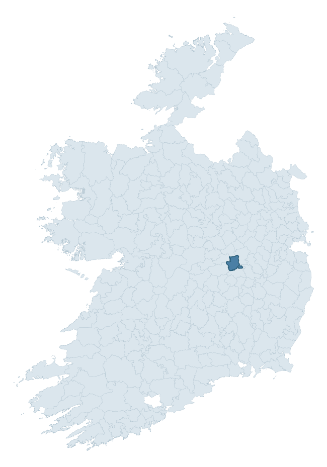
Where this barony sits in the Republic of Ireland
Geology and preservation
Bedrock geology shapes the landscape long before any settlement begins — controlling soil drainage, agricultural potential, the survival of upstanding monuments, and the preservation of buried archaeology. The figures below come from the Geological Survey Ireland 1:100,000 bedrock map.
The bedrock underlying Philipstown Upper is predominantly limestone (85% of the barony by area), laid down during the Carboniferous period (100% by area, around 359 to 299 million years ago). Limestone is the most heritage-rich bedrock in Ireland. It supports fertile, well-drained soils that favoured dense Early Medieval settlement and Norman manorial agriculture, and it weathers into karst features — sinkholes, caves, swallow holes, and souterrains — that frequently carry archaeology. Where peat overlies limestone, organic preservation can be exceptional. A substantial secondary geology of oolitic limestone (15%) adds further variety to the underlying landscape. The single largest mapped unit is the Waulsortian Limestones (57% of the barony's bedrock). With only 2 distinct rock types mapped, the barony is geologically uniform compared to the rest of the Republic (12th percentile for diversity) — a single coherent bedrock landscape.
Rock type composition
Largest mapped unit: Waulsortian Limestones (57% of the barony)
Placename evidence
Logainm records 12 heritage-diagnostic placenames for Philipstown Upper, a modest sample drawn predominantly from the townland record. The dominant stratum is early christian ecclesiastical. The most frequent diagnostic roots are cill- (6) and ráth- (3). With a sample of this size the count should be treated as indicative rather than definitive.
Pre-Christian / Early Medieval Defensive
| Root | Count | Meaning |
|---|---|---|
| ráth- | 3 | earthen ringfort |
| dún- | 1 | hilltop or promontory fort |
Early Christian Ecclesiastical
| Root | Count | Meaning |
|---|---|---|
| cill- | 6 | church (early) |
| teampall- | 1 | church (later medieval) |
| cillín- | 1 | unconsecrated burial ground |
Other baronies in Offaly
About this profile
Click any section below to expand.
What is a barony?
A barony is a historic administrative unit in Ireland, broadly equivalent to an English hundred. The 280 baronies used here are from the OSi 2019 National Statutory Boundaries (generalised 20m), covering the 26 counties of the Republic of Ireland. Baronies derive from the Norman period, were formalised in the 17th century, and have not been redrawn for statistical purposes. They vary enormously in area, from compact urban baronies in Dublin to vast upland baronies in Connacht, and should not be compared by raw site count without accounting for area differences.
What counts as a site?
This profile combines three distinct heritage registers, each with its own definition of what constitutes a recordable site:
- Archaeological sites (NMS). The National Monuments Service Sites and Monuments Record (SMR) catalogues every known archaeological monument or site of archaeological interest in the Republic, from prehistoric burial mounds and ringforts to medieval churches and post-medieval defensive works. Inclusion does not require legal protection — only that the site has been identified, surveyed, and assessed as having archaeological value. A separate subset of these sites lies within a recorded protection zone, which gives them statutory protection under the National Monuments Acts.
- Listed buildings (NIAH). The National Inventory of Architectural Heritage records buildings of architectural, historical, archaeological, artistic, cultural, scientific, social, or technical interest. Each surveyed structure is appraised on a five-tier scale: International, National, Regional, Local, and Record-Only. The NIAH appraisal is informational rather than strictly statutory, but it underpins local-authority Record of Protected Structures (RPS) listings.
- Heritage placenames (Logainm). Logainm is the authoritative database of Irish placenames maintained by the Placenames Branch. This profile applies a heritage-diagnostic classifier to the Irish-language form of each townland name, flagging roots that signal defensive sites (ráth-, lios-, dún-, caiseal-, cathair-), ecclesiastical foundations (cill-, teampall-, domhnach-, mainistir-), prehistoric burial-ritual features (tuaim-, carn-, leaba-), or Norse-contact settlement (gall-). Townlands without one of these diagnostic roots are not flagged here — they may still carry historical significance, but that significance is not encoded in the name itself.
Editorial principles
The narrative sections of this profile follow several explicit principles:
- Evidential. Every claim about this barony’s heritage character is anchored in the underlying register data. Where a site count, a placename count, or a percentile rank is cited, it is computed from the source datasets at export time, not estimated.
- Comparative. Counts and metrics are reported alongside their percentile rank against the other 279 ROI baronies. A barony with 50 ringforts in absolute terms could be unusually high or unusually low depending on its size and regional context; percentile ranking removes that ambiguity.
- Transparent on limits. Where a register has known coverage gaps, survey biases, or data-quality issues that affect this barony’s figures, the profile flags them rather than presenting the numbers as definitive.
- No interpretation beyond what the data supports. The narrative does not speculate about historical events, social dynamics, or cultural meaning beyond what the recorded heritage and placename evidence directly attests.
Data caveats and limits
- NMS Sites and Monuments Record is the product of survey campaigns conducted at different intensities across different counties and decades. Some baronies have been surveyed more thoroughly than others, and absolute counts should be read in that light. Sites destroyed by development before survey are typically not represented; sites in heavily forested or upland terrain are sometimes under-recorded.
- NIAH coverage is broadly complete for the Republic of Ireland but the survey was conducted on a rolling county-by-county basis, and the most recent appraisal date varies. Buildings demolished or substantially altered after their original survey may still appear in the register; conversely, recent buildings of merit may not yet have been appraised.
- Logainm classification applies a deliberately conservative pattern-matching approach to the Irish-language townland forms. The classifier prioritises true positives over recall: a townland may carry a heritage signal that the classifier doesn’t recognise, particularly where the diagnostic root has been heavily anglicised or where the townland name draws on a less common term. The 60,000+ townland records and ~9,800 classified placenames give a substantial signal at barony scale, but individual townland names should be checked against Logainm directly for definitive interpretation.
- Period attribution. The chronological distribution reflects only those NMS sites that carry a recognised period attribution in the source data. Sites listed as “Unknown” period are excluded from the dated subset.
- Boundary changes. Some baronies have undergone minor boundary adjustments since their 19th-century definition; the OSi 2019 generalised boundaries used here are the current statutory definition and may differ slightly from historical maps in border areas.
- Bedrock geology is mapped at 1:100,000 scale, which means local variation within a barony — small pockets of different rock type, mineral veins, alluvium overlying bedrock — is generalised. The dominant-system and rocktype figures are area-weighted, so a barony reading “70% Carboniferous limestone” may still contain small but archaeologically important pockets of older or younger rock. Around 3% of GSI polygons do not match the lexicon and contribute no rocktype or system attribution.
Data sources
- National Monuments Service — Sites and Monuments Record (SMR) https://data.gov.ie/dataset/national-monuments-service-archaeological-survey-of-ireland
- National Inventory of Architectural Heritage (NIAH) https://data.gov.ie/dataset/national-inventory-of-architectural-heritage-niah-national-dataset
- Logainm — Placenames Database of Ireland https://www.logainm.ie/
- Ordnance Survey Ireland — National Statutory Barony Boundaries 2019 https://data-osi.opendata.arcgis.com/
- EURODEM — European Digital Elevation Model https://www.mapsforeurope.org/datasets/euro-dem
- ESA WorldCover https://esa-worldcover.org/en
- Geological Survey Ireland — 1:100,000 Bedrock Geology https://www.gsi.ie/en-ie/data-and-maps/Pages/Bedrock.aspx
Explore more: Search any of the 280 ROI baronies, browse by historical province, or read the methodology and data sources for the full Republic of Ireland Heritage Tool.