
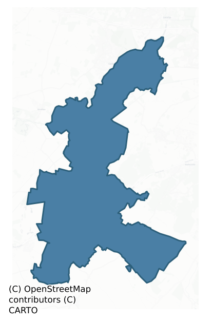
Salt South is a barony of County Kildare, in the historical province of Leinster (Irish: An Léim Theas), covering 68 km² of land. The barony records 139 NMS archaeological sites and 28 NIAH listed buildings, placing it at around the 56th percentile among 280 ROI baronies for sites per km². This means it is in the upper half of all baronies for sites per km². Dated archaeological evidence runs from the Early Bronze Age through to the Post Medieval, spanning 6 of 9 archaeological periods, placing the barony in the 13th percentile among 280 ROI baronies for chronological depth. This means it is in the bottom fifth of all baronies for chronological depth. The largest dated subset of recorded sites dates to the Iron Age.
Heritage at a glance
Percentile rankings throughout this profile compare each barony only against the other 279 Republic of Ireland baronies.
The recorded heritage of Salt South
The National Monuments Service Sites and Monuments Record (SMR) is the statutory inventory of archaeological sites for the Republic of Ireland, maintained by the Department of Tourism, Culture, Arts, Gaeltacht, Sport and Media. Sites recorded here include earthworks, ringforts, megalithic tombs, ecclesiastical remains, and post-medieval features; not every record is legally protected, but each is registered as a monument of archaeological interest.
The National Monuments Service records 139 archaeological sites in Salt South, putting it at the 56th percentile among 280 ROI baronies for sites per km². This means it is in the upper half of all baronies for sites per km². Protection coverage is near-universal — 126 sites (91%) fall within a recorded monument protection zone, indicating an extensively surveyed landscape. The record is dominated by defensive sites — ringforts, enclosures, hillforts, and stone forts (46 sites, 33% of the total), with ecclesiastical sites forming a substantial secondary presence (31 sites, 22%). The most diagnostically specific type is Church (11 records, 8% of the barony's NMS total) — compared to an ROI average of 4% across all baronies where this type occurs. Church is a building used for public Christian worship, of any date from c. 500 AD onwards. The broader 'Enclosure' classification — which catches unclassified ringforts and field enclosures — accounts for a further 25 records (18%) and reflects the difficulty of sub-classifying degraded earthworks from surface evidence alone. Across the barony's 68 km², this gives a recorded density of 2.05 sites per km².
Most common monument types
Hover or tap a monument type to see its definition.
| Type | Count |
|---|---|
| Enclosure a banked or ditched feature of uncertain type, used as a catch-all where the original function cannot be determined from surface evidence | 25 |
| Church a building used for public Christian worship, of any date from c. 500 AD onwards | 11 |
| Graveyard a burial area associated with a church, in use from the medieval period onwards | 10 |
| Ring-ditch a circular ditch under 20m across, often the ploughed-out remains of a barrow, ring-barrow or roundhouse | 6 |
| Castle – tower house a fortified residential tower of four or five storeys, mostly built by lords in the 15th and 16th centuries and often within a defended bawn | 4 |
| Ecclesiastical enclosure a large enclosure surrounding an Early Medieval church or monastery and its associated activity areas | 4 |
| Bawn the defended courtyard of a medieval house, tower house or fortified house | 4 |
Chronological distribution
The dated archaeological record for Salt South spans from the Early Bronze Age through to the Post Medieval, with activity attested across 6 of 9 archaeological periods. This is the 13th percentile across ROI baronies — a relatively narrow chronological band, with much of Irish prehistory not represented in the dated record. Every period from earliest to latest is represented in the record — an unbroken sequence of dated activity across the full chronological span. Activity concentrates most heavily in the Iron Age (29 sites, 32% of dated material), with the Early Medieval forming a secondary peak (27 sites, 29%). A further 47 recorded sites (34% of the overall NMS register for the barony) carry no period attribution — appearing as 'Unknown' in the bar chart below. This typically reflects either records that pre-date the standardised period vocabulary or sites awaiting specialist dating review, rather than a genuine absence of chronological evidence.
Sample of recorded monuments
Show 25 sample monuments (of 139 total)
A representative sample of 25 recorded monuments drawn from the barony’s 139 total NMS entries. Sites within a recorded monument protection zone and rarer site types are prioritised so the list shows a meaningful cross-section rather than only the most common type. Each entry shows the official Sites and Monuments Record reference number and the description published by the National Monuments Service.
Religious house – Augustinian canons
St Wolstan's, known as 'Scala Caeli' – 'Steps of Heaven', was founded by Richard, the first prior, and Adam de Hereford c. 1205 for the Augustinian canons of St Victor. The priory was suppressed in 1536 when Richard…
St Wolstan's, known as 'Scala Caeli' – 'Steps of Heaven', was founded by Richard, the first prior, and Adam de Hereford c. 1205 for the Augustinian canons of St Victor. The priory was suppressed in 1536 when Richard Weston, the last prior, was seized of the site (with gardens, orchards, cottages, etc) and the property was granted to John Allen, Lord Chancellor (Gwynn and Hadcock 1970, 193). On a short, gentle, N-facing pasture slope on the S bank of the R. Liffey. The very poorly preserved remains are very similar in layout to the Augustinian Priory at Athassel, Co. Tipperary (TS068-013—-), founded slightly earlier, c. 1200. No ecclesiastical buildings survive and the upstanding remains comprise the defensive, enclosing elements of the priory. An inner rectangular area (dims. L c. 100m E-W; Wth c. 80m N-S) immediately S of the river is defined along the W and N by a small tributary of the Liffey, and by a partially stone-faced drain or fosse along the E. A faint fosse along the S noted in 1985 (SMR file) is no longer clearly visible. The inner area was entered via a main gatehouse mid-way along the S side, and there is a second, small gate (postern gate?) mid-way along the E. A third, outer gateway, c. 180m to the SE, marks the outer extent of the priory. The OS 6-inch map records a fourth 'Gate' located almost midway between the main inner and outer gates, of which no visible surface trace survives: it was drawn by A. Cooper in 1782 as a two storied, circular tower with…
House – 17th century
According to Bence-Jones (1978, 253), the house originally belonged to the Alen family and was 'said to have been built in the early 17th century by John Allen, the architect of Strafford's great palace at Naas…
According to Bence-Jones (1978, 253), the house originally belonged to the Alen family and was 'said to have been built in the early 17th century by John Allen, the architect of Strafford's great palace at Naas (Jigginstown House (KD019-033001-)). Subsequently much altered and now of 18th century aspect: 3 storey, 5 bay, gable-ended centre block with 2 storey overlapping wings. … Interior remodelled 1830's'. Currently in use as a convent. Inaccessible on date of visit (June 2000).
Compiled by: Gearóid Conroy
Date of upload: 10 June 2011
Inauguration site
According to Killanin and Duignan (1967, 160), ' … Lyons Hill (is) one of the early royal seats and public assembly places of the kingdom of Leinster, and later chief seat of the Mac Giolla Mo-Cholmógs of Uí Dúnlainge.…
According to Killanin and Duignan (1967, 160), ' … Lyons Hill (is) one of the early royal seats and public assembly places of the kingdom of Leinster, and later chief seat of the Mac Giolla Mo-Cholmógs of Uí Dúnlainge. … It is also one of the places claimed as the scene of Daniel O'Connell's celebrated duel with D'Esterre (1815)' . On a hilltop (OD 651 feet) in former demesne land with panoramic views in all directions, especially S-W-NE. A very poorly preserved oval area (ext. diams. 63m E-W; 55m N-S) is defined by a low scarp (H0.3-0.9m) which is retained by thin, flaggy, facing-stones which are visible in a short arc (L 3m) at W, and intermittently at NW where grazing has denuded the sod cover, and by a very broad and shallow outer fosse (Wth 12m; D 0.9m) ENE-E-ESE which separates the monument from a natural spur immediately to the E. At the centre of the monument, a low, poorly preserved, circular cairn (diam. 10m; H 1.5m) carries a concrete OS Trigonometrical Station. (CUCAP ATC 45: 1967)
Compiled by: Gearóid Conroy
Date of upload: 10 June 2011
Round tower
In the SW corner of a graveyard (KD015-007004-) which also contains a medieval parish church (KD015-007005-). The remains consist of the lower portions (H 10m) of a round tower (ext. diam 4.8m; av. wall T 1.1m), built…
In the SW corner of a graveyard (KD015-007004-) which also contains a medieval parish church (KD015-007005-). The remains consist of the lower portions (H 10m) of a round tower (ext. diam 4.8m; av. wall T 1.1m), built of coursed limestone masonry. The round-headed, granite doorway c. 2.5m above ground level has slightly inwardly inclining jambs, and faces E. Three floor-levels can be identified and one round-headed window survives at first-floor level, looking S. The round tower and nearby church are National Monuments (No. 190) in State ownership. (Fitzgerald 1891-5, 84-6; Killanin and Duignan 1967, 329; Lennox-Barrow 1979, 123-4; Bradley et al. 1986 vol. 4, 408-9; Harbison 1992, 192)
Compiled by: Gearóid Conroy
Date of upload: 10 June 2011
House – 16th/17th century
Named 'Castlenarning' on the Down Survey (1655-6), where it is shown as a large gabled house in the vicinity of the current 'Castlewarden House', which dates to the late-18th/19th century and which, according to Garner…
Named 'Castlenarning' on the Down Survey (1655-6), where it is shown as a large gabled house in the vicinity of the current 'Castlewarden House', which dates to the late-18th/19th century and which, according to Garner and Craig (Foras Forbatha 1976, 56: SMR File) may be on the site of 'an important seventeenth century house' . Now the clubhouse of 'Castlewarden Golf and Country Club'. A motte and bailey (KD015-009001-) stands c. 300m to the NW.
In 2002, a building survey and archaeological test-trenching (Excavation Licence No. 02E0346: www.excavations.ie) was undertaken before construction of an extension to 'Castlewarden House'. The Down Survey representation was interpreted as suggesting a fortified or semi-fortified house akin to the small 17th-century house at Derrin, Co. Laois (Craig 1982, 135), or a larger, T-plan or H-plan building with two or four flanking towers. The west/central footprint of the existing building at basement/ground-floor level contained thick walls (T 0.6-0.8m) that, while heavily rendered, might incorporate parts of a 17th-century structure: these walls formed a T-shape, measuring 12.8m east-west by 6m, with the stem of the T projecting north for a further 6m and encompassing a staircase. Some 18th-century components were present on the exterior of the building, particularly in the south façade, indicating some renovation and/or rebuilding at that time. Castlewarden House had been added to several times in the last twenty years. The areas adj…
Standing stone
A very tall, tapering, granite pillar (H c. 5.3m; lower dims L c. 0.85m NW-SE; Wth c. 0.75m) stands at the centre of an enclosure (KD019-022001-). A cist (KD019-022001-) was found immediately to its NW. Excavation of…
A very tall, tapering, granite pillar (H c. 5.3m; lower dims L c. 0.85m NW-SE; Wth c. 0.75m) stands at the centre of an enclosure (KD019-022001-). A cist (KD019-022001-) was found immediately to its NW. Excavation of the cist also revealed that the standing stone was set in a rock-cut socket-hole in the natural bedrock. The monument is the subject of a Preservation Order (No.95). The occurrence of standing stones associated with enclosures is known elsewhere in County Kildare, including Punchestown (KD024-0099001- and KD024-0099002-) and Mullaghmast (KD036-010—- and KD036-017—-). (Herity 2002, 23 (66); De Burg 1896, 315, 317, 324; Mayo, Earl of, 1899-1902, 57, 59; Synnott 1899-1902, 454, 466-8; Macalister/Praeger/Armstrong 1912-14, 288-295; Killanin and Duignan 1967, 384; Waddell 1970, 119; Weir 1980, 167)
Compiled by: Gearóid Conroy
Date of upload: 10 June 2011
This monument is subject to a preservation order made under the National Monuments Acts 1930 to 2014 (PO no. 95/1940).
Cairn – burial cairn
Towards the N end of a narrow, moderately steep-sided pasture ridge on the landscaped grounds of Furness House. An earthen enclosure (KD019-022001-) containing a standing stone (KD019-022002-) and a cist burial…
Towards the N end of a narrow, moderately steep-sided pasture ridge on the landscaped grounds of Furness House. An earthen enclosure (KD019-022001-) containing a standing stone (KD019-022002-) and a cist burial (KD019-022003-) stands c. 65m to the N. Archaeological excavation in the early 1980's revealed that a low, grass-covered, circular mound (diams. 17.5m N-S; 17m E-W; max H 0.6m) delimited by a kerb of large stones, was composed of earth, stone and gravel, and had a central, oval-shaped stone core overlying a small central stake hole (charcoal dated GrN-1540 + 30BP). Several pits, and two deposits of cremated bone, one of which consisted of the remains of an adult were uncovered and finds included a portion of a blue glass bracelet, and a bronze ring (Grogan 1983-84, 298-315).
Compiled by: Gearóid Conroy
Date of upload: 10 June 2011
Hillfort
A low, domed hill (OD 120-153m) on the W-edge of rising ground which climbs gently E to the foothills of the Wicklow mountains, and overlooks lower tillage and pasture to the W. Two widely spaced (av. Wth c. 120m),…
A low, domed hill (OD 120-153m) on the W-edge of rising ground which climbs gently E to the foothills of the Wicklow mountains, and overlooks lower tillage and pasture to the W. Two widely spaced (av. Wth c. 120m), concentric, hedged, earthen banks generally follow two contours to enclose the hill. The lower, outer enclosure is complete (est. diam. c. 570m). The inner enclosure (est. diam. c. 350m) survives WSW-NW-NNE, and while an aerial photograph (GSI N384) shows the crop marks of fosses completing the circuit NNE-S-WSW, no visible surface trace of these features was located in the heavy vegetation covering parts of the interior of the monument. The interior was subdivided by later field boundaries radiating between the two enclosing elements, some of which, at NW, have since been levelled. A small enclosure (KD020-002—-) lies in the E sector, between the inner and outer enclosures.
The hillfort was recently described in the Atlas of Hillforts of Britain and Ireland as following; 'Multiple enclosure surrounding the low, domed summit and W slopes of Kill hill. The site is situated at the NE foothills of the Wicklow Mountains and overlooks the town of Naas to the SW. The site comprises three widely spaced (on average 120m apart) concentric enclosing elements which are circular in plan, measuring approximately 593 meters in maximum diameter. The site has a total footprint of 26.2ha. The outer enclosing elements comprise earthen banks topped with modern hedges and are li…
Ringfort – rath
In level, well-drained pasture. A raised, circular area (diam. 42.5m; H 1m at SW – 3m elsewhere), with a slightly concave surface, is defined by a broad fosse (W 4m; D. 1m) W-N-ESE, infilled elsewhere, and by slight…
In level, well-drained pasture. A raised, circular area (diam. 42.5m; H 1m at SW – 3m elsewhere), with a slightly concave surface, is defined by a broad fosse (W 4m; D. 1m) W-N-ESE, infilled elsewhere, and by slight traces of a possible outer earthen bank at NW. Visible on a 2005 aerial photo (OSi Orthophoto)
Compiled by: Gearóid Conroy
Date of upload: 10 June 2011
Ritual site – holy well
Fitzgerald (1915-7, 494) described, 'St. Bridget's Well on Mr. Lyon's farm (as) … now sadly neglected; it is unenclosed, and trodden around by cattle. Though a strong flow of water boils up in it, yet from its position…
Fitzgerald (1915-7, 494) described, 'St. Bridget's Well on Mr. Lyon's farm (as) … now sadly neglected; it is unenclosed, and trodden around by cattle. Though a strong flow of water boils up in it, yet from its position by the side of a gripe, it would require a native of the locality to point it out.' Jackson (1979-80, 161) says the well was visited for toothache and earache cures and tokens were left at it. It was said to have been formerly linked via St. Brigid's path to her church at Kill (KD019-008002-). However, the well was not associated with a pattern and is now covered by a pump house. Visible on a 2005 aerial photo (OSi Orthophoto) with a very large drainage channel leading NNE from the well-house. A holy tree (KD020-004001-) once stood nearby. (Herity 2002, 23 (65))
Compiled by: Gearóid Conroy
Date of upload: 10 June 2011
Religious house – Knights Hospitallers
A preceptory of Knights Hospitallers of St John of Jerusalem was founded sometime before 1212 by Maurice Fitzgerald on the site of 'Cell céli críst' (KD020-007002-) an early monastery (Gwynn and Hadcock 1970, 334, 338).…
A preceptory of Knights Hospitallers of St John of Jerusalem was founded sometime before 1212 by Maurice Fitzgerald on the site of 'Cell céli críst' (KD020-007002-) an early monastery (Gwynn and Hadcock 1970, 334, 338). No foundation charter or original grant of land survives and one of the earliest references to the preceptory is in the Justiciary Rolls of 1308. Three general chapters of the order were held at Kilteel in 1326, 1333 and 1334, and from the 14th century onwards Kilteel held an important position strategically between the Irish in Wicklow and the Anglo-Normans in Kildare and Dublin (Manning 1982, 176-7). On the moderate, SE-facing, pasture slope of a minor valley through which a small stream (now dried up) flowed SW, and overlooked by slightly higher ground WSW-N-NE. The surviving remains are generally very poorly preserved and comprise: A) a large, roughly rectangular, earthen enclosure; B) a ruined building; C) the remains of a gatehouse, and D) the ruins of a possible second gatehouse. A fine tower house (KD020-006—-) with attached gatehouse (KD020-006001-) and possible bawn (KD020-006002-), located at the NW corner of the remains, augmented the defences in the 15th century, and presumably influenced the line chosen for the Pale Boundary, portion of which (KD020-008—-) runs immediately S and W of the preceptory. Portion of high cross (KD020-007005-) stands on the roadside bordering the remains along the NW.
A) Enclosure (IG E 298495 N 221251: ITM E…
Cross – High cross
National Monument No. 275. On the roadside on the NW edge of a preceptory of Knights Hospitallers of St John of Jerusalem (KD020-007003-) which was founded on the site of 'Cell céli críst' (KD020-007002-) an early…
National Monument No. 275. On the roadside on the NW edge of a preceptory of Knights Hospitallers of St John of Jerusalem (KD020-007003-) which was founded on the site of 'Cell céli críst' (KD020-007002-) an early monastery, immediately to the S and W of which portion of the Pale Boundary runs (KD020-008—-). Fragments of a 12th century sandstone cross consist of the head with only one arm surviving (dims. H 0.95m, est. original Wth of arms c. 1.28m; T 0.38m) and the base (dims. L 1.05m; Wth 0.74m; H 0.47m). The head is not ringed, but does have a volute in the armpits. One face bears a tall diamond-shaped panel in relief which may carry interlace decoration, and there is a raised but seemingly undecorated panel on the arm. The other face is badly damaged. It has a raised square at the centre of the head, but appears to be undecorated. The base bears arcading; six on each face and four on each side/end. (Crawford 1907, 221; Ó Ríordáin 1947, 86-7; Harbison 1992, 134-5, Figs. 448, 449)
Compiled by: Gearóid Conroy
Date of upload: 10 June 2011
Burial
In 1936, digging operations in a sand ridge uncovered evidence of burials, but the discovery was only reported and investigated by the NMI in 1939. Material subsequently collected by the NMI actually comprised evidence…
In 1936, digging operations in a sand ridge uncovered evidence of burials, but the discovery was only reported and investigated by the NMI in 1939. Material subsequently collected by the NMI actually comprised evidence of two burials from two different locations: a prehistoric burial (KD020-011—-) and unburnt human remains comprising adult skull fragments and fragments of a mandible and rib from a juvenile aged 5-7 years. A bone sample was dated 935 ± 35 BP. An object described as a “copper spoon” was said to have been found with the bones. A bullaun stone (KD020-028—-) was also recorded in the vicinity. (Cahill and Sikora 2011, Vol 1, 218-21)
Compiled by: Gearóid Conroy
Date of upload: 10 June 2011
Urn burial
In 1936, digging operations in a sand ridge uncovered evidence of burials, but the discovery was only reported and investigated by the NMI in 1939. Material subsequently collected by the NMI actually comprised evidence…
In 1936, digging operations in a sand ridge uncovered evidence of burials, but the discovery was only reported and investigated by the NMI in 1939. Material subsequently collected by the NMI actually comprised evidence of two burials from two different locations: unburnt human remains of early medieval date (KD020-010—-) and the remains of a prehistoric burial. This comprised fragments (subsequently restored) of a small bowl food vessel (H 0.1m; base diam 0.06m; rim diam. 0.15m) decorated with a panel of conjoined lozenges, a panel of shapes like stretched hides, panels of both horizontal and vertical impressed lines, and four impressed grooves of circular form. (Cahill and Sikora 2011, Vol 1, 218-21)
Compiled by: Gearóid Conroy
Date of upload: 10 June 2011
Armorial plaque
Affixed to the wall above the back door of a disused, late-18th/19th century farmhouse abutting Reeves castle (KD015-002001-). A small plaque (est. dims. Wth c. 0.4m; H c. 0.5m) carries a horizontally elongated lozenge…
Affixed to the wall above the back door of a disused, late-18th/19th century farmhouse abutting Reeves castle (KD015-002001-). A small plaque (est. dims. Wth c. 0.4m; H c. 0.5m) carries a horizontally elongated lozenge motif with small central boss, which is flanked above by two more bosses, above which are a further two, slightly smaller bosses, each of which appears to carry an animal motif (? a hound), obscured by dense green-mould.
Compiled by: Gearóid Conroy
Date of upload: 10 June 2011
Earthwork
On a slight SW-facing slope, in meadow, overlooking the Kilteel complex (KD020-006—-, KD020-006001-, KD020-006002- and KD020-007002- to KD020-007012-) across the road to the SE. Visible on aerial photos taken in 1963…
On a slight SW-facing slope, in meadow, overlooking the Kilteel complex (KD020-006—-, KD020-006001-, KD020-006002- and KD020-007002- to KD020-007012-) across the road to the SE. Visible on aerial photos taken in 1963 (CUCAP AIG064) and 1966 (CUCAP APA056 and API002) and indicated on Manning's interpretative tracing of same included in his Kilteel Church (KD020-007002-) excavation report (1982, 219). Visible as a broad, low, earthen bank (Wth 9-11m; H 0.2-0.3m; traceable L c. 46m NE-SW), with no obvious trace of an associated fosse. May be associated with the preceptory earthworks (KD020-007003-), or, is possibly a continuation of the Pale Boundary (KD020-008—-) which runs S and then W to the S of this site.
Compiled by: Gearóid Conroy
Date of upload: 17 January 2012
Tomb – effigial
This is the original location of the 'Castledillon Stone', a very fine 13th century effigial slab of limestone now in the Market House in Kildare town – see KD022-029073-.
Compiled by: Gearóid Conroy
Date of…
This is the original location of the 'Castledillon Stone', a very fine 13th century effigial slab of limestone now in the Market House in Kildare town – see KD022-029073-.
Compiled by: Gearóid Conroy
Date of upload: 10 June 2011
Rock art (present location)
Found in 1975 during ploughing (location designated KD019-025—-) c. 100m S of Furness Church (KD019-024001-) in the graveyard of which (KD019-024002-) it now lies. A boulder of local metamorphosed greywacke (dims. L…
Found in 1975 during ploughing (location designated KD019-025—-) c. 100m S of Furness Church (KD019-024001-) in the graveyard of which (KD019-024002-) it now lies. A boulder of local metamorphosed greywacke (dims. L 1.33m; Wth 0.97m; H 0.50m) is decorated on one face with a pattern of six groups of concentric circles, cupmarks and combinations of both. (Shee 1975-6, 496-500; Meagher 1974-9, 118)
Compiled by: Gearóid Conroy
Date of upload: 10 June 2011
Cross
In Furness Church (KD019-024001-). A small, plain, granite cross (H 0.53m; Wth 0.42m) has chamfered edges. May be post-medieval in date.
Compiled by: Gearóid Conroy
Date of upload: 10 June 2011
Graveslab
Found during conservation work outside the S wall of the nave of Kilteel church (KD020-007002-). A fragment of a coffin-shaped slab with two hollow mouldings along the chamfered edges and a raised stem up the centre. It…
Found during conservation work outside the S wall of the nave of Kilteel church (KD020-007002-). A fragment of a coffin-shaped slab with two hollow mouldings along the chamfered edges and a raised stem up the centre. It is of probable 13/14 century date. (Manning 1981-82, 205, 207).
Compiled by: Gearóid Conroy
Date of upload: 10 June 2011
Children's burial ground
To the S of a church (KD014-016—-) in a graveyard (KD014-016001-) in the NE sector of a possible early ecclesiastical enclosure (KD014-016004-) which is the site of a possible Early Christian monastery (KD014-016003-)…
To the S of a church (KD014-016—-) in a graveyard (KD014-016001-) in the NE sector of a possible early ecclesiastical enclosure (KD014-016004-) which is the site of a possible Early Christian monastery (KD014-016003-) and is the original location of the fine, 13th century 'Castledillon Stone' effigy (KD014-016002-). Burials concentrated in a small area immediately S of the church are marked by small, uninscribed field stones, in occasional, random lines, suggestive of a children's burial ground.
Compiled by: Gearóid Conroy
Date of upload: 10 June 2011
Ritual site – holy tree/bush
Associated with St Brigid's Holy Well (KD020-004—-). Fitzgerald (1915-7, 494) records that, 'Some years ago a sally tree stood near it (the holy well), which bore the usual load of votive rags etc.'
Compiled by:…
Associated with St Brigid's Holy Well (KD020-004—-). Fitzgerald (1915-7, 494) records that, 'Some years ago a sally tree stood near it (the holy well), which bore the usual load of votive rags etc.'
Compiled by: Gearóid Conroy
Date of upload: 10 June 2011
Font (present location)
Located on the lawn of a house. A roughly dressed, octagonal font (dims. max. L 0.61m; max. Wth 0.61m; L of sides 0.25-0.28m; H 0.22m) contains a central, circular basin (diam. 0.29m). Record no. KD020-026001- was…
Located on the lawn of a house. A roughly dressed, octagonal font (dims. max. L 0.61m; max. Wth 0.61m; L of sides 0.25-0.28m; H 0.22m) contains a central, circular basin (diam. 0.29m). Record no. KD020-026001- was created for the unknown original location of this monument.
Compiled by: Gearóid Conroy
Date of upload: 10 June 2011
Barrow – embanked barrow
Situated on elevated grassland with good views. Low roughly circular shaped earth and stone mound (approx. diam. 12m; H 0.3m) best preserved at W with some dumping of field clearance debris at E. The centre of the…
Situated on elevated grassland with good views. Low roughly circular shaped earth and stone mound (approx. diam. 12m; H 0.3m) best preserved at W with some dumping of field clearance debris at E. The centre of the mound appears to have a hollow depression but this feature was difficult to interpret due to the growth of nettles and other vegetation on the mound.
Compiled by: Caimin O'Brien based on details provided by Chris Corlett
Date of upload: 21 July 2017
Enclosure
Visible on a GSI aerial photograph (W 467-6) as the cropmark of a possible enclosure. On level pasture in a stud farm c. 200m W of a castle (KD011-016—-) and c. 250m SW of a possible enclosure (KD011-030—-). No…
Visible on a GSI aerial photograph (W 467-6) as the cropmark of a possible enclosure. On level pasture in a stud farm c. 200m W of a castle (KD011-016—-) and c. 250m SW of a possible enclosure (KD011-030—-). No visible surface traces survive.
Compiled by: Gearóid Conroy
Date of upload: 10 June 2011
Listed buildings
The National Inventory of Architectural Heritage (NIAH) is a state survey appraising buildings of architectural, historical, archaeological, artistic, cultural, scientific, social, or technical interest. Each surveyed structure receives a rating from International (the highest, for buildings of European importance) through National, Regional, Local, and Record-Only.
The NIAH records only 28 listed buildings in Salt South, the 12th percentile across ROI baronies — a relatively thin architectural record. All recorded buildings carry Regional or lower grading; the barony does not contain any structures appraised as being of National or International architectural importance. Construction dates concentrate most heavily in the Victorian (1830-1900) period. The most-recorded building type is house (8 examples, 29% of the listed stock).
Terrain and environment
Mean elevation across the barony is 118m — the 72nd percentile among 280 ROI baronies for elevation. This means it is in the top third of all baronies for elevation. This is a relatively elevated landscape by ROI standards. Elevation matters for heritage because higher-altitude baronies typically favour defensive monuments — ringforts and hilltop forts placed on prominent ground — while lowland baronies are more likely to carry the dense settlement and church networks of intensive agricultural landscapes. The barony reaches 384m at its highest point — a vertical span of more than 265m within its boundary, indicating significant topographic diversity. Mean slope is 3.1° — the 39th percentile among 280 ROI baronies for slope. This means it is in the lower half of all baronies for slope. Slope is a key control on both land use and archaeological preservation: steep ground resists ploughing and tends to preserve earthworks intact, while gentle slopes favour intensive cultivation that damages or destroys surface archaeology over time. The Topographic Wetness Index averages 11.2, the 62nd percentile among 280 ROI baronies for wetness. This means it is in the upper half of all baronies for wetness. Drainage matters for heritage because poorly-drained ground preserves organic archaeology (wooden trackways, leather, textiles, and on rare occasions human remains) far better than free-draining soil; well-drained ground favours arable use but destroys organic material rapidly. The land-cover mosaic combines improved grassland (65%), arable farmland (17%), and woodland (14%), giving a mixed agricultural and semi-natural landscape.
Terrain measurements
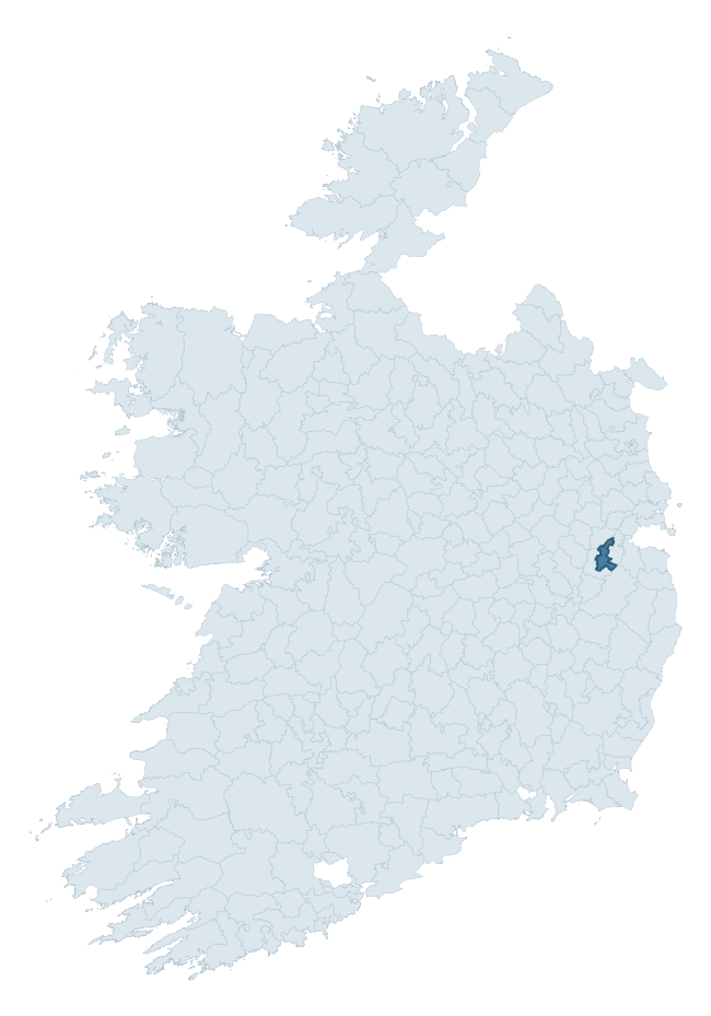
Where this barony sits in the Republic of Ireland
Geology and preservation
Bedrock geology shapes the landscape long before any settlement begins — controlling soil drainage, agricultural potential, the survival of upstanding monuments, and the preservation of buried archaeology. The figures below come from the Geological Survey Ireland 1:100,000 bedrock map.
The bedrock underlying Salt South is predominantly calcareous greywacke (41% of the barony by area), laid down during the Silurian period (56% by area, around 444 to 419 million years ago). A substantial secondary geology of limestone (41%) adds further variety to the underlying landscape. The single largest mapped unit is the Carrighill Formation (41% of the barony's bedrock).
Rock type composition
Largest mapped unit: Carrighill Formation (41% of the barony)
Placename evidence
Logainm records 4 heritage-diagnostic placenames for Salt South, a modest sample drawn predominantly from the townland record. The dominant stratum is early christian ecclesiastical. The most frequent diagnostic roots are cill- (2) and domhnach- (1). With a sample of this size the count should be treated as indicative rather than definitive.
Early Christian Ecclesiastical
| Root | Count | Meaning |
|---|---|---|
| cill- | 2 | church (early) |
| domhnach- | 1 | pre-Patrician or earliest Patrician church |
| díseart- | 1 | hermitage |
Other baronies in Kildare
About this profile
Click any section below to expand.
What is a barony?
A barony is a historic administrative unit in Ireland, broadly equivalent to an English hundred. The 280 baronies used here are from the OSi 2019 National Statutory Boundaries (generalised 20m), covering the 26 counties of the Republic of Ireland. Baronies derive from the Norman period, were formalised in the 17th century, and have not been redrawn for statistical purposes. They vary enormously in area, from compact urban baronies in Dublin to vast upland baronies in Connacht, and should not be compared by raw site count without accounting for area differences.
What counts as a site?
This profile combines three distinct heritage registers, each with its own definition of what constitutes a recordable site:
- Archaeological sites (NMS). The National Monuments Service Sites and Monuments Record (SMR) catalogues every known archaeological monument or site of archaeological interest in the Republic, from prehistoric burial mounds and ringforts to medieval churches and post-medieval defensive works. Inclusion does not require legal protection — only that the site has been identified, surveyed, and assessed as having archaeological value. A separate subset of these sites lies within a recorded protection zone, which gives them statutory protection under the National Monuments Acts.
- Listed buildings (NIAH). The National Inventory of Architectural Heritage records buildings of architectural, historical, archaeological, artistic, cultural, scientific, social, or technical interest. Each surveyed structure is appraised on a five-tier scale: International, National, Regional, Local, and Record-Only. The NIAH appraisal is informational rather than strictly statutory, but it underpins local-authority Record of Protected Structures (RPS) listings.
- Heritage placenames (Logainm). Logainm is the authoritative database of Irish placenames maintained by the Placenames Branch. This profile applies a heritage-diagnostic classifier to the Irish-language form of each townland name, flagging roots that signal defensive sites (ráth-, lios-, dún-, caiseal-, cathair-), ecclesiastical foundations (cill-, teampall-, domhnach-, mainistir-), prehistoric burial-ritual features (tuaim-, carn-, leaba-), or Norse-contact settlement (gall-). Townlands without one of these diagnostic roots are not flagged here — they may still carry historical significance, but that significance is not encoded in the name itself.
Editorial principles
The narrative sections of this profile follow several explicit principles:
- Evidential. Every claim about this barony’s heritage character is anchored in the underlying register data. Where a site count, a placename count, or a percentile rank is cited, it is computed from the source datasets at export time, not estimated.
- Comparative. Counts and metrics are reported alongside their percentile rank against the other 279 ROI baronies. A barony with 50 ringforts in absolute terms could be unusually high or unusually low depending on its size and regional context; percentile ranking removes that ambiguity.
- Transparent on limits. Where a register has known coverage gaps, survey biases, or data-quality issues that affect this barony’s figures, the profile flags them rather than presenting the numbers as definitive.
- No interpretation beyond what the data supports. The narrative does not speculate about historical events, social dynamics, or cultural meaning beyond what the recorded heritage and placename evidence directly attests.
Data caveats and limits
- NMS Sites and Monuments Record is the product of survey campaigns conducted at different intensities across different counties and decades. Some baronies have been surveyed more thoroughly than others, and absolute counts should be read in that light. Sites destroyed by development before survey are typically not represented; sites in heavily forested or upland terrain are sometimes under-recorded.
- NIAH coverage is broadly complete for the Republic of Ireland but the survey was conducted on a rolling county-by-county basis, and the most recent appraisal date varies. Buildings demolished or substantially altered after their original survey may still appear in the register; conversely, recent buildings of merit may not yet have been appraised.
- Logainm classification applies a deliberately conservative pattern-matching approach to the Irish-language townland forms. The classifier prioritises true positives over recall: a townland may carry a heritage signal that the classifier doesn’t recognise, particularly where the diagnostic root has been heavily anglicised or where the townland name draws on a less common term. The 60,000+ townland records and ~9,800 classified placenames give a substantial signal at barony scale, but individual townland names should be checked against Logainm directly for definitive interpretation.
- Period attribution. The chronological distribution reflects only those NMS sites that carry a recognised period attribution in the source data. Sites listed as “Unknown” period are excluded from the dated subset.
- Boundary changes. Some baronies have undergone minor boundary adjustments since their 19th-century definition; the OSi 2019 generalised boundaries used here are the current statutory definition and may differ slightly from historical maps in border areas.
- Bedrock geology is mapped at 1:100,000 scale, which means local variation within a barony — small pockets of different rock type, mineral veins, alluvium overlying bedrock — is generalised. The dominant-system and rocktype figures are area-weighted, so a barony reading “70% Carboniferous limestone” may still contain small but archaeologically important pockets of older or younger rock. Around 3% of GSI polygons do not match the lexicon and contribute no rocktype or system attribution.
Data sources
- National Monuments Service — Sites and Monuments Record (SMR) https://data.gov.ie/dataset/national-monuments-service-archaeological-survey-of-ireland
- National Inventory of Architectural Heritage (NIAH) https://data.gov.ie/dataset/national-inventory-of-architectural-heritage-niah-national-dataset
- Logainm — Placenames Database of Ireland https://www.logainm.ie/
- Ordnance Survey Ireland — National Statutory Barony Boundaries 2019 https://data-osi.opendata.arcgis.com/
- EURODEM — European Digital Elevation Model https://www.mapsforeurope.org/datasets/euro-dem
- ESA WorldCover https://esa-worldcover.org/en
- Geological Survey Ireland — 1:100,000 Bedrock Geology https://www.gsi.ie/en-ie/data-and-maps/Pages/Bedrock.aspx
Explore more: Search any of the 280 ROI baronies, browse by historical province, or read the methodology and data sources for the full Republic of Ireland Heritage Tool.